83 F. high in the Twin Cities Saturday.
82 F. average high on June 28.
79 F. high on June 28, 2013.
.42" fell yesterday at MSP International.
11.27" rainfall so far in June.
11.67" all-time June rainfall record for MSP (1874).
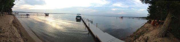
Living a Vacation
Sometimes you don't realize you're spoiled until you travel elsewhere, and then return with new eyes, new perspective.
Our
friends from Cincinnati moved here a few years ago and marveled at the
lakes - the charming towns. "It's like living a vacation!" Stacey Hyre
said. But why would Twin Cities residents pack up and drive hours to be
on a different lake, she wondered? To disconnect, to get out of your
bubble, your weekday rut, and reconnect as a family, away from everyday
distractions, I explained.
Truth? It took me 20 years to figure that out.
Have
a Plan B again today at the cabin, or in the metro area. In fact the
best chance of severe storms later today will come over southern
Minnesota and Iowa, where a few large tornadoes can't be ruled out. Kind
of puts the mosquitoes into perspective. Today will be sunnier &
warmer than yesterday statewide, but stay alert for severe storms by
late afternoon. Don't push the weather.
We cool off later this
week, but a stubborn pool of chilly air aloft sparks more showers
Tuesday & Wednesday. Thursday looks magical before a rerun of
late-week humidity & storms.
Is a tropical storm about to form off the Carolinas? Check the blog below.
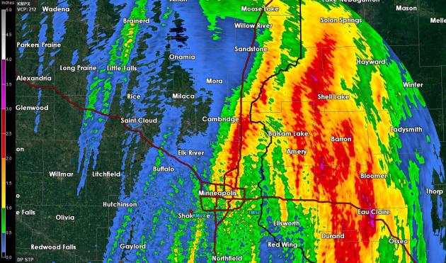
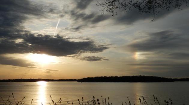
Saturday Rainfall Amounts.
There are NWS Doppler-derived, showing 1-2" rainfall estimates from
Roseville and Shoreview to Cambridge; the heaviest rains soaked western
Wisconsin. Officially .42" rain fell in the Twin Cities yesterday, at
least at the airport, where all things official are recorded.
Maps Still Don't Look Like June.
NOAA NAM's 84 hour Future Radar product shows an unusually intense
storm spinning over southern Manitoba and Saskatchewan, whipping up
enough wind shear aloft for potentially severe storms later today,
especially southern Minnesota and Iowa. This storm, more typical for
early May than late June, will drag cool air southward in its wake by
midweek. Loop: HAMweather.
Temporary Canadian Relief by Midweek.
Extended models show a cooler, drier, more comfortable pattern
returning by midweek, with Thursday probably the best day of the week.
The approach of this cooler front sets off thunder Monday, with showery
rains possible Tuesday PM into a portion of Wednesday. Dew points drop
into the 50s by midweek, meaning much more comfortable air floating
overhead. We warm up to near 80F on the 4th as clouds and humidity
levels increase, a slight chance of a storm for the 4th of July; a
better chance of more widespread storms next Saturday. Source:
Weatherspark.
Alerts Broadcaster Briefing: Issued Saturday evening, June 28, 2014.
*
Another significant severe storm outbreak expected Sunday afternoon
from the Twin Cities to Des Moines and Kansas City. Right now the
greatest risk of damaging winds, including a few large tornadoes, will
be over Iowa by late afternoon and evening.
* Flash flood risk
returns to much of Upper Midwest as thunderstorms repeatedly pass over
the same waterlogged counties. Some additional 1-4" amounts are
possible; the threshold for flash flooding is roughly 1.5 to 2" for many
locations from Iowa and western Wisconsin into southern and central
Minnesota.
* It's still early, but long-range models are hinting
at a possible tropical depression or tropical storm impacting the
Carolinas around the 4th of July, then tracking right up the East Coast
next weekend - capable of producing coastal flooding and inland flash
flooding.
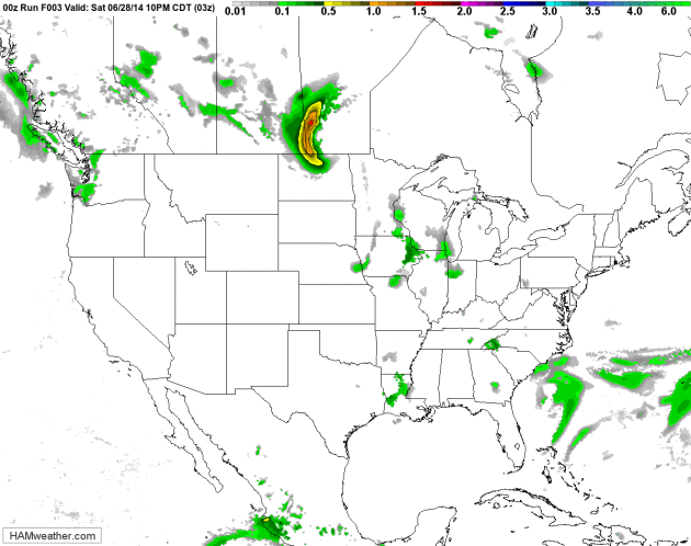
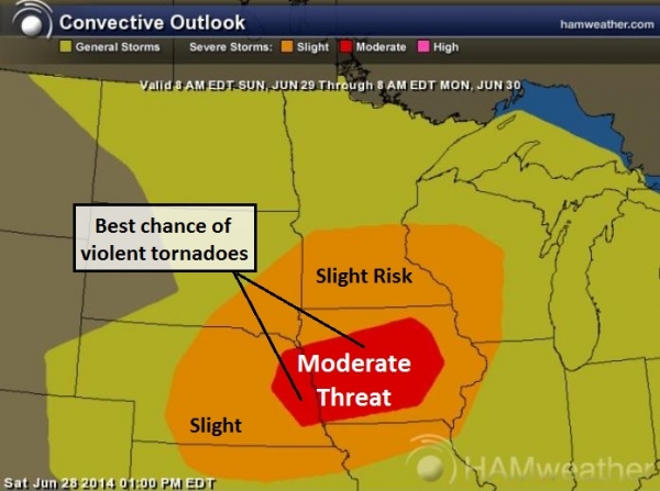
Sunday Storm Risk.
A "Moderate Threat" as defined by NOAA SPC really implies "strong risk"
of enhanced T-storms capable of large hail, 75+ mph winds and a handful
of damaging EF-2+ intensity tornadoes capable of significant damage and
injury. That will be the case Sunday, especially Iowa after roughly 3
PM, when the atmosphere is most unstable and volatile. A few smaller
(more isolated) tornadoes can't be ruled out from central Minnesota and
western Wisconsin into northern Missouri, Nebraska and eastern South
Dakota. Graphic: HAMweather.
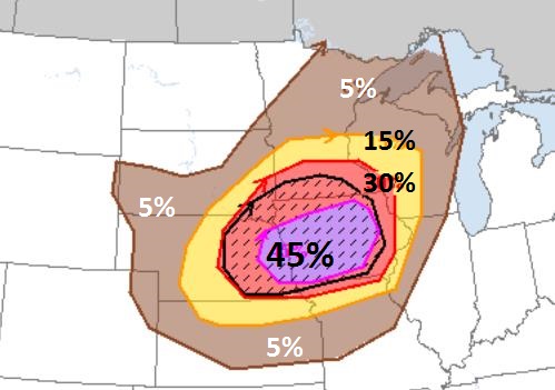
Pinpointing the Greatest Sunday Damaging Storm Risk.
A 45% bulls-eye means a nearly 50-50 chance of severe weather within 25
miles of any location from Lincoln and Omaha to Des Moines and
Waterloo, Iowa. The black hatched area shows a 10% risk of "enhanced
severe weather", which is meteorological shorthand for 2"+ hail, winds
over 75 mph. and large EF-2+ intensity tornadoes within 25 miles of any
location. Across Minnesota the greatest risk of severe weather Sunday
falls from the Twin Cities to the Iowa border, including Rochester,
Mankato and Redwood Falls. Map: NOAA SPC.
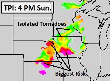
TPI: Tornado Potential Index.
Alerts Broadcaster's proprietary TPI shows the greatest risk of large
tornadoes by late afternoon from eastern Nebraska to near Des Moines,
but there may be enough instability, low-level moisture and wind shear
for a few isolated tornadoes into southern Minnesota and western
Wisconsin. Map: HAMweather.
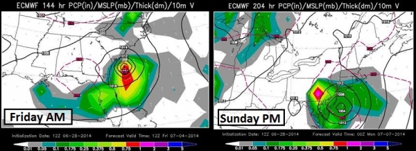
Tropical Whispers Next Weekend?
From the outset let me state that my Confidence Level for tropical
development along the East Coast is a 2 on a scale from 1 to 10. I'm
showing this (now) because of the risk of coastal flooding during the
4th of July weekend, when even more people than usual will be camped out
along the Atlantic coastline. I want to offer as much runway as
possible, in the slight chance that this forecast verifies. ECMWF
(European) guidance shows a tropical depression or possible tropical
storm spinning up off the Carolina coast by Friday morning, the 4th,
pushing into the Outer Banks of North Carolina Saturday the 5th, and
then spreading up the eastern seaboard, much like a classic nor'easter
over the weekend. There is a potential for heavy rain and some coastal
flooding from the Carolinas into much of the Mid Atlantic and coastal
New England within 5-7 days, including New York City. Full-blown
hurricane development is highly unlikely, but remember that a
slow-moving tropical depression or storm can squeeze out even more rain
than a typical hurricane moving at 10-20 mph. Stating the obvious, we'll
keep an eye on this scenario and update if the threat level increases
for East Coast facilities. Map credit: WSI.
Paul Douglas - Senior Meteorologist - Alerts Broadcaster
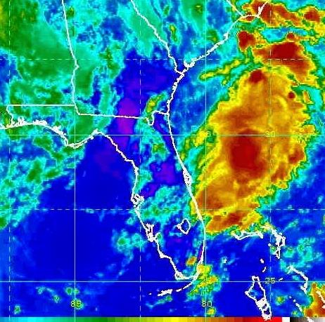
NOAA: 60% Chance Tropical Cyclone Forms Off Florida. The ECMWF may be on the right track - here's an excerpt of a story at
brevardtimes.com: "
As
of 2 p.m. Eastern Daylight Time on Saturday, June 28, 2014, NOAA's
National Hurricane Center in Miami, Florida, has issued a tropical
weather outlook due to the presence of a broad low pressure system that
is producing disorganized showers and thunderstorms off the coasts of
South Carolina, Georgia, and Florida. NOAA says that environmental
conditions are expected to remain conducive for gradual development of
this system while it drifts southward of the coast of Georgia and
Florida during the next few days. NOAA
forecasts that development of this system, if any, has a medium chance
(50%) of becoming a tropical cyclone during the next 48 hours and a high
(60%) chance within the next 5 days..." (Image credit above: NOAA).
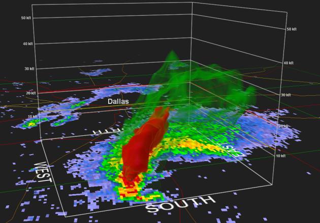
Weather Officials Reject Claim That Radar Technology Makes Storm Chasers, Spotters Obsolete.
Because as good as Doppler is, there's no way to confirm a storm is
spawning an actual funnel or tornado, or 2.5" diameter hail unless you
have a (trained) spotter or chaser in the vicinity to provide ground
truth and verification. That, and the curvature of the Earth makes it
impossible to know if a rapidly rotating supercell T-storm is actually
spawning severe weather more than 75 miles from the radar site. Here's
an excerpt of a story at
kansas.com: "
Weather
officials in Tornado Alley are offering firm rebuttals to a national
magazine article’s claim that new radar technology makes storm chasers
“obsolete” and storm spotters virtually unnecessary. In a Slate.com
article titled “Why This Former Storm Chaser Now Thinks Stalking
Tornadoes Is Unethical,” meteorologist Eric Holthaus writes..."
Read more here: http://www.kansas.com/2014/06/28/3531124/weather-officials-reject-claim.html#storylink=cpy
On Track For A Record Statewide June Rainfall Record?
We don't have far to go to see a statewide rainfall record fall by the
wayside; a very good chance 2014 will eclipse 1914 as the wettest June
in recorded history. Here's an excerpt from Dr. Mark Seeley's weekly
WeatherTalk Newsletter: "...
Though
June temperatures around the state were near normal, rainfall was far
from it, in fact record-setting for many communities. On a statewide
basis the average rainfall for June so far has been about 7.29 inches,
just behind the all-time wettest June of 1914 when the statewide average
was 7.32 inches, a record likely to be broken by next Monday. Flooding
has been widespread on many Minnesota watersheds as a result of the
heavy rains..."
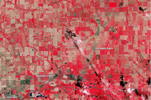
Nebraska's Twin Tornadoes Scarred The Earth. Here's a clip from an interesting story via
Capital Weather Gang: "...
The pair of violent tornadoes that ripped through Pilger, Nebraska June 16 did more than loft a house into the air and damage half the town.
The twisters left a mark on the terrain visible 443 miles above the
Earth from space. NASA’s Advanced Spaceborne Thermal Emission and
Reflection Radiometer (ASTER) instrument aboard its Terra satellite
attained the image below (from June 21, 2014) revealing the paths of the
destructive tornado tandem..." (Image credit above: NASA).
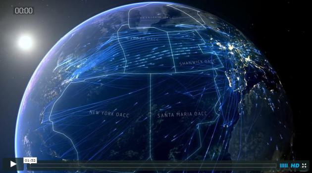
North Atlantic Skies. There's a lot of air traffic out there - more than you might imagine. Check out this video animation and story from
Vimeo; here's an excerpt: "...
This
visualization shows Transatlantic traffic over a 24 hour period taken
from a day in August last year and shows 2,524 flights crossing the
North Atlantic, of which 1,273 pass through the Shanwick OCA. At our
busiest periods in the Summer, traffic can peak at 1,500 flights a day
passing through the Shanwick OCA..."
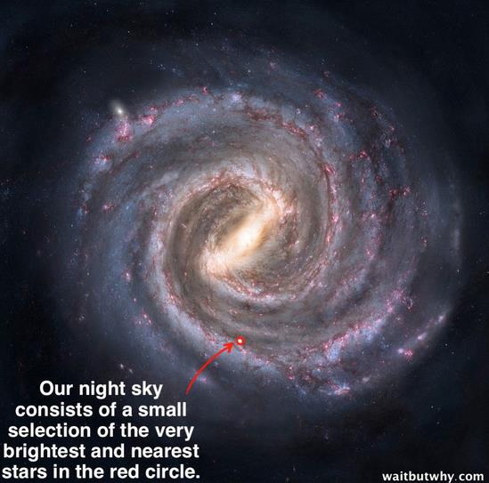
The Fermi Paradox. If there are aliens lurking out there, why haven't we heard from them yet? Here's a clip from a thought-provoking article at
Wait But Why: "...
SETI
(Search for Extraterrestrial Intelligence) is an organization dedicated
to listening for signals from other intelligent life. If we’re right
that there are 100,000 or more intelligent civilizations in our galaxy,
and even a fraction of them are sending out radio waves or laser beams
or other modes of attempting to contact others, shouldn’t SETI’s satellite array pick up all kinds of signals? But it hasn’t. Not one. Ever. Where is everybody?..."
The Perils Of Sitting.
Wait, I lettered in sitting in high school; I was really, really good
at it. I'm still gifted. But I should get off my butt a little bit more
often after reading this article at
Quartz; here's a clip: "...
It’s been linked to cancer, diabetes, and cardiovascular disease. In
this latest meta-analysis, Daniela Schmid and Michael F. Leitzmann of
the University of Regensburg in Germany analyzed 43 observational
studies, amounting to more than 4 million people’s answers to questions
about their sitting behavior and cancer incidences. The researchers
examined close to 70,000 cancer cases and found that sitting is
associated with a 24% increased risk of colon cancer, a 32% increased
risk of endometrial cancer, and a 21% increased risk of lung cancer..."
TODAY: Partly sunny, severe storms late? Winds: SW 15. High: 87
SUNDAY NIGHT: Evening T-storms over southern MN and western WI, some severe. Low: 68
MONDAY: Still unsettled, another T-storm possible. High: 82
TUESDAY: Sunny start, PM showers. Wake-up: 64. High: 74
WEDNESDAY: Cool, lingering clouds & showers. Wake-up: 60. High: near 70
THURSDAY: Sunny & beautiful. Dew point: 52. Wake-up: 56. High: 79
4th of JULY: Clouds increase, stray T-storm. Wake-up: 62. High: 82
SATURDAY: Shocker: sticky with more T-storms. Wake-up: 67. High: 84
Climate Stories...
KSTP Denies Report Stanley Hubbard Is Sponsoring Climate Change Denial Conference.
City Pages has the story - here's an excerpt: "
In a report,
Media Matters dings Stanley Hubbard for "co-sponsoring a Heartland
Institute conference promoting climate denial" and alleges Hubbard's
skepticism has "seeped into [his] stations' reporting." Hubbard's
flagship station, of course, is KSTP. But KSTP News Director Lindsay
Radford tells us Media Matters has it wrong about the upcoming
conference and overstates Hubbard's influence on her newsroom..."
Calling Out The Delayers. It's
getting harder for rational, data-driven people to deny the reality of
climate change, so they're moving on to a different tactic: let's delay
action until we know more, or have better technology, or other countries
step up first, etc. etc. Here's a clip of an Op-Ed at
MetroWest Daily News in Framingham, MA: "
...Delayers"
often profess agreement with the scientific consensus and support for
climate action, at least in theory. Voices like Bjorn Lomborg, Roger
Pielke Jr. and others at the Breakthrough Institute have pioneered this
tactic, which establishes credibility and grants entrance into a
mainstream media increasingly closed to the denial of basic science. But
after token acknowledgement of the problem, a litany of excuses for
inaction begins, often on economic grounds..."


No comments:
Post a Comment