86 F. high in the Twin Cities Saturday.
74 F. average high on May 31.
79 F. high on May 31, 2013.
.05" rain fell as of 7 PM Saturday at MSP International Airport.
May 31 in Minnesota Weather History. Source: Twin Cities NWS.
1993: St. Cloud reported its latest ever freezing temperature.
1897: Cold night in Tower. The temperature drops to 18.
Super Soakers
I'm
thoroughly enjoying the Mosquito Olympics, now playing out in my buggy
backyard (available on ESPN7). If the rains keep up I'm going to need a
low-flying helicopter to cut my lawn.
Welcome to monsoon season in
Minnesota. Rainfall for the last 30 days is already 3-8 inches above
average for portions of central Minnesota, and the rains just keep on
coming. Once again, for the umpteenth time in recent memory, weather
systems are stalling, and when weather gets stuck you need to pay close
attention.
A stalled frontal boundary snaking across Minnesota
will ignite more heavy T-storms again today; heaviest rains on the
cooler north/west side of the front - but the MSP metro may see tropical
downpours capable of 1-2 inches, enough for standing water and
garage-worthy grad parties.
Have a Plan B and hope for the best.
A
ripple of low pressure keeps gulley-washers in the forecast into Monday
but Wednesday's storm may steer showers and storms south of the metro.
We slowly warm late next week with spotty weekend T-storms. Right on
cue.
I'm still betting on a wetter than average summer, statewide, but El Nino may keep us warmer and drier the latter half of 2014.
Keep the faith.
4.43" Sauk Centre
2.6" Breezy Point, on Pelican Lake
*
Click here for rainfall and flash flood details, courtesy of NOAA.
* more Minnesota rainfall amounts from
CoCoRaHS.
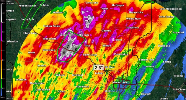
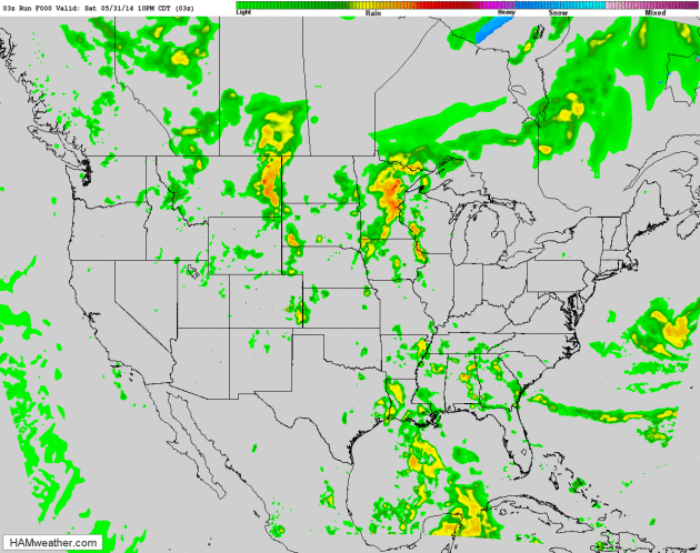
Storm Rainfall.
Check out some of the rainfall amounts from near Sauk Centre to Little
Falls and Brainerd; Doppler radar estimates of 4-8" in less than 24
hours. To put that into perspective that's 1-2 month's worth of rain
since Friday morning. Some of the northern and western suburbs of the
Twin Cities picked up 2-3" of rain.
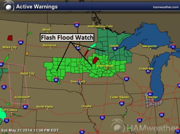
Flash Flood Watch.
NOAA has issued a flood watch for much of Minnesota, including the Twin
Cities, St. Cloud, Brainerd and Duluth. Saturated soil means any
additional heavy rain will almost immediately run off into streets and
streams. June is the wettest month of the year for Minnesota, on
average. No kidding. Details from the Twin Ciites National Weather
Service:
THE FLASH FLOOD WATCH IS NOW IN EFFECT FOR

* PORTIONS OF CENTRAL MINNESOTA...EAST CENTRAL MINNESOTA AND
  WEST CENTRAL MINNESOTA...INCLUDING THE FOLLOWING AREAS...IN
  CENTRAL MINNESOTA...BENTON...KANDIYOHI...MEEKER...SHERBURNE...
  STEARNS AND WRIGHT. IN EAST CENTRAL MINNESOTA...ISANTI...
  KANABEC AND MILLE LACS. IN WEST CENTRAL MINNESOTA...CHIPPEWA...
   LAC QUI PARLE...POPE AND SWIFT.

* THROUGH SUNDAY MORNING.

* ADDITIONAL HEAVY RAIN WITH 2 TO 4 INCHES POSSIBLE IN SPOTS
  TONIGHT COMBINED WITH SATURATED SOIL...SWOLLEN CREEKS AND
  STREAMS COULD LEAD TO FLOODING.

PRECAUTIONARY/PREPAREDNESS ACTIONS...

A FLASH FLOOD WATCH MEANS THAT CONDITIONS MAY DEVELOP THAT LEAD
TO FLASH FLOODING. FLASH FLOODING IS A VERY DANGEROUS SITUATION.

YOU SHOULD MONITOR LATER FORECASTS AND BE PREPARED TO TAKE ACTION
SHOULD FLASH FLOOD WARNINGS BE ISSUED.
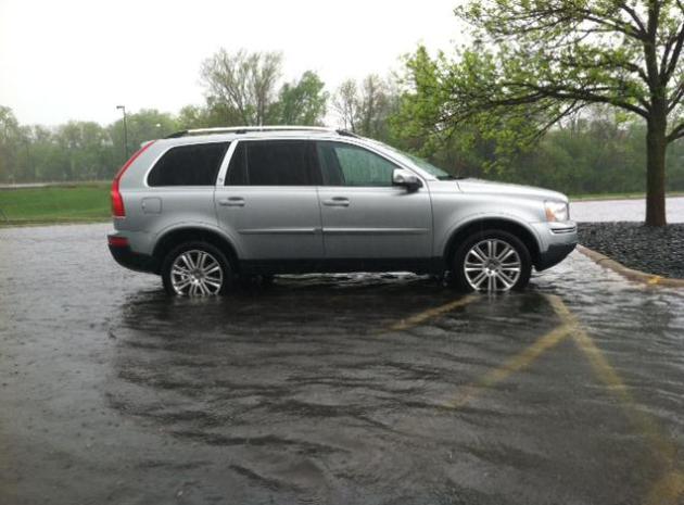
Rising Minnehaha Creek Leads to Flood Warnings.
KARE-11 has an update on the ongoing flood potential on Lake Minnetonka, which empties into Minnehaha Creek: "...
Currently,
Lake Minnetonka's water level is 930.21 feet. The MCWD is discharging
water from the Gray's Bay Dam into Minnehaha Creek. Due to high lake
levels, water is also flowing over the emergency spillway north of the
dam, which has an elevation of 930 feet. As a result of heavy rains this
spring, the lake level has been at or above 930 since May 9 and there
is no additional capacity in the lake or Minnehaha Creek for more
rainfall, increasing the likelihood for flooding in some areas..." (photo: Matt Passolt).
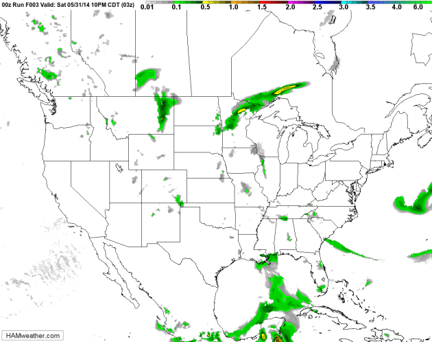
Lingering Flash Flood Potential.
NOAA's RAP model thru 4 PM Sunday shows more showers and heavy T-storms
flaring up along a stalled frontal boundary. Based on this guidance I
could see the Flash Flood Watch extended into late Sunday or early
Monday. Future Radar: HAMweather.com.
84-Hour Future Radar.
NOAA's 12 km NAM model finally dries us out during the day Monday as
winds swing around to the west and heavy T-storms pinwheel into the
Great Lakes. A dry Tuesday gives way to another risk of showers and
thundershowers Wednesday, with the greatest potential for heavy rain
south of the Twin Cities.
Protecting Your Home From Disasters. Here's a clip from a timely story at
The Wall Street Journal: "
Many
homeowners are flirting with disaster - and they may not even know it.
Natural catastrophes and severe weather events that cause major damage
are occurring more frequently and inflicting more costly harm. Insurers
have responded by putting stricter limits on their liability for losses,
forcing homeowners to take on a greater share of the risk. The result
is a growing financial incentive to prepare wisely..."
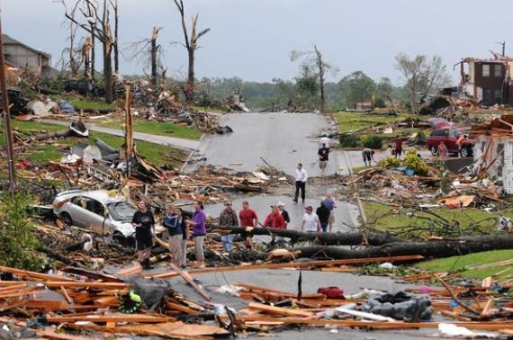
Photo credit above: "
Residents of Joplin, Mo, survey the damage after a tornado hit the city in May 2011."
Associated Press.
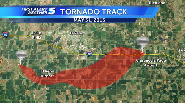
Reflecting Back on Historic (El Reno) May 31, 2013 Tornado.
KOCO-TV has a good recap of a massive EF-5 that struck outside Oklahoma City; here's a clip: "...
The
tornado also had smaller tornadoes within the larger circulation. These
are called sub-vortices. Thanks to the help of research meteorologist
Gabe Garfield, we know that one of the more intense sub-vortices moved
on the ground at 180 mph. It was also stationary at times. The Doppler
On Wheels (DOW) measured a 255 mph wind gust in one of the smaller
tornadoes just south of I-40. There were also satellite tornadoes, or
tornadoes that occur outside of the main circulation. The main gigantic
tornado also spawned a tornado with clockwise winds. Most tornadoes have
counter-clockwise winds..."
Late Start to Planting Season. Here's a clip from the latest installment of Dr. Mark Seeley's
WeatherTalk Newsletter: "...
There
were numerous reports of hail during the month, and two tornadoes were
reported on May 8th, near St James and Madelia. Straight line wind
damage occurred near Waseca, Montgomery, and Red Wing damaging
buildings, trees, and powerlines. This cool, wet spring produced a late
planting season for farmers, but nearly all of the state corn acreage
was planted by May 30, and over half of the soybean acreage was planted
as well. Southern Minnesota farmers began harvesting alfalfa the last
week of the month. Moderate drought remained in the extreme southwestern
counties of the state..."
Dust Storm Kills 12 in New Delhi. The Times of India
reports.
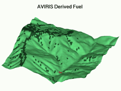
How To Read The Mind of a Wildfire. An article at
The Atlantic
has some details about how tree rings and computer models are being
tapped to gain a greater understanding of wildfires; here's a clip: "...
When
fires do burn, they're more destructive, often killing the big trees
along with the small. “What's being released in a fire is the
accumulated capital stored up through years of photosynthesis,” Falk
says. “You're not destroying the carbon, hydrogen, or oxygen molecules.
They're just being liberated.” And on a tremendous scale: even a
relatively small fire of a couple hundred acres can pump out energy
equivalent to the atomic bomb dropped on Hiroshima, and can push a
mushroom cloud of hot air, ash, and soot miles into the sky..."
Animation credit above: "
A FIRETEC animation of a 1996 blaze in Malibu." (icess.ucsb.edu).
The Wealthy, English-Speaking Country Starbucks Can't Conquer. Here's a snippet of a fascinating business case study at
Quartz: "...
The
Seattle-based chain also has a large and growing presence in
international markets: Seoul has more Starbucks locations than New York
City does, and Canada has more stores on a per capita basis than
anywhere else in the world. There
is, however, a wealthy international market where the coffee chain has
struggled: Australia. That might seem surprising, given it is one of
the world’s wealthiest countries and is also completely obsessed with coffee..."
Virgin Spaceflights Cleared For Take-Off.
Will my 250k get me peanuts and a drink? That, and a sturdy barf bag?
The FAA cleared the way for low-orbit trips later this year, as reported
by
CNN Money: "...
Virgin
Galactic has been gearing up to offer space flight services for the
general public and has said it wants to start offering flights by the
end of 2014. Branson and his family will be on Virgin's first space
flight. Virgin Galactic said it has accepted more than $70 million in
deposits from about 580 individuals. That's about 10% more than the
total number of people who have ever gone to space..."
* more fascinating details on Virgin Galactic's upcoming "flights" at
The Houston Chronicle.
TODAY:
Tropical humidity. More showers and T-storms. Downpours likely with
localized flooding problems. Dew point: 68. Winds: S 10. High: 81
SUNDAY NIGHT: A few more showers, possible thunder. Low: 67
MONDAY: Early thunder? Showers slowly taper. High: near 80
TUESDAY: Peeks of sun, drying breeze. Dew point: 55. Wake-up: 61. High: 76
WEDNESDAY: Showers and T-Showers brush far southern MN. Sun central/north. Wake-up: 57. High: 77
THURSDAY: Warm sun much of the day. Dew point: 60. Wake-up: 58 High: 78
FRIDAY: Hazy sun, pop-up T-storms possible. Wake-up: 60. High: 81
SATURDAY: Sticky sun, storms up north. DP: 64. Wake-up: 62. High: 83
Climate Stories...
Climate Change Meets Kitchen Table As Issue Gets Personal.
Will curbing emissions from coal-fired plants be a net positive or
negative, when it comes to everything from energy bills to human health?
Here's an excerpt of a post at
Bloomberg Businessweek: "
The
White House, as it prepares to announce new limits on carbon emissions,
is working to transform the debate from distant threats to more
immediate issues. President Barack Obama wants to shift the conversation
from polar bears and melting glaciers to droughts in Iowa and more
childhood asthma across the nation. Opponents are also making the issue
personal. They’re homing in on the rules’ potential kitchen-table
impact, raising the prospect of higher utility bills and job losses.
They expect those arguments to resonate with voters as the country is
still recovering from the worst recession in seven decades..."
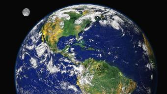
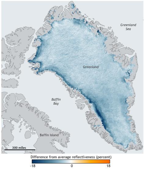 Global Warming and the Vulnerability of Greenland's Ice Sheet.
 Climate
models have consistently underestimated the rate of ice melt in
Greenland (and the Arctic). Here's an excerpt of a story at
The Guardian: "...
This
work is important because in the past decade or so, it has been found
that Greenland is losing ice, lots of ice, to the world’s oceans. As a
consequence, Greenland is one of the significant contributors to sea
level rise. The level our oceans will rise to in the next decades and
centuries depends strongly on how fast the Greenland
ice sheet will melt. This study is novel because of the way it combined
measurements with mass-conservation calculations. The method allowed
far better resolution of the thickness of Greenland glaciers and the
shape of the valleys beneath the glaciers. The shape and depth of these
valleys is important for moderating the speed of ice flow to the oceans.
In fact, in the paper, authors state, “the overall state of mass
balance of the ice sheet is affected by considerable uncertainties in
bed topography and ice thickness...”
GOP Science Deniers Threaten National Security. Not my headline, but from a marine veteran who is hot under the collar. Here's a snippet of his Op-Ed at
Marketwatch: "...
The Republican Party
is now officially on record as the party of climate-science denialism.
These research programs, ongoing and widely used by the Pentagon in
strategic national defense planning for many years, could, if the Senate
agrees, become illegal to use. Yes, this Marine veteran is mad as hell.
GOP science deniers have “crossed the line,” they’re now messing with
national security. America is now under attack from an enemy within,
irrational science denialism, a toxic mind-set, a spreading,
self-destructive mental virus. Yes, this is a “War on America.” The
military has been using climate-science research for decades. This vote
is self-destructive. These research studies are essential in our
national defense..."
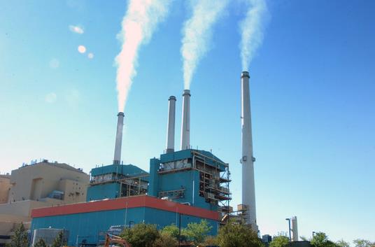
Obama Is Planning His Biggest Climate Policy Yet - And He Doesn't Need Congress.
Vox has more details on the upcoming rule changes regarding coal-fired energy; here's an excerpt: "...
Early reporting suggests
that the EPA will set overall emissions limits for each individual
state. Power companies in those states will have a variety of options
for getting below that limit — using more efficient technology, boosting
their use of solar or wind or nuclear, or even joining regional
cap-and-trade systems that require companies to pay to emit
carbon-dioxide. Early reports suggest
that US coal plants could ultimately have to reduce their emissions
around 20 percent (though we still don't know the baseline — more on
that below). Those coal plants, in turn, are responsible for about 28.7
percent of all US carbon-dioxide emissions.."
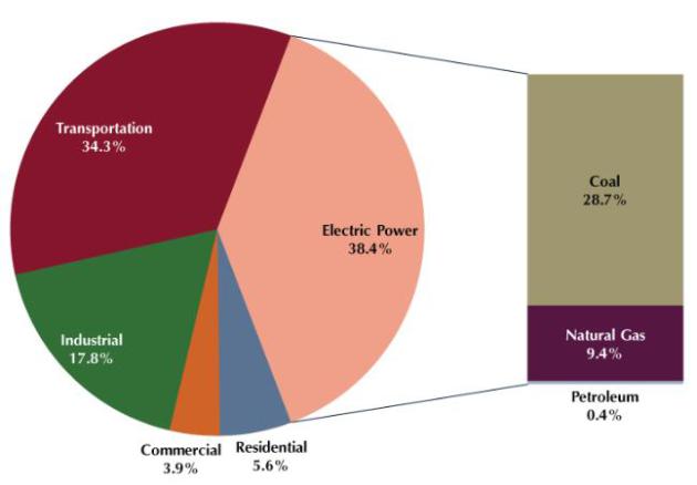
Graphic credit: Center for Climate and Energy Solutions.
How Obama's Power Plant Emission Rules Will Work. More details, and a Q and A, from
The Washington Post; here's a clip: "
Obama
says the rules are essential to curb the heat-trapping greenhouse gases
blamed for global warming. Critics contend the rules will kill jobs,
drive up electricity prices and shutter plants across the country.
Environmentalists and industry advocates alike are eagerly awaiting the
specifics, which the Environmental Protection Agency will make public
for the first time on Monday and Obama will champion from the White
House..." (File photo above: Matt Brown, AP).
The All of the Above Energy Strategy as a Path to Sustainable Economic Growth. More details and light reading in this 43 page PDF from
The White House.


No comments:
Post a Comment