By Todd Nelson
I can't help but get a little giddy when summer arrives... and it never fails, when schools let out for the summer, I find myself humming the Alice Cooper tune "School's Out"!
Nice to see weather conditions have turned more "summer-like". No more frost/freeze threats and no talk of that dirty four letter "S" word until (hopefully) late this fall. My garden is in and has recovered from the 2" to 6"+ rain last weekend. The official 2 day tally from the MSP Airport was 3.02". That was the greatest 2 day rainfall tally since June 21st and 22nd of last summer when we picked up 3.04".
Another heavy batch of rain slides south of the MN/IA border early Thursday with a few lingering showers/storms across the extreme southern part of the state through early afternoon. Thursday, a thunder risk returns to northwest MN late with thunder chances filling in across the state by PM Friday.
If you have plans over the weekend, Saturday looks a little more thundery than Sunday does. Heavy rain chances on Saturday look to tame a bit on Sunday. A brisk northwest wind Sunday will draw down some of the coolest readings we've seen in a couple of weeks... might be a good nap day!
===========================
TUESDAY NIGHT: Clouds increase, chance of showers, especially south/west of MSP. Low: 59. Winds: ESE 5mph.
WEDNESDAY: Sun north, rain far southern MN. High: 77. Winds: ENE 5-10
WEDNESDAY NIGHT: Partly cloudy and comfortable. Low: 58. Winds: ESE 5-10
THURSDAY: Some sun, few PM T-storms possible far NW Minnesota. High: 77
FRIDAY: Partly sunny, growing PM thunder risk. Wake-up: 59. High: 80
SATURDAY: Humid and unsettled, T-storms likely. Wake-up: 61. High: 74
SUNDAY: Breezy and cooler with lingering showers. Wake-up: 56. High: 68
MONDAY: Bright sun, refreshing breeze. Wake-up: 51. High: 74
TUESDAY: PM Thundershower. Wake-up: 58. High: 78.
===========================
This Day in Weather History:
June 4th
1958: Severe storms swept through northwest Wisconsin. A half-mile wide F5 tornado moved at 52 mph from south of Woodville to east of Colfax. 20 people were killed. Also, an F4 tornado took four lives at Chippewa Falls, and another F4 tornado killed four people near the small communities of Boyd and Stanley
1935: The latest official measurable snowfall in Minnesota was at Mizpah on this date with 1.5 inches.
1904: Severe windstorm on Lake Superior. 63 mph winds clocked at Duluth.
=============================
Average High/Low for MSP:
June 4th
Average High: 75F
Average Low: 55F
============================
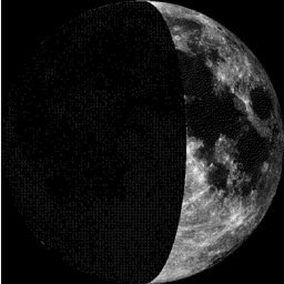
Moon Phase for June 4th at Midnight
0.6 Days Before First Quarter
==============================
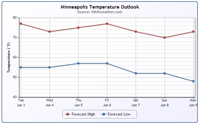
Minneapolis Temperature Trend
After such a mild stretch of weather, temps will take a bit of a dip over the coming days... not much, but it definitely looks cooler as we head into Sunday with highs struggling to get to 70F in the metro.
===================================
Lake Levels Running High
I snapped this picture Tuesday morning of Lake Minnetonka in Excelsior. It is apparent that lake levels are running quite high from the recent heavy rain event from last weekend!!


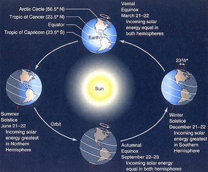
Summer Solstice
The Summer Solstice arrives on Saturday, June 21st at 5:51am CDT
==============================
Stormy Outlook Ahead
Look at the vigorous area of low pressure scooting through the central U.S.. This will be responsible for an ongoing severe weather threat through the 2nd half of the week and it tracks east. Not only will there be a severe weather threat, but a flood threat could be possible in areas that see heavy rains from convective precipitation.
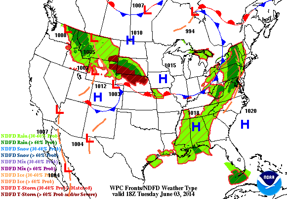
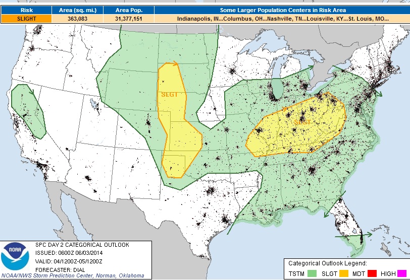
Severe Threat Wednesday
...SUMMARY... STRONG TO SEVERE STORMS WILL BE POSSIBLE FROM PARTS OF THE SOUTHERN PLAINS AND NWD INTO THE CENTRAL HIGH PLAINS AS WELL AS FARTHER EAST INTO SOUTHEASTERN VIRGINIA AND EASTERN NORTH CAROLINA. ISOLATED DAMAGING WIND AND LARGE HAIL WILL BE THE MAIN THREATS. ...SYNOPSIS... THE LOW AMPLITUDE...PROGRESSIVE SHORTWAVE TROUGH WILL MOVE OFF THE ATLANTIC SEABOARD EARLY THURSDAY...BUT A BROAD SYNOPTIC UPPER TROUGH WILL REMAIN OVER THE ERN STATES. FARTHER UPSTREAM A ZONAL PATTERN WILL PERSIST FROM THE WEST COAST EWD THROUGH THE PLAINS AND MS VALLEY REGIONS. SEVERAL LOW AMPLITUDE SHORTWAVE TROUGHS WILL MOVE THROUGH THIS FLOW REGIME. AT THE SFC A COLD FRONT WILL MOVE OFF THE ATLANTIC SEABOARD IN ASSOCIATION WITH THE EXITING SHORTWAVE TROUGH. TRAILING PORTION OF THIS BOUNDARY WILL LIKELY STALL FROM OK EWD INTO THE LOWER MS VALLEY REGION. FARTHER NORTH A COLD FRONT IS FORECAST TO MOVE THROUGH THE NRN PLAINS AREA.
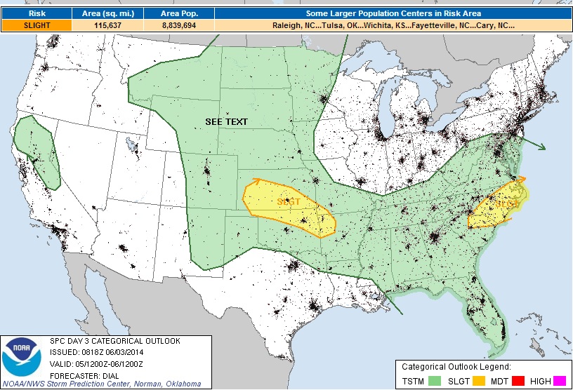
Severe Threat Thursday
...SUMMARY... STRONG TO SEVERE STORMS WILL BE POSSIBLE FROM PARTS OF THE SOUTHERN PLAINS AND NWD INTO THE CENTRAL HIGH PLAINS AS WELL AS FARTHER EAST INTO SOUTHEASTERN VIRGINIA AND EASTERN NORTH CAROLINA. ISOLATED DAMAGING WIND AND LARGE HAIL WILL BE THE MAIN THREATS. ...SYNOPSIS... THE LOW AMPLITUDE...PROGRESSIVE SHORTWAVE TROUGH WILL MOVE OFF THE ATLANTIC SEABOARD EARLY THURSDAY...BUT A BROAD SYNOPTIC UPPER TROUGH WILL REMAIN OVER THE ERN STATES. FARTHER UPSTREAM A ZONAL PATTERN WILL PERSIST FROM THE WEST COAST EWD THROUGH THE PLAINS AND MS VALLEY REGIONS. SEVERAL LOW AMPLITUDE SHORTWAVE TROUGHS WILL MOVE THROUGH THIS FLOW REGIME. AT THE SFC A COLD FRONT WILL MOVE OFF THE ATLANTIC SEABOARD IN ASSOCIATION WITH THE EXITING SHORTWAVE TROUGH. TRAILING PORTION OF THIS BOUNDARY WILL LIKELY STALL FROM OK EWD INTO THE LOWER MS VALLEY REGION. FARTHER NORTH A COLD FRONT IS FORECAST TO MOVE THROUGH THE NRN PLAINS AREA.
Heavy Rain Threat
Another big concern will be the heavy rain over sections of the central U.S.. According to NOAA's HPC, the 5 day precipitation forecast (from AM Tuesday - AM Sunday) suggests nearly 5"+ over the nation's heartland. Most of this rainfall will occur in a short period, which may cause areas to see flash flooding.
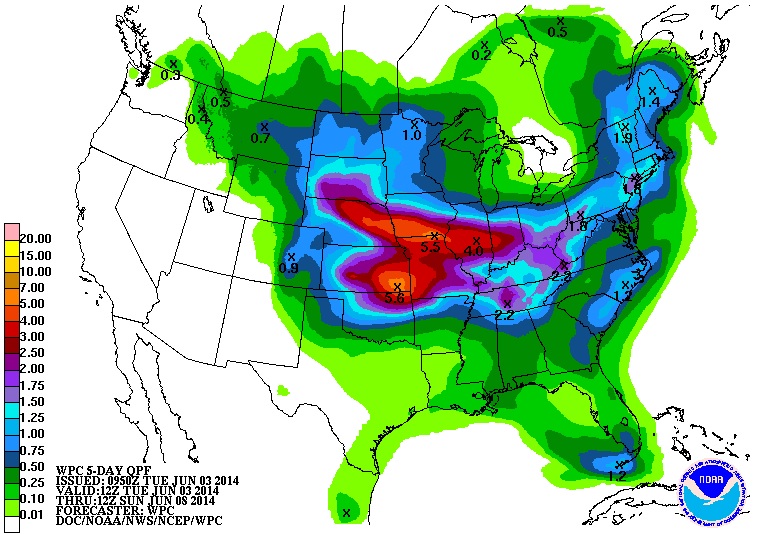
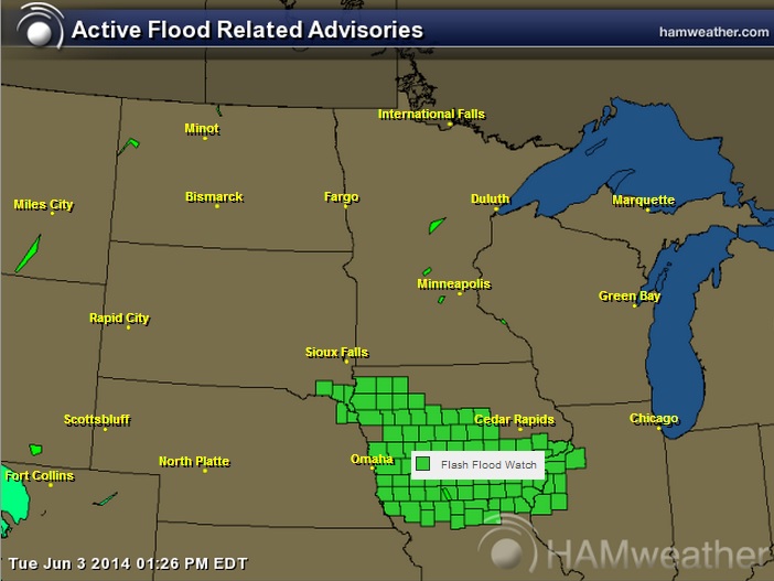
Flash Flood Watch
Through AM Wednesday:
EXCESSIVE RAINFALL RATES WILL LEAD TO HIGH RUNOFF RATES OVERNIGHT. WIDESPREAD TOTAL PRECIPITATION AMOUNTS LOOK TO RANGE FROM 2 TO 4 INCHES BY WEDNESDAY MORNING...BUT COULD SEE ISOLATED AMOUNTS OF 5 INCHES OR GREATER. * SMALL CREEKS AND STREAMS TYPICALLY SUSCEPTIBLE TO FLASH FLOODING MAY RISE VERY RAPIDLY TONIGHT...ESPECIALLY IN URBAN AREAS.
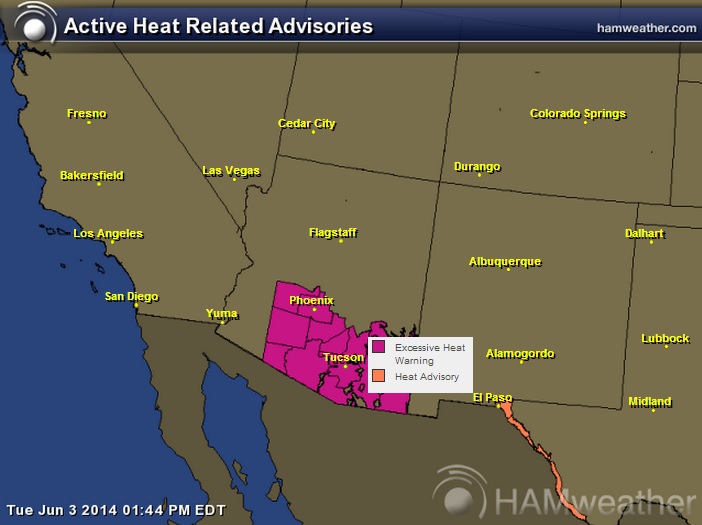
Heat Concerns
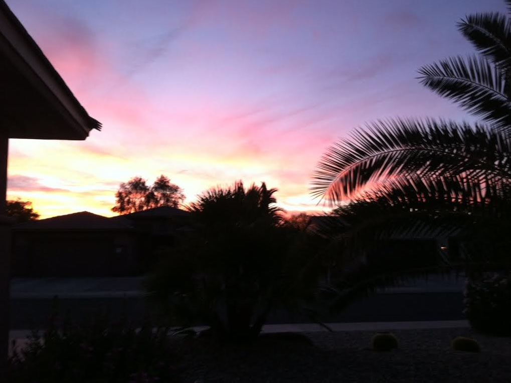
Record heat popped up earlier this week in places like Phoenix and Tucson, AZ as temperatures soared into the triple digits. It appears that more record and near record heat will continue over the next couple of days. Thanks to my parents for the pictures below from Sun City Grande. This was the sunset after a record setting 110F in Phoenix, AZ (tied 110F set in 2013).

AN EXCESSIVE HEAT WARNING REMAINS IN EFFECT UNTIL 8 PM MST THURSDAY. * AFFECTED AREA...THE PHOENIX METRO AREA AND SURROUNDING LOWER DESERTS INCLUDING GILA BEND...CASA GRANDE...COOLIDGE...AND OTHER NEARBY AREAS. * WARNING TIME EACH DAY...GENERALLY FROM 10 AM TO 8 PM. * TEMPERATURE...HIGHEST TEMPERATURES FROM 109-111 DEGREES. * IMPACTS...EXCEEDINGLY HIGH TEMPERATURES CAN CAUSE HEAT RELATED ILLNESS...EVEN DEATH. THOSE WORKING OR PLAYING OUTDOORS... THOSE WITHOUT AIR CONDITIONING...OR PEOPLE SENSITIVE TO HEAT WILL NEED TO TAKE PRECAUTIONS.
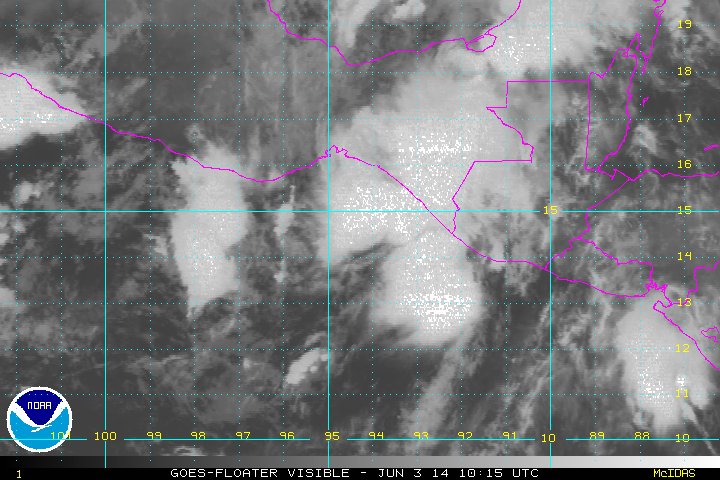
Tropical Update
This was the view of Tropical Storm Boris (BOR-EES) in the Eastern Pacific around midday Tuesday. Note the broad counterclockwise circulation just offshore (Mexico). This is our second named storm of the 2014 Eastern Pacific Hurricane Season. It was over Memorial Weekend that Hurricane Amanda rapidly developed into a category 4 storm, which became the strongest storm this early in the season for the Eastern Pacific.
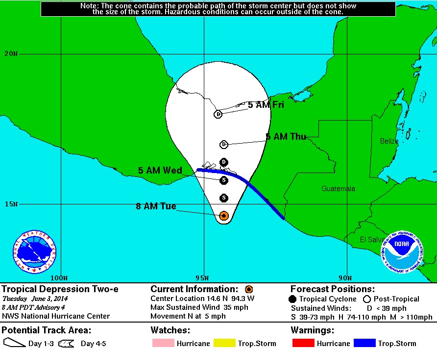
Tracking The Tropics
DISCUSSION AND 48-HOUR OUTLOOK ------------------------------ SATELLITE DATA INDICATE THAT THE DEPRESSION HAS STRENGTHENED INTO A TROPICAL STORM. AT 1100 AM PDT...1800 UTC...THE CENTER OF TROPICAL STORM BORIS WAS LOCATED NEAR LATITUDE 14.7 NORTH...LONGITUDE 94.1 WEST. BORIS IS MOVING TOWARD THE NORTH NEAR 5 MPH...7 KM/H...AND THIS GENERAL MOTION IS EXPECTED FOR THE NEXT COUPLE OF DAYS. ON THE FORECAST TRACK...THE CENTER OF BORIS SHOULD BE NEAR THE COAST OF MEXICO WITHIN THE WARNING AREA EARLY WEDNESDAY. MAXIMUM SUSTAINED WINDS HAVE INCREASED TO NEAR 40 MPH...65 KM/H...WITH HIGHER GUSTS. NO SIGNIFICANT STRENGTHENING IS EXPECTED BEFORE LANDFALL. TROPICAL STORM FORCE WINDS EXTEND OUTWARD UP TO 80 MILES...130 KM...NORTHEAST OF THE CENTER. PUERTO CHIAPAS MEXICO HAS ALREADY REPORTED 3.78 INCHES OF RAIN FROM BORIS. THE ESTIMATED MINIMUM CENTRAL PRESSURE IS 999 MB...29.50 INCHES. HAZARDS AFFECTING LAND ---------------------- WIND...TROPICAL STORM CONDITIONS ARE REACHING THE COAST WITHIN THE WARNING AREA NOW AND SHOULD CONTINUE THROUGH TONIGHT. RAINFALL...BORIS IS EXPECTED TO PRODUCE AS MUCH AS 10 TO 20 INCHES OF RAIN OVER A LARGE PART OF SOUTHERN MEXICO THROUGH SATURDAY...WITH ISOLATED AMOUNTS EXCEEDING 30 INCHES LIKELY OVER THE MOUNTAINOUS TERRAIN OF THE MEXICAN STATES OF OAXACA AND CHIAPAS. BORIS IS ALSO EXPECTED TO PRODUCE TOTAL RAINFALL AMOUNTS OF 5 TO 10 INCHES IN GUATEMALA. THESE RAINS ARE LIKELY TO RESULT IN LIFE-THREATENING FLASH FLOODS AND MUD SLIDES.
Here are the spaghetti models for Boris as he tracks over southern Mexico. Note that most have Boris drifting north near the Bay of Campeche
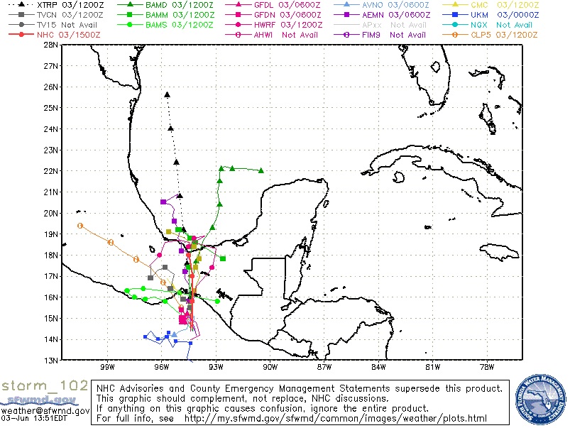
Tracking Boris
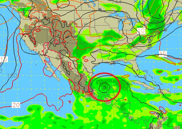
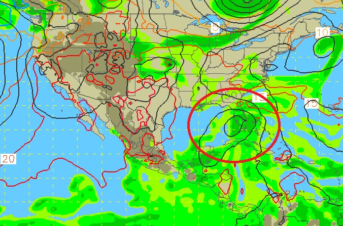
This is the GFS (American Model) outlook for Boris as he drifts north. The images below are the forecast for AM Monday and AM Wednesday of next week. Note that this particular model has Boris drifting near the Yucatan Peninsula and toward Florida! Stay tuned...
Outlook AM Monday
Outlook AM Wednesday
Thanks for checking in and have a great rest of your week ahead! Don't forget to follow me on Twitter @TNelsonWNTV

No comments:
Post a Comment