72 F. high in the Twin Cities Tuesday.
84 F. average high on July 15.
89 F. high on July 15, 2013.
Trace of rain fell at KMSP yesterday.
July 15 in Minnesota Weather History. Source: MPX (Twin Cities) National Weather Service:
2006:
Heat Burst occurs over west central and central Minnesota. The
temperature at Canby jumped from 91 degrees to 100 degrees in 40 minutes
from 10:35pm to 11:15pm. At the same time the dew point temperature
dropped from 63 to 32 degrees. A Heat Burst is caused by a dying
thunderstorm with very warm air aloft.
1963: Downpour at St. Charles with a half a foot rain in one day.
"
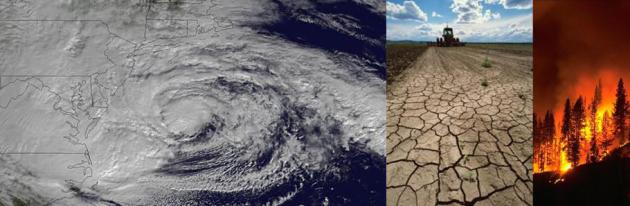
Weather,
climate and water-related disasters are on the rise worldwide, causing
loss of life and setting back economic and social development by years,
if not decades. From 1970 to 2012, 8,835 disasters, 1.94 million deaths,
and US$ 2.4 trillion of economic losses were reported globally as a
result of hazards such as droughts, extreme temperatures, floods,
tropical cyclones and related health epidemics, according to a new
report..." - World Meteorological Organization. More details
here.
The Comfort Vortex
We've
gone from whining about the dew point and heat index to chattering
about wind chill. I guess that's progress. Old fashioned air
conditioning? Open a window and give thanks for living so close to
Canada.
Is Mother Nature psychotic? Are we really experiencing
more weather extremes or, glued to social media and a proliferation of
news & weather channels, merely doing a faster/better job of finding
extremes that have been there since the dawn of time?
More people
living near rivers and coastlines, more vulnerable to the vicissitudes
of nature? Or symptom of a more energetic, chaotic atmosphere bulking up
on carbon, influencing jet stream patterns that favor more extremes?
The
World Meteorological Organization reports nearly 2 million deaths &
$2.4 trillion in economic loss from global weather disasters since
1970.
Any cool weather drama fades as the week goes on; 80s return
this weekend. It's hard to imagine but we may nick 90F next week with
more thundery downpours and dew points above 70F. Yes, neighbors will
shake their head and mumble about the humidity as early as Saturday and
Sunday.
And this week's premature puff of October will seem like a midsummer night's dream, a meteorological mirage.
A+ Weather Into Sunday - Summer Returns Next Week.
Enjoy our autumnal interlude for the next 72 hours with low humidity
(dew points in the 40s and 50s) because tropical air returns next week.
T-storms packing downpours are possible Monday into Wednesday with dew
points rising into the 70s. Next week at this time we'll be looking back
on this stretch as "the good 'ol days."
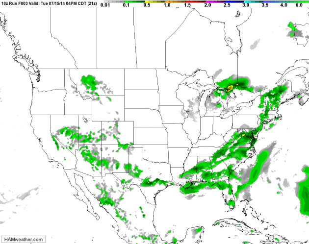
84-Hour Future Radar.
NOAA's NAM model shows heavy showers and T-storms pushing across the
Plains into the Midwest later this week; dry weather persisting over the
far western USA. Minnesota, Wisconsin and the Dakotas enjoy a dry
stretch of weather which may last right into the weekend. Loop:
HAMweather.
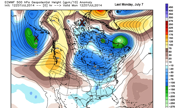
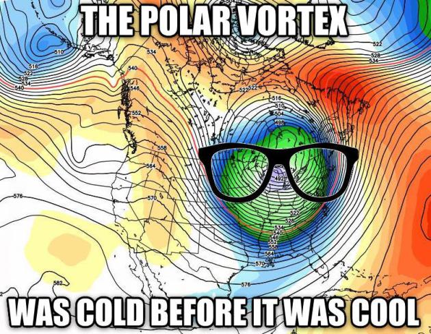
Polar Vortex Deniers Are Wrong, Here's Why.
Meteorologist Jason Samenow has a good explanation of why it is, in
fact, appropriate to refer to the chilly air that sailed through here as
a toned-down polar vortex (summer edition). Here's an excerpt of his
article at
Capital Weather Gang: "...
Some,
including the National Weather Service Weather Prediction Center, have
claimed the air mass spilling into the U.S. isn’t polar in origin, but
rather has its roots from the northeast Pacific. Two deep pools of cold
air at high altitudes - yes, one from the northeast Pacific but also
one from high in the Arctic - combined over Canada to generate this
cold air outbreak. You can plainly see the evolution of these cold
pools, as marked with “x”s above..."
Animation credit: Weather Bell, adapted by CWG.
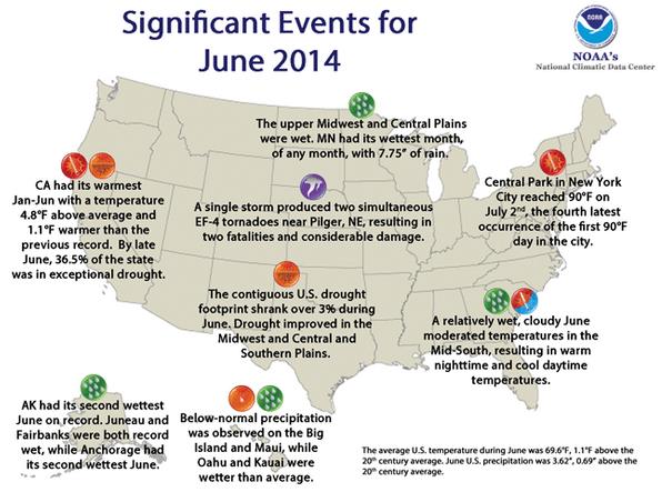
Significant Weather Events in June, 2014. Here's an excerpt of a good summary at
NOAA NCDC:
- The June national precipitation total was 3.62 inches, 0.69 inch above the 20th century average, marking the sixth wettest June on record, and the wettest since 1989.
- A significant portion of the contiguous U.S. — parts of the Northeast, Southeast, Midwest, and the Great Plains — had above-average precipitation during June. Eight states had one of their 10 wettest Junes on record, with Minnesota being record wet for the month. The 7.75 inches of precipitation averaged across Minnesota was 3.64 inches above the 20th
century average, marking the wettest month of any month for the state,
surpassing July 1897 and June 1914 when 7.32 inches of precipitation was
observed. In Canton, South Dakota, 19.65 inches of
precipitation fell during June, setting a new record among all months
for any location in the state, according to the South Dakota State
Climatologist...
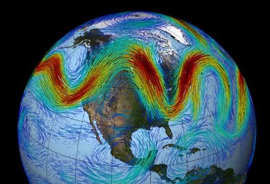
Waves In The Atmosphere Fueling More Extreme Weather.
Is climate change and rapid warming of the Arctic responsible for a
higher-amplitude jet stream pattern? The jury is out, but evidence is
mounting that there may be a link. Here's an excerpt of a story at
The Ventura County Star: "...
The
Arctic is warming twice as fast as areas around the equator because of
unique feedbacks involving ice cover in the region. The research argues
that as the temperature gradient between the poles and the equator
decreases, planetary waves are getting out of whack and becoming even
more extreme, though other research has challenged those findings.
Screen's study, however, only looked at the relationship between waves
and extreme events rather than any long-term shift in trends..." (Image credit: NASA).
Security Camera Footage of Pilger, Nebraska Tornado.
If you want evidence of what an EF-4 strength tornado is capable of,
and how fast things can go from normal to (bomb blast) check out this
YouTube clip from Farmer's Co-op store in Pilger during the (twin) June 18, 2014 tornado. Surreal.
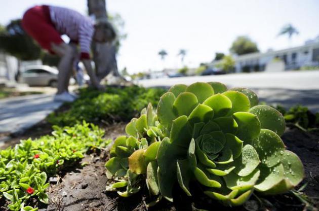
California Expected to Set Mandatory Water Curbs.
The Wall Street Journal
reports on the implications of an historic and deepening drought
impacting California and much of the western USA; here's a clip: "
California
is poised to institute mandatory statewide water restrictions for the
first time, as the impact of a three-year drought continues to spread
across the Golden State. The emergency measure expected to be approved
Tuesday by the State Water Resources Control Board comes as reservoirs
in California and elsewhere in the West have shriveled amid one of the
worst droughts on record to hit the region...."
Photo credit above: "
A
woman works among drought-tolerant plants in her front yard Wednesday,
July 9, 2014, in San Diego. Wasting water outdoors amid the state's
drought will begin hitting Californians in the wallet under new
restrictions being proposed by state regulators, with fines of up to
$500 a day for overwatering front lawns or washing a car without a
nozzle on the hose." (AP Photo/Gregory Bull)
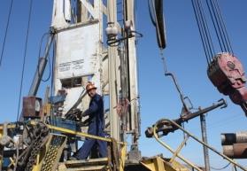
Drought Drives Drilling Frenzy for Groundwater in California. Here's the introduction to a story about siphoning water out of California's dwindling acquifers at
wbez.org: "
The
drought in California may be thousands of miles away, but it’s having a
direct effect on the rest of the country, including the Great Lakes
region. As part of our Front & Center series, we’ll be reporting on
that all week. But first we take you back to California, which grows nearly 50 percent of the nation’s produce.
The situation for farmers and ranchers has become so dire there’s a
potentially dangerous drilling boom going on. Not for oil or gas. For
water..."
Photo credit above: Sasha Khokha/KQED. "
Juan de La Cruz operates a drilling rig probing for groundwater 2,500 feet beneath Fresno County."
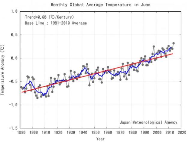
Hottest March-June on Record Globally, Reports Japan Meteorological Agency. This, without predicted El Nino warming kicking in (yet). Here's an excerpt from
Think Progress: "...
You may recall that the Japan Meteorological Agency (JMA) reported last month that March-May was the hottest in more than 120 years of record-keeping. Well, the JMA reported Monday
that last month was the hottest June in more than 120 years of
record-keeping. That makes 3 straight record-breaking months for JMA —
the hottest second quarter on record. It also means we had the hottest
March-June on record..."
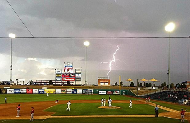
Lightning Could Kill Dozens At A Sports Venue: The Importance of Prevention.
Capital Weather Gang
(part of The Washington Post) tackles an important topic - a general
state of apathy when it comes to lightning from thunderstorms in crowded
stadiums, many of which "ride out the storm" and fail to evacuate fans
when skies turn threatening. Here's an excerpt: "...
He also
explained that isolated, severe thunderstorms tend to produce the
dangerous side flashes that can send lightning over 10 miles outside of
the parent thunderstorm. Those lightning flashes are particularly
dangerous for sports venues because they occur outside of the storm’s
rain shaft. What would happen if one of the largest lightning flashes, a
super bolt, hit inside of a stadium during an NFL game? The results
could be catastrophic if the stadium had not been properly evacuated
before the storm..."
Photo credit above: "
Cloud-to-ground strike behind a Texas League baseball game in Midland, TX." (Brian Curran, NWS Midland/Odessa, TX).
2014 Natural Disaster Damage And Death Toll Well Below Average. Here's a little good news courtesy of the
Environmental News Network,
but it's worth remembering that hurricanes, cyclones and typhoons often
result in the most significant impacts; peak season is late summer into
autumn. Here's an excerpt"...
During the first half of the year,
2,700 people died as a result of natural catastrophes, which was much
lower than is normal during the first six months of a year (10-year
average: 53,000). There were around 490 loss-relevant natural
catastrophes. The highest economic losses arose in the USA (35%),
followed by Europe and Asia (30% each). "Of course, it is good news that
natural catastrophes have been relatively mild so far", said Torsten
Jeworrek, Munich Re's Board member responsible for global reinsurance
business. "But we should not forget that there has been no change in the
overall risk situation..."
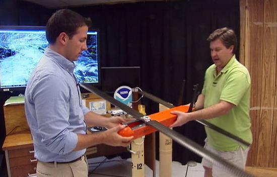
Hurricane Hunter's New Tool: Drones.
My Fox Tampa
has an interesting story about the latest tool in the National
Hurricane Center's data arsenal: drones - capable of flying for extended
periods near the raging surface of the ocean below, gathering more data
about the interface between ocean and atmosphere. Here's a clip: "...
To stay safe, Hurricane Hunter planes
typically fly through storms near 10,000 feet. Unmanned drones fly at
just a few hundred feet above the sea, eliminating the human and
financial risks. "It's designed to fly around for about 1.5 to two hours
down near the sea surface and measures the temperature and pressure and
humidity near the sea surface, where it's difficult and dangerous for
the manned aircraft to fly," meteorologist Eric Uhlhorn said at NOAA's
Hurricane Research Division in Miami..."
Do Sharks Help Predict Hurricanes? An unlikely headline, but there may be method to the madness after all.
WFTV.com has an interesting story; here's a clip: "...
Researchers
found that tracking the behavior of sharks and fish can help predict a
hurricane before it forms. "The behavior of fishes is so tied to ocean
atmosphere it's uncanny," said Ault. Researchers at the school have
attached about 1,000 tiny probes to sharks and tarpon in the waters
across the Florida peninsula. Their goal is to attach about 1,000 more
at a cost of $6,000 apiece. The magic number for storms to form happens
to be 79 degrees. The cutting-edge technology found that sharks and
tarpon flock to the same 79-degree waters..."
File photo: AP Photo/NOAA, Greg Skomal.
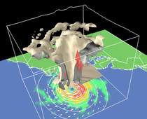
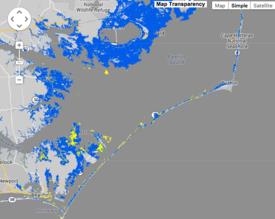
New Storm Surge Forecast Maps Enhanced Preparedness for Hurricane Arthur.
Scientific American explains how the availability of these surge forecasts from NOAA NHC helped to set expectations; here's a clip: "...
The
real measure of success, according to North Carolina governor Pat
McCrory at a July 4 news conference, was that there were no known deaths
or even serious injuries linked to the storm. “That puts a smile on all
our faces,” he said. And one of the major reasons for this, according
to Rhome, could have been the availability of the storm surge maps. The
governor ordered a mandatory evacuation for several parts of the state,
including the Outer Banks, where Arthur’s surge was predicted to reach
over 1.5 meters in some locations..." (Map: NOAA NHC).
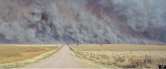
U.S. Wildfire Policy Inadequate, Senators Agree.
As the west continues to warm and dry wildfires are becoming more
pervasive, persistent and severe. And there isn't enough money to cover
the costs of fighting these blazes. Here's an excerpt from
9News in Washington D.C.: "...
Congress
must find a better way to pay to fight wildfires because rising costs
are limiting the government's ability to do preventive work before fire
season, a bipartisan group of senators said Tuesday. But Democrats and
Republicans disagreed on the solution..." (File photo: AP).
Facebook No Friend to Weathercasters. A story from Diana Marszalek at
TV NewsCheck
made me realize the fundamental (self-imposed) limitations of reaching a
large audience during an emergency via Facebook. Note to self. Twitter
doesn't discriminate. here's a clip: "
Many TV meteorologists have a
big gripe with Facebook after being caught off-guard by a change in
policy that hampers the reach of their vital weather alerts. According
to the weathercasters, people who follow someone’s professional Facebook
page don’t automatically get their posts in their newsfeeds, the way
they would a friend’s. Instead, Facebook determines who gets what using a
complex algorithm, essentially shutting most people out. Companies can
pay to boost their reach, but even then, the broadcasters say, they
still would reach very few of their followers..."
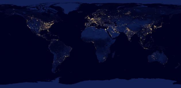
This Is What Political Patronage Looks Like From Space. Here's an excerpt of a curious story from
Quartz: "...
Political
favoritism in poor countries is visible from outer space. That’s what
nighttime shots taken from the International Space Station and other
satellites show, according to a new study.
In regions where electricity is scarce, towns that were the the
birthplace of the country’s political leader will shine the brightest at
night..." (Image credit: NASA).
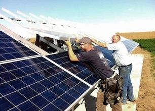
Electric Cars Will Change The Way You Power Your Home.
Time Magazine has the article that caught my eye; here's a clip: "...
The
most striking data was from EV owners who also had solar panels. From 7
a.m. to midnight, they used about one-fourth as much power from the
grid as the typical household, because they were getting power from
their rooftops and often selling power back to the grid. In other words,
they took very little from the grid when demand was high — at times
even helping to increase supply — and took much more from the grid when
demand was low. They helped smooth out demand..."
Image credit above:
Tesla Motors.
Leased Solar Panels Can Cast a Shadow Over a Home's Value. Do solar panels help or hurt your home's value when you go to sell it?
NPR has an interesting story - here's an excerpt: "..
.If
you're in a market where the market participants — the buyers in the
market — don't understand solar leases and they're fearful of it, they
may totally steer away from homes with a leased system," she says.
Today, it's difficult to determine whether a particular house with
leased solar panels is worth less, Adomatis says. There just isn't a
long history of sales involving such houses..."
Image credit: Solar Green Tech Media.
The Science of Cool.
Fast Company asks: what makes one consumer design cool, and another not cool? Here's an excerpt of an interesting analysis: "...
So
what is it, exactly, that makes one design cooler than another? The
difference is surprisingly tough to articulate. You might say it's
because the bottle on the right is unconventional. But a water bottle
shaped like a kangaroo would be unconventional, too, and you wouldn't
necessarily consider it cool. There's more to it than just being
different. A lot more, actually. Behavioral scientists have spilled
quite a bit of empirical ink on what makes something cool. They've
basically whittled the phenomenon down to four main traits..."
Photo credit above: Journal of Consumer Research.
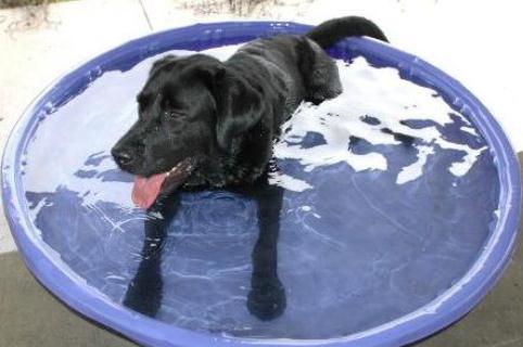
"The Sky is Falling!" Storm Anxiety in Pets.
Just like people, many pets seem to suffer from a weather-related
version of high anxiety during stormy periods; here's some useful
information from a story at
NBC Miami: "...
Like pets who deal with fireworks phobia,
storm phobic pets need a safe space to ride out the event. Unlike
fireworks, however, storms can be unpredictable, and often occur when
owners are not at home. A closet can make for an ideal safe space, as
they are dark, cozy, and insulated with hanging clothes. A crate covered
with a blanket and lined with bedding is also a great choice. Cats will
often find their own safe space and retreat to it as needed, but dogs
usually need a little more help from us. If you are home during a storm,
take him to the safe space and stay with him if you can. If he chooses a
different one, that is okay too! Reward his initiative with lots of
praise and positive re-enforcement..." (Image: FEMA).
Yes, Our Pets Really Do Make Us Happier.
Huffington Post has a great infographic that confirms what those of us with pets already know; here's an excerpt: "...
Happify,
a website dedicated to helping people build skills for happiness
through science-based activities and games, put together this infographic showing all the ways pets are good for our mental and emotional well-being. Take a look, and then go hug Fido!..."
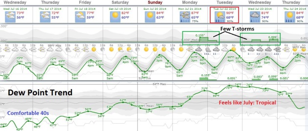
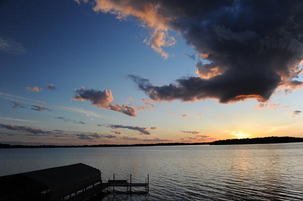
TODAY: Cool, clean sun, less wind. Dew point: 48. Winds: NW 8. High: 74
WEDNESDAY NIGHT: Clear and comfortably cool. Low: 56
THURSDAY: Plenty of sun, milder. High: 77
FRIDAY: Partly sunny, thawing out. Dew point: 56. Wake-up: 59. High: 81
SATURDAY: Warm sun, lake-worthy again. Wake-up: 63. High: 83
SUNDAY: Hazy blue sky. Sticky. Dew point: 60. Wake-up: 65. High: 86
MONDAY: Tropical, few T-storms likely. Dew point: 67. Wake-up: 66. High: 85
TUESDAY: Partly sunny, sticky and almost hot. Dew point: 69. Wake-up: 68. High: 88
Climate Stories...
Military Bases Face Hurdles in Climate Change Adaptation.
Climate Central has the story; here's the introduction: "
The
Department of Defense has 7,600 military installations across all 50
states and 40 foreign countries. They perform diverse functions, but
they have one thing in common: climate change could cost them big in the coming decades unless adaptation measures are taken soon. The military has already taken some action. Planning for climate change impacts is being folded into base Master Plans
around the world. And renewable energy projects have popped up on a few
installations, reducing greenhouse gas emissions and providing power
separate from the grid..."
Image credits above: U.S. Air Force. "
A lakebed used as an emergency runway at Edwards Air Force Base inundated by floods didn't dry out completely for 8 months."
Taking To The Pulpit Against Climate Change. USA TODAY
has an interesting article about climate change and Creation Care,
resonating with religious faith and spiritual values of stewardship;
here's an excerpt: "...You have to know who your audience
is," says Hayhoe who speaks at churches, evangelical colleges and
conferences, half of them from red states. "I know what people are
thinking. I know what many of their questions are. I know what they've
been hearing." She answers their doubts even before they are raised. But
more importantly, Hayhoe says, "I start out by sharing not from my
head, but from my heart — what my own values are and why I care about
this issue." Spiritual common ground on this issue is absolutely
necessary, Hayhoe and others say..."
When Climate Change Floods Your Heart.
We can talk about statistics, models and a blur of scientific papers,
theories and projections, but in the end the mere idea that what we are
doing, what we have done, might have an impact on the planet, can be the
source of denial, depression, dread, anxiety and outright fear. How we
do move forward? Here's an excerpt of an Op-Ed that hit home at
The New York Times: "...
The
metaphor of physical displacement feels like an apt one for what
appears to be happening to our weather: The places we live are not what
they once were. While politicians debate the existence of climate change
(or, increasingly, move on to debating whether to do anything about
it), other narratives are just starting to get attention: Those that
deal with how it feels when what we once relied on — the length of the
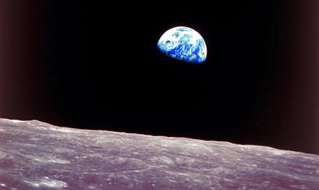
winter, say, or the depth of a river — seems to shift around us....” (Apollo 8 File Photo: NASA).
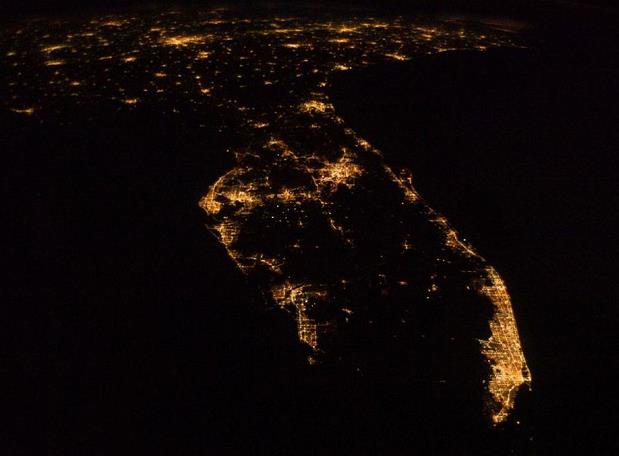
Miami, The Great World City, Is Drowning While The Powers That Be Look Away. South Florida is among the most vulnerable areas in the USA for sea level rise. The Guardian takes a look at recent trends; here's an excerpt: "...What makes Miami exceptionally vulnerable to climate change
is its unique geology. The city – and its satellite towns and resorts –
is built on a dome of porous limestone which is soaking up the rising
seawater, slowly filling up the city's foundations and then bubbling up
through drains and pipes. Sewage is being forced upwards and fresh water
polluted. Miami's low topography only adds to these problems. There is
little land out here that rises more than six feet above sea level. Many
condos and apartment blocks open straight on the edge of the sea. Of
the total of 4.2 million US citizens who live at an elevation of four
feet or less, 2.4 million of them live in south Florida..." (Image above: NASA).
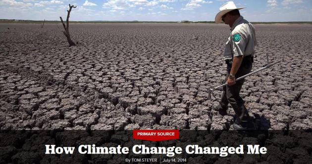
How Climate Change Changed Me. Here's an excerpt of an Op-Ed from Tom Steyer at
Politico: "..
.Let
me be clear—climate change is bigger than any one person. I believe it
is truly the most pressing issue we face, and one that if not addressed
will have profound consequences for our kids. As a very senior and very
conservative investor friend told me, “You never put the entire
enterprise at risk. That’s bad business.” And yet, that’s what our
society appears to be doing...."


No comments:
Post a Comment