85 F. high on Thursday in the Twin Cities.
84 F. average high on July 10.
83 F. high on July 10, 2013.
.31" of rain predicted for MSP by Saturday evening (NAM model).
All-Star Cliche
How
often have you heard the following: "Oh, you live in Minnesota - it's
really cold there huh?" I usually nod in agreement, then show them my
polar bear tattoo, which makes them want to change the subject.
I
would bet a small, well-equipped Winnebago that FOX-TV announcers will
chat about "Minnesota's ridiculously chilly weather" during Tuesday's
MLB All-Star game, reinforcing the tired stereotypes we've all grown up
with.
According to meteorologist D.J. Kayser if the first
pitch temperature is colder than 68F at Target Field it'll be the
chilliest All-Star game since 1980. It'll be very close.
If
you're connecting the dots and tracking the trends early next week will
be more evidence that the jet stream is seriously misbehaving; knocked
out of alignment. Monday may be 20-25F cooler than average here, but
30-35F warmer than average over western Canada. More crazy extremes.
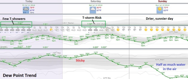
A few T-storms today give rise to 80s with some sun tomorrow (and a few more storms). Soak it any attempted warmth,
because we start to cool off Sunday. Monday will feel like football
weather: scrappy clouds and PM showers, 50s north and 60s south.
You may not believe me (I'm OK with that) but Monday morning there's a 60 percent chance you'll reach for a jacket.
MLB All-Star Weather Factoids. From Media Logic Group meteorologist D.J. Kayser:
Weather conditions for first pitch are available from official box scores on
Baseball Reference.
A good note, not every box score lists weather conditions. The vast
majority have it, however, since the League Divisional Series started in
the 90s. I went back to 1980, and the weather listed for the start of
the game is included (if it wasn't "Unknown") in the attachment.
Since 1980, there have been 4 games with
documented starting weather that had a gametime temp of 68°
- 1990 - Wrigley Field (Chicago)
- 1999 - Fenway Park (Boston)
- 2002 - Miller Park (Milwaukee)
- 2007 - AT&T Park (San Francisco)
Since 1980, there have been no documented games with a gametime temp of below 68°.
Weekend Meteogram.
Expect more scattered showers and T-storms today and Saturday as dew
point rise thru the 60s. Winds swing around to the northwest Sunday; the
sunnier, drier, cooler day of the weekend as temperatures sink into the
40s - meaning less than half as much water in the air than Saturday.
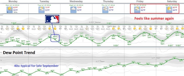
Summer Siesta.
The first few days of next week will feel more like late September than
mid-July. Monday will be the chilliest day; highs in the low to mid 60s
with scrappy clouds and PM instability showers. Gametime temperatures
for the MLB All-Star game will be in the mid 60s after a Tuesday high
near 70. The good news: summer stages a comeback by the end of next week
- 80s return next weekend.
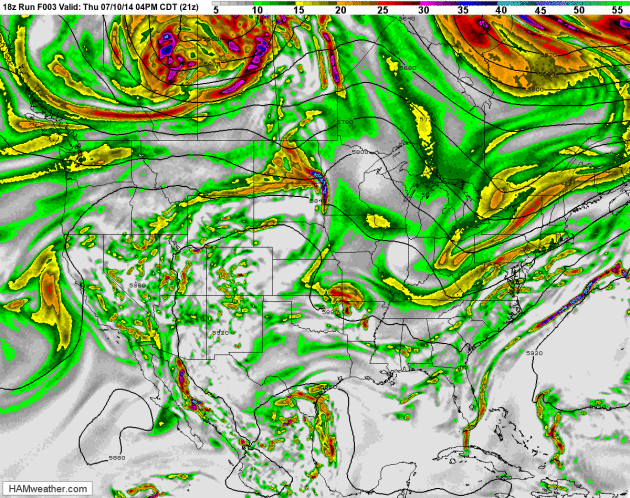
Arthur's Revenge?
One theory circulating among meteorologists. A powerful cyclonic flow
around ex-hurricane Arthur (which plowed into the Canadian Maritimes)
helped to dislodge unusually chilly air and push it southward towards
the USA. That's a plausible theory, but there's now little doubt that
jet stream winds will buckle, allowing potentially record-setting chill
to pour southward early next week. Typical for early October, but a
little unusual for the dead of summer. 500 mb winds: HAMweather.
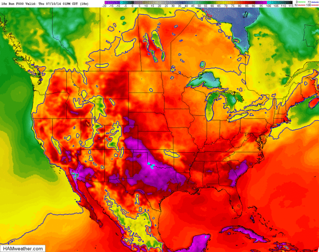
2-Meter Temperature Outlook.
NOAA's NAM model shows highs topping 100F over the central and southern
Plains, at the same time 50-degree air surges south across Manitba,
treating much of the Upper Mississippi Valley to a bout of rare,
mid-summer sweatshirt weather by Monday.
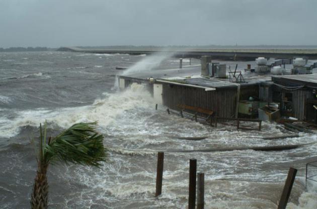
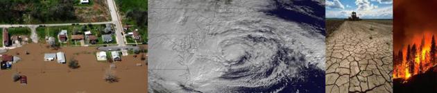
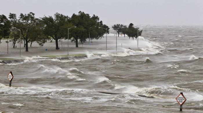 Exclusive: Coastal Flooding Has Surged In U.S., Reuters Finds
. Here's an excerpt of an eye-opening story from Reuters at
The Chicago Tribune: "...
During
the past four decades, the number of days a year that tidal waters
reached or exceeded National Oceanic and Atmospheric Administration
flood thresholds more than tripled in many places, the analysis found.
At flood threshold, water can begin to pool on streets. As it rises
farther, it can close roads, damage property and overwhelm drainage
systems. Since 2001, water has reached flood levels an average of 20
days or more a year in Annapolis, Maryland; Wilmington, North Carolina;
Washington, D.C.; Atlantic City, New Jersey; Sandy Hook, New Jersey; and
Charleston, South Carolina. Before 1971, none of those locations
averaged more than five days a year. Annapolis had the highest average
number of days a year above flood thresholds since 2001, at 34..."
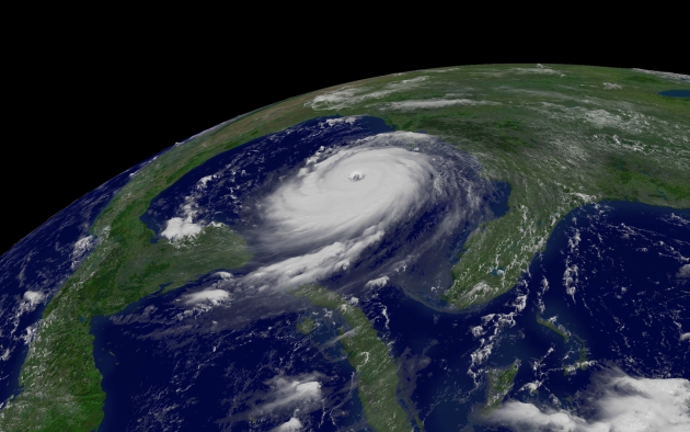
Hurricane Storm-Surge Risks to Property Rise on Atlantic, Gulf Coasts, Study Finds. Here's the intro to a story at
The Wall Street Journal: "
More
than 6.5 million homes along the Atlantic and Gulf coasts are at risk
of hurricane storm-surge damage, with New York City having the most
homes and value at risk, according to a new report released Thursday by a
company that analyzes property values. The study by CoreLogic found
that the vulnerable homes represent $1.5 trillion in potential
reconstruction costs, with nearly two-thirds - $986 billion - of that
risk concentrated in 15 metro areas..." (File image: USGS).
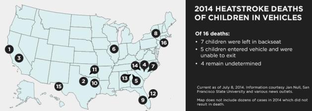
Map: Every U.S. Hot Car Child Death in 2014.
HLNtv.com
has details on every one of the 16 hot weather-related child deaths in
the USA so far this year. It's worth reminding (everyone) that you can't
leave kids in a hot car, even for a minute or two, this time of year.
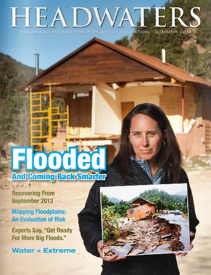
Flooded and Coming Back Stronger. I came across an amazing article about last year's devastating flood in Boulder, Colorado that's worth a look. Check it out in
Headwaters: Colorado Foundation for Water Education.
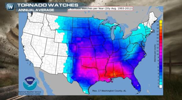
Tornado Alley Migration?
Traditional Tornado Alley runs from Texas to Iowa, but in recent years
NOAA SPC has issued the most Tornado Watches for southern Alabama and
Mississippi, the same area that has the highest tornado concentration
and death toll. Not quite what I was expecting, and it's the topic of
today's first
Climate Matters segment.
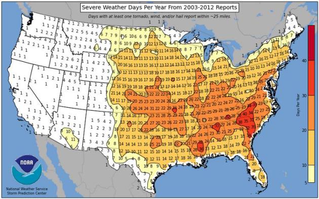
Severe Storm Capital of the USA Since 2003: Asheville, North Carolina?
I know, I did a double-take too, and 10 years may not be a long enough
time to derive any meaningful statistical trends, but the Asheville area
receives nearly 40 days/year, on average, with a tornado, severe wind
storm or large hail within 25 miles of the city, according to NOAA SPC.
That compares with 25 in Atlanta, 21 in Dallas and Denver, 10 in Chicago
and roughly 16 in the Twin Cities. L.A. sees an average of 4 severe
weather days, with only 1 in the Bay Area and San Diego. Sign me up.
Source:
NOAA SPC.
The Severe Weather Capital of the USA Since 2003 is....North Carolina?
When, exactly, did that happen? The data set isn't very long (since
2003), but looking at tornadoes, large hail and damaging winds
Asheville, North Carolina sees more than 3 times more "severe weather
days" during an average year than Dallas or Wichita. That's the subject
of a second
Climate Matters segment: "
40
days a year of severe weather makes..... Asheville, NC the severe
weather capital of the United States? It's true. The Carolinas see
almost 40 days a year with hail and wind gusts over 50 mph. That's a bit
of a head scratcher."
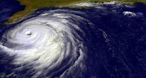
It's Hurricane Season. Too Bad The Fed's Aircraft Fleet for Tracking Them Is Kind Of A Mess. Jill Aitoro has the story at
The Washington Business Journal; here's a highlight: "...
So what’s the problem? As reported by the Government Accountability Office,
they’re overburdened. And they’re old. NOAA’s aircraft fly
approximately 3,800 to 5,200 flight hours per year. And although most
hurricane reconnaissance is conducted by Air Force aircraft, NOAA is
required to make its P-3 Orion aircraft available if the Air Force is
unable to meet the reconnaissance needs posed by severe weather events.
One of NOAA’s two operating P-3 Orion planes must be configured and
available to conduct reconnaissance each hurricane season from June 1 to
November 30, the GAO noted, and the other P-3 Orion must be available
from July 15 to Sept. 30. During these months, the P-3 Orion planes are
generally not available for other uses...."
File image: AP.
Voices: Floridians Get Complacent About Hurricanes.
It's been 9 years since a major, category 3 or stronger hurricane has
hit the U.S. coastline. At some point the law of averages catches up
with you. Here's a clip of an Op-Ed at
USA TODAY: "...
There
are several reasons why Floridians have adopted a more casual approach
to hurricanes in recent years. Part of it is a new wave of people moving
to the state who have no experience with hurricanes or typhoons or
anything of the sort. About 1 million people have moved to Florida since
the last hurricane hit the state in 2005, according to the U.S. Census.
Another factor is how quickly people can forget painful events.
McCaughey likens it to childbirth: "We forget how much that hurts..." (Imagery: NASA).
Why New Orleans' Katrina Evacuation Debacle Will Never Happen Again.
Next City
has an interesting story focused on what New Orleans officials learned
in the wake of Superstorm Sandy; how they are much better prepared for
the next, inevitable hurricane. Here's an excerpt: "
In New Orleans,
evacuation requires decisions that must be made early before traffic
builds, motels fill up, roads flood, or winds reach dangerous levels. In
2005, when Katrina loomed in the Gulf, most New Orleanians did leave
town, but roughly 100,000 were left behind. Many lacked a car or money
for transportation, or had special needs that made evacuation
impossible. Others were stranded because they practiced “vertical
evacuation,” staying with family that lived on higher ground or renting
hotel rooms in buildings that had proven safe in the past. “We will
never do that again,” said Lt. Col. Jerry Sneed, the city’s deputy mayor
of Public Safety and Homeland Security..."
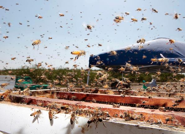
A Reason Millions of Bees are Dying.
The Washington Post reports; here's the intro: "
In the
past several weeks, a spate of studies have appeared in scientific
journals suggesting the culprit behind mass deaths of honeybees is
widely used pesticides called neonicotinoids. On June 23, President
Obama signed a memorandum establishing the first-ever federal pollinator
strategy and the Agriculture Department announced $8 million in
incentives to farmers and ranchers in five states who establish
new habitats for honeybees..."
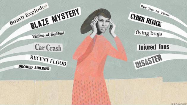
Bingeing on Bad News Can Fuel Daily Stress.
After reading the previous story about bees I'm kind of depressed. This
may not come as a shock (to anyone), but if you immerse yourself in a
steady drumbeat of negativity and gloomy news, it probably won't help
your stress levels. Here's a clip from
NPR: "
If
you're feeling stressed these days, the news media may be partly to
blame. At least that's the suggestion of conducted by NPR, the Robert
Wood Johnson Foundation and the Harvard School of Public Health. The
survey of more than 2,500 Americans found that about 1 in 4 said they
had experienced a "great deal" of stress in the previous month. And
these stressed-out people said one of the biggest contributors to their
day-to-day stress was watching, reading or listening to the news..."
Illustration:
Katherine Streeter for NPR.
TODAY: Showers and T-storms likely, few downpours. Winds: S 10. High: near 80
FRIDAY NIGHT: Another T-shower. Low: 67
SATURDAY: Some sun, sticky. T-storms late. Dew point: 67. High: 82
SUNDAY: More sun, drier - cooler breeze. Wake-up: 64. High: 79
MONDAY: Early October. Clouds, PM showers. Wake-up: 60. High: 67
TUESDAY: More clouds than sun. DP: 47. Wake-up: 53. High: 70
WEDNESDAY: Bright sun. Beautiful. Wake-up: 55. High: 74
THURSDAY: Fading sun, a bit warmer. Wake-up: 59. High: 77
Climate Stories....
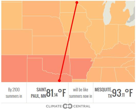
Global Warming Interactive. How Hot Will Your City Get? By
the end of the 21st century, if there is no concerted global effort to
reduce greenhouse gas emissions, summers may be unrecognizable across
muc of the USA, according to Climate Central and
InsideClimate News; here's an excerpt: "...
According
to the research, U.S. cities could be up to 12 degrees Fahrenheit
hotter than they are today by 2100. St. Paul, Minnesota could feel like
Dallas, Texas. Las Vegas could feel like places in Saudi Arabia, with
average temperatures of 111 degrees Fahrenheit. Phoenix could feel like
Kuwait City, one of the hottest cities in the world, with average
temperatures of 114 degrees Fahrenheit..."
Global Warming Creates Arctic Shipping Route Opportunity. Less ice up north? Here's one silver lining: we can ship stuff faster!
Euronews has the video and story; here's an excerpt: "
Japan’s Mitsui O.S.K. Lines says it going to run the first ever regular commercial shipping route through the Arctic Ocean. Starting in 2018 it plans to initially move liquefied natural gas from the huge LNG plant Russian is to build on the Yamal Peninsula to markets in Europe and Asia. In a joint venture with China Shipping, it will use three icebreakers, which have been ordered from South Korea’s Daewoo..."
Climate Change Solution: Scrap Subsidies, Fund Innovation.
Seems like a good idea to me, although we've been subsidizing dirty
fossil fuels for a long time, and continue to do so as a nation. Here's
an excerpt from
The Christian Science Monitor: "
Ahead
of next year's Paris climate talks, it's time for a new approach to
climate change that supports making clean energy cheaper than fossil
fuels without subsidies, writes Matthew Stepp of the Center for Clean
Energy Innovation. The only way to do that is with more innovation..."
Global Warming Requires More Frequent Rethink of "Normal" Weather: UN. No
kidding. As the weather becomes more volatile, responding to more
energy and heat in the atmosphere-ocean-cryosphere, we're going to see
more erratic swings in temperature and moisture. Here's an excerpt from
Reuters: "
The
baseline for "normal" weather used by everyone from farmers to
governments to plan ahead needs to be updated more frequently to account
for the big shifts caused by global warming, the U.N.'s World
Meteorological Organization said on Wednesday.
The WMO's Commission for Climatology believes rising temperatures and
more heatwaves and heavy rains mean the existing baseline, based on the
climate averages of 1961-90, is out of date as a guide, the WMO said in a
statement. "For water resources,
agriculture and energy, the old averages no longer reflect the current
realities," Omar Baddour, head of the data management applications at
the WMO, told Reuters..."
Climate Change: What Are The Risks to Corporations? Fortune has the details; here's an excerpt that caught my eye: "
Extreme
weather events appear to be getting more severe and more frequent, as
the recent drought in California and floods in Europe reminded us.
Weather events accounted for 90% of natural catastrophe losses in 2013,
causing over $120 billion of losses, according to reinsurance company
Munich Re. In 2012, the overall effect of climate events on the US and
European economies is estimated at more than $5 trillion for each
region, or over 30% of their GDP. The investment community – along with
regulators – has woken up to this threat. It is demanding more
information from companies about their exposure to climate events, as
well as the prospective cost of their carbon emissions..."
Saving Water in California.
California may be facing a slow-motion water disaster if El Nino-driven
rains don't arrive next winter (which is no sure bet). Here's a clip of
an Op-Ed from
The New York Times Editorial Board: "...
California
is in the third year of its worst drought in decades. But you wouldn’t
know this by looking at how much water the state’s residents and
businesses are using.
According to a recent state survey, Californians cut the amount of
water they used in the first five months of the year by just 5 percent, far short of the 20 percent reduction Gov. Jerry Brown called for in January. In some parts of the state like the San Diego area water use has actually increased
from 2013. Without much stronger conservation measures, the state, much
of which is arid or semiarid, could face severe water shortages if the
drought does not break next year..." (Image above: ThinkStock).


No comments:
Post a Comment