Minnesota Resilience
By Paul Douglas
By Paul Douglas
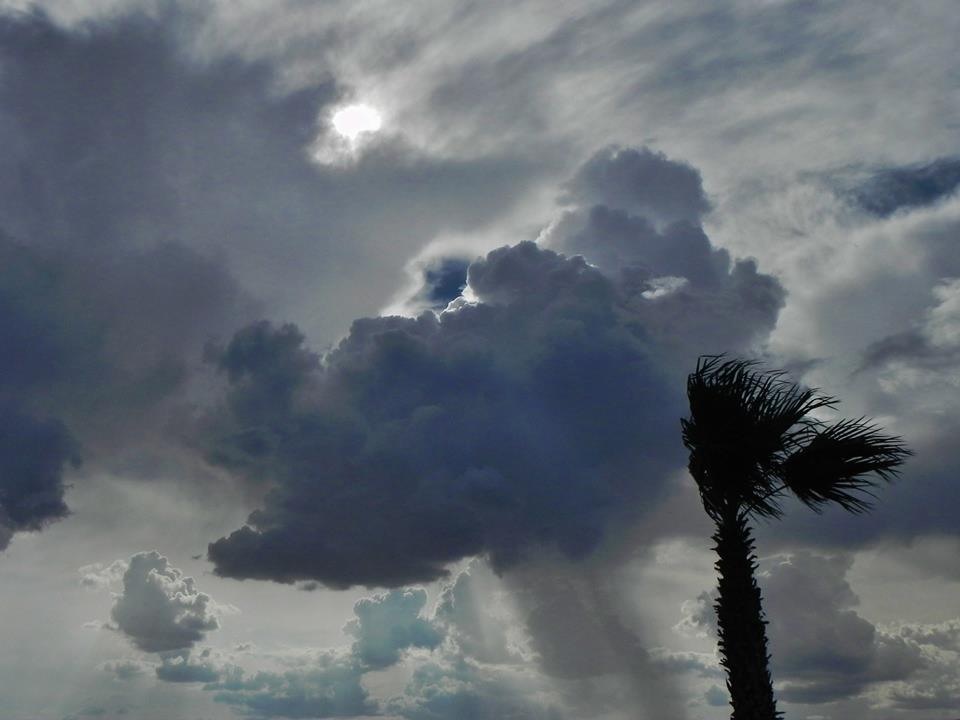
Mother Nature has her seat belt off. She's careening down the road, bouncing off the guardrails, fish-tailing and pressing down on the accelerator pedal, just like Thelma and Louise. Our weather is more volatile and no matter what the reason it's a risk, and an opportunity for Minnesota to reinvent itself as a sturdier, more resilient place to live and do business.
I spent much of the weekend on Pelican Lake searching for dock sections after last Monday's severe winds. We're going to need new species of trees able to withstand extreme weather. New hybrid strains of corn, wheat and beans, able to weather wilder swings from drought to flood and extreme summer humidity levels. City drainage systems will need to be re-engineered, hardened, hail-proof homes and cars, and new technologies that generate electricity and power the economy, without harmful carbon pollution.
A taste of early September keeps highs in the 70s with PM instability showers on Sunday. Canadian air drops dew points into the 40s & 50s the first half of the week, but you'll be able to work up a summer sweat by late week as highs push into the 80s.
I think my dock sections are in 3 different counties. Back to work.
===================
SATURDAY NIGHT: Partly cloudy, isolated T-storm possible. Low: 64
SUNDAY: September-like. Windy and cooler with PM showers. Winds: NW 15-25. High: 75
SUNDAY NIGHT: Lingering shower early. Calming winds overnight. Low: 59.
MONDAY: Blue sky & beautiful. Dew point: 51. High: 77
TUESDAY: Plenty of sun, still beautiful. Wake-up: 57. High: 79
WEDNESDAY: More sun. A few WI showers. Wake-up: 60. High: 80
THURSDAY: Mix of clouds. Late day T-Storm. Wake-up: 62. High: 81
FRIDAY: Hazy sun, feels like summer again. Wake-up: 63. High: 83
SATURDAY: Warm sun, lake worthy. DP: 60. Wake-up: 64. High: 84
======================
This Day in Weather History
July 27
July 27
1910: Giant hailstones in Todd and Wadena Counties. One stone weighed in at 5 pounds.
=====================
Average High/Low for MSP
July 27
July 27
Average High: 83°
Average Low: 64°
Average Low: 64°
====================
Moon Phase for July 27th at Midnight
1.3 days since midnight

=======================
Fishing Lake Michigan
Thanks to my good friend Matt Wilmes for this picture. Weather was pretty good for a weekend of fishing on Lake Michigan! Matt said they caught a lot of BIG fish... unless it was a fish tale?

Fishing Continues...
Thanks to another good friend of mine for these pictures who was able to capitalize on Saturday's nice weather in central Minnesota. Nice fish, though is it me or does it look like that bass has a piece of beef jerky hanging out of it's mouth?


BIG Changes Sunday...
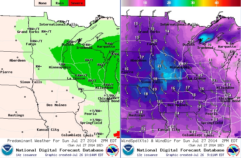
After a very summerlike Saturday, Sunday will feel a little more like fall with a near 15° temperature drop. A puddle of cold air aloft will swirl through the state for the second half of the weekend. A few wind blown rain showers may chase you indoors at times, but it doesn't look like a complete washout. The biggest nuisance may be the gusty winds... the image below shows weather conditions at 2pm Sunday: Temps in the low to mid 70s with a few spotty showers and gusty NW winds up to 25mph.
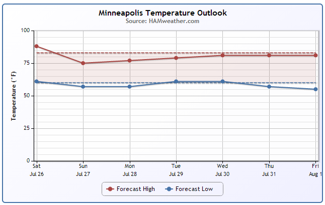
Minneapolis Temp Trend
As our next blob of cool air slides into the Great Lakes region, temperatures will drop into the 70s over the next couple of days, but we get back to near average by the middle part of the week. Might be another chance to save some $$$ on the A/C bill. Open those windows and let the fresh breeze through the house.
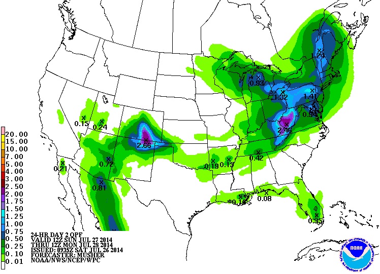
Sunday Precipitation
According to NOAA's HPC, there will be a little wrap around moisture across the Upper Mississippi Valley with the cold pool as it rotates through, but the best chance of heavy rain will shift into the Ohio Valley and Eastern U.S.. Heavy rainfall and severe weather will make for a very active day in that part of the country. There will also be some heavy rainfall across the Front Range of the Rockies.
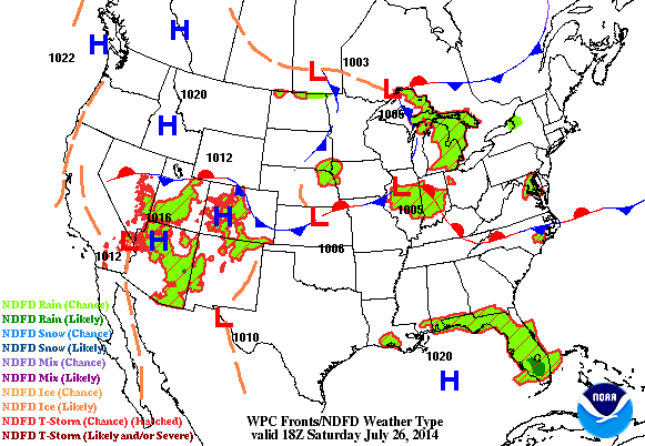
Stormy Sunday
A fairly impressive wave of energy will continue to move through the northeastern part of the country through early next week. In its wake, strong the severe thunderstorms will tear through portions of the Ohio Valley and the eastern U.S. with hail and high winds and isolated tornadoes.
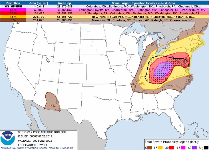
Sunday Severe Threat
There is a significant severe threat on Sunday from portions of the Ohio Valley to the Eastern Seaboard with tornadoes, damaging winds and large hail all possible. Read more from the Storm Prediction Center:
TORNADOES...DAMAGING WINDS AND LARGE HAIL ARE EXPECTED ACROSS MUCH OF EASTERN KENTUCKY...SOUTHERN OHIO AND WEST VIRGINIA DURING THE AFTERNOON AND EVENING. SEVERE WEATHER IS ALSO EXPECTED ACROSS MUCH OF THE MID-ATLANTIC AND NORTHEASTERN STATES WITH MAINLY DAMAGING WINDS AND HAIL. ISOLATED HAIL AND WIND IS ALSO POSSIBLE ACROSS SOUTHEASTERN ARIZONA. ...SYNOPSIS... AN IMPRESSIVE UPPER TROUGH WILL DIVE SEWD FROM THE UPPER MS VALLEY INTO THE OH VALLEY ON SUNDAY WITH MID TO UPPER LEVEL WINDS INCREASING TO 60-90 KT RESPECTIVELY. AT THE SURFACE...THE PRIMARY SURFACE LOW WILL TAKE SHAPE FROM LOWER MI INTO OH DURING THE DAY...WITH SURFACE TROUGH/FRONT FROM OH SWWD ALONG THE OH RIVER. PRECEDING THE COLD FRONT WILL BE CLUSTERS OF STORMS...PERHAPS A SEVERE MCS...OVER SRN OH/WV/ERN KY IN THE MORNING...AND THIS MAY AFFECT VA LATER IN THE DAY. OUTFLOW FROM THIS POTENTIAL MCS MAY AID TORNADO POTENTIAL ACROSS THE MDT RISK AREA LATER IN THE DAY WHEN WSWLY SURFACE WINDS AND COOLING ALOFT STRONGLY DESTABILIZE THE AREA. TO THE E...A SURFACE TROUGH WILL ALSO DEEPEN E OF THE APPALACHIANS WITH S WINDS BRINGING ATLANTIC MOISTURE NWD ACROSS THE DELMARVA AS WELL AS INTO SRN NEW ENGLAND DURING THE DAY. AN UPPER-LEVEL DISTURBANCE MAY AID IN RELATIVELY EARLY SEVERE STORM DEVELOPMENT FROM ERN NY INTO SRN NEW ENGLAND WITH A SECOND ROUND OF STORMS OCCURRING OVERNIGHT.
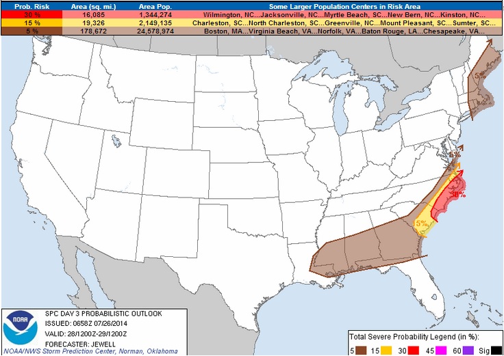
Monday Severe Threat
It'll be an active start to the work week as ongoing thunderstorms continue to roll east through the Eastern Seaboard.
SCATTERED SEVERE STORMS CAPABLE OF LARGE HAIL AND DAMAGING WINDS APPEAR LIKELY ACROSS THE FAR EASTERN CAROLINAS AND ACROSS EXTREME SOUTHEASTERN VIRGINIA. AN ISOLATED WIND THREAT MAY EXIST ACROSS NEW ENGLAND EARLY...AND A FEW SEVERE STORMS ARE POSSIBLE ACROSS THE CENTRAL GULF COAST STATES.
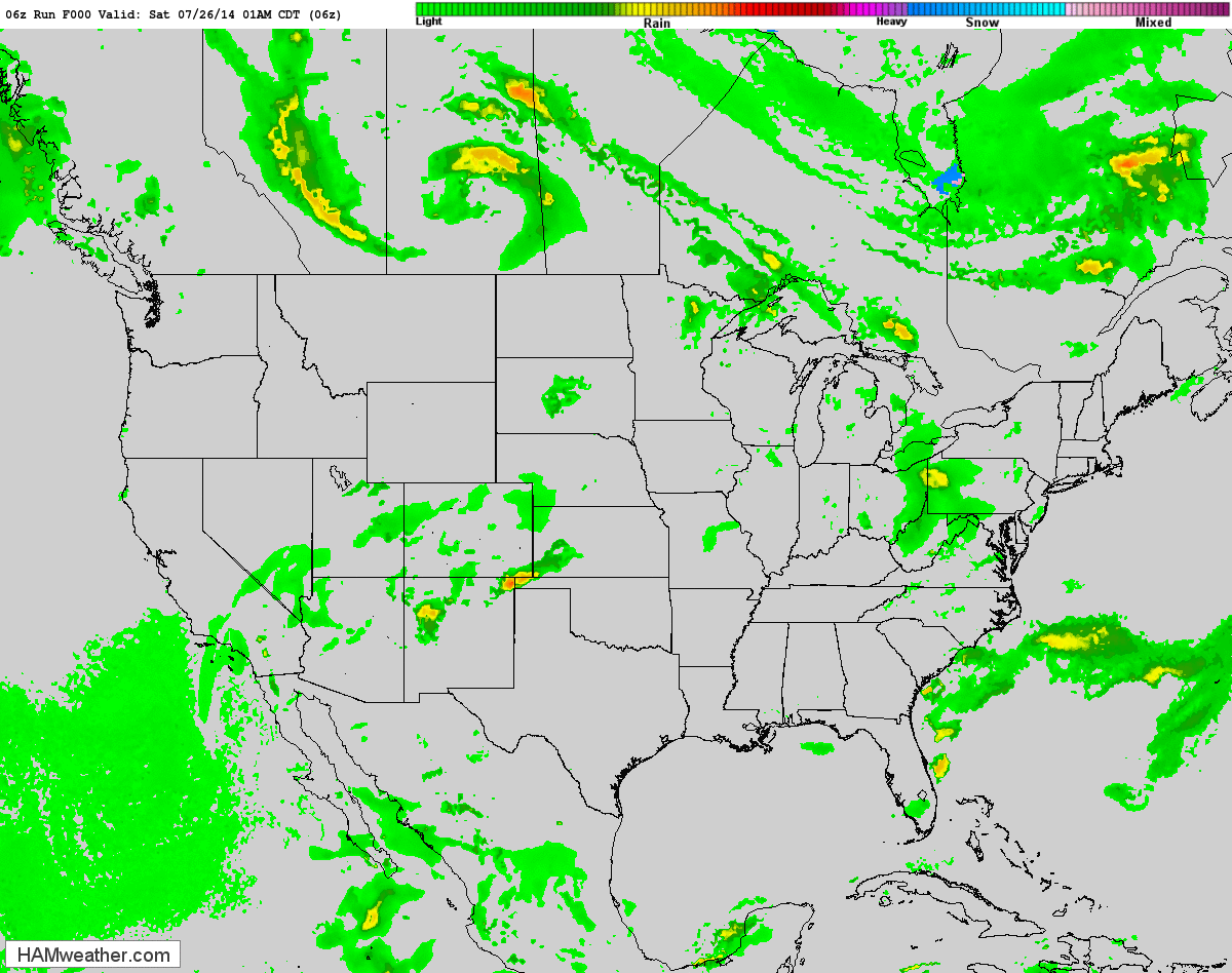
Radar Simulation
The simulated radar for Sunday and Monday shows a fairly active weather scenario unfolding in the areas highlighted in the risk areas above
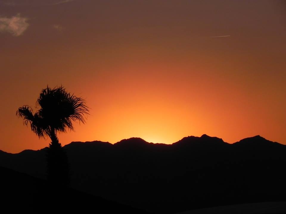
Arizona Images
My good friend Rich Koivisto out of Bullhead City, AZ shared these pictures with me... He is a very talented photographer and loves capturing the desert beauty! Monsoon season is well underway in the Desert Southwest. Thunderstorms have been popping up nearly every day and some of them have been responsible for flooding rains, damaging winds and dust storms. Lightning can also be an issue with additional wildfire concerns.
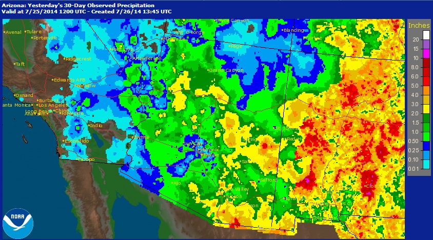
Arizona Monsoon Season
The Arizona Monsoon Season runs from June 15th to September 30th and interestingly, parts of Arizona see nearly half of its annual average precipitation during this time frame! The image below shows radar estimated rainfall over the past 30 days. Note that some of the estimates in eastern Arizona suggests nearly 5" of rain or more!
Phoenix, AZ Stats
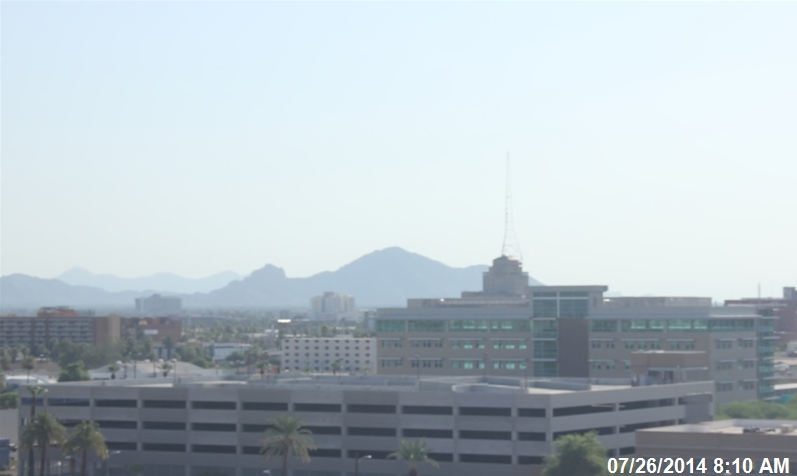
The image below from Saturday morning in Phoenix, AZ showed a fairly hazy view of Camelback Mountain. Keep in mind that it's usually quite dry in the Southwest, but early Saturday morning, the dewpoint was in the mid 60s in Phoenix... yea, that's pretty muggy! Phoenix had 2 record highs this week; 114F on Wednesday and 116F on Thursday. Phoenix, by the way, has only seen 0.06" of rain so far this month (thru July 25th), which is 0.74" below average. For the year, Phoenix has only see 1.05" officially, which is nearly 3" below average!
(Image courtesy: PhoenixVis.net)
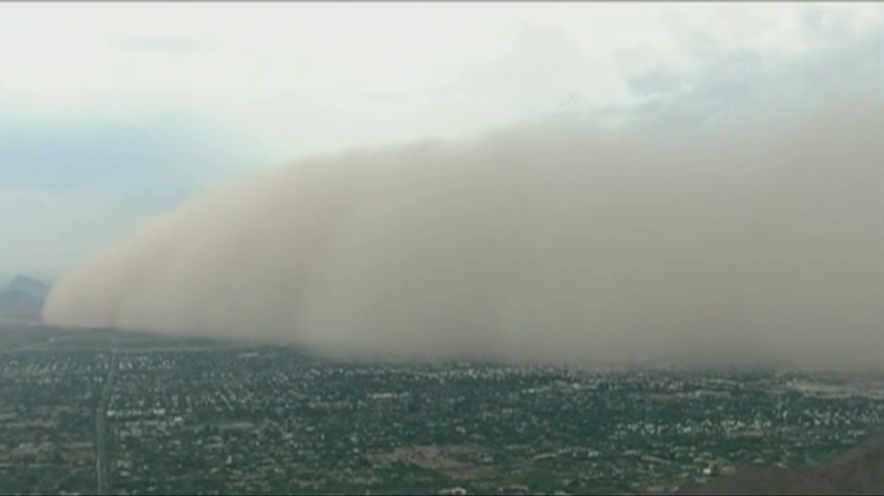
Monsoon Dust Storms
Check this out... a massive dust storm blew through the Phoenix area on Friday from thunderstorm outflow winds. Several thousand people lost power and there was a temporary groundstop for incoming flights at the Phoenix International Airport due to the cloud of dust!
(Image Courtesy: USA Today - see the video HERE)
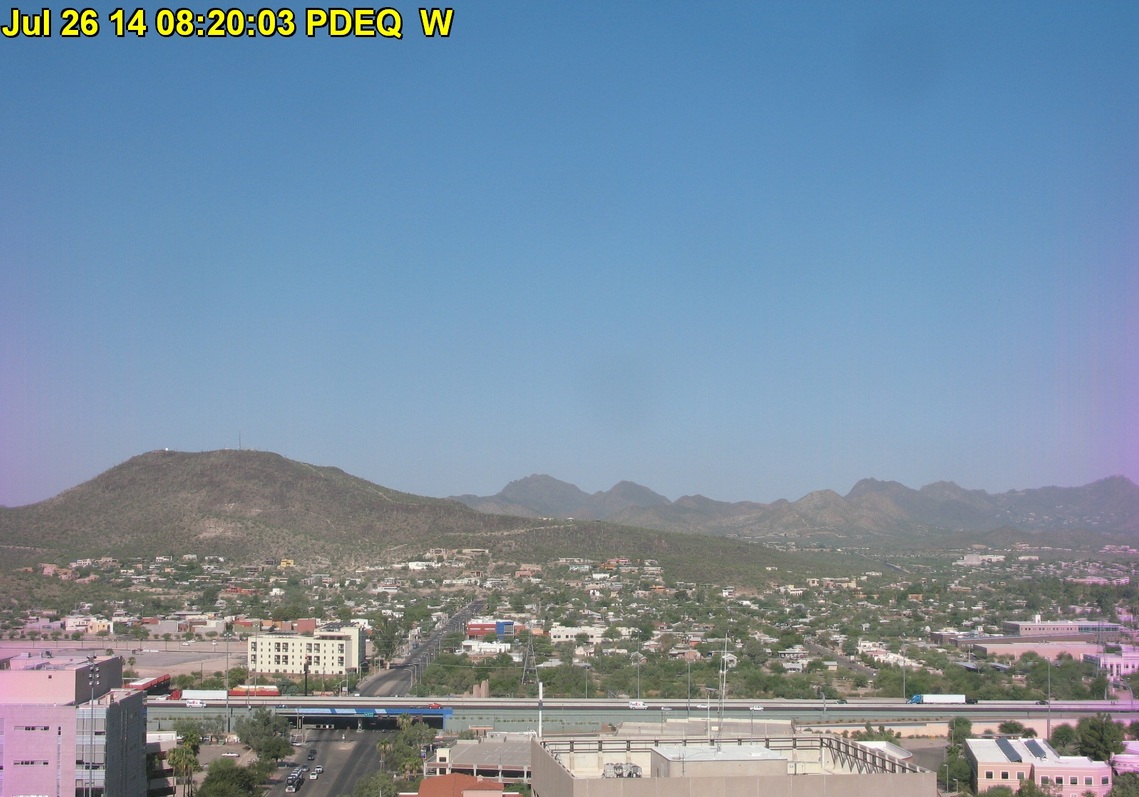
Tucson, AZ Stats
Tucson, AZ has seen 1.41" of rain so far this month (thru July 25th), which is 0.27" below average and has seen 2.02" this year, which is nearly 3" below average. The image below from Saturday morning in Tucson, AZ looked fairly quiet, but a little hazy as the dewpoint was hovering in the lower 60s.
(Image Courtesy: AirInfoNow.org)
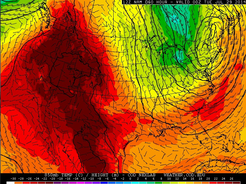
More Southwest Heat!
Our high amplitude weather pattern continues as large ridges and troughs have developed across the northern hemisphere. Note the big up and down swings in the jet stream from near Alaska through Canada and United States. The white line in the image below shows the jet stream, which is the dividing line between the hot and cold air. The big swings in this feature explain the big warm ups and cool downs across the country.
(850mb Forecast Temps for 7pm CDT Monday)
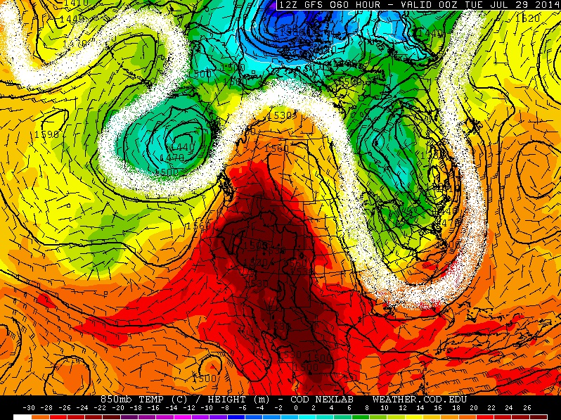
(850mb Forecast Temps for 7pm CDT Monday)
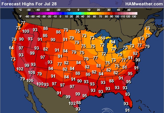
Forecast High Temps for Monday, July 28th
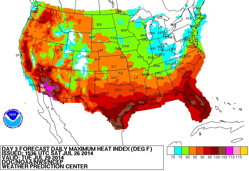
Forecast Heat Index for Tuesday, July 29th
The ridge of high pressure continues in the western U.S. through much of next week. Forecast Heat Index values on Tuesday could be as high as 105° - 115° in the Desert Southwest.
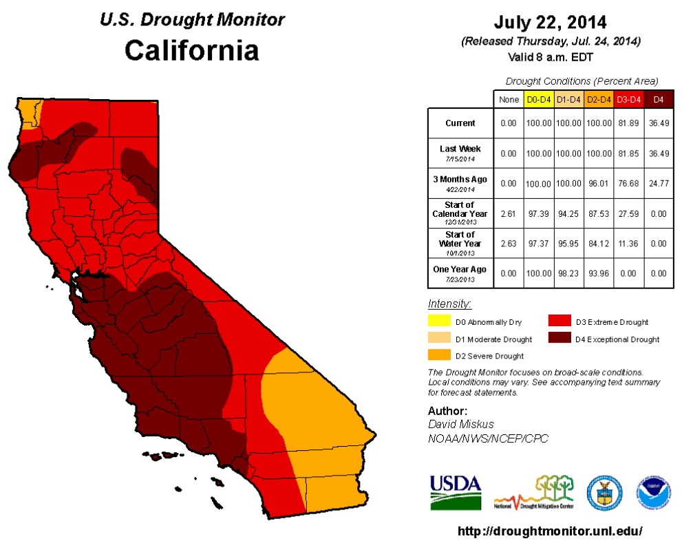
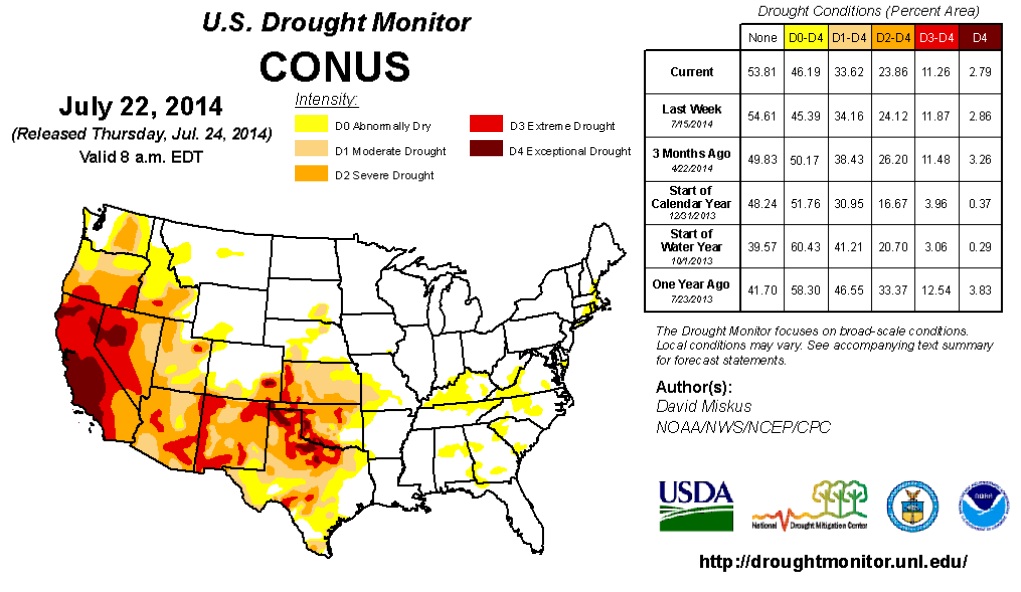
U.S. Drought Monitor
The latest drought map still shows severe drought across the entire state of California! In fact, nearly 37% of the state is in the worst drought classification - EXCEPTIONAL DROUGHT.
"During July 24-28, wet weather is forecast for the eastern third of the Nation, Pacific Northwest, and parts of the northern and south-central Plains. Later in the period, some monsoonal moisture is expected to trek northward into Arizona, New Mexico, and Colorado and trigger scattered light to moderate showers. Little or no precipitation for the 5-day period is expected in California and the Great Basin, north-central Rockies, southern Plains, and central Great Plains. Temperatures should average below normal across the northern tier of States and above normal across the southern third of the U.S., with the greatest positive departures in the Southwest. For the ensuing 5-day period, July 29-August 2, the odds favor above median precipitation from the eastern Great Basin and Arizona southeastward along the Gulf Coast and northeastward along the southern and middle Atlantic Coast. Sub-median precipitation is likely in the Pacific Northwest, and from the northern Plains and upper Midwest southeastward into the Tennessee Valley. Western Alaska is expected to observe below median rainfall, with the opposite forecast in the southeastern Panhandle. An expected strong ridge of high pressure over the Far West and a deep trough over the eastern U.S. will favor strong chances of above-median temperatures in the West and below-median readings in the eastern half of the U.S."
Tropical Update
Active weather continues in the Eastern Pacific with 3 different waves that the National Hurricane Center is keeping an eye on. So far, there have been 7 named storms in the Eastern Pacific so far this season (started May 15); the latest being Genevieve. The loop below shows the sunrise over Genevieve as a Tropical Depression on Saturday.

Thanks for checking in and have a great rest of the weekend! Don't forget to follow me on Twitter @TNelsonWNTV

No comments:
Post a Comment