By Todd Nelson
Not sure about you, but I've been sprinting to get most out of this fleeting Minnesota Summer. If you haven't noticed yet, we've entered the summer slide. Climatologically speaking, our average high peaked in mid July in the mid 80s and by the end of August, it'll be in the upper 70s. We've also lost nearly 1 hour of daylight since the Summer Solstice. On Saturday, Barrow, Alaska saw its first sunrise/sunset since May 11th and will lose nearly 30mins of daylight again today.
Despite our lack of extreme heat (hitting 90° or more only twice this summer - Average is 13 days), the "Dog Days of Summer" officially continue for about another week.
The ancients believed that in addition to our sun, a very bright star called Sirius or the dog star, provided additional heat during the summer months and that's why it got so hot.
Near average temperatures will continue over the next several days with a threat of heavier rain building into far southern Minnesota by midweek. I still don't see significant heat bubbling up from the south anytime soon. Maybe we'll get lucky and enjoy cooler temps for the MN State Fair this year. I can't believe it's only 2.5 weeks away! EEK!
======================
MONDAY NIGHT: Mostly clear, more comfortable sleeping. Low: 60
TUESDAY: Comfortable sunshine. Dew point: 56. High: 79. Winds: ENE 5-10.
TUESDAY NIGHT: Clouds thicken. Low: 62.
WEDNESDAY: Sun fades. Soggy in south/southwestern MN. High: 81
THURSDAY: Front stalls in southern MN. Late day/overnight thunder possible. Wake-up: 61. High: 80
FRIDAY: Unsettled, spotty T-storms. Wake-up: 62. High: 80
SATURDAY: Murky sky. Wetter day of the weekend. Dew point: 62. Wake-up: 64. High: 83
SUNDAY: Threatening PM Sky. Not a washout. DP: 63. Wake-up: 65. High: 84.
MONDAY: Muggy. Stray afternoon downpour. DP: 61. Wake-up: 66. High: 85.
=========================
This Day in Weather History
August 5th
1904: Detroit Lakes woman is hit by lightning. It melted her hairpins and steel in corset but does not kill her.
=========================
Average High/Low for Minneapolis
August 5th
Average High: 82F (Record: 100 in 1947)
Average Low: 63F (Record: 48 in 1994)
==========================
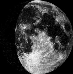
Moon Phase for August 5th at Midnight
2.3 Days Since First Quarter
==========================
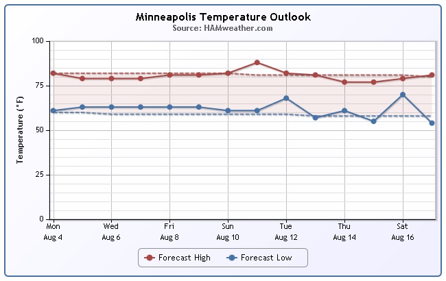
Minneapolis Temp Trend
A look at the Minneapolis temperature trend through mid August suggests near average temperatures through much of the time. Keep in mind that we've only seen 2 days with 90° or warmer this summer. According to NOAA climate data from 1979-2000, Minneapolis averages nearly 13 days with 90° or more.
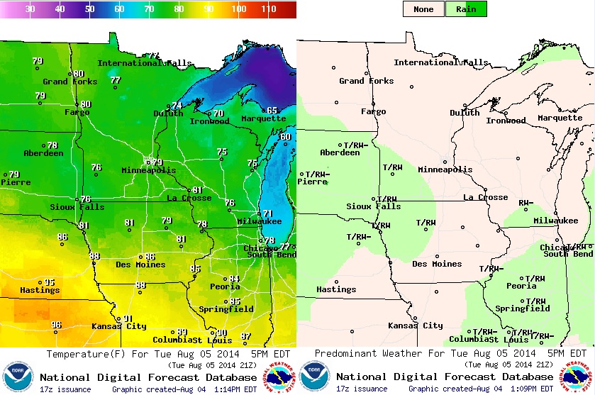
Tuesday Weather Outlook
Not a bad Tuesday ahead with more sun and comfortable temperatures/lower dewpoints. Another wave of energy will start building into southwestern MN late and continue through midweek. Rainfall potential and amounts look much greater across the southern part of the state over the next few days.
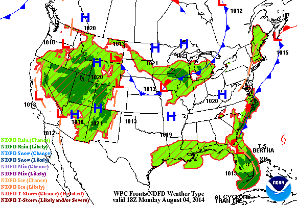
Weather Outlook
Watch the dark green coloring move from the Western U.S.into the Midwest by AM Wednesday. This wave of energy will be responsible for heavy rainfall potential across parts of SD, southern MN and into IA.
Tuesday Rainfall Potential
According to NOAA's HPC, the rainfall potential from AM Tuesday through AM Wednesday looks impressive near Sioux Falls, SD as our next wave drifts in from the High Plains. This is actually from the say system that produced impressive rainfall in the western U.S. over the last few days including the record rainfall in Los Angeles and Las Vegas over the weekend.

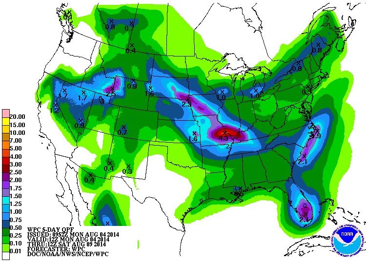
5 Day Precipitation Outlook
As the wave of energy continues through the midsection of the nation, heavy rainfall potential will follow. Note the potential rainfall maximum of near 4" near St. Louis, MO through AM Saturday. Isolated flooding concerns may be possible.
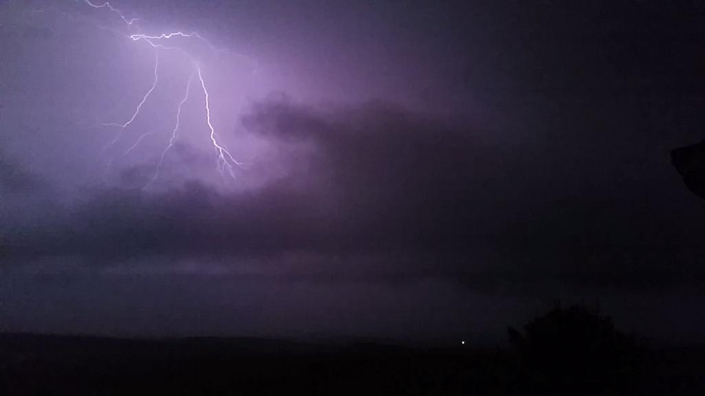
Western Rainfall
Thanks to @BobbyRJAnderson out of Lake Mead, NV for the great picture below. Monsoon thunderstorms associated with an upper level low pressure system. There were several record rain and flash flood reports over the last several days as this wave has slowly drifted north.
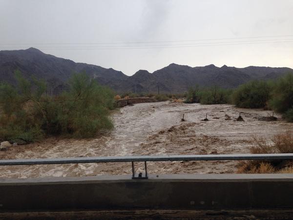
Southwest Flood Concerns
Thanks to @aznerium for the incredible flooding picture below out of Tucson, AZ. It doesn't take much rain to produce scenes like this as most of the moisture is runoff across the dry desert landscape. Flash flooding and mudslides actually claimed the life of 1 person in San Bernadino County, California over the weekend. Tucson, AZ saw less than 1.50" of rain in July, which makes it the 39th driest July on record, but it was also the 13th warmest July on record!
California Mudslides
"MOUNT BALDY, Calif. -- Thunderstorms that swept across Southern California on Sunday led to the death of one person and caused mountain mudslides that stranded more than 2,000 others, authorities said.
A body was found in a car that was swept into a rain-swollen creek in Mount Baldy and overturned, San Bernardino County Fire spokesman Chris Prater said."
Read more on the California Mudslides from CBSNEWS HERE:
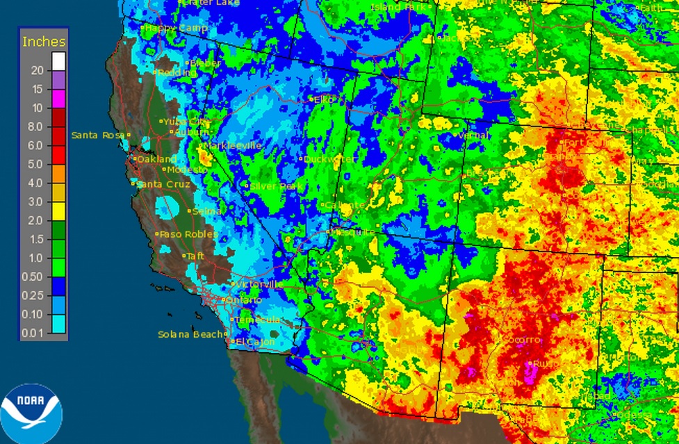
30 Day Rainfall Estimates
Here is the 30 day radar estimate of rainfall over the Southwestern U.S.. Note the deep reds in pockets around the Four Corners region, which indicates nearly 5" of rain or more. Some along the Front Range of the Rockies have seen nearly 6" to 10" since early July.
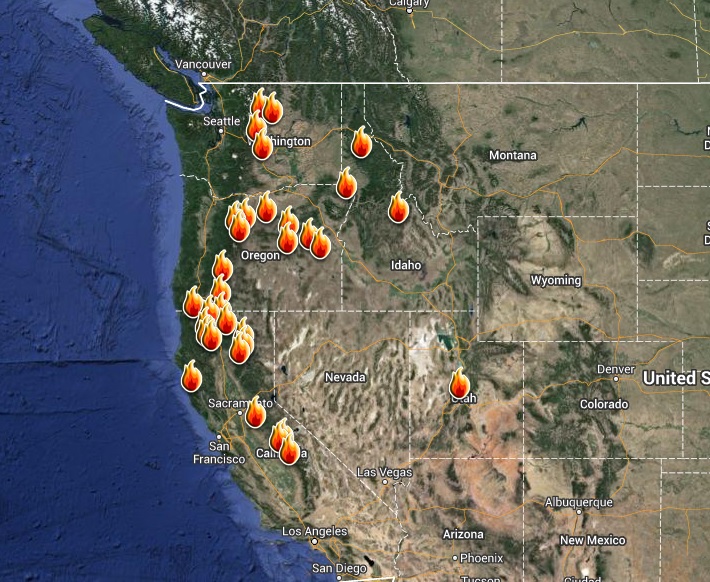
Western Wildfires Continue
Despite the recent rains, wildfires continue to rage in the Western U.S.. Here's a look at all the current large wildfires ongoing.
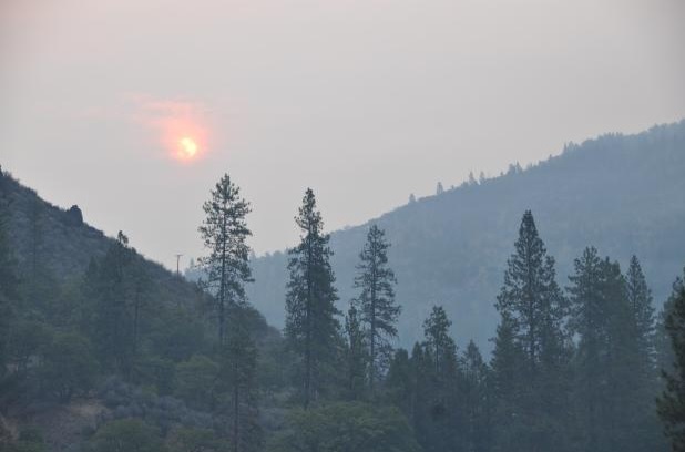
Beaver Fire Continues
One of the bigger fires in California is the Beaver Fire located in the Kalamath National Forest. This fire, which was nearly 10,500 acres as of midday Monday was caused by lightning and has caused a number of folks to be evacuated.
See more from Inciweb.nwcg.gov HERE:
(image courtesy: Inciweb.nwcg.gov)
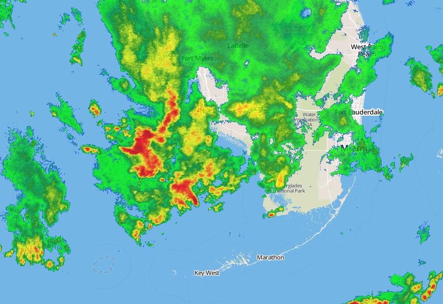
Naples, Florida Rainfall
As of 4pm local time, Naples, Florida had seen 6.45" of rain a new record for the day and a record for the wettest August day in recorded history. The radar image below was from around 7pm EDT as it was still raining in Naples.
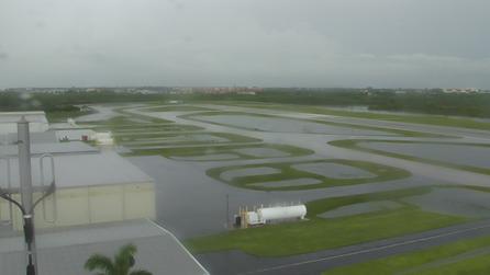
Take a look at the WeatherBug Camera from the Naples, FL Municipal Airport where the runways were flooded. There were reports that flights had to be diverted.
See the latest WeatherBug camera HERE:
Hurricane Bertha
Bertha became our 2nd hurricane of the 2014 Atlantic Hurricane season late Monday morning north of the Bahama Islands. The good news is that Bertha doesn't look to pose any major threats (other than an increase in rip currents along the East Coast) to the U.S. as she drifts northeast into the Canadian Maritimes through the week.
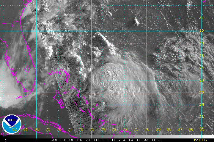
Tracking Bertha
The latest track on Bertha takes it east of the East Coast through the week. One of the biggest threats for coastal communities will be the rip current potential.

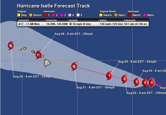
Hurricane Iselle
Look at this beast! Iselle looked amazing midday Monday as a category 4 Hurricane! Unfortunately, Iselle is tracking towards the Hawaiian Islands and could be an impact later this week.

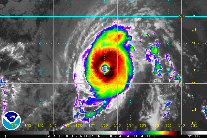
Tracking Iselle
According to the National Hurricane Center, late this week could be a little more interesting with a larger surf and heavy rains across the Islands.
Thanks for checking in and have a great rest of your week! Don't forget to follow me on Twitter @TNelsonWNTV

No comments:
Post a Comment