78 F. high in the Twin Cities Monday.
81 F. average high on August 11.
80 F. high on August 11, 2013.
.04" rain fell at MSP International Airport yesterday.
August 11 in Minnesota Weather History:
2000: Record setting dew points in Minnesota. The Twin Cities had a dew point of 76 with a rare 80-degree dew point at Faribault.
1821: The end of an eight-day heat wave at Ft. Snelling. Temperatures were in the 90's each day.
An Easy August?
"Every
year, August lashes out in volcanic fury, rising with the din of
morning traffic, its great metallic wings smashing against the ground,
heating the air with ever-increasing intensity" wrote Henry Rollins.
If
you've ever been to Florida, Phoenix or sub-Saharan Washington D.C. in
August you know the definition of hot. With the jet stream lifting north
into Canada winds over the USA are often light & stagnant this time
of year, allowing haze, humidity (and pollution) to linger, adding
sweaty insult to triple-digit injury.
But Minnesota has been
relatively lucky: 90s have been rare; a few spasms of severe weather but
no major tornado swarms or crop-damaging hailstorms. We've obviously
dried out after June's statewide monsoon and so far August has brought
more sunny, lukewarm days than July, with a touch of smoke from Canadian
wildfires.
All in all a step in the right direction.
A dry,
sunny sky lingers right into Saturday; just an isolated Thursday
T-shower. Storms become more numerous Sunday as dew points rise to 70F.
Cue the free sauna. Highs may brush 90F early next week.
Football and back-to-school hype is in the air, but don't write off the summer of '14 just yet.
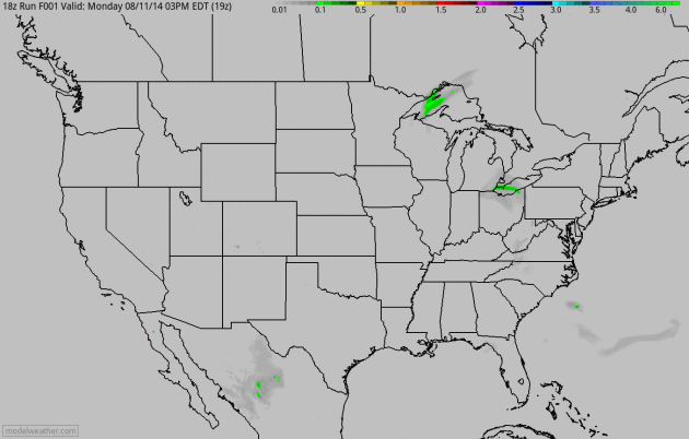
An Active Cold Front.
The same frontal boundary that sparked showers and a few T-storms from
eastern Minnesota into Wisconsin Monday will spread locally heavy rains
across the Great Lakes and Mid Atlantic region into New England by
Wednesday. Some 2-3" rains are possible from the Delaware Valley to New
York City. Heavy rain soaks portions of the Pacific Northwest, while
California stays dry. 60-hour accumulated rainfall (4 KM WRF) model
courtesy of NOAA and HAMweather.
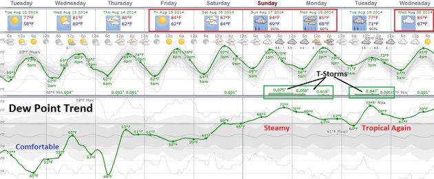
Extended Outlook: July.
Temperatures gradually cool in August, but I'm not seeing any sign of a
significant cool-down, not yet. Today will be comfortably cool, but 80s
return tomorrow into the weekend, maybe upper 80s by Saturday. After
low dew points today humidity levels rise to near 70F by Sunday and much
of next week, back in the oh-zone. The best chance of T-storms: Sunday
into Tuesday of next week as tropical air approaches. Graph:
Weatherspark.
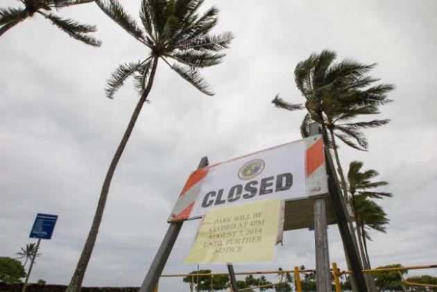
How Tropical Weather Shook Up An Island Paradise.
U.S. News
has a good recap of Iselle's impact on Hawaii last week; here's an
excerpt: "...While the Big Island helped curb Iselle, it also took the
brunt of the storm. About 25,000 people lost electricity. Coffee farmers
navigated flooded streets to check on their crops, and residents used
chain saws to break up fallen trees blocking roads. Days later,
thousands remained in the dark and were told to expect extended outages.
Water, ice and other supplies were flown to the area called Puna, and
roads cleared, Gov. Neil Abercrombie said Sunday..."
Photo credit above: "
Winds
from Tropical Storm Iselle blow palm trees near a sign warning of the
closure of Kualoa Regional Park in Honolulu on Friday, Aug. 8, 2014. All
of the public parks on Oahu were closed. Iselle came ashore onto the
Big Island early Friday as a weakened tropical storm, while Hurricane
Julio, behind it, is forecasted to pass north of the islands. Iselle is
the first tropical storm to hit the state in 22 years." (AP Photo/Eugene Tanner).
Only 2 Meteorology (Hurricane Hunter) Airplanes Remain To Fly Into East Coast Hurricanes. What can possibly go wrong? Here's an excerpt of a story from Reuters and
Scientific American: "
A
pair of aging airplanes that have flown into more than 100 hurricanes
to provide data for U.S. meteorologists are receiving a retrofit this
month that will leave just one available to fly when storms threaten the
East Coast. Work on the two so-called hurricane hunters has been
staggered over multiple years, ensuring one plane is always available to
track a storm's intensity and path, according to the National Oceanic
and Atmospheric Administration (NOAA), which operates the Florida-based
planes. The retrofit comes at the peak of hurricane season, after the
agency last week predicted fewer storms than normal would affect the
Atlantic region for the rest of the year..."
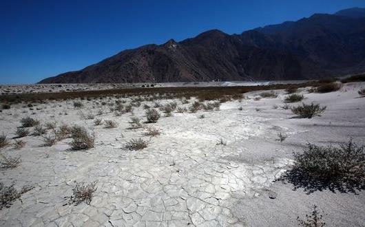
In California, Record Heat Adding To Extreme Drought. Here's a clip from
The Desert Sun: "
The
first half of 2014 was by far the hottest in California in 120 years of
record-keeping, and that heat is exacerbating one of the most
devastating droughts in state history. Month after month, the red and
burgundy patches on the California drought map have been spreading, with
82 percent of the state now classified as being in "extreme" or
"exceptional" drought on the U.S. Drought Monitor website..."
Photo credit above: "
Cracks
spread across the dry bed of parched percolation pond one at the
Whitewater Groundwater Replenishment Facility near Palm Springs on
Wednesday." (Photo: Crystal Chatham/The Desert Sun).
Chart: Your Tech-Peak Is In Your Mid-Teens; And It's All Downhill From There. Well that explains a lot.
Quartz has the uplifting news; here's a clip: "
If
you think you’re a tech guru in the working world, think again. There
is probably someone better than you out there, and it’s not an
executive at a competing firm. Digital savviness peaks sometime between
the ages of 14 and 15, and then drops gradually throughout adulthood,
before falling rapidly in old age, according to a new study of 2,800 Britons..."
Why Names Are So Easy To Forget. Yes, I wish I could remember names with greater predictability.
The Atlantic explains why it's so difficult for most of us - here's a clip: "...
There
are two types of storage in the brain: Long-term and short-term. The
short-term variety is called "working memory," and it functions like a
very leaky thermos. It doesn't hold much and it spills stuff out all the
time. "You can hold just a little bit of information there and if you
don't concentrate on it, it fades away rapidly," Paul Reber, a psychology professor at Northwestern University, told me in an email. "Information like a name needs to be transferred to a different brain system that creates long-term memories that persist over time..."
Against Happiness: Why We Need a Philosophy of Failure.
We all want, need to experience happiness - maybe we have unreal
expectations? Here's an excerpt of a pragmatically-depressing article at
the UK's
Prospect Magazine: "...
But
the spread of depression is partly a side-effect of our addiction to
happiness. Conversely, understanding why we are so miserable should
liberate us from being too miserable about it. We can feel good about
feeling bad. In other words, we need a decent philosophy of failure to
save everyone from thinking what failures they are..."
TODAY: Plenty of sun, breezy. Dew point: 49. Winds: NW 10+ High: 78
TUESDAY NIGHT: Clear - open up the windows. Low: 57
WEDNESDAY: Bright sun, very comfortable. High: 81
THURSDAY: Less sun, isolated T-shower possible. Wake-up: 61. High: 82
FRIDAY: Warm sun, leave work early. Wake-up: 63. High: 85
SATURDAY: Blue sky, almost hot. Dew point: 62. Wake-up: 66. High: 87
SUNDAY: Sticky, few T-storms. Dew point: 68. Wake-up: 68. High: 83
MONDAY: Hot sun, late PM T-storms. Wake-up: 69. High: 89
Climate Stories...
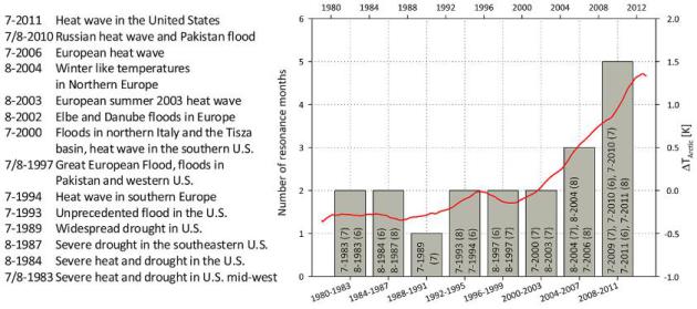
Quasi-Resonant Circulation Regimes and Hemispheric Synchronization of Extreme Weather in Boreal Summer.
It's a long title for a fairly straightforward concept, a symptom of
rapid warming, especially at northern latitudes, which may be impacting
the wavelength of global Rossby waves, creating conditions more
favorable for an elongated (high amplitude) jet stream, one more prone
to extreme weather, severe heat and excessive rains. For several years
I've been wondering if it was my imagination, if we really were seeing
tangible evidence of a more amplified jet stream capable of more
frequent weather extremes over the Northern Hemisphere? Or was there
hard data - research, to back up these observations? Here's a summary of
a technical, but very important new paper from Coumou, Petoukhov,
Rahmstorf, Petri and Schellnhuber at
PNAS.org: "...
The
recent decade has seen an exceptional number of boreal summer weather
extremes, some causing massive damage to society. There is strong
scientific debate about the underlying causes of these events. We show
that high-amplitude, quasi-stationary Rossby waves, associated with
resonance circulation regimes, lead to persistent surface weather
conditions and therefore to midlatitude synchronization of extreme heat
and reainfall events. Since the onset of rapid Arctic amplification
around 2000, a cluster of resonance circulation regimes is observed
involving wave numbers 7 and 8. This has resulted in a statisticially
significant increase in the frequency of high-amplitude quasi-stationary
waves with these wave numbers. Our findings provide important insights
regarding the link between Arctic changes and midlatitude extremes..."
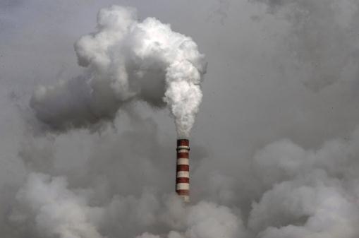
New Study Finds Fringe Global Warming Contrarians Get Disproportionate Media Attention. Equal time? Yes, right after we give time to gravity-deniers and members of the Flat Earth Society. Here's an excerpt from
The Guardian: "...
Specifically,
30% of those few who said that greenhouse gases have caused an
insignificant amount of global warming (or even cooling) reported
frequent media coverage, compared to just 15% of climate scientists who
said greenhouse gases have caused strong global warming. This
disproportionate media coverage of fringe climate contrarians is a
problem known as “false balance,” and has plagued not only politically conservative media outlets, but also purportedly neutral news organizations like the BBC.
It stems from journalists believing it’s “balanced” to give “both
sides” of every issue equal coverage, even if one of those sides
represents the views of a small fringe of qualified experts..." (File photo above: Andy Wong, AP).
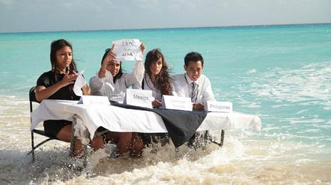
11 Ways Young People Have Revolutionized The Climate Debate.
RTCC.org
has the story - here's the introduction: "Young people are often the
most passionate voices on climate change, and with reason - as the
planet warms over the coming century, it is the future of the youngest
at stake. As such, it is often youth that are the loudest and the most
ambitious in calling for action, proving to be anything from serious
combatants to potential allies to the politicians in charge..."
Photo credit above: "
Young people sit around a wave-submerged negotiating table at the 2010 UN climate talks." (Pic: Bunkerfilms.com / 350.org)
Agricultural Giant Olam International Says Climate Change is "Absolutely a Reality". Australia's
ABC Network has the story and video clip - here's the intro: "
The
head of one of the world's largest agricultural commodity trading
companies is warning Australian primary producers to take climate change
seriously. Olam International chief executive Sunny Verghese has told
Landline that agricultural producers and processors need to take action
now. "It is absolutely a reality that climate change is going to
significantly impact agriculture," he said. "It impacts it both from the
nexus it has with water, and the nexus it has with micro-climate as
well, so it is probably the most important driver to future agricultural
production, productivity and therefore price..."


No comments:
Post a Comment