Hints of August Return
By Todd Nelson
"Inquiring minds want to know."
My 5 year old asked me the other day why leaves change color. At the end of every pause I had, he asked "why" again and again and again. So without trying to be too sciencey, I did the best I could to explain the photoperiod, cold temperatures, carotenoids, anthocyanins and chlorophyll... at one point, during my rambling, I thought I heard him say: "Chlorophyll? More like Borophyll."
Sure, to young kinds, the science behind why leaves change color may not be as interesting as why we can't eat candy for breakfast, lunch and dinner, but they're noticing the changes too!
It's hard not to notice the beauty of nature sometimes. Take a little time to enjoy that one tree in your neighborhood this fall that turns firey red or golden yellow. Before you know it, we'll all be staring at bare trees for the next 6 months... UGH!
A weak impluse of energy will responsible for a few remnants showers today. Most of us will stay dry, but lingering clouds will have temps struggling to get to 70s in most spots. However, hints of August return later this week/weekend with temps nearing 80F and more sun. Might be a good weekend to do a little leaf peeping.
==============
TUESDAY NIGHT: Mostly cloudy with a few showers possible. Low: 58. Winds: SSE5-10
WEDNESDAY: More clouds, few showers. High: 70. Winds: SSE10
WEDNESDAY NIGHT: A few lingering showers early. Low: 58
THURSDAY: Patchy fog, then mild sunshine. High: 77
FRIDAY: Warm sun, clock out early. Wake-up: 59. High: 80
SATURDAY: Blue sky, low humidity, few bugs. Wake-up: 60. High: 81
SUNDAY: Postcard-worthy. Warm sun. Few late day T-Showers possible.Dew point: 58. Wake-up: 60. High: 78
MONDAY: More sun, still quite enjoyable. Dew point: 54. Wake-up: 57. High: 75
TUESDAY: Stray PM T-shower possible. Wake-up: 56. High: 74.
=================
This Day in Weather History
September 24th
1985: 0.4 inches of snow fell in the Minneapolis area.
1982: Tropical air over the state. The Twin Cities has a low of 71.
1869: Heavy rain dumps nearly 10 inches on the White Earth Reservation.
==================
Average High/Low for Minneapolis
September 24th
Average High: 68F (Record 89F set in 1935)
Average Low: 49F (Record 30 set in 1942)
===================
Sunrise/Sunset Times for Minneapolis
September 24th
Sunrise: 7:02am
Sunset: 7:06pm
===================
Moon Phase for September 24th
New Moon at 1:14am (Falling Leaves - Ojibwe)

===================
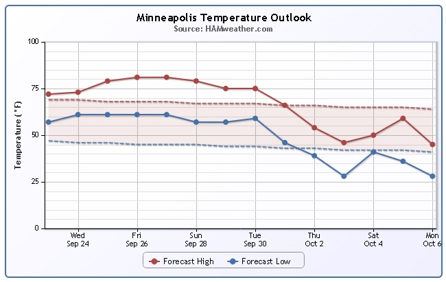
Minneapolis Temperature Trend
Early Fall perfection continues through the last full week/weekend of September with temperatures warming into the 70s/near 80F. ENJOY! Extended model runs are suggesting a bigger drop in the temperature department by early October. Temperatures then could be running well below average, so get outside and remember what 80F weather feels like now before it's too late!
===========================
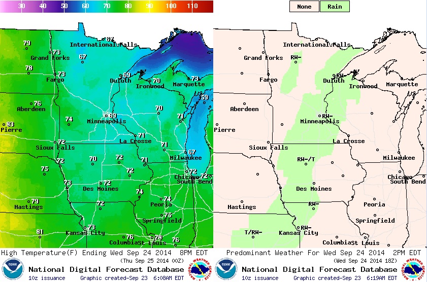
Wednesday Weather Conditions
A weak impulse of energy will push through the Upper Mississippi Valley through midweek. A few spotty showers will be possible through Wednesday, but not much rainfall is expected. Temperatures will be held into the 60s across parts of the state due to additional cloud cover, but where clouds begin to break up, readings make spike into the mid 70s by the afternoon.
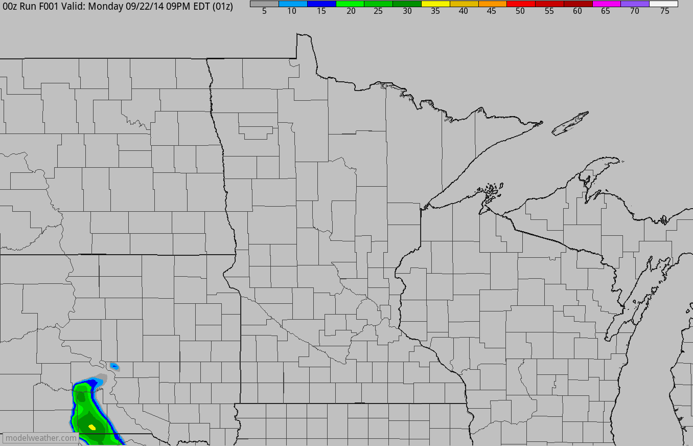
Simulated Radar
The simulated radar through AM Thursday suggests a batch of light/moderate rainfall moving through the region from PM Tuesday into Wednesday. Most of the precipitation will have wrapped up by AM Thursday.
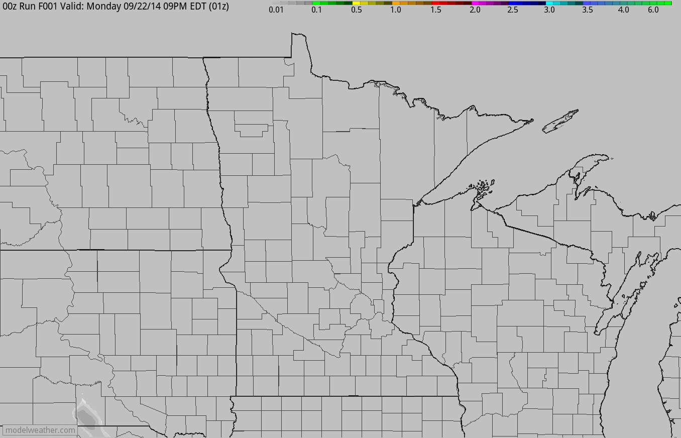
Simulated Rainfall
According to the simulated rainfall accumulation loop below, it doesn't appear that much rain will be falling across the state. Most of the accumulations will be found across the southern part of the state through AM Thursday.
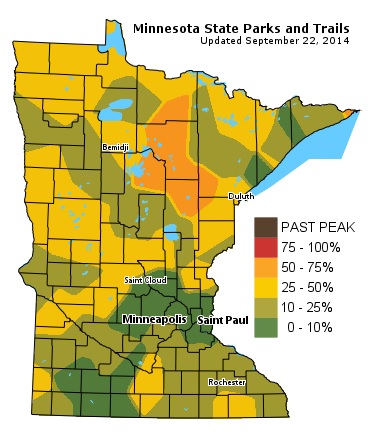
MN Fall Color Update
According to the MN DNR, much of northern Minnesota is 25 - 50% of peak color with a pocket of 50 - 75% of peak color across the north-central part of the state. Looking at the weather conditions for the upcoming weekend, this might be a great weekend to do a little fall color peeping up north!
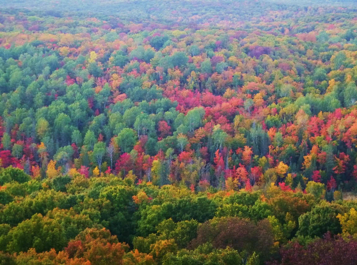
Wisconsin Fall Color Update
Thanks to my good friend Melissa Ganje Kramolis for the picture below who snapped this from the St. Peter's Dome State Natural Area in northern Wisconsin. Fall colors seem to be showing up nicely there too!
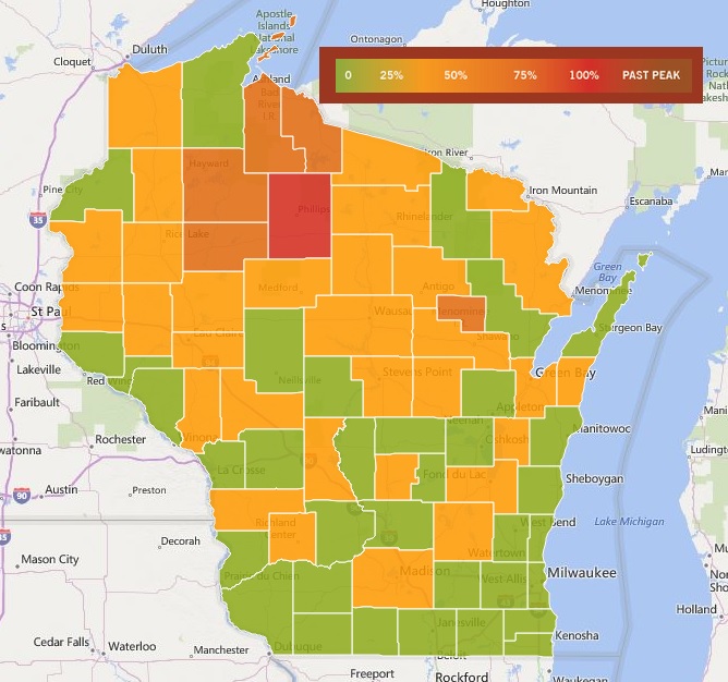
Wisconsin Fall Color Update
According to TravelWisconsin.com - much of Wisconsin is already 50% of peak color with a peak pockets of near peak color already showing up in the north-central part of the state. Yes, this weekend may be a great weekend to do a little leaf peeping in Wisconsin too!
Whistlestop Marathon in Ashland, WI
My running/marathon days have taken a bit of an extended sabbatical over the past few years, but when my wife and I were running on a more regular basis, one of our favorite marathons/half marathons at this time of the year was the WhistleStop Marathon in Ashland, WI. On a beautiful October day, you can't beat the run and the views! If you're a runner and are looking for another run yet this year, check it out! Fall colors tend to peak around the time of the run in early October too, so it makes it even better. This year the race is the weekend of October 10th & 11th
See more information from the WhistleStop Marathon HERE:
(photo courtesty: WhistleStop Marathon)

Medtronic Twin Cities Marathon
Of course, who could forget about the Medtronic Twin Cities Marathon! The marathon this year is only 2.5 weeks away (Sunday, October 5th)!! This is also another beautiful run that takes runners through the some great spots in Minneapolis. Let's hope the weather cooperates this year!
More information about the Medtronic Twin Cities Marathon HERE:
(photo courtesty: Medtronic Twin Cities Marathon)

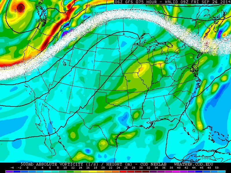
Upper Level Winds
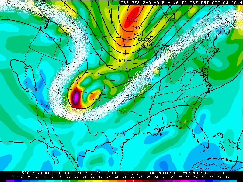
The image below shows the upper level wind pattern (white line) by late this week. Note that the white line is well north of Minnesota, which will allow above average temperatures to settle in for a several day period.
An extended weather forecast into early October suggests a change in the upper level wind pattern. This (potential) trough of low pressure could mean cooler than normal conditions returning to the Upper Midwest by early October... stay tuned.
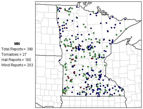
Severe Storm Reports This Year
According to NOAA's SPC, the PRELIMINARY storm reports so far in 2014 include 390 total reports (hail, high wind and tornadoes). So far there have been 27 tornado reports across the state. According to NOAA's NCDC the (1991-2010) annual average number of tornadoes in Minnesota is 45. Interestingly, the (1991-2010) average for October tornadoes in Minnesota is 1. Despite that, the peak of tornado season is over (Peak: June averages 18) and we will likely finish below average tornadoes in Minnesota this year barring any major severe weather outbreaks this Fall.
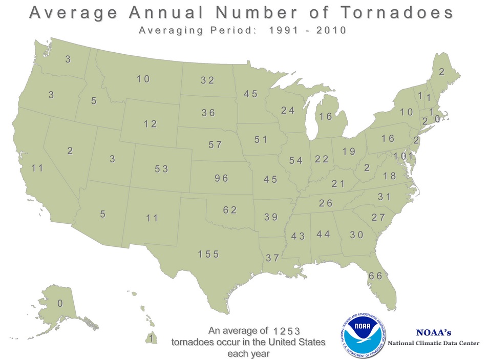
National (1991-2010) Average Annual Tornadoes
According to NOAA's NCDC, the average annual tornadoes across the country is 1,253 with 155 of those in Texas! Interestingly, this has been a fairly quiet year for tornadoes across the country too!
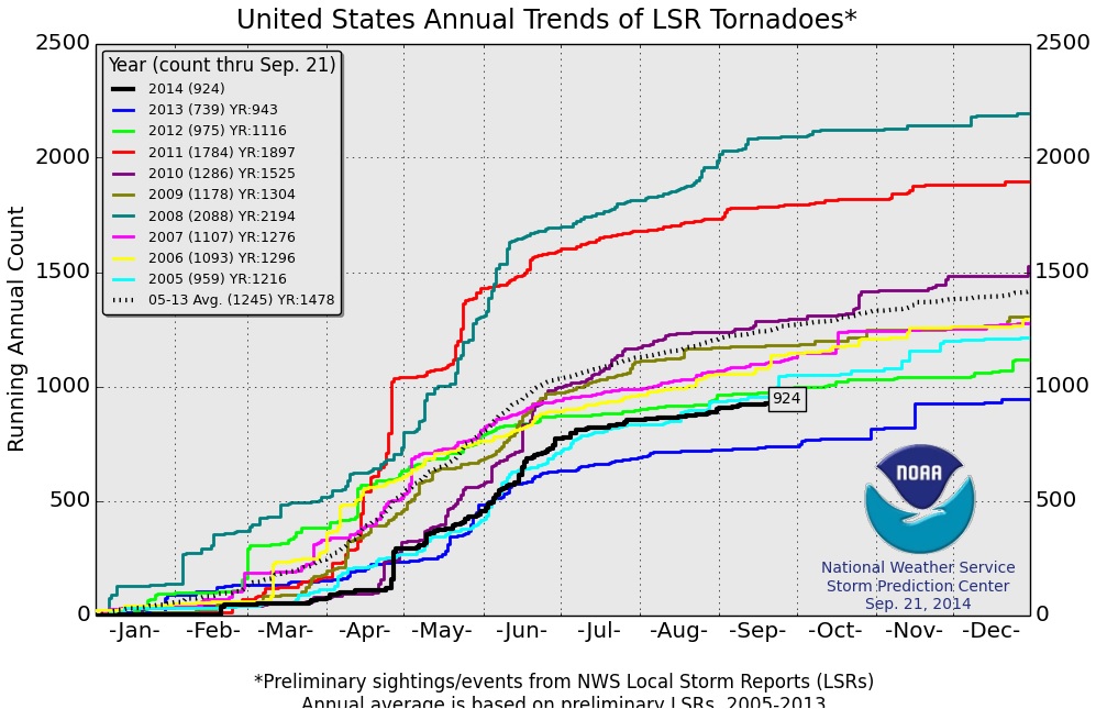
2014 Preliminary Tornadoes vs. Average
Here's an interesting view from NOAA's SPC regarding this year's tornado reports and how it compares to average and years past. This graphic suggests that there has been 924 preliminary tornado reports across the nation through September 21st, which is well below the (2005-2013) average of 1,245 through that date. The only other year that saw as few tornadoes as this year (since 2005) was last years 739 through September 21st.
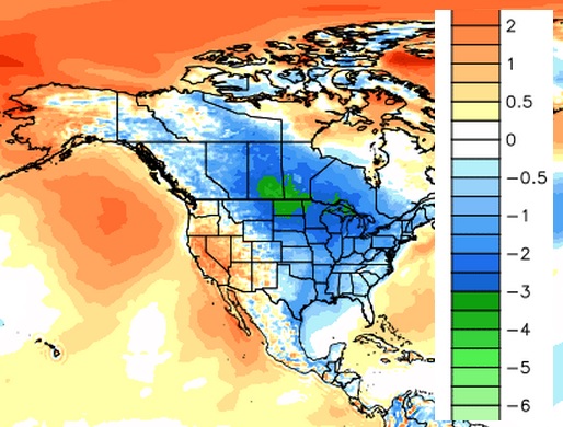
2014 Running Cooler Than Average
Here's an interesting graphic from WeatherBell that suggests a large chunk of North America has been below average temperatures so far this year. This cooler than average weather may be partly responsible for our below average severe weather/tornado reports so far this year...
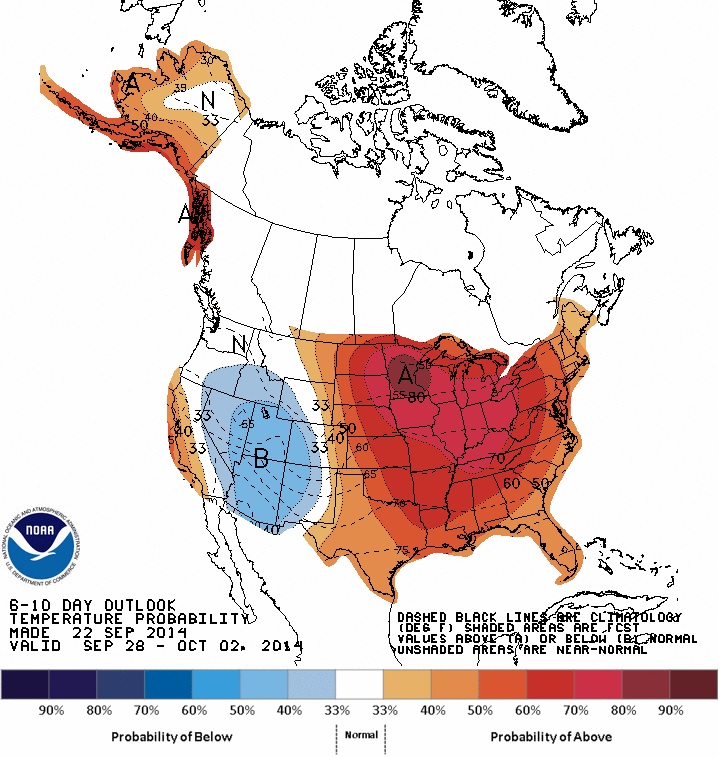
6 to 10 Day Temperature Outlook
According to NOAA's CPC, the 6 to 10 day temperature outlook suggests a good chance of above normal temperatures in the eastern two-thirds of the nation from late Sept. - early Oct., while the western third of the country has a good chance of cooler than normal temps.
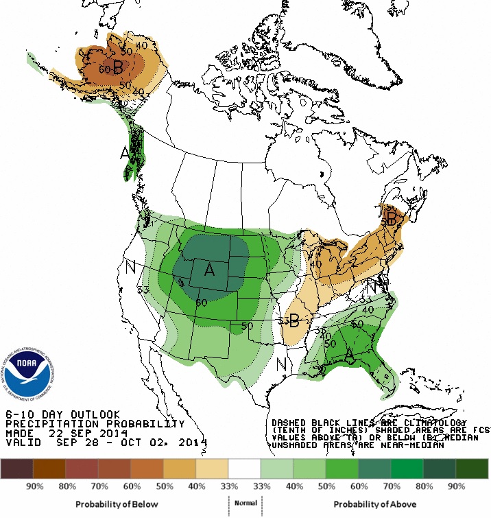
6 to 10 Day Precipitation Outlook
According to NOAA's CPC, there is a good chance that the western U.S. will see above normal precipitation from late Sept. - early October.
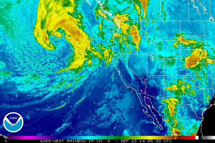
Pacific Storm
A fairly powerful storm system (non-tropical) in the Eastern Pacific Ocean is slowly working east and will bring some much needed precipitation to the West Coast. The 'comma' shape to the counter-clockwise area of rotation suggets that the storm is a mature low pressure system
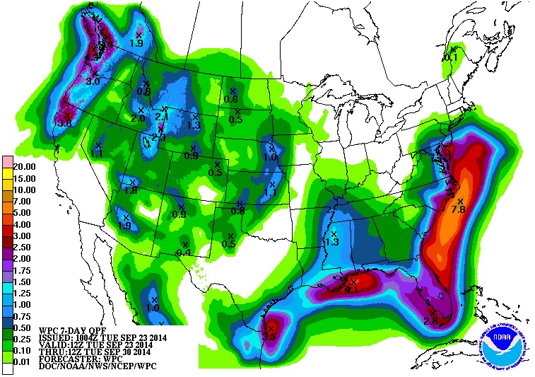
Precipitation Outlook
According to NOAA's HPC, the 7 day precipitation outlook shows abundant moisture possible from the Gulf Coast to Florida to the East Coast, while a decent amount of moisture will begin to roll into the Rockies/West Coast. The only spot in the Western U.S. that isn't expected to see any rainfall is southern California.
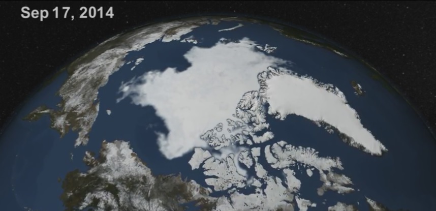
6th Lowest Arctic Sea Ice in Satellite History
"Arctic sea ice has started to reform after reaching what appears to be an annual minimum that was the sixth-lowest on satellite record, the National Snow and Ice Data Center said on Monday.
Sea-ice coverage fell to 5.016 million square kilometers(1.94 million square miles) Wednesday, slightly below the minimum reached last year and well below the average recorded from 1981 to 2010, according to the NSIDC. This year’s ice minimum was well above the record minimum of 3.41 million square kilometers in 2012, according to NSIDC data."
See Ice Animation from NASA.gov HERE:
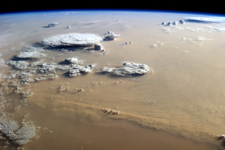
Dust Storm Over Sahara Desert
"More dust blows out of the Sahara Desert and into the atmosphere than from any other desert in the world, and more than half of the dust deposited in the ocean lifts off from these arid North African lands. Saharan dust influences the fertility of Atlantic waters and soils in the Americas. It blocks or reflects sunlight and affects the formation of clouds. By way of the dry Saharan air layer, dust either promotes or suppresses the development of Atlantic hurricanes, an enigma that scientists are trying to sort out.
In early September 2014, it looked like this sandy landscape had changed places with the sky. The photograph above was taken by astronaut Alex Gerst on September 8, 2014, from the International Space Station. The ISS was over Libya at the time, and Gerst was looking south-southwest over a storm that stretched hundreds of kilometers across the sand seas of the Sahara."
Thanks for checking in and have a great rest of your week! Don't forget to follow me on Twitter @TNelsonWX

No comments:
Post a Comment