54 F. high in the Twin Cities Thursday.
61 F. average high on October 9.
76 F. high on October 9, 2013.
October 9 in Minnesota Weather History. Source: Twin Cities National Weather Service:
1977:
A few locations received early snow, including Minneapolis with 2.5
inches, Gaylord with 2 inches, and Jordan with 2 inches of snow.
1970:
Early snowfall was recorded in west central Minnesota. Snow totals
ranged from a trace to 4.2 inches in Benson. Other areas included
Montevideo with 4 inches, Canby with 3.2 inches, Morris with 2.6 inches,
Willmar with 2.5 inches. New London, New Ulm, and Buffalo all recorded 2
inches of snowfall.
1949:
Bizzare storm brings Hurricane force winds across Minnesota. This was
possibly the strongest non-thunderstorm winds seen in Minnesota. Top
winds were clocked at 100 mph at Rochester, with a gust of 89 mph at the
Twin Cities International Airport. 4 deaths and 81 injuries were
reported. Numerous store windows were broken, and large chimneys
toppled. The top 10 floors of the Foshay building were evacuated with
the tenants feeling seasick from the swaying building.
1928: Record high temperatures were set across central Minnesota with high in the upper 80s to lower 90s.
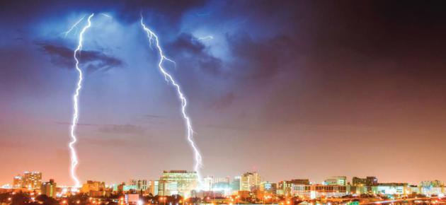
 Perfect Pause
"Bittersweet
October. The mellow, messy, leaf-kicking, perfect pause between the
opposing miseries of summer and winter" wrote Carol Bishop Hipps.
Summer
is on life-support. 60 degrees is the new definition of "warm front".
70s might constitute a heat wave. Considering it snowed 2.5 inches on
this date in 1977 I'm not going to whine about a little morning frost or
a smudge of rain on Sunday.
This is about as benevolent as the
sky ever gets in mid-October, when massive north-south temperature
extremes can fuel violent full-throttle storms.
NOAA now says
there's 66 percent chance of a mild El Nino from winter into spring of
2015, which should (in theory) lower the odds of a bitter blocking
pattern similar to last year. We'll see snow and cold, but less
mid-winter misery, I pray.
Crisp, comfortable sunshine lingers
into Saturday; temperatures pretty closer to average. I expect few
complaints. Showers straggle in late Sunday and the bulk of any rain
Monday stays east of MSP.
A high pressure ridge treats us to a
string of stunning, 60-degree days next week. Winds aloft shift to the
west, turning on a mild, Pacific flow for Minnesota.
Don't rule out a super-sized autumn!
* photo credit: Shad Van Matre.
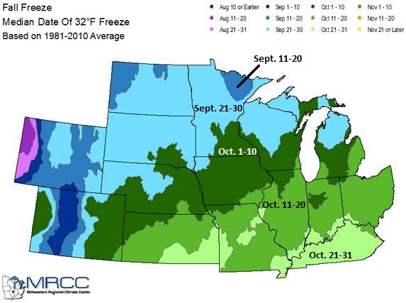
First Freeze.
The map above shows the median date of the first 32F freeze, based on
30 year averages since 1981. The growing season typically ends by
mid-September up north, closer to October 5-10 near Rochester, Winona
and La Crosse. Source: Midwestern Regional Climate Center.
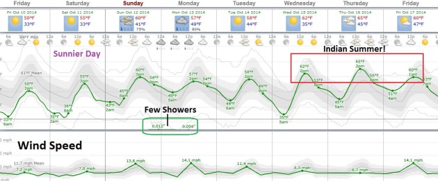
Semantics.
Technically you need to experience the first frost/freeze of the season
before a subsequent mild spell can be called "Indian Summer". And yes,
we want to be technical. Whatever you call it next week should be pretty
amazing with a streak of 60-degree days; I still think 70F is a
possibility by Thursday. Frost this morning gives way to bright sun and
low to mid 50s; Saturday a bit milder with southeast winds - the next
chance of showers Sunday afternoon into Monday morning.
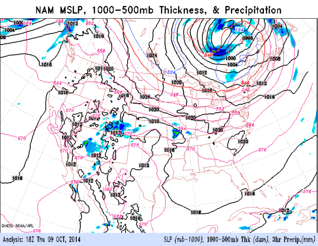
Mid South Soaking.
NOAA's NAM model prints out very heavy rainfall amounts from Missouri
into Kentucky, along the leading edge of chilly, Canadian air. A frosty
bubble of high pressure drifts east, into the Great Lakes, south winds
on the backside of this fair-weather-maker warming up the Plains a bit
before showers arrive late Sunday into Monday. Source: NOAA ARL.
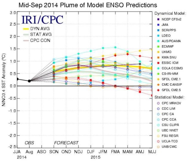
66% Probability of Mild El Nino.
NOAA CPC is now predicting a mild El Nino warming phase of the Pacific
setting in by November or December and lasting into spring of 2015.
Statistically, this would tend to favor a somewhat milder winter for
much of the Lower 48 states than what we endured last year. Here's an
excerpt from
NOAA: "...
The
consensus of forecasters indicates a 2-in-3 chance of El Nino during
the November 2014 - January 2015 season. This El Nino will likely remain
weak (3-month values of the Nino-3.4 index between .5C and .9C).
throughout its duration. In summary, El Nino is favored to begin in the
next 1-2 mmonths and last into the Northern Hemisphere spring 2015..."
Scared of Storms? Ball State Studies Severe Weather Phobias.
It's good to be a little paranoid about the weather, especially during
severe storm, flash flood and icing situations, but a pervasive,
paralyzing fear of the weather? Here's the introduction to a story at
Indystar: "
Do
you lose sleep over the weather? One in 10 Americans may suffer from
severe weather phobia — a fear of extreme weather such as hurricanes,
wildfires or tornadoes so strong that they may feel helpless or can’t
sleep, according to new research. Ball State University geographer Jill
Coleman teamed up with her mother, University of Kansas psychologist
Karen Multon, to survey 300 people about their weather anxieties..."
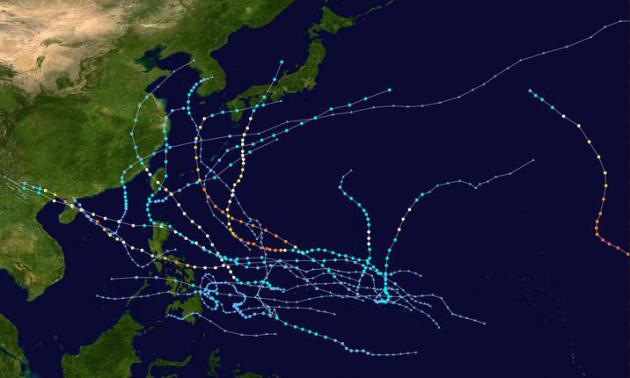
Six Super-Typhoons In The Western Pacific So Far in 2014. 19 named storms, 9 typhoons, and 6 of those have reached super-typhoon status, according to an update at
Decoded Science; here's an excerpt: "
The
western Pacific Ocean has had an active typhoon season: 19 storms have
been named, nine becoming typhoons, and six Super-Typhoons with winds
over 150 miles per hour. The latest, Vongfong, became the strongest with
winds of 180 miles per hour on Tuesday, and is on the same path as last
week’s Typhoon Phanfone which raked the Japanese coast and passed
directly over Tokyo..."
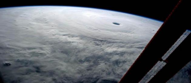
Seen From Space: Super Typhoon VongFong Churns Towards Japan. This Category 5 super-storm should weaken to tropical storm status by the time it reaches Japan. Here's an excerpt from
NBC News: "
NASA astronaut Reid Wiseman tweeted an image of Super Typhoon Vongfong in the western Pacific Ocean
from the International Space Station on Thursday commenting, "I've seen
many from here, but none like this." The most powerful storm of 2014
continues to swirl towards Japan with maximum winds of 165 mph and is
expected to make landfall Monday night..."
Dueling Super Typhoons.
Check out the nearly perfectly-concentric eyewalls for the Category 5
Typhoons in the western Pacific over the last year. Haiyan may have been
the most extreme typhoon (same thing as a hurricane) ever observed
before it came ashore near Tacloban City, Philippines. Vongfong, with a
central pressure of 900 mb, showed characteristics and intensity similar
to that of Haiyan. Graphic: NOAA.
What Sort of Weather Can You Buy for $100 Million Pounds?
A rhetorical question for residents of the UK, where the Met Center is
about to spend a very significant amount of money on a supercomputer
outbreak. Will locals notice the difference in accuracy? Here's a clip
from
The Telegraph: "..
.To
grasp how it might improve matters, we need to understand the basic
mechanics of how the weather is forecast. The Met Office currently takes
in 106 million observations a day from around the world using a variety
of sources, from old-fashioned weather balloons reading the atmosphere,
to satellites high up above the stratosphere, and hundreds of
commercial aeroplanes which send back data as they fly between
destinations..."
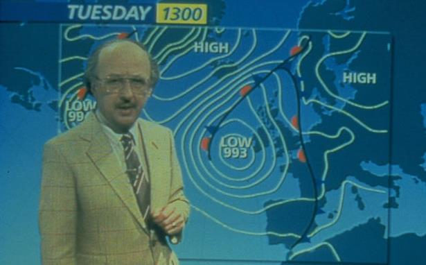
Image credit above: "
Michael Fish’s notorious 1987 storm forecast: the weather and public failure combined are guaranteed to attract an audience." Photo: BBC.
Atlantic: Fewest Named Storms Since 1983. CTV News has more details: "This
year's Atlantic hurricane season is shaping up to be one of the weakest
in decades with only five named storms formed in the region so far this
year. That's the fewest named storms formed during a single season in
the Atlantic since 1983, when there were four..."
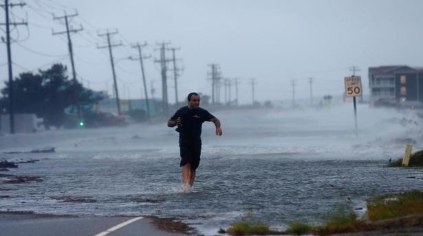
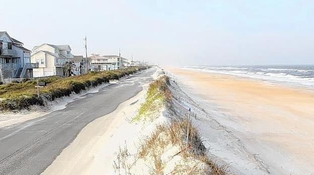
Photo credit above: "A
man crosses a flooded Highway 64 as wind pushes water over the road as
Hurricane Arthur passes through Nags Head, N.C., July 4, 2014." (AP / Gerry Broome, File)
Ebola Fears Are Triggering Mass Hypochondria.
No kidding. That's why I'm watching a lot of HGTV and ESPN these days.
This is bad news for anyone who is already freaked out about their
health, as this snippet at New York Magazine confirms: "...In
a way, what we’re seeing here is hypochondria manifested on a mass
scale, said Catherine F. Belling, an associate professor at Northwestern
University's Feinberg School of Medicine, who has written a book on hypochondria.
“I know that there are a lot of people, clearly, who are very anxious
and panicking at this point, who maybe don’t altogether trust what the
CDC is saying,” she said. “And they’re worried that it’s out in America
now, instead of being far away in Africa...”
Photo credit:
PLoS.
The Worst Charities in America? The Center for Investigative Reporting has the sordid list here.
Sharper Image from 4K TV's Is A Gimmick Worth Having.
Are you ready to spring for a 4K set? Will this be a repeat of 3-D TV,
which belly-flopped in the consumer market? Here's a video and story
excerpt at
The New York Times: "...
The
adoption of 4K TVs will also depend on the programming available in the
higher definition — a sort of chicken-and-egg situation. Without
extensive 4K programming available, people have less incentive to buy
the sets. And if few people buy them, there is less incentive to make
videos in 4K. So far, no channels are broadcasting in 4K, and very few
DVDs come in 4K quality..."
Photo credit above: "Retailers
are soon going to be making a big push for 4K televisions, but the
content is still lacking. Molly Wood visits one company that hopes to
become the Netflix of 4K by being there first. Video by Molly Wood and Vanessa Perez on Publish Date October 8, 2014." Photo by Gero Breloer/Associated Press.
The Case Against Flying Cars. Elon Musk, of Tesla and SpaceX fame, makes a few good points, in my humble opinion. Here's a clip from
The Verge: "
Thanks to his companies Tesla and SpaceX,
Elon Musk is heavily invested in automobiles and rockets. But don't
expect him to combine the concepts any time soon. "I'm not sure about
the flying cars," Musk said during an apperance today at the Vanity Fair
New Establishment Summit. "If the sky was full of cars flying all over
the place, it would affect how things look. It would affect the skyline.
And it would be noisier and there would be a greater probability of
something falling on your head. Those are not good things..."
TODAY: Early frost, bright sunshine. Winds: NW 5-10. High: 54
FRIDAY NIGHT: Clear and chilly - patchy frost late. Low: 32
SATURDAY: Frost, then blue sky, pleasant. Winds: SW 10-15. High: near 60
SUNDAY: Showers after Vikes game. Wake-up: 43. High: 59
MONDAY: Chance of rain, heaviest over Wisconsin. Wake-up: 46. High: 56
TUESDAY: Sunshine returns, pleasant. Wake-up: 39. High: 61
WEDNESDAY: Sunny and lukewarm. Wake-up: 44. High: 66
THURSDAY: September flashback. Mild sun. Wake-up: 45. High: 68
Climate Stories...
California Leads on Climate Change, Says 50-State Tool. USA TODAY has the article; here's the introduction: "
California
has completed the highest number of goals to prepare for climate
change, followed by Massachusetts and New York, according to a
first-of-its-kind 50-state tracking tool unveiled Thursday. In the last
five years, there's been a burst of state efforts to deal with already
occurring climate impacts such as more frequent storms and rising sea
levels. They've ranged from elevating wastewater treatment plants to
insulating roads, building micro-grids for backup power or buying out
homes in flood-prone areas..." (Image:
European Space Agency).
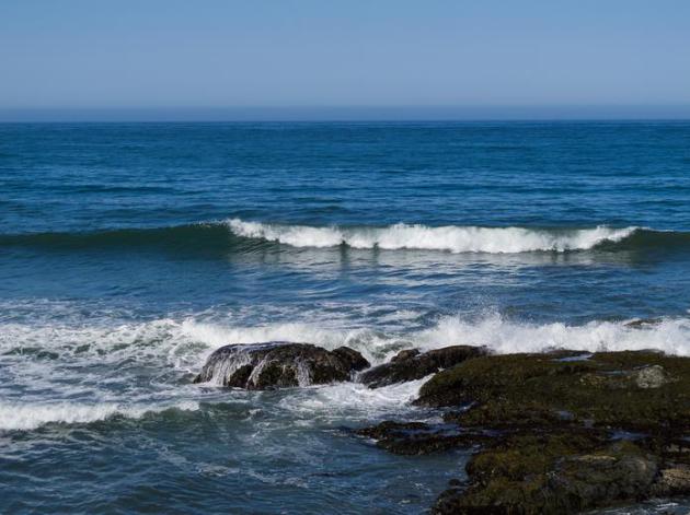
Climate Change Has Raised Ocean Acidity by A Quarter. Discovery News has the story - here's an excerpt: "
Ocean
acidification has risen by a quarter since pre-industrial times as a
result of rising carbon emissions, casting a shadow over the seas as a
future source of food, scientists warned on Wednesday. In the past two
centuries, the sea's acidity level has risen 26 percent, mirroring the
proportion of carbon dioxide it absorbs from the air, they said in a
report to the UN Convention on Biological Diversity (CBD) meeting in
South Korea..." (File image: NOAA).
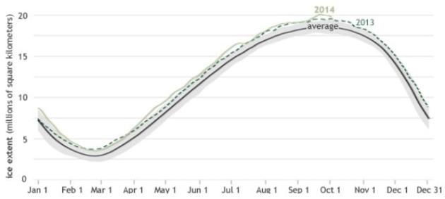
NOAA: Record Antarctic Sea Ice Growth Linked To Its Staggering Loss of Land Ice. Here's a clip from
ThinkProgress: "...
NOAA said in a news release
Tuesday that “as counterintuitive as expanding winter Antarctic sea ice
may appear on a warming planet, it may actually be a manifestation of
recent warming.” The most important thing to know about Antarctica and
ice is that a large part of the South Pole’s great sheet of land ice is close to or at a point of no return for irreversible collapse. The rate of loss of that ice has reached record levels,
tripling in the last five years alone. Only immediate action to sharply
reverse carbon pollution could stop or significantly slow that..."
Graphic credit above: "
Antarctica’s seasonal sea ice extent reached a new high in September even though the Southern Ocean continues to warm." Credit: NOAA.
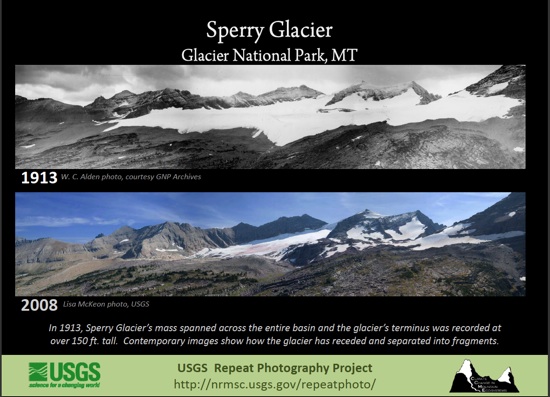
When The Ice Melts. Malcom Brooks has a powerful Op-Ed at
The New York Times; here's the intro: "
Glacier
National Park is melting, its sheets of ice predicted to vanish from
the face of the earth by 2030. I’d known this for decades, and I did
exactly nothing. I’ve lived two hours south of the park for nearly 20
years. I’ve visited and camped there a number of times, and driven the
fabled Going-to-the-Sun Road through some of the more spectacular
mountain scenery on the planet. But I hadn’t in all that time managed
the definitive Glacier experience, the one big item that loomed on my
Montana bucket list: climb to and touch a remnant glacier, before such a
thing is no longer possible..." (Image: USGS).
Why Americans Are Flocking To Their Sinking Shores. As
I tell my friends thinking of retiring to Florida for a Gulf or Bay
view, buy (or rent!) something a few blocks inland, and be patient. You
may get your waterfront property sooner than you think. Here's an
excerpt from
The Chicago Tribune: "...
The
ease with which Huckabee and his neighbors have been able to work
around some of the most restrictive beach development laws in the
country is indicative of a problem that only worsens as rising seas gnaw
at U.S. shores: Americans are flocking to the water's edge, as they
have for decades, even as the risks to life and property mount. And
government is providing powerful inducements for them to do so. Between
1990 – when warnings were already being sounded on rising sea levels –
and 2010, the United States added about 2.2 million new housing units to
Census areas, known as block groups, with boundaries near the shore, a
Reuters analysis found...
East Coast Cities Face Frequent Flooding Due To Climate Change. The sea is rising, and that has implications, especially at high tide. Here's an excerpt from
The Guardian: "...
The
report, Encroaching Tides: How Sea Level Rise and Tidal Flooding
Threaten U.S. East and Gulf Coast Communities over the Next 30 Years,
from the Union of Concerned Scientists
(UCS), found most of the towns on America’s east coast will see triple
the number of flooding events by 2030. By 2045, those towns will see 10
times as many tidal floods – and those floods will seep further inland,
and last longer, the researchers said. Many coastal towns already see
dozens of small tidal floods every year, typically lasting only a few
hours. But the frequency of such events is marching upwards because of
sea level rise – which at some points along the east coast is more than
twice the global average..." (Photo: Aaron Favila, AP).


No comments:
Post a Comment