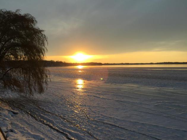
36 F. high in the Twin Cities Saturday.
37 F. average high on November 22.
33 F. high on November 22, 2013.
3" snow on the ground at KMSP.
November 22, 2003: New London and Little Falls both recorded 9 inches of new snow.
November 22, 1983:
Heavy snowfall accumulated over most of central Minnesota with snowfall
totals from 4 inches to almost 1 foot. Minneapolis received 11.4 inches
of snow, while Farmington had 11 inches.
November 22, 1954: 1954 Gale over Minnesota. Considerable damage in downtown Wadena.
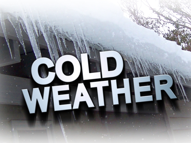
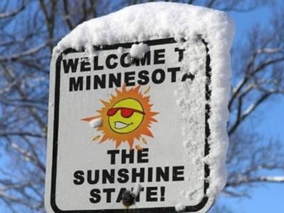
No Sweat
Positive
spin: no bugs, humidity, severe storms or road construction. No raking,
weeding or picking milfoil out of your teeth. What's not to like about
late November? OK, it's been a little chilly;
I'm just grateful
there aren't any large lakes lurking upwind. Could a Buffalo-like 8 FEET
of snow fall on Duluth? Possibly, but Lake Superior is consistently
colder than Lake Erie. You don't have the 40-50 degree temperature
differential that sparked a 48-hour firehose of thunder, lightning and
snow, falling at the rate of 3-7 inches/hour at times.
By the way,
the forecast for Buffalo at the beginning of last week was 1-2 feet of
lake effect snow. No one in their right mind predicts 6-8 feet of snow
from a single event.
Soak up 40s early today; a welcome respite
from nearly continuous Canadian exhaust since November 10. Significant
rain tracks east of town today; a coating of slush possible Monday as
cold northwest winds kick in on the backside of this storm.
Another
couple of inches of snow may fall Wednesday ahead of the next clipper;
"highs" holding in the teens Thanksgiving. Another thaw is brewing a
week from today; longer-range guidance hinting at a few Pacific warm
fronts the first half of December.
A very white Christmas? Bet on it.
Most Consecutive November Days Below 32F Since 1996. Officially we came in at 11 days in a row < 32F, second only to 1880. Details from the
Minnesota DNR: "
Twin
Cities began a streak of "at or below 32 degrees" for a maximum
temperature on Monday, November 10 with a high temperature of 31
degrees. The mercury reached 34 degrees just before midnight on November
21, ending the streak at 11 days. The longest stretch of 32 degrees or
colder is a cold spell that began on November 16, 1880 and lasted for
the rest of November for a streak of 15 days. 11 days has also been
reached in 1911, 1985 and 1996."
Consecutive days of "at or below 32 degrees"
in the Twin Cities (1871-2014)

Streak Began    Streak Ended  Total in Nov.
-------------------------------------------
1880-11-16  to 1880-12-03 15 Days
1911-11-11  to 1911-11-21 11 Days
1985-11-20  to 1985-12-21 11 Days
1996-11-18  to 1996-11-28 11 Days
2014-11-10  to  2014-11-20      11 Days
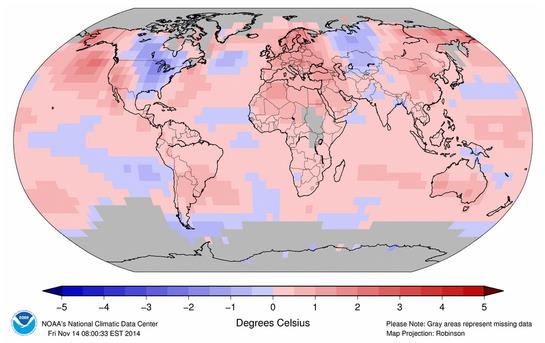
An Exception To Every Rule.
2014 may very well wind up being the warmest year on record, worldwide -
even warmer than 2010 and 1998. What makes this especially noteworthy: a
lack of El Nino, Pacific warming which often turbocharges atmospheric
warming. 2014 will offically be an ENSO-neutral year. NOAA NCDC data
above shows global temperature anomalies from January 1 through the end
of October; trending warmer for much of the planet. The coolest spot in
the Northern Hemisphere? The eastern half of the USA. The perception is
that 2014 was a chilly year. True for much of America east of the
Mississippi but for the planet? Not so much.
Most Traveled Week of the Year.
What can possibly go wrong? Not much close to home, although
Wednesday's clipper may drop a couple inches of slushy snow. Travel
shouldn't be an issue Tuesday; again Thursday, Friday and Saturday. The
coldest day in sight is Thanksgiving, with highs in the teens and a
subzero windchill. Temperatures recover over the weekend; another thaw
possible one week from today.
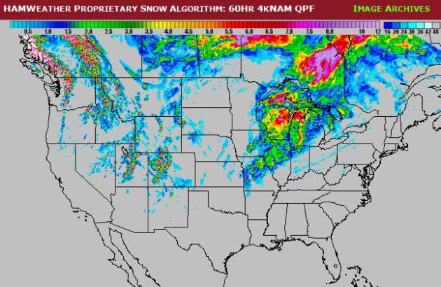
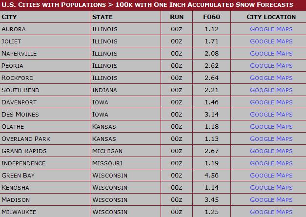
Rainy Start - Slushy Finish.
A surge of rain pushing into Wisconsin and the Great Lakes ends as wet
snow late tonight, with a potential for a few inches of slush from Des
Moines and the Quad Cities to Madison and Green Bay. Map and snowfall
potential: HAMweather.
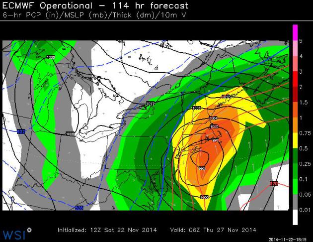
Wednesday - Thursday Nor'Easter.
If your travels take you to Philadelphia, New York, Hartford or Boston
keep an eye on weather late Wednesday into early Thanksgiving Day. The
ECMWF is consistently printing out a formidable coastal storm capable of
inland snow and heavy coastal rains, especially Wednesday night. I
could see some Wednesday PM travel delays due to rapidly deteriorating
weather from PHL and JFK/LGA to BOS.. Map valid 1 am Thursday courtesy
of WSI Corporation.
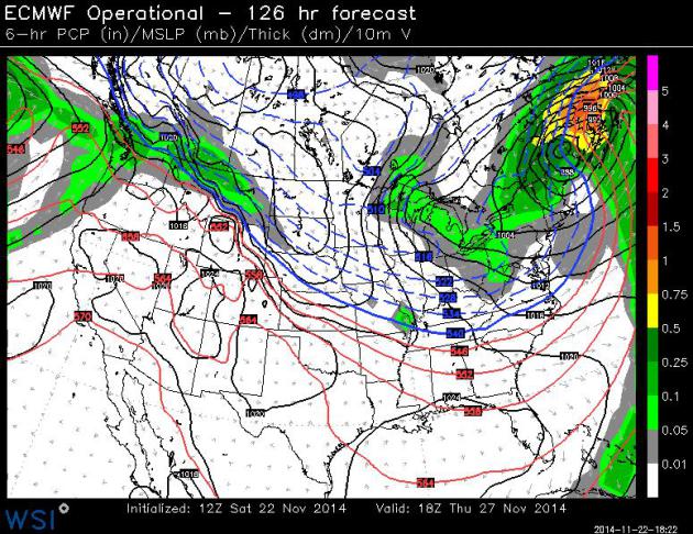
Thanksgiving Day Weather Map.
Here is the European model, valid midday Thursday, showing New England
slowly drying out, lake effect snows returning to the Great Lakes
(including Buffalo) and more cold air drilling into the Upper Midwest.
Dry weather prevails over the southern and western states, more rain
pushing into Seattle with moderate snow over Montana. Map: WSI.
Coldest Minnesota November Since 1996. Surprised? Me neither. Here's a link to
Mark Seeley's WeatherTalk: "...
Following
the winter storm of November 10th, cold air has dominated the state.
Through November 20th average monthly temperatures are running from 6 to
9 degrees F colder than normal, marking the coldest November since
1996. A streak of 12 consecutive days with no temperature reading of 32
degrees F or higher at MSP is the 2nd longest for the month of
November, topped only by 15 consecutive days back in 1880. Pete Boulay
of the Minnesota State Climatology Office has a nice feature on this..."
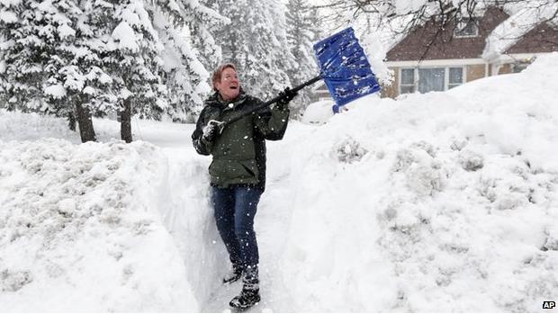
Why Do So Many People Die Shoveling Snow?
Because they're out of shape, have an undiagnosed coronary condition,
and because shoveling is even more strenuous and taxing than running on a
treadmill. Here's an excerpt of a post at
BBC that caught my eye: "...
His
team found that when healthy young men shoveled snow, their heart rate
and blood pressure increased more than when they exercised on a
treadmill. "Combine this with cold air, which causes arteries to
constrict and decrease blood supply, you have a perfect storm for a
heart attack," he says. Snow shoveling is particularly strenuous because
it uses arm work, which is more taxing than leg work. Straining to move
wet and heavy snow is particularly likely to cause a surge in heart
rate and blood pressure, Franklin says..." (Photo credit: Associated Press).
Snow Shoveling 101: How Not To Kill Yourself. Yahoo Health has some
good advice.
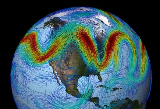
Snowed Under and Frozen Over: U.S. Weather Is Off The Rails, But Why?
The jet stream is "drunk" once again - memories of last winter have
emerged much sooner than anyone wanted or expected. Will it continue,
and how is a rapidly warming Arctic impacting prevailing steering winds?
Here's an excerpt of an explanation at
Capital Weather Gang: "...
Last
summer we saw the 6th lowest sea-ice minimum extent, and the extremely
warm temperatures now over the Arctic are from all the extra heat
absorbed by the Arctic Ocean where ice was lost,” Francis said. “When
the Arctic is so warm, the west winds of the jet stream weaken, and this
favors the highly wavy pattern to the jet stream responsible for this
early winter chill in the eastern U.S as well as the continued drought
and heat in California....”
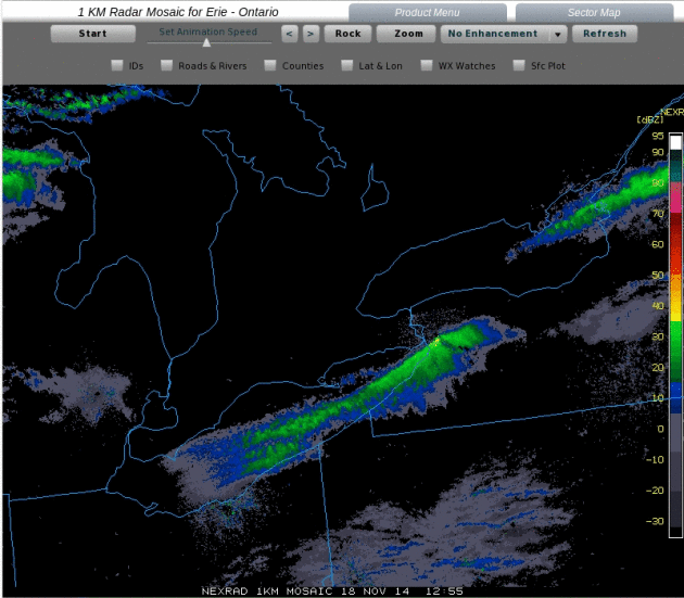
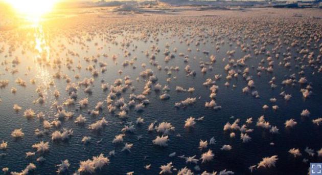
Winter Equivalent of Training Thunderstorm Echoes.
The great irony is that there was enough instability with the severe
snow event in Buffalo for thunder and lightning. It was ultimately a
combination of factors: water temperatures in the eastern end of Lake
Erie in the low to mid 50s, unseasonably cold air at the surface, and
even colder temperatures aloft resulting in extreme instability. Mean
wind vectors kept the most explosive snow band virtually stationary for
the better part of 48 hours, resulting in some 70-90" amounts. Tuesday
radar loop above courtesy of the
University of Wisconsin CIMSS.
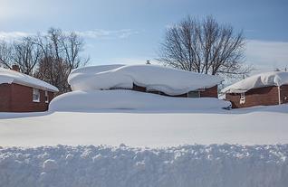
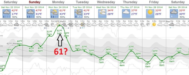
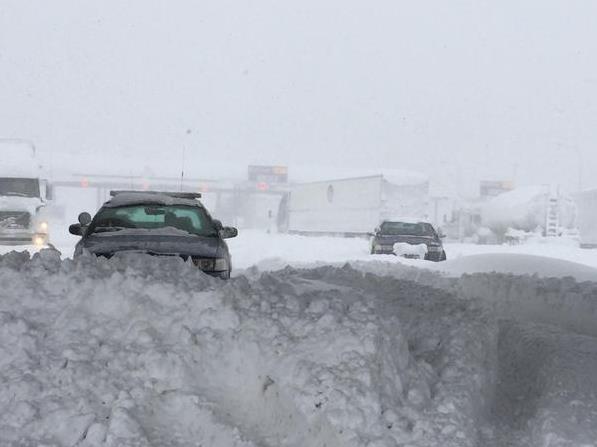
More Evidence of Weather & Climate Volatility: Heavy Rain and 60F for Buffalo by Monday?
ECMWF data suggests a high near 60F Monday afternoon, in spite of small
mountains of snow, especially on the south side of Buffalo.
The Los Angeles Times
has a story recapping the flash flood risk that could materialize early
next week. I'm especially worried about rain falling on snow-covered
rooftops, adding additional weight with more cave-ins likely. Graphic:
Weatherspark.
Flash Flood Watch for western New York, including metro Buffalo.
The concern is heavy rain and 50s by Monday, adding additional weight
to the snowpack on area rooftops, resulting in more collapses into next
week. Details from
The Buffalo News.
Tracking Buffalo's Snow Blitz With Drones? TVSpy has the story and video. Here's an excerpt: "
Buffalo
stations were able to give viewers the softer side of the aftermath of
Lake Effect snow with video shot by Jim Grimaldi’s drone. The local
drone pilot didn’t go far enough or high enough to trigger any action
from the FAA, but he did give WIVB and WGRZ some nice bump video showing how a snowstorm can change a neighborhood. WKBW featured the video on its website. Check it out..."
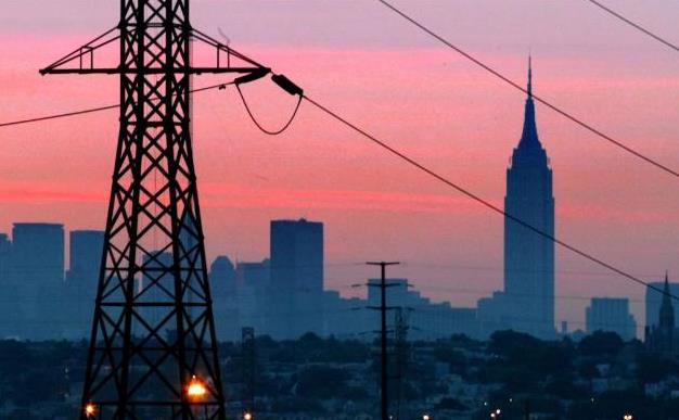
The U.S. Government Thinks China Could Take Down The U.S. Power Grid. Let's change the subject and turn over the sports scores. Quickly, while the power is still on.
CNN has the story and video; here's a clip: "...
China
and "probably one or two other" countries have the capacity to shut
down the nation's power grid and other critical infrastructure through a
cyber attack, the head of the National Security Agency told a
Congressional panel Thursday. Admiral Michael Rogers, who also serves
the dual role as head of U.S. Cyber Command, said the United States has
detected malware from China and elsewhere on U.S. computers systems that
affect the daily lives of every American..." (File photo: AP).

The Real Roots of Midlife Crisis.
I challenge anyone in their 40s or 50s to (honestly) admit that they
haven't had a similar experience. The U-Curve is real, it turns out, and
no, you're not alone.
The Atlantic has a very worthy read - here's a snippet: "...
Long
ago, when I was 30 and he was 66, the late Donald Richie, the greatest
writer I have known, told me: “Midlife crisis begins sometime in your
40s, when you look at your life and think, Is this all? And it ends
about 10 years later, when you look at your life again and think,
Actually, this is pretty good.” In my 50s, thinking back, his words
strike me as exactly right..." (Photo credit: Chris Buck).
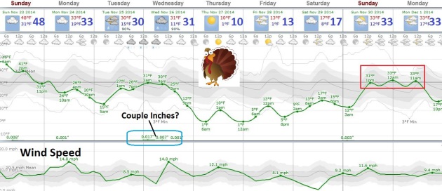
TODAY: Thick fog. A little rain and drizzle. Winds: West 10. High: 43, then falling
SUNDAY NIGHT: Mostly cloudy - wet roads become icy. Low: 24
MONDAY: Colder wind with falling temperatures, coating to 1" of snow. High: 28
TUESDAY: Partly sunny, good travel day. Wake-up: 16. High: 25
WEDNESDAY: Couple inches of snow possible. Wake-up: 20. High: near 30
THANKSGIVING: Intervals of sun, feels like -10. Wake-up: 10. High: 16
BLACK FRIDAY: Good shopping weather. Cold sun. Wake-up: 4. High: 15
SATURDAY: Patchy clouds, light winds. Wake-up: 6. High: 20
Climate Stories...
New Study: Major Investors Worried About Companies' Readiness for Climate Change. Wall
Street, increasingly, is paying attention. Liability is growing -
companies realize they have risk. The smart ones will ignore science
deniers and take steps to lower long term threats to their business
models (and share price). Here's the intro to a story at
Forbes: "
A new study
from a significant source shows that a majority of large investors are
worried about companies’ readiness for climate change. The source is
significant in that this information isn’t just the data, say, of a
fringe environmental group – it’s asset managers and pension fund
managers responsible for a total of more than $11 trillion..."
Image credit: National Science Foundation.
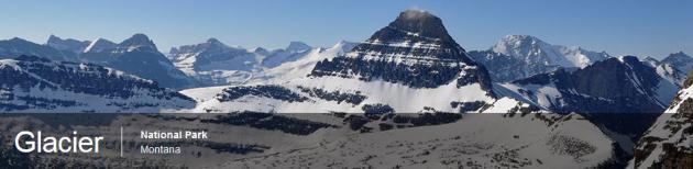
Climate Change Threatens To Strip The Identity Of Glacier National Park.
What will they call it when the glaciers are gone? Glaciers, along with
sea level rise, are a good proxy for long-term climate trends. Here's
an excerpt from
The New York Times: "...
A
century ago, this sweep of mountains on the Canadian border boasted
some 150 ice sheets, many of them scores of feet thick, plastered across
summits and tucked into rocky fissures high above parabolic valleys.
Today, perhaps 25 survive. In 30 years, there may be none. A warming climate is melting Glacier’s glaciers, an icy retreat that promises to change not just tourists’ vistas, but also the mountains and everything around them..."
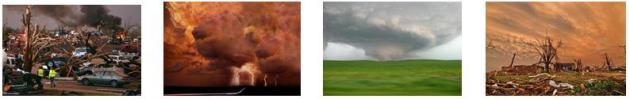
Half of Americans Think Climate Change is a Sign Of The Apocalypse.
The Atlantic has the article - here's an excerpt: "
Snowmageddon, snowpocalypse, snowzilla, just snow. Superstorm Sandy, receding shorelines, and more.
Hurricanes Isaac, Ivan, and Irene, with cousins Rammasun, Bopha, and
Haiyan. The parade of geological changes and extreme weather events
around the world since 2011 has been stunning. Perhaps that's part of
why, as the Public Religion Research Institute reported
on Friday, "The number of Americans who believe that natural disasters
are evidence of the apocalypse has increased somewhat over the past
couple years..."
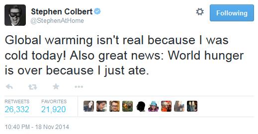
Tired Of The Cold Weather Already? Blame Global Warming. A
mental disconnect, counterintuitive? Absolutely, but changes in the
rate of warming of the Northern Hemisphere, especially what's happening
in the Arctic, may be impacting jet stream configurations, pulling more
bitter air south in the process - frigid air that's passing over Great
Lakes considerably warmer than they were 50 years ago. Here's an excerpt
from
BetaWired: "...
In
the case of this week’s massive snowfall in regions of upstate New York
like Buffalo, the principal scientist for NOAA’s National Climatic Data
Center, Thomas C. Peterson, said that the Great Lakes were too warm
when the Canadian air of the cold front hit it. The interaction with the
warm water and the frigid air created a massive “lake effect” storm
that positively inundated the region; while lake effect snow does impact
the area every winter, Peterson said that if the Great Lakes would have
been cooler the record snowfall wouldn’t have occurred. But where did
the cold polar air come from in the first place? Scientists say that
rising temperatures cause the jet stream to shift." (Photo: New York State Police)
There's Growing Evidence That Global Warming Is Driving Crazy Winters. Here's an excerpt of a story from Chris Mooney at
The Washington Post: "...
According
to Francis, the extreme U.S. winter of last year and now, the extremes
at the beginning of this season, fit her theory. "This winter looks a
whole lot like last winter, it’s a very amplified jet stream pattern,"
she says. "We know that when we get these patterns, it tends to be very
persistent. And it is definitely the type of pattern that we expect to
see more often as the Arctic continues to warm so fast." To be sure,
Francis acknowledges that our recent bout of extreme cold was
kickstarted most directly by Typhoon Nuri, which swerved up into the mid-latitudes and exploded into an atmospheric bomb over the Bering Sea..."
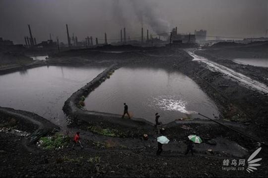
In Step To Lower Carbon Emissions, China Will Place a Limit on Coal use in 2020. While we "debate the science" China is taking action to lower their carbon emissions, which have now surpassed the USA's.
The New York Times has an article; here's the intro: "
China plans to set a cap on coal consumption in 2020, an important step for the country in trying to achieve a recently announced goal of having carbon dioxide emissions peak by around 2030. The State Council, China’s cabinet, released details of an energy strategy late Wednesday that
includes capping coal consumption at 4.2 billion tons in 2020 and
having coal be no more than 62 percent of the primary energy mix by that
year. Worldwide, coal burning for industrial use is the largest source
of carbon dioxide emissions, which are the biggest catalyst of global
climate change..."

No comments:
Post a Comment