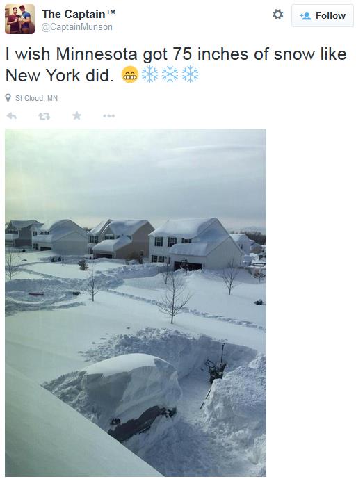
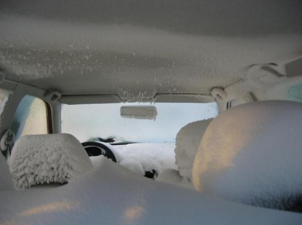
18 F. high in the Twin Cities Thursday.
38 F. average high on November 20.
45 F. high on November 20, 2013.
November 20, 2001:
Record highs were set in west and north central Minnesota with highs in
the upper fifties to lower sixties. Redwood Falls set their high with
68 degrees Fahrenheit and Little Falls had a high of 65 degrees.
November 20, 1980: On this date, around 28 thousand Canadian geese spent their nights on Silver Lake in Rochester.
Cold Turkey
Think
of the 7-Day as good incentive to bulk up to your winter weight. Go for
that extra slice of pumpkin pie! What I lack in warmth & sunlight I
plan to make up for in sugar and cool calories.
Welcome to the
11th day in a row below freezing; typical for January - a bit unusual
for November. No match for 1874-75, when the Twin Cities enjoyed 83 days
in a row colder than 32F. Ouch.
A few friends are freaking out,
huddled in their weather bunkers, expecting another winter identical to
last year. It may be more prayer than prediction but I still think we'll
see more variability, more swings in temperature.
El Nino appears
to be strengthening in the Pacific, increasing the odds of milder air
pushing into the western half of the USA from time to time, reducing the
odds of another perpetual polar vortex blocking pattern similar to last
winter.
Place your bets.
We finally thaw out Saturday. Rain
stays to our east on Sunday - a snowy coating Monday. The risk of snow
on Thanksgiving has dropped off a bit; there may be too much cold air
pushing the storm track well south of Minnesota. A cold smack late next
week gives way to 30s, even a few 40s the first week of December.
Get ready for some BIG ups and downs over the next 3+ months.
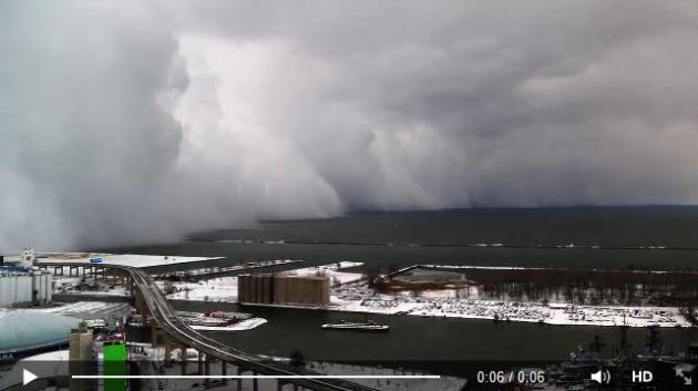
Serious Lake Effect.
This brief time lapse of the snow squalls rolling across the south side
of Buffalo is pretty amazing. I can't recall ever seeing such a sharp
cut-off, almost resembling the edge of a line of severe summer T-storms.
Details via Facebook: "This
may be the coolest thing you see all week. Video from downtown Buffalo
looking south toward the monster lake effect snow band over Lake Erie." (Courtesy: Joseph De Benedictis and Jason Holler).
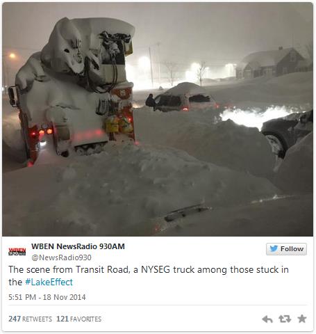
Snowstorm Again Pounds Western New York. Here's an excerpt of an update from
The New York Times: "...
The
snow fell so fast that it quickly packed into a solid mass, making
plowing impossible. The only option is to use heavy machinery to pick up
snow and haul it away, a slow, grinding effort. But unlike a typical
winter storm, the snow caused by the “lake effect” — in which cold, dry
winds sweep across bodies of warmer lake water — was not felt equally
across the region. The divide was so stark that someone on a tall
building in downtown Buffalo had clear skies overheard but could see a
menacing gray wall of moisture and snow swept up off the lake and driven
south..."
 Unraveling The Mysteries of Deadly "Firehose" Lake Effect Snow Events
.
Every lake effect snow event is different, but what are the ingredients
that go into historic snowfalls? Are lake effect snows downwind of Erie
and Ontario some of the heaviest on earth? Andrew Freedman has a
fascinating story at
Mashable; here's an excerpt: "...
Jim
Steenburgh, a meteorology professor at the University of Utah, said the
Buffalo storm's first round confirms some of what he and his colleagues
observed in high-resolution last year. These storms can have a
“structure that’s really incredible… a structure that you sometimes see
with severe thunderstorms,” he told Mashable. From Tuesday through
Wednesday, the narrow band of heavy snow that targeted towns such as
West Seneca, New York, on Tuesday night, was barely 15 miles wide but
more than 100 miles long. In chilling photographs, it resembled a wall
of snow more closely akin to a broiling dust storm than a snow squall..."
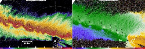
Image credit above: "
Radar
imagery from the Doppler on Wheels (DOW) mobile radar, operated by the
Center for Severe Weather Research, collected during the NSF-sponsored
OWLeS project. Left panel is radar reflectivity (length scale is added);
Right panel is Doppler velocity. Arrows show location of small
vortices. X marks location of radar." Image: Karen Kosiba/CSWR.
Global Warming Is Probably Boosting Lake Effect Snows. Here's an excerpt of an excellent article from meteorologist Eric Holthaus at
Slate,
showing how a gradual warming trend (and less ice cover) is creating
conditions more favorable for more lake effect snows: "...
Another massive early-season lake-effect event occurred in Buffalo back in October 2006,
when Lake Erie water temperatures were even warmer than they were this
week. Almost a million people lost power. Lake Erie is warming (along
with the rest of the planet) by a steady but measurable amount.
Since 1960 that trend has been about a half of a degree Fahrenheit per
decade. More important than this, though, Lake Erie has been losing its
ability to freeze over in the winter, with a decline of about one
sub-freezing day per year in recent decades..."
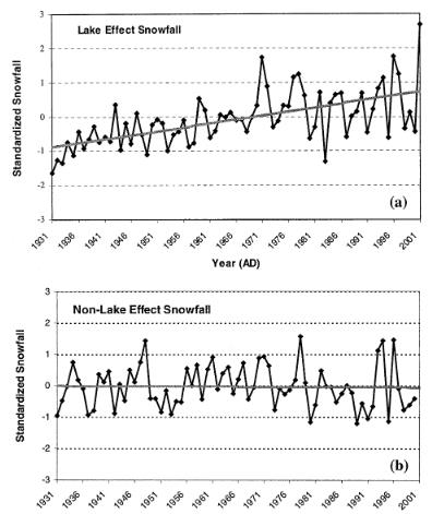
* graphic above from a 2003 paper by Burnett, et all available via PDF
here.
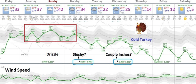
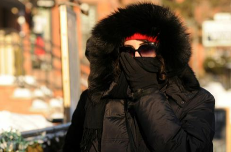
Weekend Thaw, Then (Very) Cold Turkey.
Although not as cold as January or February, temperatures dip into the
teens again late next week with a chance of subzero lows Friday morning.
Make the most of 40F warmth Sunday (the best chance of rain stays east
of Minnesota, but a little drizzle or very light rain is possible). A
coating of snow is possible Monday, maybe an inch or two of powder
Wednesday as a reinforcing clipper arrives. Behind that next swirl of
low pressure temperatures tumble in time for a brisk shopping experience
on Black Friday.
Lake Effect Fire-Hose Shuts Off, For Now.
Residents of Buffalo are pleading for mercy, and icy winds begin to
ease a bit today and Friday; in fact temperatures rise into the 50s by
Monday across western New York, sparking flooding concerns. A Pacific
storm spreads heavy snow into the higher terrain of Washington state,
Idaho, Montana and Utah's Wasatch Range within 36-48 hours. Source: NOAA
and HAMweather.
Southern Surge.
Soaking rains push across northern California and much of the Pacific
Northwest, another developing storm sending a streak of heavy rain from
Texas right up the Mississippi River Valley toward Wisconsin, Illinois
and Michigan over the weekend. 4 km NAM guidance: NOAA and HAMweather.
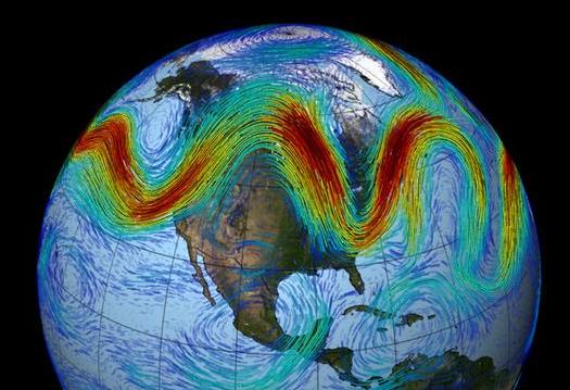
Freezing On East Coast? Blame a Super Typhoon and Maybe Global Warming.
Ex-Typhoon Nuri helped to energize the jet stream as it curved to the
north last week, speeding up and amplifying jet stream steering winds,
building a massive, record-setting (5.5 sigma) ridge of warm high
pressure over Alaska and the Arctic; this buckling of the jet stream
plunging polar air southward into the USA. Here's a clip from a story at
NBC News: "...
The
cold front this month, however, appears to have a different birth. The
events "started with exceptionally warm sea temperatures in the Pacific
that led to the super Typhoon Nuri," says Kevin Trenberth, an
atmospheric scientist at NCAR. On Nov. 8, the typhoon became "incredibly
intense … advanced to the north and brought very warm air up into
Alaska and into the Arctic." "The cold air had to go somewhere else and
it did: down across the U.S.," says Trenberth. "By Nov. 12 the very cold
air over North America was matched by very warm air over Alaska and the
Arctic..."
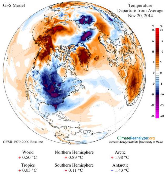
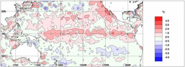
Temperature anomalies
(departure from average) for November 20 obtained using Climate
Reanalyzer (http://cci-reanalyzer.org), Climate Change Institute,
University of Maine, USA.
Tropical Pacific Ocean Moves Closer to El Nino. The odds of an El Nino have risen to 70% according to Australia's
Bureau of Meteorology; here's an excerpt of a recent release: "
The
Pacific Ocean has shown some renewed signs of El Niño development in
recent weeks. Above-average temperatures in the tropical Pacific Ocean
have warmed further in the past fortnight, while the Southern
Oscillation Index (SOI) has generally been in excess of El Niño
thresholds for the past three months. Climate models suggest current
conditions will either persist or strengthen. These factors mean the
Bureau's ENSO Tracker Status has been upgraded from WATCH to ALERT
level, indicating at least a 70% chance of El Niño occurring..."
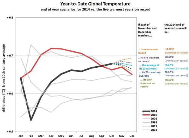
2014: On Track For The Warmest Year, Worldwide, On Record?
It may be close, but what makes this even more unusual is that 2013 and
2014 weren't El Nino years, no Pacific warmth turbocharging the
atmosphere. Here's an excerpt from
NOAA NCDC: "
The
years 2013 and 2014 are the only years on this list not to begin during
a mature El Niño event. The years 1998 and 2010, each of which became
the warmest year on record at the time, ended the year in a strong La
Niña event, as evidenced by the relative fading of global average
temperature later in the year. The anomalies themselves represent
departures from the 20th century average temperature. The graph zooms
into the warmest part of the entire history. For a broader perspective
on how these five years relate to the long-term record, click here..."
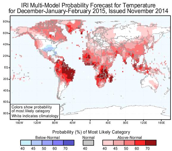
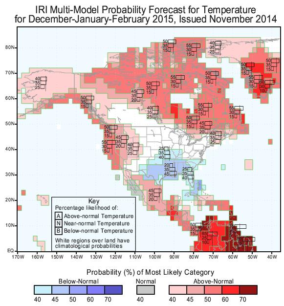
Winter Outlook from Columbia University. This is from
The International Research Institute
for Climate and Society, at Columbia Unversity's Earth Institute. Of
course all long-range seasonal outlooks should be taken with a big grain
of salt, but I couldn't get over how much red (warmer than average) is
predicted for the planet from December into February.
Average Winter Temperatures for Minnesota? It's too early to celebrate, but at least one longer-range climate model from
Columbia University
is forecasting a notable lack of polar air for much of North American
from December into February; warmer for much of the western USA
(consistent with a developing El Nino), warmer for much of Canada, the
Arctic and Greenland, colder than average for the southern USA.
NOAA: Globe Sets 5th Hottest-Month Record of 2014.
Some temperature "pause". The eastern USA has had a chilly year, but
that's more than compensated for by the rest of the planet, on it's way
toward what may be the warmest year on record. The 6 warmest months on
record for global ocean water temperatures have been in the last 6
months. Here's an excerpt from the AP and
wsbtv.com: "
Despite
a bitter U.S. cold snap, the globe is rushing hell-bent toward its
warmest year on record with last month setting the fifth monthly heat
record of year. The National Oceanic and Atmospheric Administration
announced Thursday that last month was the hottest October on record
worldwide. The 58.43 degrees Fahrenheit (14.74 Celsius) beat out October
2003. "It is becoming pretty clear that 2014 will end up as the warmest
year on record," said Deke Arndt, climate monitoring chief for NOAA's
National Climatic Data Center in Asheville, North Carolina. "The
remaining question is: How much?..."
How To Protect Your Phone In Cold Weather. Here's an excerpt of a
CNN story that made me do a double-take: "...
Some smartphones list the optimum range of temperatures in their technical specs. For example, when it's turned off, the iPhone 5S
can withstand temperatures between -4° and 113° Fahrenheit. When it's
turned on, the range is much more narrow. Apple suggests 32° Fahrenheit
as the lowest operating ambient temperature. Other phones are rated for
much lower temperatures, and some can go as low as -4° Fahrenheit while
in operation..."
Are Our Buildings Prepared For Natural Disasters Bigger Than Hurricane Sandy?
Technically Sandy wasn't even a hurricane when it hit coastal New
Jersey on October 29, 2012, rather a massive mash-up of nor'easter and
ex-hurricane. Is New York City better prepared? Here's an excerpt of a
story at
The Guardian: "...
What
if you have Sandy, but it’s an actual hurricane, with hurricane-level
winds? The first generation of skyscrapers was not designed for
windloads. So would we see facades being pulled off in Midtown
Manhattan? That’s something we don’t understand yet. We recommended the city study this, and legislation passed
– the results of their study is due on October 2, 2015. Also, in a
modern city, everyone’s reliant on power – and all the more so in a
vertical city. We’ve facilitated a change that makes it easier to
install backup generators, but what happens if we get two weeks without
power next time instead of a week?..." (Image above: NOAA).
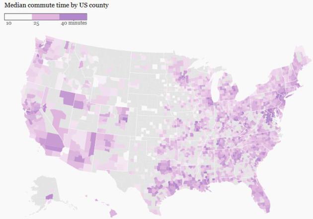
America's Toughest Commutes, Charted. I love
Quartz's information-dense maps - here's an excerpt of a story focused on commute times across the USA: "...
But it turns out that of the 20 counties with the longest commutes, nine are among the 100 wealthiest counties in the US.
And where are all the well-off commuters going? Washington, DC. When we
only look at the 100 wealthiest US counties, 13 of the 20 longest
median commutes are in the Washington area. The remainder of the list is comprised of counties in the New York, Chicago, Denver, and San Francisco areas..."
Map credit above: Quartz. Data: 2013 American Community Survey.
TODAY: Clouds increase, not as cold. Winds: S 15. High: near 30
FRIDAY NIGHT: Mostly cloudy, not as chilly as recent nights. Low: 28
SATURDAY: First thaw in 12 days. Gray skies - not as numb. High: 38
SUNDAY: Cloudy, chance of drizzle. Wake-up: 32. High: near 40
MONDAY: Coating of flurries, light snow. Wake-up: 29. High: 33 (falling)
TUESDAY: Clearing skies, chilly again. Wake-up: 16. High: 22
WEDNESDAY: Inch or so of snow showers? Wake-up: 13. High: 26
THANKSGIVING: Feels like January again. Mostly cloudy. Wake-up: 5. High: 18
Climate Stories...
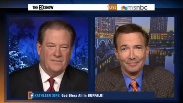
Did Climate Change "Juice" The Buffalo Snow Amounts?
Water temperatures in Lake Erie were in the low to mid 50s earlier this
week, almost 50F warmer than the air passing overhead. There's
considerable evidence that warmer water in the Great Lakes is resulting
in more extreme lake effect snow events earlier in the season than 30-50
years ago. What influence did climate volatility play in the
(incredible) snowfall amounts and snowfall rates since Tuesday. I had a
chance to chat with Ed Schultz at MSNBC Thursday; the clip is
here.
There's Growing Evidence That Global Warming Is Driving Crazy Winters. Here's an excerpt of a story from Chris Mooney at
The Washington Post: "...
According
to Francis, the extreme U.S. winter of last year and now, the extremes
at the beginning of this season, fit her theory. "This winter looks a
whole lot like last winter, it’s a very amplified jet stream pattern,"
she says. "We know that when we get these patterns, it tends to be very
persistent. And it is definitely the type of pattern that we expect to
see more often as the Arctic continues to warm so fast." To be sure,
Francis acknowledges that our recent bout of extreme cold was
kickstarted most directly by Typhoon Nuri, which swerved up into the mid-latitudes and exploded into an atmospheric bomb over the Bering Sea..."
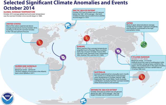
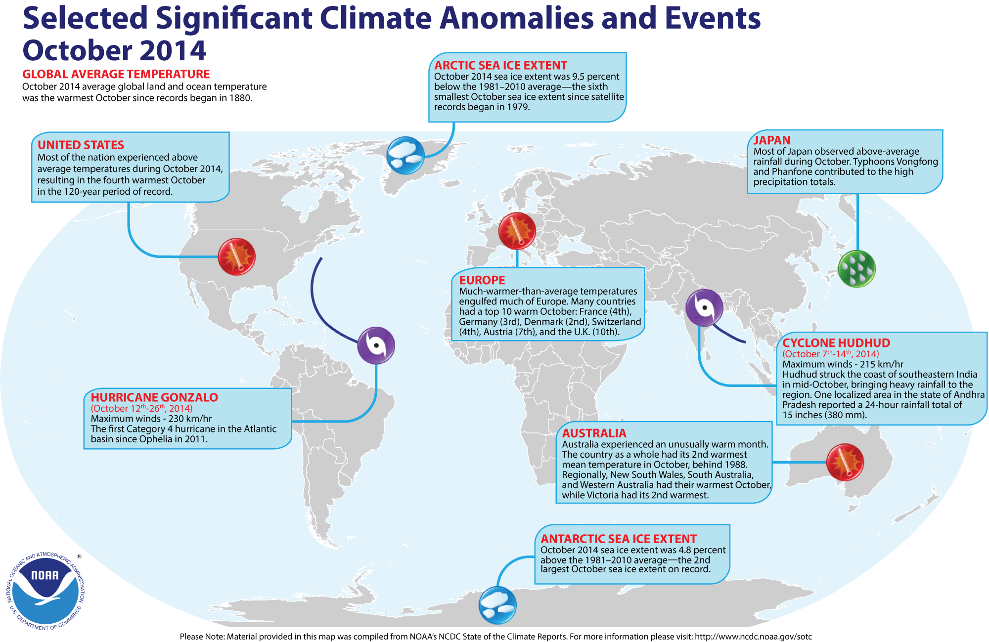
Significant Global Climate Anomalies and Events in October. NOAA NCDC has the high-resolution graphic with more details
here.
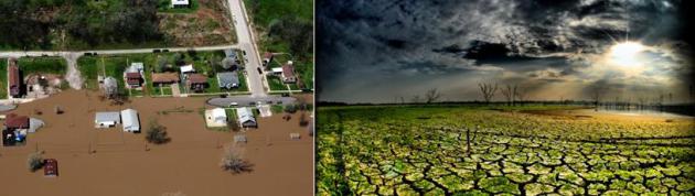
Climate Change To Increase Flood, Crop Insurance Losses.
USA TODAY has the story - here's an excerpt: "...
For
agriculture, the report cites research that predicts changes in
temperature and precipitation can be offset over the next 25 years by
technological advancements, expansion of irrigation and shifts in crop
production. But by mid-century, weather and precipitation extremes could
intensify and cause yields and farm profits to decline, despite these
adjustments..."
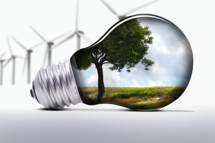
States Can Bring Clean Energy to 21st Century. Here's an excerpt of an Op-Ed at
The Hill
that resonated. Many of the new, disruptive energy alternatives are
also zero-carbon, and they're scaling up faster than predicted: "...
The
U.S. electric power system is facing serious challenges today, with
innovations disrupting old ways of doing business, infrastructure
showing its age and customers looking for new forms of service.
Fortunately, we have the tools to address these challenges: demand
response to maintain reliability at times of peak load; combined cycle
natural gas to provide flexible electricity generation; solar power and
wind power for zero emission generation with no fuel cost; more
efficient lighting, appliances and industrial motors that use less
energy and reduce demand; and smart meters to provide better data and
more control for consumers. In short, we have more ways to make, manage
and use electricity than ever before — and many of these technologies
also reduce carbon emissions..."
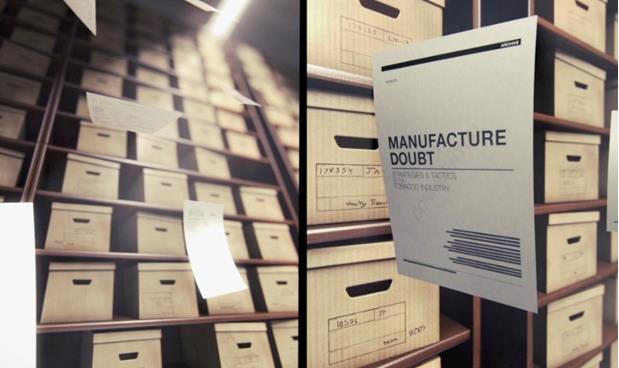
"Merchants of Doubt" Film Exposes Slick U.S. Industry Behind Climate Denial. The Guardian has details; here's an excerpt: "...
With the 9/11 attacks on the World Trade Center occupying attention, Americans For Prosperity,
a powerful, fossil-fuel lobby group founded by the billionaire Koch
Brothers, launched a decade-long, multi-pronged campaign to sow doubt
about the reality of climate change. By equating the findings of climate
scientists as an attack on personal freedoms, they cleverly shifted the
focus away from science to political opinion. “Creating a focus point
away from what is actually going on is how magicians pull off their
tricks,” said Kenner who directed the Oscar-nominated documentary Food Inc. The deception has worked well. Few Americans know 97% of scientists agree climate change is caused by human activity and is happening now..."
Photo credit above: "
Robert
Kenner’s documentary Merchants of Doubt looks at professionals working
for the fossil fuel industry to sow doubt in the US climate change
debate." Photograph: Sony Pictures Classics.
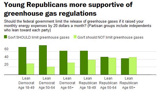
A GOP Generation Gap on Climate Change, Similar to Gay Marriage?
Chris Mooney takes a look at a growing gap between younger and older
Republicans and their expectations about curtailing greenhouse gases at
The Washington Post; here's the intro: "
Congressional
Republicans want to make fighting the Environmental Protection Agency's
climate regulations and President Obama's greenhouse gas reduction
targets a centerpiece of their agenda over next two years -- now that
they have wrested control of the Senate as well as House. But how will
the politics of that look 10 years from now? Several commentators have suggested that climate change could become the gay marriage issue of the future for the GOP..."
Graphic credit above:
Washington Post-ABC News poll - Click for details
Dear Snow Trolls: Winter Weather Does Not Refute Global Warming. The Washington Post hosts an obligatory story about the difference between weather and climate; here's an excerpt: "...
Indeed,
much evidence suggests that we may be experiencing this stark cold
while en route to the warmest year in recorded history. Just recently we
learned
that at least according to data from the Japan Meteorological Agency
(which may soon be confirmed by the National Oceanic and Atmospheric
Administration), October 2014 on a global level was the hottest October
on record. And even before we knew what October's temperatures looked
like, NOAA had shown that there was a very good chance of 2014 setting an overall temperature record...."
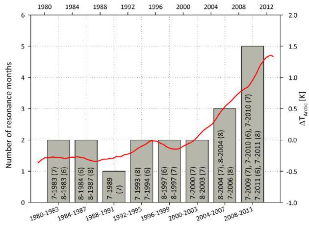
More Frequent Wave Resonance in the Atmosphere.
The number of planetary wave resonance events (which lead to
exceptional weather extremes) is shown as grey bars for each 4-year
intervals. For comparison the red curve shows the change in Arctic
temperature relative to that in the remainder of the Northern
Hemisphere. Rapid Arctic warming since 2000 could explain the increasing
number of weather extremes. Source: Coumou et all, PNAS 2014.
The Moral Issue of Climate Change.
Climate change is a moral and even a spiritual issue, as much as a
scientific and economic issue. Here's an excerpt of a David Ignatius
Op-Ed at
The Washington Post that caught my eye: "...
They
reject or minimize the arguments of leading scientists that such
emissions are directly linked to global warming and climate change and
could have catastrophic long-term consequences. The doubters question
the data, to be sure. But their basic argument is political: Action to
protect the environment will hurt “my state.” But what if the climate
change problem were instead treated as a moral issue — a matter like
civil rights where the usual horse-trading logic of politics has been
replaced by a debate about what’s right and wrong?..."

No comments:
Post a Comment