36 F. high in the Twin Cities Tuesday.
24 F. average high on January 27.
-6 F. high on January 27, 2014.
-16 F. morning low on January 27, 2014.
Trace of snow on the ground in the Twin Cities.
January 27, 1914: A very rare thunderstorm observed at Maple Plain during the evening. Heavy thunder and vivid lightning was observed.
January 27, 1846: Not too shabby for a January day. The high in the Twin Cities was 50, which is the normal high for the beginning of March.
The Grand Illusion
With
apologies to the rock band Styx - I'm talking about a different
illusion here. Recent years have brought a meteorological arms race: new
weather models, higher resolution, more petaflops! Here is what I hear
all the time:
"Paul, you blinking meathead, you have access to
supercomputer and Doppler radar. You SHOULD be able to tell me exactly
how many inches of snow will fall in my yard!"
In theory, yes. In reality, not even close.
Private
and government (NOAA) forecasters in New York and Boston are under
siege for overestimating Monday night's snowfall amounts. In their
defense even the ECMWF (European) model busted. Total amounts ranged
from 8 inches at Central Park to 21 at Sayville, Long Island, only 50
miles due east. I'm not sure weather models will ever able to
effectively pinpoint such extremes over such a small geographical area.
Weather isn't an exact science, like economics or foreign policy.
After
brushing 40F today we cool off Thursday; weekend snow passing south of
Minnesota. A whiff of subzero air is expected on Groundhog Day, an even
colder slap by the end of next week.
But no sign of polar air stalling nearby. Another Pacific thaw is shaping up for the second week of February.
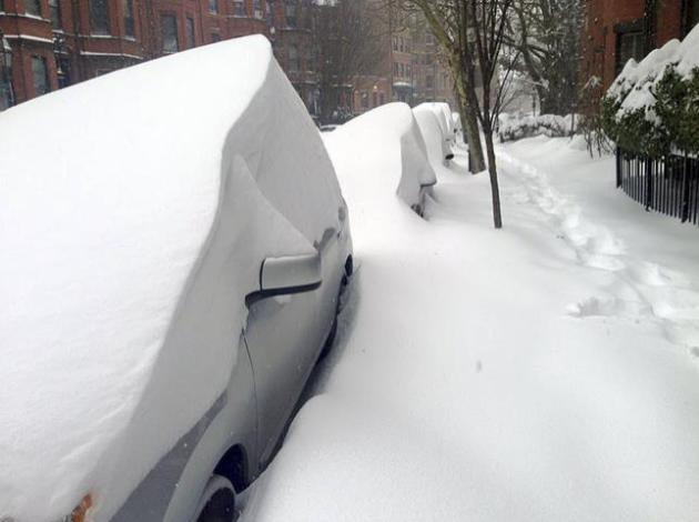
20-30" snow for metro Boston. The forecast verified for Bean Town; details from
CBS Boston. Photo credit: "
Cars
are buried by drifted snow along Marlborough Street, Tuesday, Jan. 27,
2015, in Boston. A howling blizzard with wind gusts over 70 mph heaped
snow on Boston along with other stretches of lower New England." (AP Photo/Dwayne Desaulniers).
Snowstorm's Forecast Was Mostly Right, Even If It Felt Wrong In New York.
Manhattan was on the western edge of the heaviest snow bands; 40 miles
made the difference between 8" and 21". Here's an excerpt from
The New York Times: "...
One
of the difficulties with forecasting major storms, Dr. Sobel said, is
that a small error in predicting the path of the storm can cause a much
larger error in impact. “The bigger the event, the bigger the bust
potential,” he said. In this storm, the predicted snowfall gradients —
charts showing how much would accumulate where — were very steep. “So a
little bit of track error means a big snowfall error,” he said..."
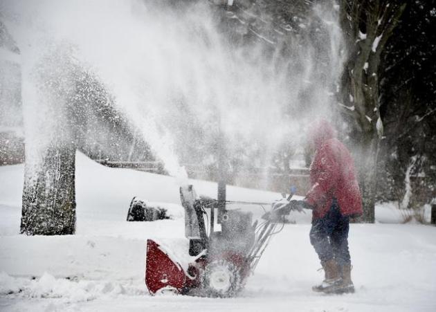
Photo credit above: "
Snow
swirls into the air as Ted Diamond operates a snow blower to clear out
his driveway on Greenvale Drive in East Northport on Tuesday, Jan. 27,
2015, in New York. Long Island was one of several areas throughout the
state to be hit by a blizzard overnight into this morning." (AP Photo/Kathy Kmonicek).
Partly Wrong With A Chance of Being Right: Weather Forecast. Why do weather models fail? In light of the Big Bust out east I wanted to include a link to a storyy at
ScienceDaily; here's an excerpt: "...
For
example, they found that in the eastern Mediterranean, particles in the
atmosphere were the most important cause of forecast fallacies,
followed by land cover change. They also found topography to be the most
influential factor affecting weather around the world. "The only tool
the weather forecaster has is his model, and the only choice he or she
has is to look at different models, each of which has strengths and
weaknesses," said Prof. Alpert..."
What Exactly Is A Nor'easter? Newsweek has a good description; here's an excerpt: "...
A
classic nor’easter results when an existing low-pressure system moves
across the country from west to east and then spawns a new storm off the
East Coast, usually between the Carolinas and New Jersey, explains
Keith Seitter, executive director of the American Meteorological
Society. The initial storm may not have produced a huge amount of
precipitation as it moved over land, but the new storm goes through an
“explosive development,” says Seitter, and becomes a “monster storm”
that absorbs the original one..."
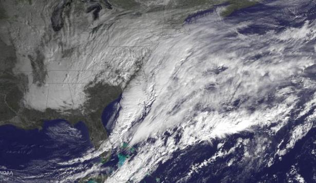
Image credit above: "
A
winter storm approaches the eastern United States in a satellite image
released January 26, 2015. The National Weather Service has issued a
blizzard warning for New York City and surrounding areas between coastal
New Jersey and Connecticut, beginning 1 p.m. EST on Monday. The storm
will worsen overnight into Tuesday morning." NOAA/Reuters.
 Snow Scary
.
The New Yorker has a terrific article that helps to explain why the USA is a nation of extreme-weather junkies; here's a clip: "...
Edgework”
is precisely what extreme weather is. A winter storm—or any storm,
really—approximates this thrill. It’s powerful, and even dangerous. But
safely ensconced inside, and in front of our computer screens, we don’t
think that it will really hurt us. The power might go out, but
then we would be able to share a picture of a car buried in a snowdrift.
And then, soon, it will be over. You will have had the thrill, and you
might have gained control over it by capturing a moment of “danger,”
but, in all, it seems a relatively minor risk. We satisfy our inner
risk-seeker without going into dangerous territory..."
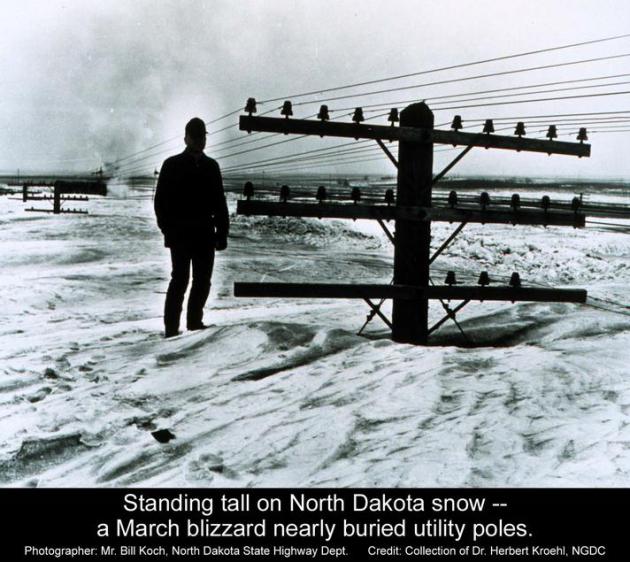
7 Chilling Stories Of Snow Storms Throughout American History.
TIME Magazine takes a numbing walk down memory lane; here's a clip: "...
It was Jan. 31, 1977, when this poor freezing man appeared on the cover of TIME. The story inside,
which detailed the effects on the United States of what the publisher’s
letter called “the bitterest cold spell in memory.” The first-ever
reported snow fall in West Palm Beat, Fla., had shocked residents.
Buffalo had been buried under more than 120 in. of the white stuff that
season. And, ironically, areas that needed snow — the ski resorts of
Idaho, for example — had to rely on snow-making machines despite the
cold temperatures...
Photo credit: Bill Koch, North Dakota State Highway Department. Credit: Collection of Fr. Herbert Kroehl, NGDC.
"
Snowstorms Then And Now". McSweeney's Internet Tendency has a look at how adults have ruined snowstorms.
It's a worthy (and funny) read.
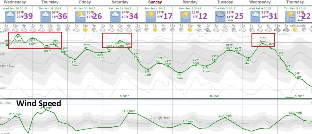 Cold Start to February - Not Polar Yet
.
I keep waiting for the other shoe (boot) to drop, and it may the end of
next week; ECMWF guidance hinting at subzero weather in about 8-10
days. We'll see - we've had a few false alarms in the last few weeks so
confidence levels are low about any kind of sustained cold waves. Highs
may brush 40F today before cooling off tomorrow; the mercury nicking
freezing again Saturday and Wednesday of next week. Big storms? Get
serious. Graphic: Weatherspark.
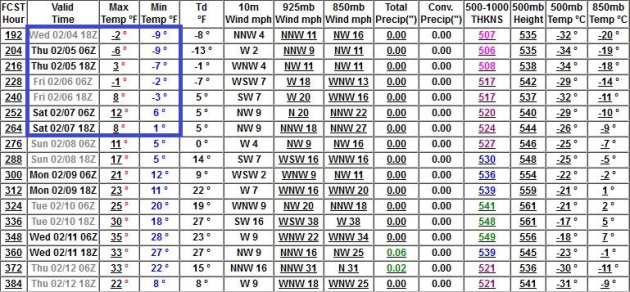 GFS Numbers
.
GFS guidance also confirms that the first week of February may be
colder than average with a few nights dipping below zero. Most models
show another puff of Pacific air sparking another thaw by the second
week of February.
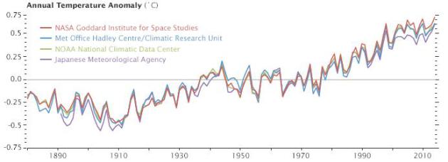
Why So Many Global Temperature Records? NASA Earth Observatory
has a good explainer focused on 2014 being the warmest year ever
observed, as well as providing perspective of recent trends; here's a
clip: "...
But let’s get back to the original question: why are there
so many temperature records? One of the hallmarks of good science is
that observations should be independently confirmed by separate research
groups using separate methods when possible. And in the case of global
temperatures, that’s exactly what is happening. Despite some differences
in the year-to-year rankings, the trends observed by all the groups are
roughly the same. They all show warming. They all find the most recent
decade to be warmer than previous decades..."
Millions of GMO Insects Could Be Released in Florida Keys.
The Associated Press has the story - here's the introduction: "
Millions
of genetically modified mosquitoes could be released in the Florida
Keys if British researchers win approval to use the bugs against two
extremely painful viral diseases. Never before have insects with
modified DNA come so close to being set loose in a residential U.S.
neighborhood..."
Patriots Say Study Proves Ball Deflation "Not Human Caused". Where have you heard this before? Here's the intro to a tongue-in-cheek look from
Daily Kos: "
The
New England Patriots pointed to a study released today which they say
shows that the alleged deflation of footballs in recent games was not
due to human causes. "It's just natural variation," explains the
executive summary of the study. "Footballs have had different inflation
pressures for thousands of years." The study was released today by the
Edelman research firm, which usually focuses on swatting away the
damaging efforts of environmentalists to impede progress..."
 Is It OK To Eat Snow?
 I know this has been on your mind; here's an answer from
Popular Science: "...
Once
the snow is on the ground, it stays clean until other things land on
top of it. Everyone knows you shouldn’t eat yellow snow. Brown snow is
off limits, too. That’s because as snow sits around, it goes through a
process called dry deposition, in which dust and dirt particles stick to
the snow. And Nolin says to steer clear of watermelon snow: It might look pretty and very pink, but it’s filled with algae that don’t do great things for digestion..."
TODAY: Mostly cloudy and mild. Winds: Southeast 10. High: 40
WEDNESDAY NIGHT: Clouds, still unseasonably mild for late January. Low: 30
THURSDAY: Windy, turning cooler with more clouds than sun. High: 33
FRIDAY: Fading sun, average temperatures. Wake-up: 18. High: 27
SATURDAY: Gray with flurries possible south. Heavier snow should stay south of MN. Wake-up: 19. High: 30
SUNDAY: Brisk Super Bowl Sunday. Dry with plenty of sun. Wake-up: 15. High: 18
MONDAY: Blue sky. Groundhog's shadow may freeze off. Wake-up: 3. High: 12
TUESDAY: Not as cold, flurries possible. Wake-up: 10. High: 25
Climate Stories...
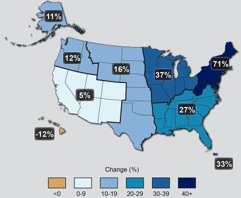
Why Bigger Snowstorms Come With Global Warming.
Warmer air and ocean water is increasing water vapor, more fuel for
flash floods in the summer months, and extreme snow events in the
winter. In fact 5 of New York City's biggest blizzards on record have
all occurred in the last 12 years. Here's an excerpt from a timely story
at
InsideClimate News: "...
As
the oceans warm due to the burning of fossil fuels, the atmosphere
above can hold more moisture, which in turn fuels the creation of the
most intense precipitation events. The mid-Atlantic is currently 2
degrees Fahrenheit above normal. In the spring, summer and fall, that
translates into more of the most intense rainstorms. In the winter, when
that moisture-rich air hits cold temperatures on the continent, heavier
snowfall results. The amount of rain and snow falling in the heaviest
precipitation events in the Northeast has jumped 71 percent in the last
half-century, according to the 2014 National Climate Assessment...."
Is Climate Change To Blame For The Northeast Snow Storm? The
short answer is no, the storm would have formed, with or without warmer
air and sea surface temperatures. Did significantly warmer water in the
Gulf Stream just east of New Jersey help to spike some of the winds and
snowfall amounts? Probably. Here's an excerpt from
Huffington Post: "...
Kevin
Trenberth, a senior scientist in the climate analysis section at the
National Center for Atmospheric Research, said that in winter,
temperatures are generally colder on land than over the oceans. Climate
change is raising ocean temperatures, however, and current sea surface
temperatures are more the 2 degrees Fahrenheit higher than normal over
much of the area off the East Coast of the United States, he explained
to The Huffington Post. Trenberth also said that water vapor in the
atmosphere is about 10 percent higher than normal, and about half of
this change can be attributed to climate change..."
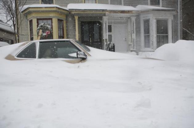
Photo credit: "
A
snow-entombed car in Cambridge, Mass., Jan 27, 2015. The first major
storm of the winter blasted across eastern New England on Tuesday,
unleashing whiteout conditions driven by gale-force winds." (Katherine Taylor/The New York Times).
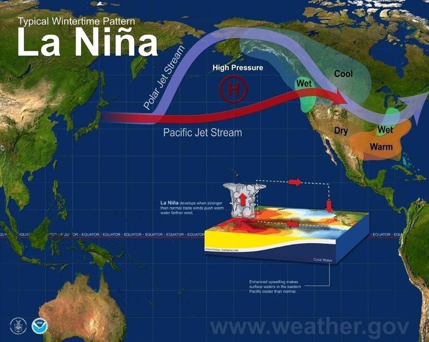 Climate Change Expected To Bring More Extreme La Ninas
. Here's an excerpt from a story at
CBS News: "...
A new study concludes that extreme La Nina
events like this will become twice as likely in the future due to
climate change. The study in Nature Climate Change found that the La
Nina extreme weather -- which happens about once every 23 years -- will
occur every 13 years by the end of this century, based on an analysis of
21 climate models. Three-quarters of those increased La Nina events
would follow extreme El Nino events "thus projecting more frequent
swings between opposite extremes from year to the next..."
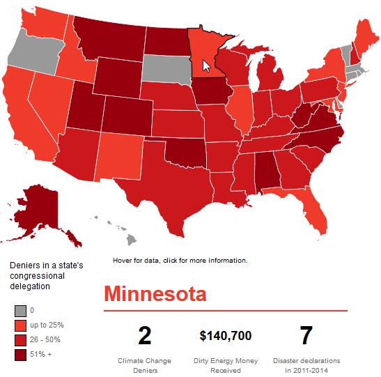
The United States of Denial.
Which states send the most climate-science-deniers to Washington D.C.?
Here's an excerpt of a story and interactive graphic from
onEarth: "...
An
analysis by the Center for American Progress, a public policy think
tank, found that 53 percent of Republicans in the House and 70 percent
in the Senate deny humanity’s role in climate change. (As the map shows,
deniers also tend to receive a pretty penny from the fossil fuel
industry.)..."
Climate-Change Consensus Is Reached Everywhere But In Washington. Here's a snippet from an Op-Ed that resonated at
The Globe and Mail: "...
This
is less like rearranging the deck chairs on the Titanic than looking
over the railing and debating whether the giant white thing is an
iceberg or a marshmallow. The consensus has been reached, gentlemen,
everywhere but in Washington. Even the plutocrats at Davos are sweating
through their Zegna suits: The World Economic Forum spent a day debating
climate change and its disruptive effects, and listed climate-related
chaos among the greatest threats facing the planet..."


No comments:
Post a Comment