23 F. average high on January 11.
32 F. high on January 11, 2014.
1/10th of an inch of snow fell at MSP International Airport yesterday.
4" snow on the ground.
January 11, 2000: Snow falls in a narrow band over the Twin Cities. Maplewood receives 5.5 inches, while Chanhassen gets 12.
January 11, 1888: "Blizzard of '88." It hit during a mild day when many children were heading home from school. They made up the majority of the 200 people that died. At the end of the storm the thermometer at St. Paul read -37.

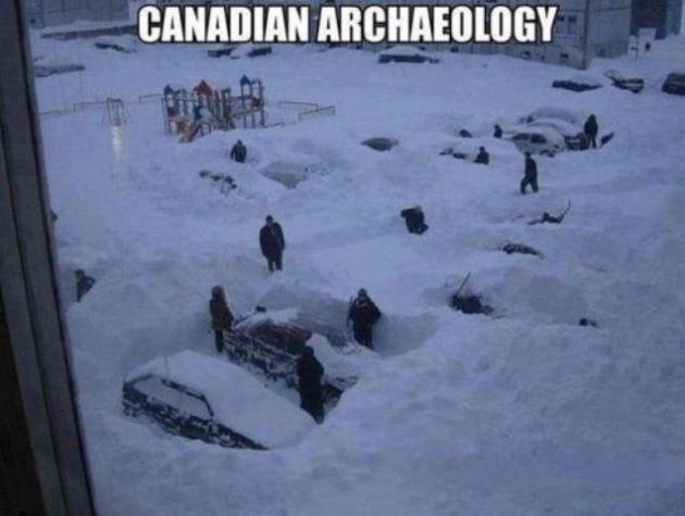
Coping Skills
How do you get through a Minnesota winter? Ask 100 people and you'll get 100 different opinions, suggestions and tips. Light boxes that mimic the sun and reduce the potential for SAD depression. More vitamin B. Investing in a pair of warm, waterproof boots, extra layers, a space heater, ear muffs AND a hat. MORE SOUP! And a remote-starting kit, so you can start your car while you're still in the office.
They all help, but perhaps nothing soothes a cruel, cryogenic winter like a southern trip in search of warm sunshine. Anywhere. And I now realize just the thought of a future getaway is almost as good as the trip itself.
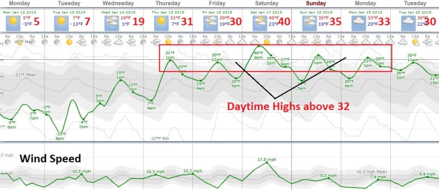
Sometimes the warm fronts come to you. After a week of subzero nighttime lows and windchills low enough to close schools and spark Facebook posts from concerned aunts I'm happy to report a streak of 30s Thursday into early next week. Thermometers may nudge 40F Saturday. Dripping icicles and sloppy puddles are 3-4 days away.
We cool off again next week but I still don't see anything even remotely resembling a "storm".
Snow lovers: don't panic yet, but with a brewing El Nino and more southerly storm track the odds of a 70-inch winter like last year are pretty small.
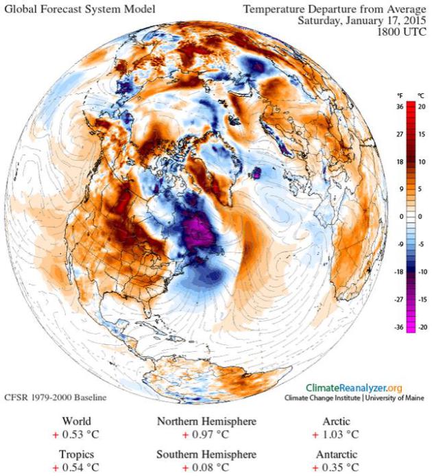
Image credit above: Temperature forecast above obtained using Climate Reanalyzer (http://cci-reanalyzer.org), Climate Change Institute, University of Maine, USA.
TODAY: The cold is getting old. Bright sun. Feels like -20. High: 5
MONDAY NIGHT: Clear and plenty cold. Low: -10
TUESDAY: Nippy start, fading sunshine by afternoon. High: 10
WEDNESDAY: More clouds, not nearly as numb. Wake-up: 3. High: 20
THURSDAY: Patchy clouds, welcome thaw! Wake-up: 10. High: 32
FRIDAY: Dripping icicles. We earned this. Wake-up: 21. High: 34
SATURDAY: Mild start, clouds build. Wake-up: 24. High: 39
SUNDAY: Still gray, above average temps. Wake-up: 22. High: 35
Climate Change

Climate Change Messing With Mother Nature's Time Table. Here's the intro to an interesting story at Climate Central: "In nature, timing is everything. From the mass migration of monarch butterflies to the simultaneous seminal release of corals to
the collective deaths of salmon and cicadas, many species stick to
schedules so strict, their habits could be used to mark the seasons.
Unfortunately, more and more evidence suggests that climate change has
already begun to cuss up these timetables. Some flowers,
for example, seem to be adapting more quickly to global warming than
the wild bumblebees they rely on for reproduction. The flowers bloom
earlier, often before the bees have emerged to transport pollen between
them. As a result, the plants produce fewer seeds..."
Photo credit: Tarnya Hall/flickr.
Climate Change Takes a Village. Villages in Alaska are on the leading edge of climate change, as described at Huffington Post; here's an excerpt: "...The
remote village of 563 people is located 30 miles south of the Arctic
Circle, flanked by the Chukchi Sea to the north and an inlet to the
south, and it sits atop rapidly melting permafrost. In the last decades,
the island's shores have been eroding into the sea, falling off in
giant chunks whenever a big storm hits. The residents of Shishmaref,
most of whom are Alaska Native Inupiaq people, have tried to counter
these problems, moving houses away from the cliffs and constructing
barriers along the northern shore to try to turn back the waves..."
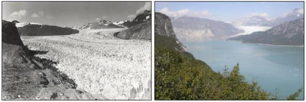
Image credit above: "In
an undated handout photo, the Muir Glacier in Glacier Bay National Park
and Reserve in Alaska on Aug. 13, 1941, left, and on Aug. 31, 2004.
With every day, it seems, comes new evidence that the thawing of the
world's glaciers and ice sheets of Greenland and Antarctica is
accelerating and may have reached a point of no return." (Glacier Photograph Collection via The New York Times).

Conservatives Don't Hate Climate Science - They Hate The Left's Climate Solutions.
Because they invariably involve a much larger federal government and
top-down solutions. Because "the cure is worse than the disease", right?
Here's a clip from an interesting story at The Washington Post: "...A
similar result, incidentally, has been found by Yale researcher Dan
Kahan and his colleagues: Framing climate solutions around either nuclear power or geoengineering
(artificial interference with the climate system in order to slow the
rate of warming, a technological fix) also seems to make conservatives
more accepting of climate science. This is presumably because these
solutions are also perceived as being based on the free market and
individual ingenuity, rather than a command and control government
regulatory approach..."
No comments:
Post a Comment