By Todd Nelson
"Polar Vortex" could have, quite literally, been the buzz word of 2014. While the term often found itself in the midst of controversy within the weather and scientific community as being used incorrectly or not, It caught on like wildfire throughout the media and spread to water coolers near you. The infectious phrase rolled out of the mouths of many as a way to try to describe the cold weather that burrowed into the eastern U.S. for much of 2014.
A recent report released by NOAA's NCDC said that globally, 2014 was the warmest year on record! There were only a few locations that had below average temperatures and one of those locations was the eastern half of the U.S.
Despite the recent mild weather over the past couple of days, January temperatures in Minneapolis are running nearly 5F below average. Keep in mind that this is, on average, the coldest time of the entire year! I am happy to report that we may sneak out of this climatological minimum with temperatures running slightly above average.
Enjoy it; extended model runs are suggesting another potential cold blast by the end of the month. Hang in there... Meteorological winter is already half over!
==============
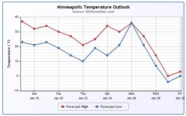
SATURDAY NIGHT: Breezy. Decreasing clouds. Low: 24. Winds: WNW 15-30mph, easing after midnight.
SUNDAY: More sun southern MN, still above average. High: 32. Winds: W 5-10
SUNDAY NIGHT: Clouds thicken. Low: 23.
MONDAY: More clouds than sun. Drippy. Light snow possible overnight. High: 34
TUESDAY: Light snow early, breezy. Wake-up: 24. High: 31
WEDNESDAY: Another clipper, light snow chance. Wake-up: 20. High: 27
THURSDAY: Light snow drifts south, cooler.. Wake-up: 12. High: 20.
FRIDAY: Partly sunny, light mix north late. Wake-up: 11. High: 25.
SATURDAY: More clouds, few flakes. Wake-up: 13. High: 28.
================
This Day in Weather History
January 18th
1996: Blizzard begins across the upper midwest. The Twin Cities Airport was spared the heavy snow, but received nearly one inch of rain. Heavy ice coatings in the northwest metro caused thousands of power outages. Windchills were as low as -88 (on the old windchill scale) at Crookston. Snowstorm totals were 18 inches at Ely, 12 inches at St. Cloud. Mail delivery was stopped for the day in Duluth and I-94 was closed all day from Rothsay and Moorhead. Flooding problems were caused in the Twin Cities due to backed up water.
1994: Governor Arne Carlson ordered all Minnesota public schools closed due to the extreme cold and severe winter weather. Morning readings were in the 30-below-zero range. The biggest problem was from high winds that came with the cold.
==================
Average High/Low for Minneapolis
January 18th
Average High: 23F (Record: 48F Set in 1891)
Avearge Low: -36F (Record: -36F Set in 1887)
=================
Sunrise/Sunset Times for Minneapolis
January 18th
Sunrise: 7:45am
Sunset: 5:01pm
=================
Moon Phase for January 18th at Midnight
1.3 Days Before New Moon

=================
Minneapolis Temperature Trend
As of January 16th, the month temperature in Minneapolis was running nearly 6F below average. Thanks to some recent mild weather, which looks to last through much of next week, we should see that average monthly temperature get a little closer normal. Enjoy the mild weather while you can, because extended model runs are suggesting a cool down towards the end of the month... Stay tuned!
=====================
Sunday Weather Outlook
Slightly cooler temperatures are expected across the state on Sunday post front. The good news is that winds are expected to be quite a bit lower as the clipper system quickly shifts east through the Great Lakes region. Highs across the southern part of the state will once again approach 40F!
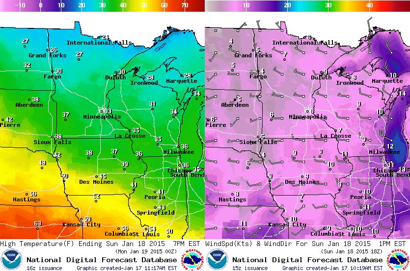
Sunday Weather Outlook
Lingering clouds and light snow showers will begin to fade as we head through the day Sunday. Sunnier skies across the southwestern part of the state will help to allow temperatures return to near the 40F mark once again. Sunday will actually be a pretty nice day for January! Just a bit sloppy... good boot weather.
Weather Outlook
Precipitation Outlook
According to NOAA's HPC, the 5 day precipitation forecast suggests several inches of liquid in the Pacific Northwest through the middle part of next week. Most of the moisture along the coast and lower elevations will be in the form of rain, but the higher elevations are set to pick up some decent snowfall!. The other area that could see decent precipitation amounts will be areas in the Northern New England States. However, temperatures don't look terribly cold, so significant snowfall is not expected.
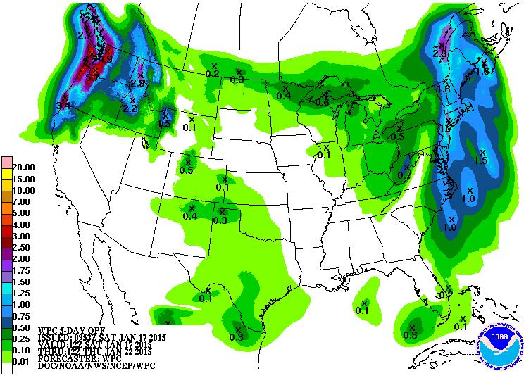
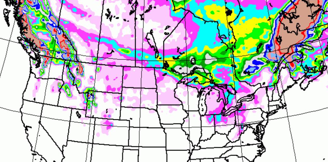
Snowfall Potential
A look at the snowfall potential through PM Tuesday below, there doesn't appear to be any significant snowfall events unfolding anytime soon across the Lower 48. Heavy snowfall potential will be mainly confined to the high elevation areas in the Cascade Range and the Northern Rockies!
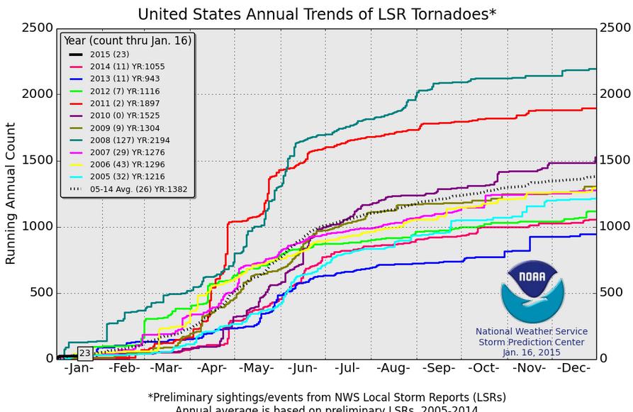
2015 Preliminary Tornado Count
According to NOAA's SPC, there have already been 23 PRELIMINARY tornado reports across the nation so far this year. It seems a bit odd, but the 2005-2014 average suggets that through January 16th, we typically see 26!
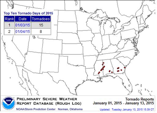
Top Tornado Days of 2015
According to NOAA's SPC, the top tornado days of 2015 occurred earlier this month on the 3rd and 4th across the Southeastern U.S.
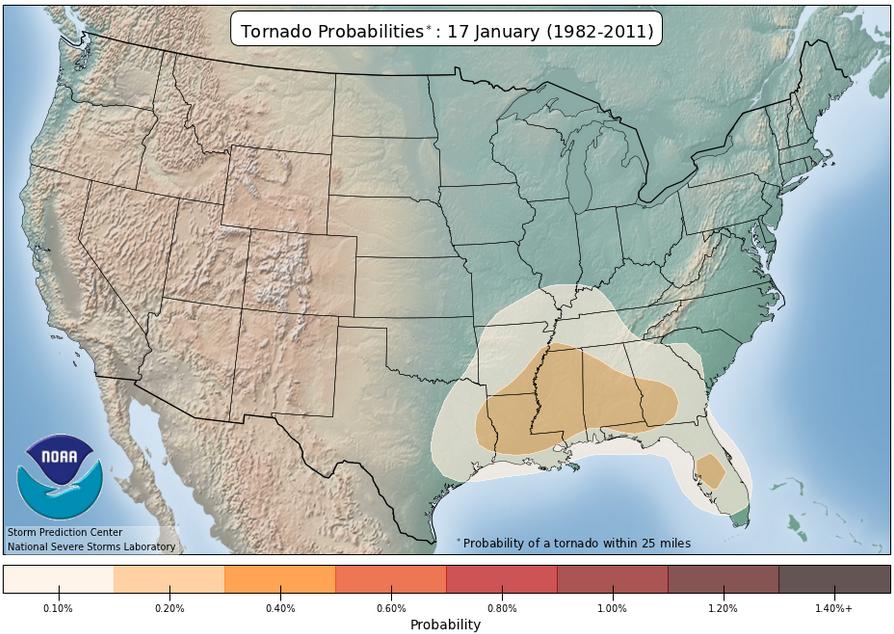
Tornado Climatology
Interesting to note that the tornadoes that have occurred already this year are in the area that typically sees the best chance of tornadoes at this time of the year.
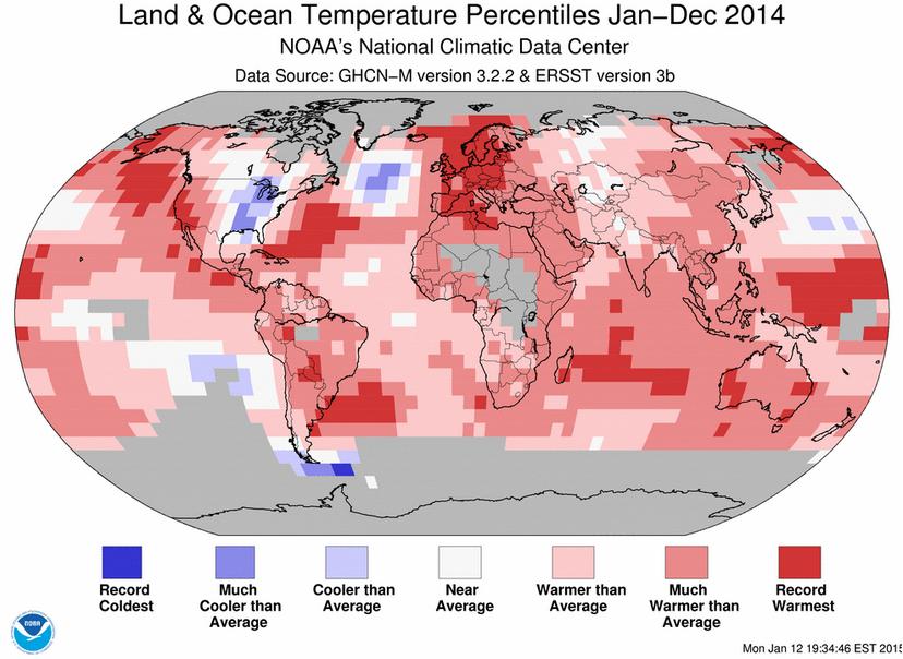
2014 Earth's Warmest Year on Record
According to NOAA, 2014 was officially the warmest year for the Globe. However, note one of the only cooler than average locations was that in the eastern U.S., while the western U.S. and California seemed to be well above average!
"2014 Earth's warmest year on record;
December 2014 record warm; Global oceans also record warm for 2014. The globally averaged temperature over land and ocean surfaces for 2014 was the highest among all years since record keeping began in 1880. The December combined global land and ocean average surface temperature was also the highest on record."
See more from NOAA's NCDC HERE:
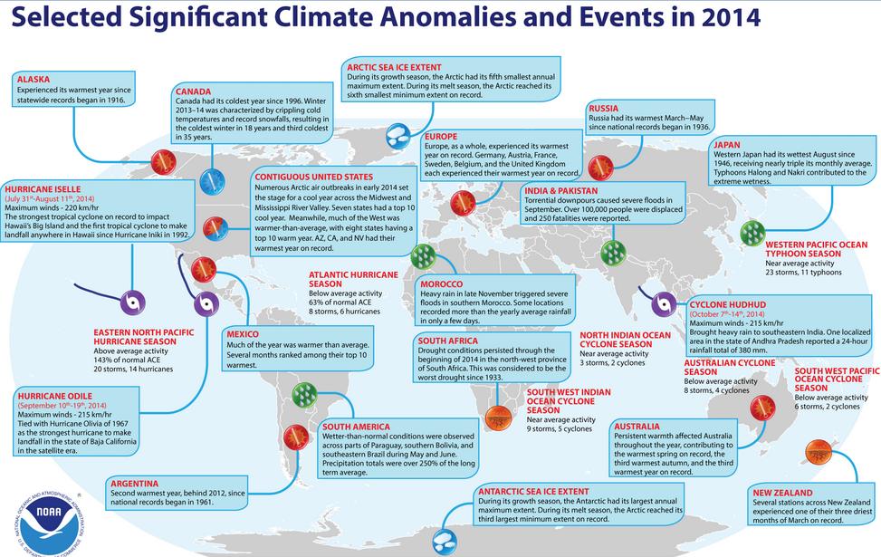
Significant Climate Anomalies and Events for 2014
HERE's and interesting look at some of the more impressive climate anomalies and events that took place during 2014: http://www.ncdc.noaa.gov/sotc/service/global/extremes/201413.gif
Thanks for checking in and have a great rest of your weekend! Don't forget to follow me on Twitter @TNelsonWX

No comments:
Post a Comment