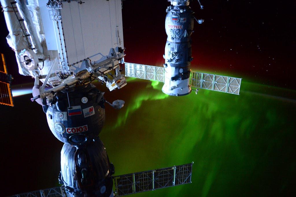
Aurora From the International Space Station!!
WOW! What a view!!
"On
March 9th, ISS commander Barry Wilmore looked out the window of the
space station and saw an amazing display of auroras. The green lights
were dancing around the Antarctic Circle in response to a high-speed
stream of solar wind buffeting Earth's magnetic field. It could happen
again on March 13-14 when another stream of solar wind is expected to
arrive. Polar sky watchers on Earth, and in Earth-orbit, should remain
alert for auroras."
(Image courtesy: @NASA_Astronauts “Riding the southern #Aurora” #AstroButch)
Spring Break
By Paul Douglas
By Paul Douglas
Some
years you go spring break, other years spring break comes to
you. Although shirtsleeve weather in March is still the exception, not
the norm. Let me get to the point: there's a good chance the mercury
will top 60F again Thursday, Friday and Sunday, before a minor tumble
next week - back down to average. A little perspective: low 60s
are common for late April.
Here's
something I've noticed over the years: people ask for a weather
forecast for their spring break destination: Florida, the Caribbean,
Mexico, Waterloo Iowa, whatever. But if the "spread" isn't big enough,
if they can't enjoy boasting rights with their friends, they seem
disappointed.
"Paul, I'm
in San Diego, where highs are only in the 60s. It's not much warmer
than Minnesota!" Maybe it's human nature, a need to justify all that
money you spent getting out of town.
Wednesday
will only be 15F warmer than average with a blue sky. Our vacation from
cold fronts lingers into Monday, when Canadian air invades our
weather-zen, dropping highs into the 40s to near 50 next week. My kind
of cold front.
This early puff of balmy air is invigorating but I'm increasingly concerned about moisture. Where are the big March storms?
==============
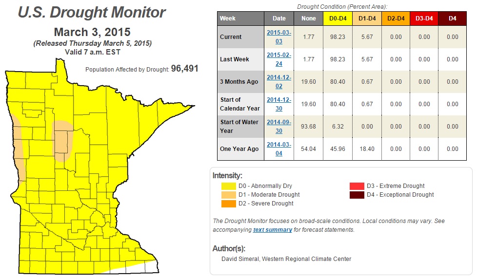
U.S. Drought Monitor: Minnesota
As
of Thursday, March 5th, nearly 98% of the state was considered to be
abnormally dry, while nearly 6% of the state was considered to be in a
MODERATE DROUGHT.
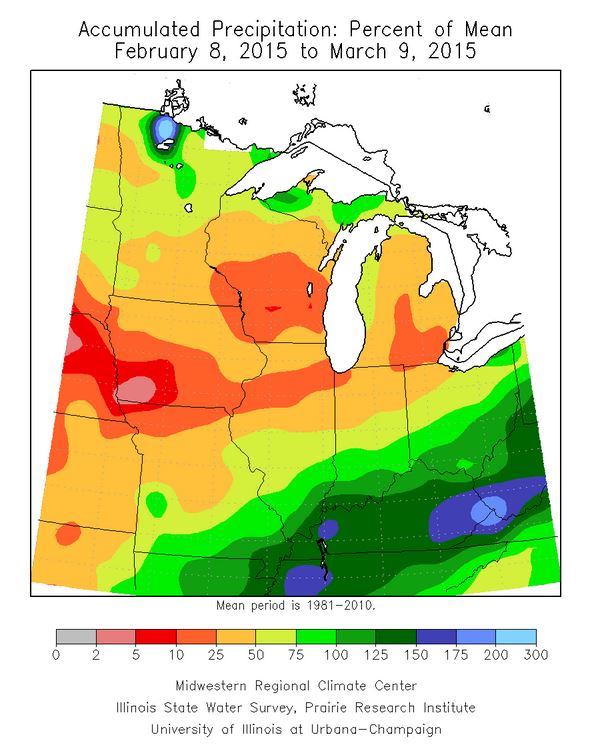
Below Normal Precipitation Past 30 Days
As
of Monday, the Twin Cities has seen only 27.2" of snow this season,
which is -18.2" below average. The Twin Cities is also -1.30" below
average precipitation for the year thus far. According to Midwestern
Regional Climate Center, parts of the Midwest have seen only 2% to 50%
of their 30 day average, while some folks in the Ohio Valley have seen
nearly 25% to 75% more than average!
========================
Twin Cities Extended Forecast
TUESDAY NIGHT: Mostly clear and quiet. Low: 32. Winds: WSW 10-15
WEDNESDAY: Partly cloud, a bit cooler. High: 55. Winds: SE 5
WEDNESDAY NIGHT: Mostly clear and mild. Low: 39. Winds: SSE 5.
THURSDAY: Fading sun, milder breeze. High: 64
FRIDAY: Mix of clouds and sun, still springy. Wake-up: 44. High: 61
SATURDAY: Blue sky, very pleasant. Wake-up: 36. High: 56.
SUNDAY: Average for late April, go outside. Wake-up: 40. High: 65.
MONDAY: Colder. Rain ends as a little snow. Wake-up: 48. High: 49.
TUESDAY: Plenty of sun, fresh breeze. Wake-up: 41. High: 53.
==============
This Day in Weather History
March 11th
March 11th
2009:
Cold conditions arrive, with a new record for the lowest maximum
temperature in St Cloud for this date. The high temperature in St Cloud
was only 4 degrees, which broke the previous record lowest maximum
temperature of 5 degrees that was set in 1948
1878: The ice was off Lake Minnetonka due to one of the warmest winters on record.
=============
Average High/Low for Minneapolis
March 11th
March 11th
Average High: 39F (Record: 66F set in 2012)
Average Low: 22F (Record: -27F set in 1948)
Average Low: 22F (Record: -27F set in 1948)
==============
Sunrise/Sunset Times for Minneapolis
March 11th
March 11th
Sunrise: 7:32am
Sunset: 7:14pm
Sunset: 7:14pm
=============
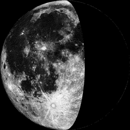
Moon Phase for March 11th at Midnight
1.5 Days Before Last Quarter
1.5 Days Before Last Quarter
==============
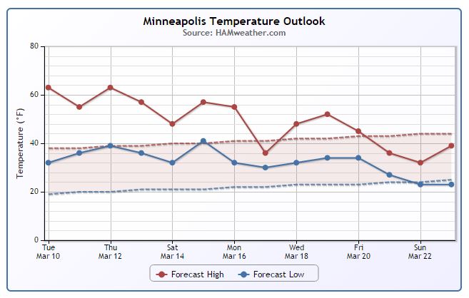
Minneapolis Temperature Trend
Spring
fever is in full swing this week with highs in the 50s and 60s. The
Twin Cities has hit it's first 50° and 60°+ since December 15th and
October 27th respectively. Mild weather continues with highs in the 60s
again Thursday; though, I would be surprised if some across southern MN
make it to 70° on Thursday! Extended forecasts suggests a slight
cool down (back to average/slightly below) by the Vernal Equinox (Friday,
March 20th).
====================
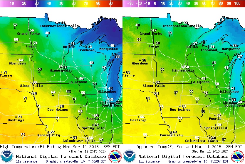
Midwest Temperature Outlook for Wednesday
After
a very mild Tuesday, temperatures on Wednesday will cool slightly.
However, highs in the 40s and 50s across the state is still well above
average! Light winds won't make it feel too much colder than the actualy
air temperature.
(Highs Wednesday: Left) (Feels Like Midday Wednesday: Right)
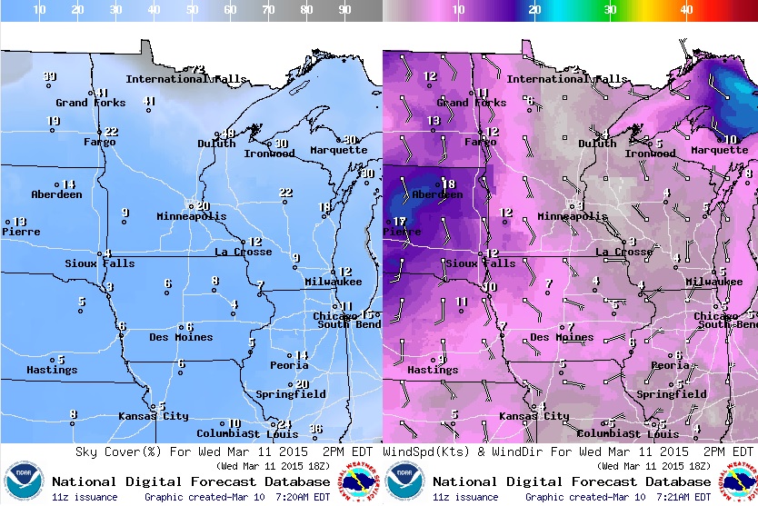
Midwest Weather Outlook for Wednesday
It
appears that we'll have more sunshine on Wednesday with more clouds
across the far north. Winds will also be light on Wednesday, but look to
pick up on Thursday.
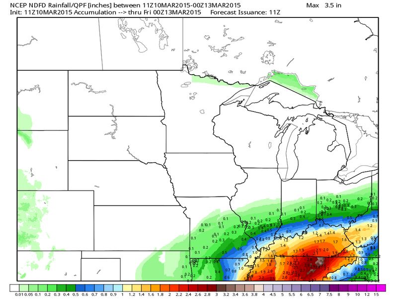
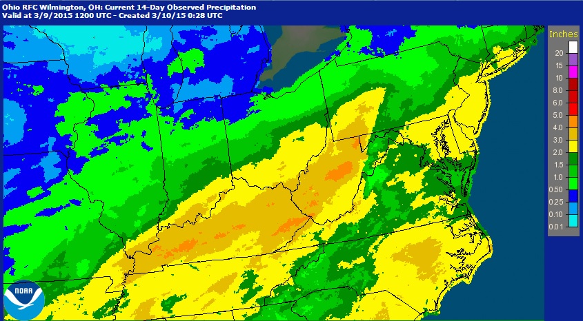
Midwest Precipitation Potential
Mostly
dry weather looks to continue through PM Thursday. The heaviest (up to
1" to 2"+) will sail through the Ohio Valley and create more flood
concerns. Precipitation amounts over the last 7 to 14 days throughout
parts of the Ohio Valley suggests nearly 2" to 4"+ has already fallen!
Precipitation Past 14 Days
According to NOAA radar estimates, nearly 2" to 4"+ precipitation has already fallen over the last 14 days
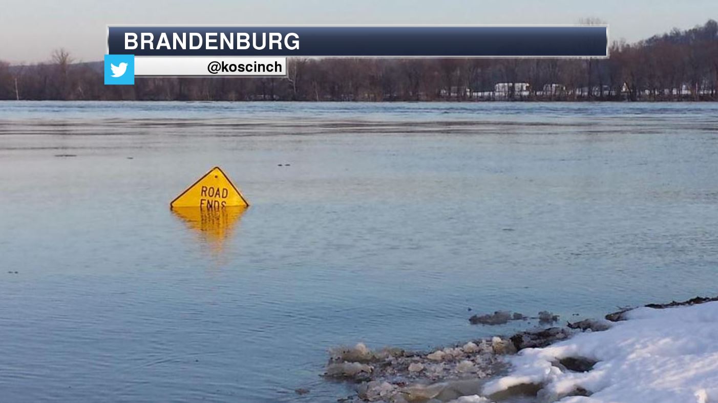
Flood Concerns Continue
Thanks to @koscinch for the picture below out of Brandenburg, KY, where the Ohio River is currently at MINOR FLOOD STAGE.
Cold February in the Midwest
February
ended up being -9.7° below average for Minneapolis thanks to a fairly
persistent northwesterly flow. According to IEM, several locations ended
up being in the top 5 coldest February's on record around the Great
Lakes/Ohio Valley. Eastern MN finished in the top 10 coldest February's
on record, while western MN finished in the top 20 coldest.
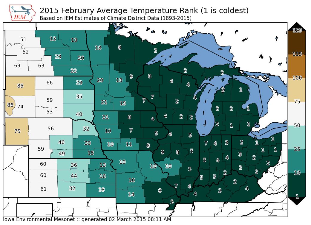
February Temperature Ranks
Here's
a quick look at how February temperatures turned out... interestingly,
the nation was nearly divided with record warm February's for
California, Washington, Arizona and Utah, while several states in the
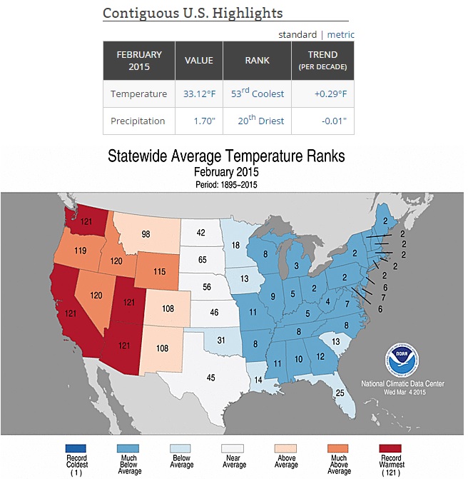
Northeast nearly had their coldest February's on record. Nationally,
February 2015 was the 53rd coldest on and the 20th driest on record...
"Cold winter, right? Um, not so much.
The USA's winter was actually about 2 degrees warmer than average overall, federal scientists from the National Oceanic and Atmospheric Administration announced Friday. It was the 19th-warmest winter since records began in 1895.
Though the East was chilly, it was more than offset by the phenomenally warm West, where Arizona, California, Nevada, Utah and Washington each had their warmest winter on record, NOAA said."
See more from USA Today HERE:
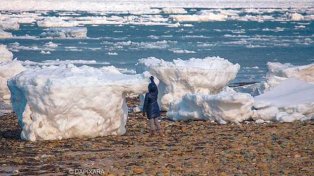
Giant Chunks Of Ice Wash Ashore On Cape Cod
"BOSTON (CBS) – The historic winter of 2015 has left giant chunks of ice on the Cape Cod National Seashore.
Cape Cod photographer Dapixara captured images of a person standing next to the massive pieces of ice that washed ashore in Wellfleet over the past few days. WBZ-TV Chief Meteorologist Eric Fisher says this could be a “once-in-a-generation” event due to the extraordinary amount of ice on the Massachusetts Bay."
See more from CBS Boston HERE:
(Image courtesy Dapixara Photography via CBS Boston)
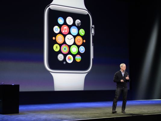
Apple Watch
Interested in the new Apple Watch? Here's an early review from USAToday.COM HERE:
"There are three collections: Apple Watch Sport, Apple Watch and the limited edition Apple Watch Edition, each with 38- and 42-mm sizing options and with numerous watchband selections.
Apple says the battery will last 18 hours after juicing it up through a snap-on proprietary magnetic charger, but until you put it through its paces you never know. There's also the all-important matter of comfort — this is something you're wearing on your wrist for long periods of time for goodness' sake, so you best not notice it until you want to actually view the time, glance at various notifications or complete a retail transaction through Apple Pay."
Thanks for checking in and have a great rest of your week! Don't forget to follow me on Twitter @TNelsonWX

No comments:
Post a Comment