48 F. average high on March 29.
43 F. high on March 29, 2014.
.19" rain fell at KMSP yesterday.
March 30, 1938: Springtime flooding hits Warroad and Grand Marais.
Silver Linings
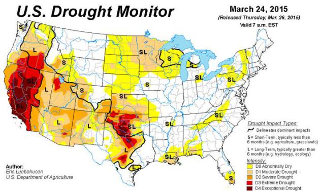
One small advantage of being in a drought with roughly half the average winter snowfall? A greatly diminished risk of river flooding in the coming weeks. A slightly cooler bias will probably delay the start of severe thunderstorm season, although a rumble of thunder may kick in late Wednesday as temperatures top 70F.
It's a little easier writing about the weather as we make the big, long turn into spring. The holidays and football tend to distract me from blistering fronts until January, when I develop a strong urge to hibernate. 3 months of hunker-down mode - 90 days of holding our breath; gloved fingers jammed in our ears, drowning out the echoes of a nagging arctic lullaby.
Winter is over, and even though we'll see more flurries the definition of a cold front will be 30s and 40s, not subzero.
With a rising sun angle the ground is warming faster than the upper atmosphere. Spring instability may kick off a late day shower, especially north of MSP. Reserve Tuesday and Wednesday to play outside as temperatures swoon into the 60s. If you don't develop spring fever by Wednesday check for a pulse.
Temperatures chill down by the weekend; a cool, dry bias the 2nd week of April.
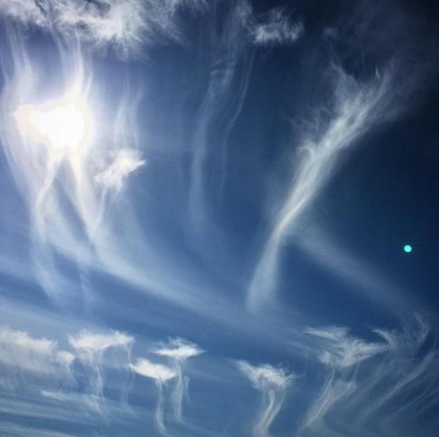
"Hey Paul. Look at these crazy clouds I saw yesterday. They look like jellyfish or wispy dandelions.
Have you ever seen clouds like these?" - Paul Lewis (Stillwater)
Paul, those were cirrus clouds, probably cirrus floccus. That's snow falling out of these wisps of ice crystals about 25,000 feet above the ground, prevailing jet stream winds aloft sweeping the falling ice crystals in a gentle arc before dry air evaporates the moisture.
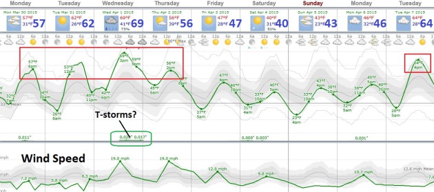
Spring Fling. The last few days have been chilly, but cold air retreats north into midweek, allowing temperatures to approach 60F today, surge into the 60s tomorrow and possibly top 70F on Wednesday before cooling off late week. A few T-showers may blossom Wednesday, although low-level moisture and dew points will be low. I still don't see any true soakings looking out 2 weeks. Graph: Weatherspark.
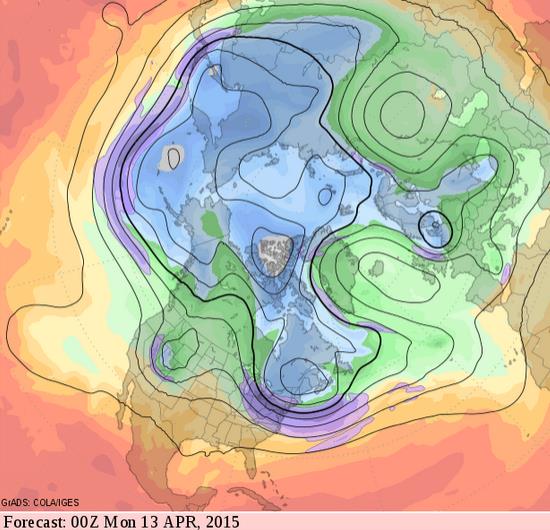
Gradual Mellowing Trend. Although spring will come very reluctantly to New England (Bostonians aren't surprised) long range guidance shows a weak ridge of warmth setting up over central Canada and the USA by April 12; implying warmer than average weather as we push into the second week of April. Source: GrADS:COLA/IGES.
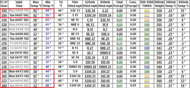
Warm Weather Spikes. Although more cool weather relapses are likely, the coldest air fades in the coming weeks. GFS data shows 60s around April 6-7, another surge of 60s and possible 70s by April 13-14.


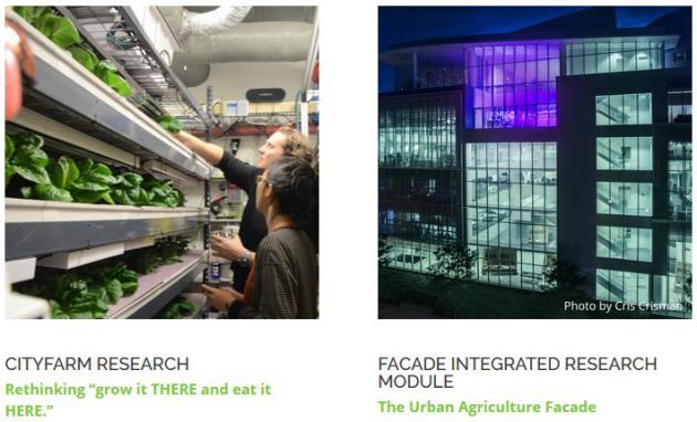
Why Vertical Farming Could Be On The Verge of a Revolution. Here's the intro to a story at Huffington Post: "Could the future of modern agriculture be found completely indoors? That’s the question on the mind of Caleb Harper, the research scientist behind the CityFARM project of MIT Media Lab’s City Science Initiative. On any given day on the fifth floor of the glass-walled Media Lab building, a team of 15 researchers led by Harper can be found operating the project's small indoor vertical farm. The CityFARM team includes mechanical engineers, biologists, architects and more, who manage pests, monitor water chemistry and grow produce such as tomatoes, leafy greens and herbs..."
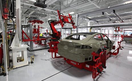
Falling Battery Prices Boost Outlook for Electric Vehicles. Innovation is sparking the price drops that will ultimately allow cleaner, renewable energy sources to go mainstream. It's happening faster than the skeptics and supporters thought it would. Here's an excerpt from RTCC.org: "The cost of batteries used in electric vehicles (EVs) has been falling fast and is almost certainly well below the estimates made by many analysts in the past decade. EVs may be able to compete directly with petrol-driven cars on cost a lot sooner than most people think. Policy-makers, transport and energy planners, and investors should take note..."
The
cost of batteries used in electric vehicles (EVs) has been falling fast
and is almost certainly well below the estimates made by many analysts
in the past decade.
EVs may be able to compete directly with petrol-driven cars on cost a lot sooner than most people think. Policy-makers, transport and energy planners, and investors should take note.
- See more at: http://www.rtcc.org/2015/03/23/falling-battery-prices-boost-outlook-for-electric-vehicles/#sthash.IccdftNL.dpuf
TODAY: Partly sunny, PM shower north. Winds: SW 10. High: 59
MONDAY NIGHT: Partly cloudy. Low: 40
TUESDAY: Plenty of sun, seriously springy. High: 63
WEDNESDAY: Feeling Feverish. Sun gives way to increasing clouds. Warm with a late-day T-storm? Wake-up: 49. High: 73
THURSDAY: More clouds than sun, cooler. Wake-up: 47. High: 57
FRIDAY: Partly sunny and brisk. Wake-up: 29. High: 48
SATURDAY: Mostly cloudy, jacket weather. Wake-up: 31. High: 51
SUNDAY: Cold rain develops. Wake-up: 38. High: 46
* photo above: Media Logic meteorologist Todd Nelson.
Climate Stories...

Warmer Nights Linked To Global Warming Trend. The warming signal is most obvious at night, during the winter months. Here's an excerpt of an Op-Ed from a Florida State meteorology professor at tallahassee.com: "...What is interesting is that there is growing evidence suggesting that the daytime increases in temperature are small compared to the warming of nighttime low temperatures. In other words, the nights do not cool as much. This suggests that the preponderance of the warming (where there is warming) will be significantly due to less cold nights..."

No comments:
Post a Comment