
Saving Time
By Paul Douglas
"Time is what we want most but... what we use worst" wrote William Penn of "Pennsylvania" fame.
I still have a problem living in the moment. Digital distractions, too many screens - always one more thing on my list. When this moment - what is right in front of me - is fleetingly precious. Transcendent. And gone. Most of us take the here-and-now for granted. Until we don't.
The start of DST, Daylight Saving Time, got me thinking about time-shifting. It's really a Daylight-DVR that kicked off during the First World War to save energy, not to give farmers more time in their fields.
So now we strap on our second-string (waterproof) shoes and hurtle into a fast-forward spring. Plan on 40s today, a streak of 50s this week, and if we lose most of the snow by Thursday (likely) 60F is not out of the question close to home. Hello April!
That sure was fast. 5 days ago wind chills dipped to -40F up north after the 14th coldest February on record, statewide. We keep flip-flopping from one extreme to the next as a drunken jet stream meanders overhead.
Speaking of time, Zall's Second Law states "How long a minute is, depends on which side of the bathroom door you're on." Yep.
=================
SATURDAY NIGHT: More clouds, a few snow flurries or snow showers late and mainly north. Low: 26. Winds: WNW 10mph
SUNDAY: Patchy clouds and a few flakes possible early. More sun later and mild! High: 43
SUNDAY NIGHT: Partly cloudy and quiet. Nothing rough. Low: 28. Winds: W 5-10.
MONDAY: More sun, milder breeze. HIgh: 51
TUESDAY: Blue sky, chirping birds. Nice. Wake-up: 29. High: 55
WEDNESDAY: Mix of clouds and sun. Most of the snow is gone. Wake-up: 32. High: 52
THURSDAY: Grilling weather. Touch of April. Wake-up: 37. High: 58
FRIDAY: Peeks of sun, slightly cooler. Wake-up: 42. High: 54
SATURDAY: Feverish. A few piles of dirty snow. Wake-up: 36. High: 57.
=============
This Day in Weather History
March 8th
2004: A vigorous Alberta Clipper brought a surprise intense snow burst across the Twin Cities from 9:30 am to Noon. 2.5 inches fell with most of it in an hour at the State Climatology Office on the University of Minnesota St. Paul Campus. Numerous crashes were reported across the metro area with I-94 closed at Highway 280 and also at White Bear Avenue. In a rare scene, television programming was interrupted to report on the snow situation. By early afternoon most of the snow had moved into Wisconsin and road conditions rapidly improved.
1892: Blizzard hit Minnesota with 70 mph winds at Easton. Duluth was hit especially hard with 60 mph winds causing large drifts. Persons were able to walk out of their second story windows.
==============
Average High/Low for Minneapolis
March 8th
Average High: 37F (Record: 69 set in 2000)
Average Low: 21F (Record: -8 set in 1877)
==============
Sunrise/Sunset Times for Minneapolis
March 8th
Sunrise: 7:38am
Sunset: 7:10pm
===============
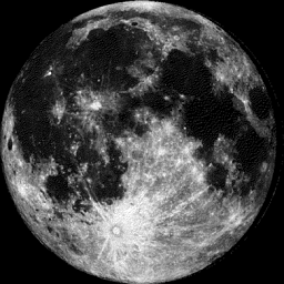
Moon Phase for March 8th at Midnight
2.5 Day After Full Moon
=================
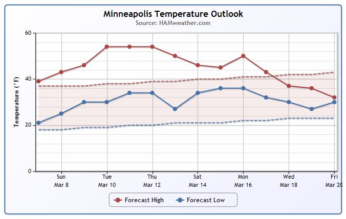
Minneapolis Temperature Trend
Spring fever will be in full swing through the week ahead with temperatures in the 40s and 50s, which is FINALLY above average! I wouldn't doubt to see a few 60s popping up across parts of southern Minnesota midweek. There may be a bit of a cool down by the 2nd half of the month, but let's enjoy the mild weather first!
====================
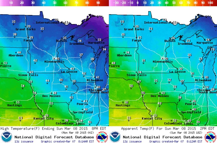
Sunday Weather Outlook
Ahh, don't the weather maps below look nice? It's amazing how warm 30s and 40s will feel after so many days of cold temps! Highs Sunday will rise into the 30s and 40s across the state with the mercury leveling off right around 40F in the Twin Cities! A little wind will make it feel cooler (20s and 30s) midday/early afternoon.
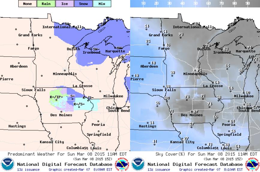
Sunday Weather Continued
A weak clipper will skirt across the northern part of the state Sunday with light snow chances. Minor snow accumulations will be possible from PM Saturday to Sunday. With that said, Sunday doesn't look quiet as sunny as Saturday did!
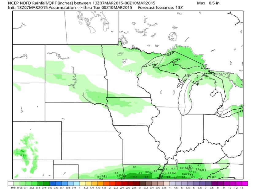
Midwest Precipitation Outlook
A fast moving clipper will move bring light precipitation potential to the Midwest PM Saturday/Sunday. Very little precipitation is expected through Monday across these areas. The best chance will be across parts of northern MN/U.P. of Michigan and through South Dakota/northern Iowa.
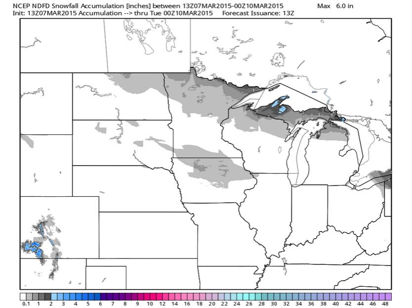
Midwest Snowfall Potential
Very little snow is expected across the Midwest through Monday. The best chance looks to be across northern MN/WI and the U.P. of Michigan. Some folks in the Arrowhead of MN could see a light coating up to 1" PM Saturday/Sunday as the system slides southeast.
National Weather Outlook
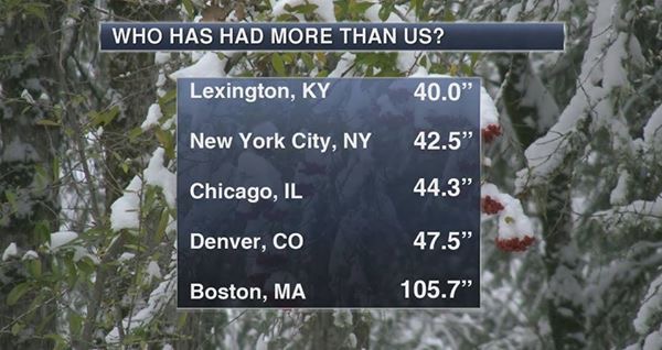
Last week's weather was pretty wild across the nation. Snow/Ice fell across parts of Texas, Kentucky and eventually to the Mid-Atlantic/Northeast. Up to 2ft. of snow fell in Kentucky, which is nearly as much snow as parts of Minnesota has seen ALL season!!
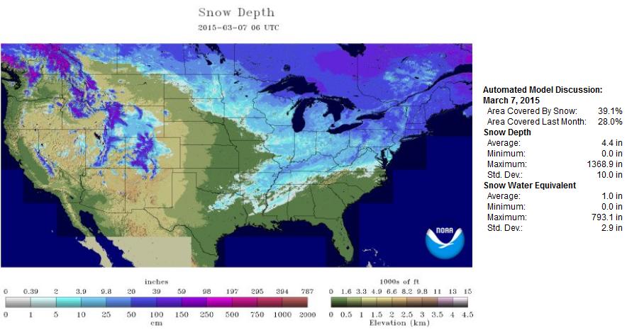
National Snow Depth 2015
As of March 7th, NOAA's NOHRSC suggested that nearly 40% of the nation was covered by snow.
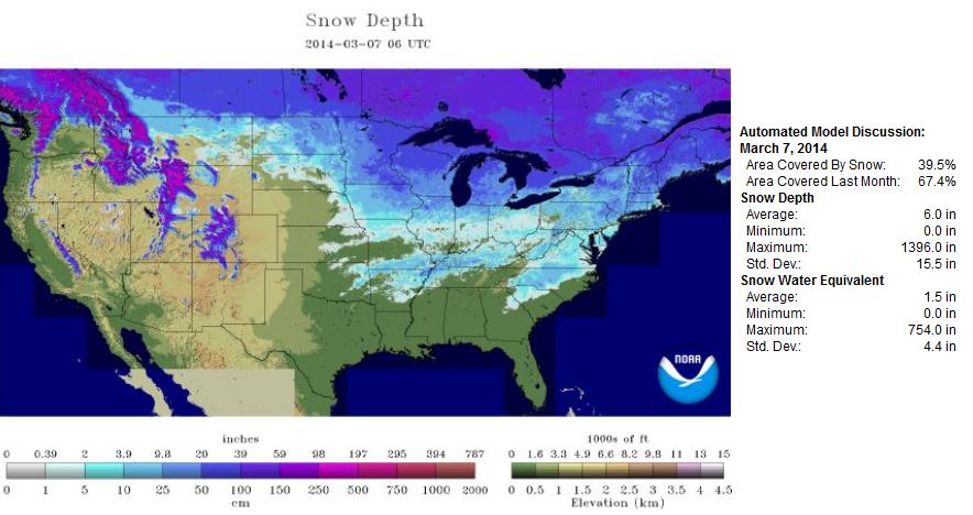
National Snow Depth 2014
Interestingly, NOAA's NOHRSC suggested that nearly 40% of the nation was covered by snow as of March 7th last year. However, if you look closely, Minnesota's snow pack was much heavier last year!
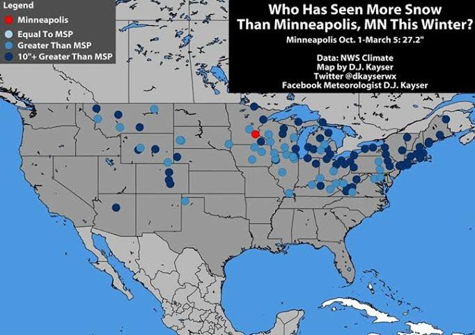
Who Has Seen More Snow Than Minneapolis This Year?
Thanks to my good friend and colleague, D.J. Kayser for the graphics below... Wonder who has seen more snow than MSP this year? All the blue dots indicate locations that have seen more than MSP, but the dark blue dots indicate locations that have seen 10"+ greater than MSP this season! Interestingly, Lexington, KY has seen 10"+ more snow than we have this season!
Melting Snow Pack
As of March 6th, the Twin Cities had only seen 27.2" of snow this season, which is 17" below normal! There have been a number of bare spots in my yard this year and with the upcoming warm weather, the snow here now will likely be gone by the middle/end of the week!

"Possibly low maximum in the north, a high minimum in the south"
Here is an interesting read from http://nsidc.org/arcticseaicenews/ about global sea ice...
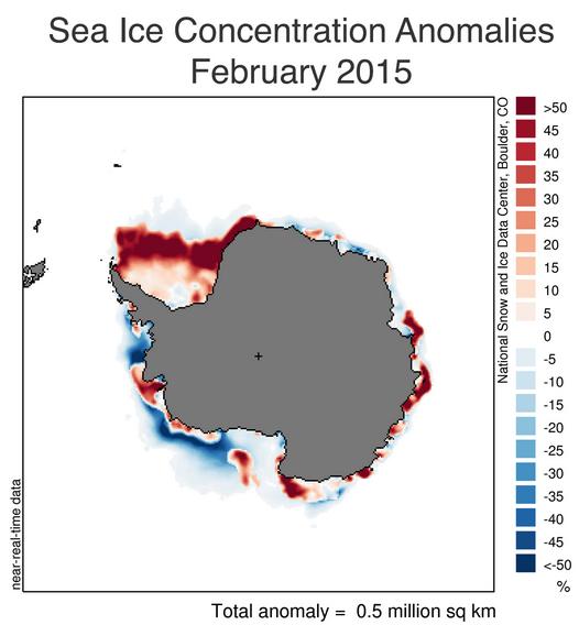
"Antarctic sea ice extent reached its annual minimum, dipping to 3.58 million square kilometers (1.38 million square miles) on February 20. This is the fourth highest summer minimum extent on record, trailing behind 2008 (3.75 million square kilometers or 1.44 million square miles, highest), 2013, and 2003. The 2014 Antarctic minimum ranked the fifth highest (3.54 million square kilometers or 1.36 million square miles). For the month as a whole, February 2015 has the sixth highest ice extent (3.8 million square kilometers or 1.46 million square miles). The sea ice extent trend for February for 1979 to 2015 shows an increase of 5.0% per decade. However, Antarctica’s sea ice extent is highly variable. As recently as 2011, Antarctic sea ice extent was at near-record low levels for the summer minimum."
"Arctic sea ice extent continues to track well below average, but it is still unclear whether March will see an increase in ice, or establish a record low maximum. Regionally, Arctic ice extent is especially low in the Sea of Okhotsk and the Bering Sea. In the Antarctic, sea ice shrank to the fourth highest minimum in the satellite record."
"Global sea ice trends"
"Claire Parkinson of NASA recently presented the global average (Arctic plus Antarctic) trend in sea ice extent for the period 1979 to 2013. Overall, global sea ice has declined, despite the positive trend in Antarctic extent. The annual average trend is -35,000 square kilometers (-13,500 square miles) per year, or about -1.5% per decade. The strong Arctic decline in September leads to the largest magnitude monthly trend for global sea ice in that month, at -68,000 square kilometers (-26,300 square miles) per year, or -2.6% per decade."
Thanks for checking in and have a great rest of your weekend! Don't forget to follow me on Twitter @TNelsonWX

No comments:
Post a Comment