63 F. high in the Twin Cities on Sunday.
74 F. average high on May 31.
86 F. high on May 31, 2014.
May 31, 1934:
Extreme heat in Minnesota with 107 in St. Paul and 106 in Minneapolis.
Rush City reached 110. There were numerous cases of heat ailments among
persons and livestock.
May 31, 1932: Heat wave with 108 at Campbell, Fairmont, Faribault, and New Ulm.
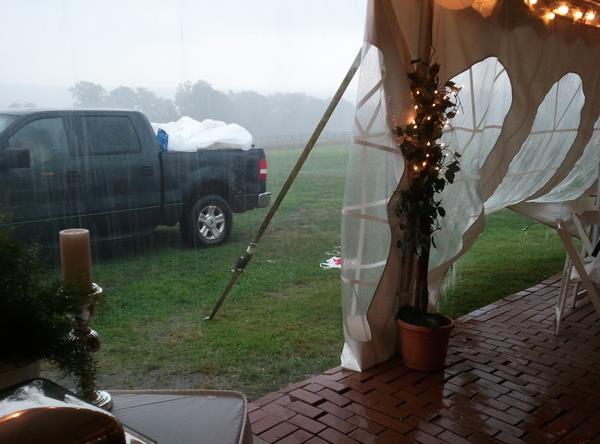
Rent the Tent!Welcome
to the wettest, most severe month of the year, on average. June 2014
was the wettest month ever recorded, statewide. The trend has been for
monsoon-like Junes since about 2010. Place your bets for 2015, but I
suspect it won't be as soggy as recent Junes.
Every year I plead
with June brides planning outdoor weddings. "Rent the tent!" I implore.
If you don't you make yourself a target. Mother Nature just can't
resist. June rains are heaviest late at night; T-storms flaring along
warm frontal boundaries. The best odds of dry weather: midday &
early afternoon. Nature never moves in a straight line but by mid and
late June we should be sweating through the 80s and a few 90s.
Today
is the start of meteorological summer, what is historically the 90
warmest days of the year.
And I'm still betting on a hotter summer than
recent years, thanks to, in part, a strengthening El Nino; the same
phenomenon that spiked rains over Texas, where 1 to 2 FEET of rain fell
in May.
T-storms move in
on Wednesday as temperatures mellow. Highs brush 80F by late week, warm enough for a dip in the lake but not oppressive. Not yet.
We dry out late week;
Saturday looks like the sunnier, nicer day.
* photo credit:
Joel Bischoff.
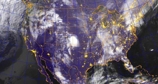
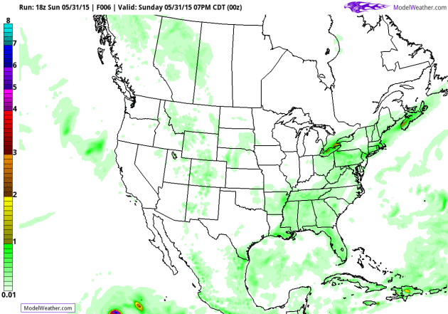
Wildest Weather Staying South and East.
Serious flash flooding was reported from persistent thunderstorms in
the northeast Sunday, and more heavy rain is brewing this week. Last
night's IR satellite image showed a cluster of strong to severe storms
pushing into Kansas, and as warmer air pushes northward we can expect a
few midweek thunderstorms across the Upper Midwest. Source:
Navy's NEXSAT.
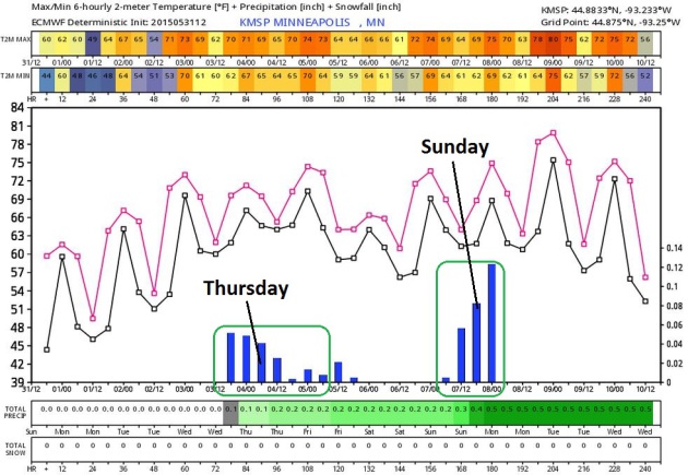
Wettest Days: Thursday and Sunday.
ECMWF guidance shows temperatures warming into the 70s later this week;
we may have to wait until a week from today to hit 80F, although GFS
guidance is a few degrees warmer. Showers and T-storms are likely
Thursday, tapering Friday, with another round of heavy storms Sunday.
Source: WeatherBell.
Greatest Flood Potential East Coast.
GFS guidance into next weekend prints out some 4-6"+ amounts from the
Carolinas and Virginias right up the I-95 corridor into Boston. Some
1-2" amounts are redicted for far northern Minnesota, maybe 2-4" across
western Iowa. Source: NOAA and AerisWeather.
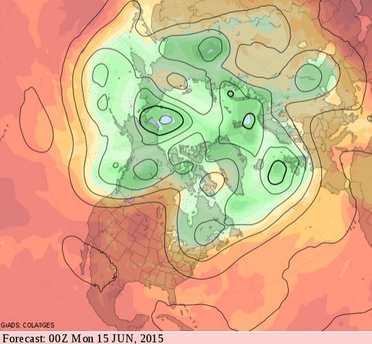
Building Heat.
GFS 500 mb guidance valid the evening of June 14 shows a broad ridge of
high pressure building over the central portion of the USA and Canada. I
want to see a few more model runs, but the chance of real heat (a
streak of 80s and 90s) seems to be increasing for 2-3 weeks from now. A
week before the summer solstice? That sounds about right: Source:
GrADS:COLA/IGES.
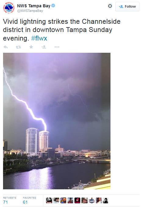
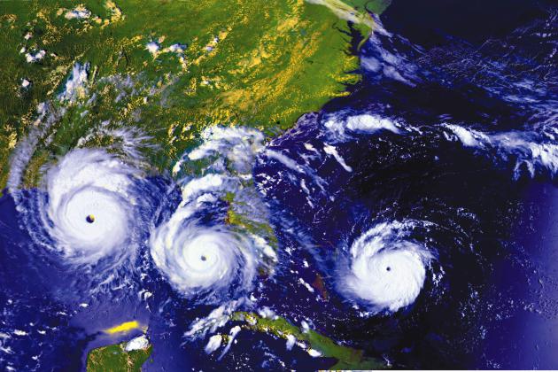
Southwest Florida Girds for Hurricane Season.
Will the "hurricane drought" come to an end in 2015? There's no way of
knowing, of course, but at some point the law of averages catches up
with you. Here's an excerpt from
USA TODAY: "...
Meteorologists
are calling for a relatively quiet hurricane season this year; experts
at Colorado State University are predicting seven named storms and three
hurricanes, with one of those becoming a major (Category 3 or higher).
But Feltgen and others are quick to warn: "It's only slow, quiet or
boring if you don't get hit. If you get hit it's anything but that. Some
of the worst hurricanes to hit the United Sates were during so-called
'slow season.' The classic case is Hurricane Andrew (in 1992). It was
the first storm of the year and it was a Category 5 right off the bat..." (1992 Hurricane Andrew sequence courtesy of NASA).
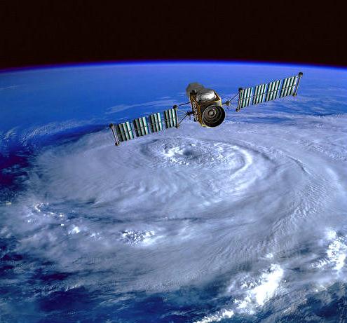
Hurricane Season 2015: Better Track Forecast Since Katrina, But Intensity a Puzzle.
What keeps hurricane forecasters up at night? A Category 1 hurricane
approaching a heavily populated area - people deciding to stay put and
ride out the storm ("it's only a cat 1!") only to have the storm
intensify rapidly before reaching land, putting millions at risk. Here's
an excerpt of a story at New Orlean's
NOLA.com: "...
But as the 2015 hurricane season begins Monday, experts warn that efforts to forecast the intensity of hurricanes are
still lagging behind, especially when a storm intensifies by more than
one category in a few hours -- a process called rapid intensification.
"On tracks, we're definitely 20 to 25 percent better than we were in the
Katrina timeframe," said Frank Marks, director of NOAA's Hurricane Research Division. "On intensity, we've moved the bar from no change in our forecasts to some change..."
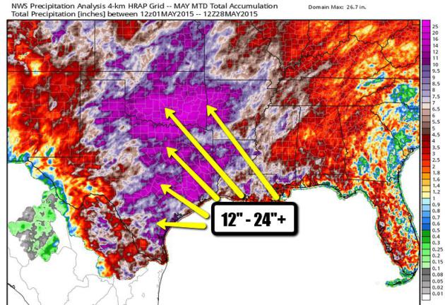
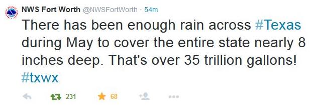
May Rainfall Amounts.
1 to 2 FEET of rain has soaked much of Texas and Oklahoma. I'm still
pretty blown away by not only the amounts but the size of the area
impacted. Flash floods usually affect a few counties, not an entire
state! May is the wettest on record, statewide, for Oklahoma and Texas.
Graphic: WeatherBell.
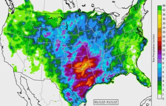
May Rainfall Timelapse. The Dodge City, Kansas office of the National Weather Service has a
YouTube animation that shows the ridiculous amounts of rain that fell over the southern Plains states. More than ever - when it rains it pours.
The Next Page: Tour Guide Keeps The Memories of the Johnstown Flood Alive. Here's a snippet of a poignant article at
The Pittsburgh Post-Gazette: "...
Few
people in town believed the dam really collapsed. It was known to have
been poorly constructed, and for almost a decade, every time there was a
hard rain someone would proclaim that the dam was about to burst. Mr.
Cakser says, “There was the ‘boy who cried wolf’ situation. Nobody
believed that the dam was going to break. When the messages got through
to Johnstown, the telegraph office staff actually laughed at it. It took
nearly an hour for the water to get to Johnstown and then 40 to 45
minutes of the water still coming at you.” It took that long for the
man-made lake to empty its contents into the valley..."
Photo credit above:
Robin Rombach/Post-Gazette. "The graves of unidentified flood victims at Grandview Cemetery in Johnstown."
Why Aren't The Aliens Here Already?
It's called Fermi's Paradox. If the universe is teaming with other
civilizations, many more advanced than our own, why aren't they here?
Unless they are, and they all moved to Hollywood. That's my working
theory. Here's an excerpt from
NPR: "...
For
today, however, let's just consider the one answer that really matters
for us, the existential one that is very, very freaky indeed: The aliens
aren't here because they don't exist. We are the only sentient,
technological species that exists in the entire galaxy. It's hard to
overstate how profound this conclusion would be. The consequences cut
both ways. On the one hand, it's possible that no other species has ever
reached our state of development. Our galaxy with its 300 billion stars
— meaning 300 billion chances for self-consciousness — has never
awakened anywhere else..."
Google Wants To Turn Your Clothes Into a Computer. I can't wait for "smart underwear". The very definition of progress. Here's an excerpt from
The New York Times: "
If
you thought it was only a matter of time before Google tried to turn
your pants into a computer, well, guess what, you were right. On Friday,
the second day of its annual developer conference, Google I/O,
one of the search giant’s semi-secretive research divisions announced a
project that aims to make conductive fabrics that can be weaved into
everyday clothes..."
Will Your Job Be Done By A Machine? NPR
has another interesting article that made me think - which really hurts
my brain, come to think of it, something robots won't have to worry
about. Here's a clip: "...
What job is hardest for a robot to do?
Mental health and substance abuse social workers (found under community
and social services). This job has a 0.3 percent chance of being
automated. That's because it's ranked high in cleverness, negotiation,
and helping others. The job most likely to be done by a robot?
Telemarketers. No surprise; it's already happening...."
I Fooled Millions Into Thinking Chocolate Helps Weight Loss. Here's How. Don't believe everything you read on the Internet - or the mainstream media for that matter. Here's a clip from
io9.com: "...
Other
than those fibs, the study was 100 percent authentic. My colleagues and
I recruited actual human subjects in Germany. We ran an actual clinical
trial, with subjects randomly assigned to different diet regimes. And
the statistically significant benefits of chocolate that we reported are
based on the actual data. It was, in fact, a fairly typical study for
the field of diet research. Which is to say: It was terrible science.
The results are meaningless, and the health claims that the media
blasted out to millions of people around the world are utterly unfounded..."
Kid President's 20 Things We Should Say More Often.
This kid has my vote. I have a sudden urge to dance, while clutching
corn dogs. Check out the video to see what I'm talking about. Here's a
link to a video that will brighten your day, courtesy of grammarly.com: "
If Kid President doesn’t bring a bit of happiness to your life, I don’t know what will!"
TODAY: More clouds than sun, milder. Winds: SE 10. High: 69
MONDAY NIGHT: Patchy clouds. Low: 53
TUESDAY: Some sun. T-Storms Red River Valley. High: 74
WEDNESDAY: More widespread T-storms. Dew point: 63. Wake-up: 58. High: 76
THURSDAY: Isolated storm, best chance southern MN. Wake-up: 63. High: 79
FRIDAY: Mix of clouds and sun, balmy. Wake-up: 62. High: near 80
SATURDAY: Fading sun, nicer day. Wake-up: 63. High: 81
SUNDAY: Few T-showers sprout. Wake-up: 64. HIgh: 76
Climate Stories....
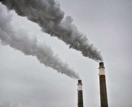
GOP Promises To Rein In Obama on EPA Rules, Global Warming.
ABC News has the latest - here's the intro: "
The
Obama administration says a new federal rule regulating small streams
and wetlands will protect the drinking water of more than 117 million
people in the country. Not so, insist Republicans. They say the rule is a
massive government overreach that could even subject puddles and
ditches to regulation. Sen. Shelley Moore Capito, R-W.Va., is promising to "rein in" the government through legislation or other means..."
Join The Tar Sands Resistance March. The march is on Saturday in St. Paul, ending at the Capital lawn for a rally.
Details here: "
Tar
sands oil can seem like a far-away issue in Minnesota (it's one of the
world's dirtiest fuels, mined from underneath Canadian boreal forests),
but we're connected to it in a big way. Most of the tar sands oil used
in the U.S. comes across northern Minnesota on pipelines operated by the
Enbridge company. Enbridge is looking to expand the flow of tar across
the border, and Minnesotans and others from around the region are
pushing back, concerned about the particularly high greenhouse gas
emissions of producing this fuel. Join them: tarsandsresistance.org..."
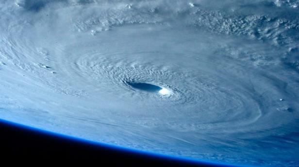
Super Typhoons To Increase In Strength With Climate Change. This applies to hurricanes in the northwest Pacific (called typhoons), based on research highlighted at
Stuff.co.nz: "...
A
study covering 850 typhoons in the region found the intensity of the
damaging storms has increased by about 10 per cent since the 1970s, said
Wei Mei, a climate scientist at the Scripps Institution of Oceanography
at the University of California, San Diego, and a co-author of the
study published in the journal Science Advances. Using 20 models and a
mid-range projection of carbon dioxide emissions, the researchers found
the peak intensity of storms such as super Typhoon Haiyan, which tore
through the Philippines in November 2013, will become even stronger and
more common..." (Image: NASA).


No comments:
Post a Comment