72 F. high in the Twin Cities Friday.
73 F. average high on May 29.
84 F. high on May 29, 2014.
.29" rain fell at St. Paul yesterday.
.54" rain fell yesterday at Twin Cities International Airport.
.61" rain reported at Crystal.
.63" rain at Redwood Falls Friday.
May 30, 1998:
Devastating line of storms hits east central Minnesota. 100 mph winds
in Scott and Dakota County. Over 500 homes damaged in Washington County.
15,000 trees lost in the Twin City metro area. 500,000 without power in
Minneapolis.
May 30, 1985: Tornado hits Lakefield. The Twin Cities report 67 mph winds.
Welcome WhiplashThe
fastest changes in weather - and the greatest extremes in temperature
and moisture can be found near the center of continents; well away from
the moderating influence of ocean water. Exhibit A: Minnesota.
I'm
continually amazed by how fast patterns can change at this lofty
latitude. A few weeks ago our drought situation seemed dire.
Today most of Minnesota is drought-free.
And the area of moderate drought has fallen from 50 to 24 percent of
the state - mainly northern and east central Minnesota, including much
of the metro. But farmers are breathing a lot easier, or will as soon as
they can get back into their muddy fields.
Feast or famine, flood
or drought - most days it feels like Mother Nature has her foot on the
gas - and we're all in the backseat, complaining of whiplash.
Today
will feel like something out of late September with cool sunshine and a
stiff north breeze. Maybe it'll blow the mosquitoes into Iowa. 80s
return the latter half of late next week with mostly garden-variety
thunderstorms.
No sign of a major severe storm outbreak close to home just
yet.
California's in a withering drought, Texas is overflowing with muddy water. Here we sit, green and quiet.
Thank God.
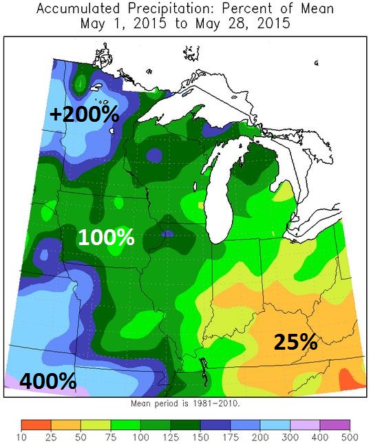
A Drought-Busting May. Much of the state is still too dry, but the trends are encouraging. Here's an excerpt of Mark Seeley's latest
WeatherTalk Newsletter: "...
The
most notable feature of the month was surplus rainfall. Most climate
stations reported above normal rainfall amounts, and in some cases twice
normal rainfall. The wettest part of the state was across the central
counties where 4 to 6 inch amounts were common. Many places reported
measurable rainfall on half the days of the month. Over 40 communities
reported new daily record rainfall amounts for selected dates during the
month..."
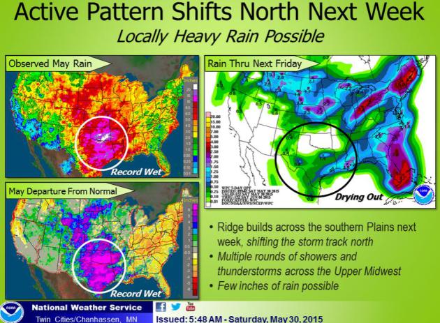
Graphic credit: "
Percentage of mean precipitation for May, to date". Courtesy:
Midwest Regional Climate Center.
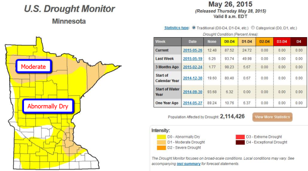
Minnesota's Drought is Fading Fast.
The same shift in the pattern bringing historic rains to Texas and
Oklahoma is also fueling more heavy rain for Minnesota, and the drought
that kicked off spring in the Upper Midwest is fizzling faster than you
can say "weather whiplash". In one week moderate drought went from
affecting nearly half of Minnesota to 24% of the state. Parts of central
and far southern Minnesota are now drought-free. At the rate we're
going much of the state may be in good shape with soil moisture and
lake/river levels within another 2-3 weeks. The latest U.S. Drought
Monitor for Minnesota is
here.
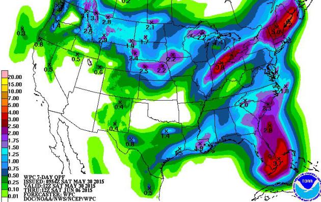
Weekend Break - More Storms Next Week.
The leading edge of 80s and a few 90s will push northward again next
week, setting the stage for more showers and T-storms by midweek; NOAA
guidance suggests some 2-3" amounts for portions of southern Minnesota
next week. Yes, it would be ironic if we went from drought to flood, a
minor league version of what happened in Texas and Oklahoma? I'm not
predicting that degree of whiplash, but we'll get a taste.
Comfortably Cool Weekend - Sticky Weather Returns Next Week.
European model guidance shows the best chance of showers and T-storms
next Wednesday and Thursday as dew points top 60F, meaning humid
conditions. I still believe European guidance is underestimating the
warmth: we should see a few days in the 80s next week. Source:
Weatherspark.
Crazy Extremes.
Check out the observed May rainfall and departure from normal. Much of
Minnesota has seen twice as much rain as normal so far in May, Parts of
Texas have seen 4-8 times more rain than typical. The Twin Cities office
of the National Weather Service agrees that some of the storms next
week firing up along a nearly stationary, west to east frontal zone, may
pack locally heavy rain.
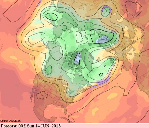
From Flood to Heat Wave?
Watch how quickly the central and southern Plains go from biblical
levels of moisture to sizzling heat in the coming weeks. GFS predicted
winds at 500 mb continue to hint at the formation of a sprawling
heat-pump high pressure ridge over the Plains by mid-June, which could
mean 90s, even a few 100-degree highs from Denver and Wichita to Dallas.
Source: GrADS:COLA/IGES.
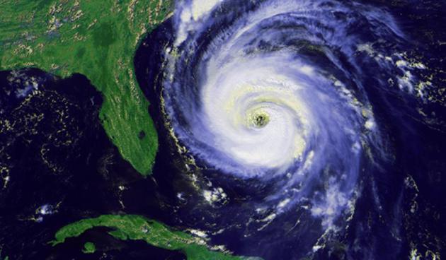
Florida Setting Amazing Hurricane Record.
At some point the hurricane drought will come to an end and we may tip
over into a much more active pattern. Here's an excerpt of a story at
wtsp.com: "
No
hurricane has hit Florida in nearly 10 years. It's a dry spell that has
kept us safe, but it also creates a huge, dangerous challenge for
emergency planners. This is the longest stretch without a hurricane
Florida has experienced since records started being kept in 1851. It's
one of the big things they'll be talking about at the free Tampa Bay Hurricane Expo on Saturday at MOSI in Tampa..." (Image credit: NOAA).
Which Hurricane Forecast Model Is The Best?
It's still ECMWF. I hope the GFS and HWRF can catch up and surpass what
the Europeans are capable of - I wouldn't bet against them over the
long term, but the USA is just not there yet. Here's an excerpt of a
story at
CNBC: "...
According
to most people in the industry—or just plain statistics—the European
model is the best, and has been for years. Almost any report will
describe it as the best. Technically, you want to look for the acronym
it goes by—ECMWF—which stands for the European Center for Medium-range
Weather Forecasting. A big factor in its dominance recently is due to a
2006 improvement in its model. The Europe model's advantage comes from
several sources:
Powerful supercomputers that can analyze larger amounts of data, taxes
paid by the member nations of the European Union to help keep funding
up, and charging money to other forecasters who want its data..."
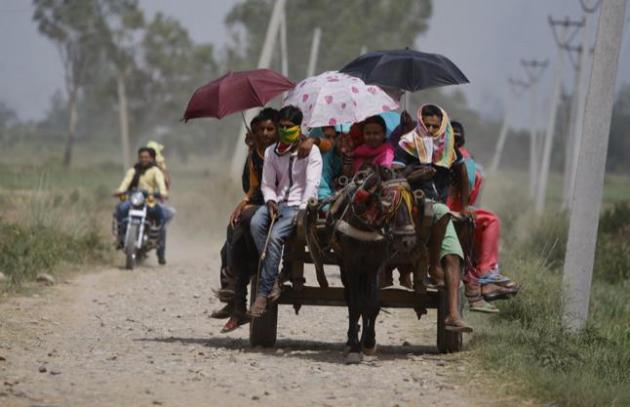
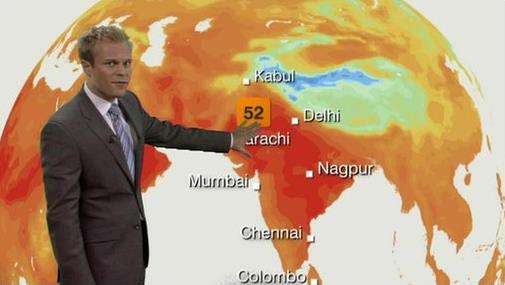
The Death Toll From India's Hellish Heat Wave Is Now More Than 1,800. TIME has more details on the historic heat wave now underway in India; here's an excerpt: "...
Forced
to work under the blazing sun, construction workers like Devi, along
with the homeless and the elderly, have been the hardest hit by the
heatwave that so far has led to over 1,800 deaths,
the vast majority of them concentrated in the southeastern Indian
states of Andhra Pradesh and Telangana. Together, those states account
for over 1,750 deaths. Deaths have also been reported in Delhi and other
states, including Gujarat and Odisha, where temperatures earlier this
week peaked at a sweltering 116.6°F (47°C)..."
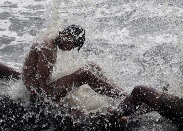
Photo credit above: "
An
Indian man enjoys high tide waves at the Arabian Sea coast in Mumbai,
India, Friday, May 29, 2015. Dizzying temperatures caused water
shortages in thousands of Indian villages and killed hundreds more
people over the past day, driving the death toll from a weeks long heat wave to more than 1,000, officials said Friday." (AP Photo/Rajanish Kakade)
India Heat Wave Tests Water Supply. A preview of coming attractions? Here's a clip from a story at
Huffington Post: "...
Thousands
of water tankers were delivering supplies to more than 4,000 villages
and hamlets facing acute water shortages in the central state of
Maharashtra, state officials told the Press Trust of India news agency.
People across India were plunging into rivers, staying in the shade and
drinking lots of water to try to beat the heat. Scorched crops and dying
wildlife were reported, with some animals succumbing to thirst..."
Photo credit above: "
Indian
devotees hold umbrellas to protect themselves from the sun during the
annual festival of Sufi saint Saiwali Pir Baba at Sangral, near the
India-Pakistan international border, about 38 kilometers south of Jammu,
India, Thursday, May 28,2015. Eating onions, lying in the shade and
splashing into rivers, Indians were doing whatever they could Thursday
to stay cool during a brutal heat wave that has killed more than 1,000
in the past month." (AP Photo/Channi Anand)
India Heat Wave May Be 5th Deadliest on Record. Dr. Jeff Masters has some eye-opening details at
Weather Underground: "
The death toll from India's horrid May heat wave has risen to 1,826,
making this year's heat wave the second deadliest in India's recorded
history--and the fifth deadliest in world history. According to
statistics from EM-DAT,
the International Disaster Database, India's only deadlier heat wave
was in 1998, when 2,541 died. With over 400 deaths recorded in just the
past day and the heat expected to continue over India for another week,
the 1998 death toll could well be exceeded in this year's heat wave..."
The 10 Deadliest Heat Waves in World History1) Europe, 2003: 71,310
2) Russia, 2010: 55,736
3) Europe, 2006: 3,418
4) India, 1998: 2,541
5) India, 2015: 1,826+
Image credit above: BBC News.
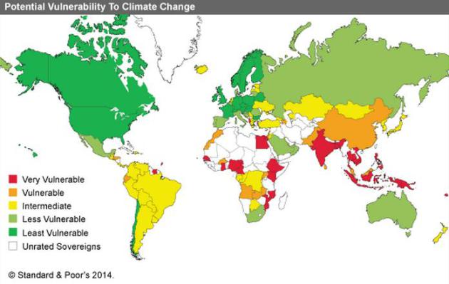
A Climate Link to Indian Heat. Here's an excerpt of a story at
The Times of India that made me do a double-take: "
Climate
records show that human-induced global warming had turned 2014 into the
hottest year on record. Eight out of the 10 warmest years in India were
during the recent past decade (2001-2010), making it the warmest decade
on record with a decadal mean temperature anomaly of 0.49 C. CSE
climate researchers say more heat waves were expected as, globally,
temperatures had risen by an avereage 0.8 degrees in the past 100 years.
Night-time temperatures are rising too, with Ahmedabad and Delhi
recently reporting 39 and 36 degrees centigrade. "The number of heat
wave days may go up from about 5 to between 30 and 40 every year" they
add..." (Map credit: Standard & Poor's, 2014).
Hopes Rise For a Strong El Nino To Ease California Drought.
The same warm phase of the Pacific that's spiking rainfall amounts for
Texas and Oklahoma may bring more much-needed rain to California later
this year; here's an excerpt of a story at
The Los Angeles Times: "...
El
Niños have been responsible for two of California's wettest and most
destructive rainy seasons: the winters of 1982-83 and 1997-98. Now,
experts say, a potentially powerful El Niño this winter could be the
beginning of the end of the drought. This month's weather suggests how
El Niño's building strength is already affecting the United States. It's
giving weather scientists reason to be cautiously optimistic that it
has the stamina to see it through California's rainy season, which
typically begins in October and ends in April..." (File image above).
California's Drought Is So Bad, Thieves Are Now Stealing Water. The Daily Beast has the details; here's a link: "...
Forget
gold or cash, credit cards or gas: The hot new commodity in the land of
drought is H20. In drought-plagued California, thieves are getting
mighty thirsty. At least one managed to make off with a 500-gallon water
tanker. The wide load just up and vanished from a highway offramp. It
was early morning last Thursday when the Marina landscaping tanker truck
was idling on a median by a tunnel in Oakland, according to police
reports. Then some clever perp jacked it—and rode off with its tapped
cargo..."
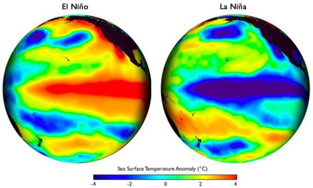
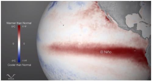
El Nino Can Raise Sea Levels Along U.S. Coast. As water warms it expands, which causes water levels to rise. Here's an excerpt of a good explainer from
Climate Central: "
The
El Niño event underway in the Pacific Ocean is impacting temperature
and weather patterns around the world. But its effects aren’t confined
to the atmosphere: A new study has found that the cyclical climate
phenomenon can ratchet up sea levels off the West Coast by almost 8
inches over just a few seasons. The findings have important implications
in terms of planning for sea level rise, as ever-growing coastal
communities might have to plan for even higher ocean levels in a warmer
future..."
Image credit above: "
Sea surface temperatures in the eastern tropical Pacific Ocean during the very strong 1997 El Nino event." Graphic courtesy of NOAA.
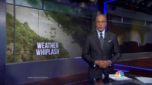
"Weather Whiplash" Promises To Bring More Dangerous Extremes. Where have you heard that before? Here's a link to a segment on Thursday night's edition of the
NBC Nightly News: "
Scientists
say climate change is exacerbating the wild weather swings amid a year
of historic floods, fires, tornadoes, snow and ice across the U.S."
*
35 Trillion Gallons.
That's how much water has fallen on Texas since the beginning of May,
enough to cover the entire Lone Star State to a depth of 8". More
remarkable statistics are
here, courtesy of NBC News.
A Silver Lining To Texas's Biblical Floods?
No, Mother Nature is not on a dimmer switch. Moisture is either on or
off. Either Exceptional Drought, or Monsoon-like Flood. This was one
heckuva way to end a prolonged drought. Here's an excerpt of a story at
WIRED: "..
.The
devastation caused by these floods is heart-wrenching. But you could
consider Texas’ weather whiplash to be a good thing: These dousing
storms, which seem more and more like the consequence of a strengthening
El Niño, have
brought an end to a four-year water shortage. Just how much of a silver
lining these floods are creating, though, depends on the particular
geography of Texas’ different regions—it is a gigantic place, y’all. And
the land’s composition also plays a crucial role in just how bad the
flooding has gotten..."
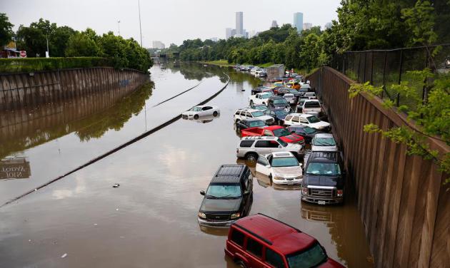
Photo credit above: "
Motorists
are stranded along I-45 along North Main in Houston after storms
flooded the area, Tuesday, May 26, 2015. Overnight heavy rains caused
flooding closing some portions of major highways in the Houston area."
Cody Duty/Houston Chronicle/AP.
Climate Change, A Factor in Texas Floods, Largely Ignored. Here's a clip from a story at
The Texas Tribune: "...
Extreme weather events,
and more of them, are among the most agreed-upon effects of global
warming in all the scientific literature on the subject, said
Nielsen-Gammon, who is also a professor at Texas A&M University.
Part of the explanation is that ocean temperatures are rising, bringing
more moist air into the state that can create storm systems. In the past
century, precipitation in Texas is up 7 to 10 percent, and the
frequency of two-day heavy rainfall spells has nearly doubled..."
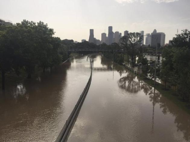
Photo credit above: "
A
photo provided by the Harris County Flood Control District shows flood
waters covering Memorial Drive along Buffalo Bayou in Houston, May 26,
2015. The heavy rains have killed at least eight people in Texas and
Oklahoma, including two in Houston where flooding turned streets into
rivers." (Harris County Flood Control District via The New York Times).
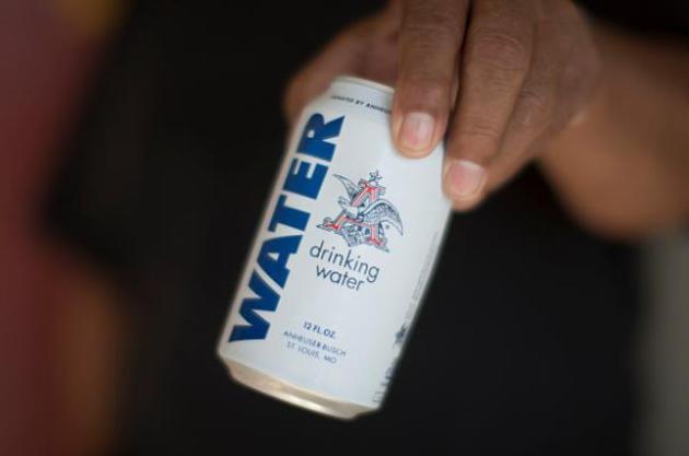
Anheuser-Busch Stopped Making Beer To Can Water For Flood Victims. Kudos to Anheuser Busch for doing this, more than just a PR gesture. U.S. News has the
story: "...
Cheers
to Anheuser-Busch. The big-time brewer has suspended beer-making in its
Georgia brewery and is instead canning water for flood victims in Texas
and Oklahoma, according to NBC News.
Production at the Cartersville, Georgia, brewery — one of 12
Anheuser-Busch runs in the United States — was halted late Wednesday to
instead produce cans of water for the American Red Cross..."
Photo credit above: "
In total, 51,744 cans will be heading to flood victims in Texas and Oklahoma."
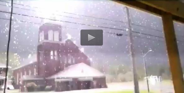
Don't Try This At Home: Grand Isle Student Captures Lightning Strike on Church Steeple. Yes, this is a little too close for comfort. Check out the video and story at
Bangor Daily News: "...
About
6 p.m., as a line of strong thunderstorms was passing through the St.
John Valley, Bouley stood on his Grand Isle home’s front porch and aimed
his iPhone camera toward the St. Gerard Catholic Church steeple.
Seconds later, a bright streak of lightning can be seen hitting the
building, producing a fireball and accompanied by a massive crack of
thunder. “As soon as I pointed the camera to the ground and back up, it
happened,” Bouley said..."
"Awair" Helps You Monitor The Air Quality In Your Home. I found this interesting, especially for people who have respiratory problems or severe allergies. Here's a snippet from
Gizmag: "...
You
can set Awair up to track the air quality with different purposes in
mind, whether it's focused on reducing allergies or increasing
productivity. It will then give you recommendations on how to change
your behaviors to improve the air quality for that particular purpose.
Awair takes a number of readings, including the temperature, humidity,
and the levels of dust, CO2, and VOCs (Volatile Organic Compounds) in
the air. These are then combined to give an Awair Score, letting you
know the overall quality of the air you're breathing in your own home.."
This Tiny Car Can Change Shape and Drive Sideways. This might come in handy on Highway 100. Here's a link to a video and story excerpt at
Mashable: "
Why do we call the Mercedes Benz Smart Car
smart — when it's really just small? A truly smart car might be able to
drive sideways, like the equally tiny, shape shifting EO Smart
Connecting Car 2. A research project
from the German Research Center for Artificial Intelligence, the EO 2
is designed for crowded cities where rush hours are nightmares and
parking in nearly non-existent..."
TODAY: Hints of September. Lot's of sunshine, windy and cool. Winds: N 10-15. High: 63
SATURDAY NIGHT: Mostly clear - light jacket-worthy late. Low: 45
SUNDAY: Plenty of sun, less wind. Winds: SE 10. High: 67
MONDAY: Some sun, trending milder. Wake-up: 49. High: 71
TUESDAY: Sticky sun, isolated T-storm. Wake-up: 55. High: 74
WEDNESDAY: T-storms, then steamy sun. Dew point: 62. Wake-up: 63. High: 82
THURSDAY: Unsettled, more T-storms likely. Wake-up: 67. High: 83
FRIDAY: Warm sun, a bit drier. DP: 64. Wake-up: 65. High: 85
Climate Stories....
Bill Nye Under Attack For Linking Texas Floods to Climate Change.
EcoWatch has the story - here's a snippet: "...
And while no one single weather event can be linked to climate change,
recognizing that the event is part of a larger trend of extreme
weather, which is caused by climate change, should have been no big deal
to do. Scientists have been saying for years that as carbon emissions increase, so will extreme downpours. “When you have a warmer atmosphere, then you have the capability to hold more water vapor,” Brenda Ekwurzel of the Union of Concerned Scientists told Alternet. “When storms organize, there’s much more water you can wring out of the atmosphere compared to the past...” (File Photo credit: Brian Ach, AP Images for Sylvan Learning).
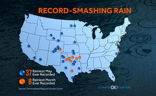
Flooding From Extreme Downpours May Be More Common With Climate Change. Here's a snippet of a story at
Tucson News Now: "...
The
below graphic shows where new records were set for May or monthly
rainfall. Phoenix even made the list with 1.17" of rain, much of that
coming in two spring storms passing over the city on May 4 and May 15.
No flooding occurred in Phoenix but it stacks up as the wettest May on
record because May is usually one of the driest months of the year for
the city. June is on-average the only month drier than May..." (Graphic credit: Climate Central).
Flawed Forecast From Ducey And Climate Change Skeptics. Here's an excerpt of an Op-Ed from
azcentral.com in Arizona: "...
According
to a University of Arizona and Stanford University study, more than 70
percent of Arizona residents believe the government should limit
greenhouse gases. The conclusions of the scientists cited above are
based on methodical study of the natural world, not on whether they
belong to the Republican Party or are Democrats.We live a state where
climate change will have a huge impact on our lives. We need elected
officials who are educated in the changes. Ducey is "skeptical" of the
science. I'm skeptical of politicians."
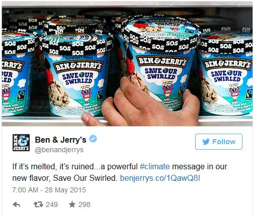
Ben and Jerry's Made a New Flavor to Raise Global Warming Awareness. The Week has the tasty details; here's a clip: "...
The
flavor combines raspberry ice cream, marshmallow and raspberry swirls,
and dark and white fudge ice cream cones. "We created a flavor to bring
attention to this historic issue and to send out our own SOS for our
planet," the company said in a news release Wednesday."
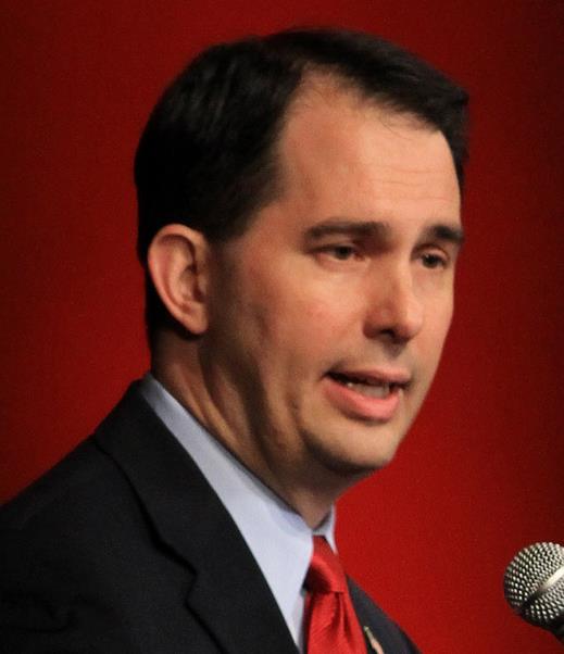
Walker's Denial of Climate Change is Extreme, Heartbreaking. Here's an excerpt of an Op-Ed from columnist Jim Hightower at
LaCrosseTribune.com: "...
Symptoms
include an obsessive impulse to deny that human-caused climate change
is happening, often accompanied by a feverish insistence that government
employees be banned from discussing it. Wisconsin Gov. Scott Walker is
suffering from this affliction. The Koch-funded governor and Republican
presidential wannabe is an ardent climate-change denier. And his state’s
public lands board has taken climate denial to Orwellian levels..."
File photo above: AP/The Des Moines Register, Charlie Litchfield.
Experts Warn Climate Change Affecting Tick Population. It's
another bad year for ticks. A friend recently pulled 236 ticks off his
dog after about an hour in the woods. Unreal. The trends in Minnesota
are similar to other northern tier states, including Maine, where
WMTW-TV in Augusta produced this video and story; here's a clip: "...
Elias
said the warmer and wetter the climate is, the more ticks there are.
"We have seen a steady increase in the number of ticks in the state of
Maine, starting in 1989, and we do have fluctuations from one year to
the next, but there is clearly an upward and sharp trend in the number
of deer ticks," Elias said. Experts said that is a problem because ticks
carry a number of diseases, including Lyme disease. "The concern is
that certainly last year we had 1,400 cases of Lyme disease, as well as
other co-infections, as we call them, and some other tick-borne
pathogens," said Jim Dill, of the University of Maine Cooperative
Extension..."
If You've Wondered Why So Many Politicians Deny Climate Change, Science Has Your Answer. Because people just want to fit in and be accepted by members of their "tribe". I wish I had a tribe. Here's an excerpt from
ThinkProgress: "...
But according to new research published in Nature Climate Change, there’s at least one statistically proven reason why more than 56 percent
of Congressional Republicans deny climate change: echo chambers. The
term “echo chambers” traditionally refers to situations where people
surround themselves with information they want to hear, and block out
the rest. We’ve known for a while that these present themselves in
climate politics; A 2014 study
suggested that the reason Americans haven’t fully accepted the
scientific consensus on climate change is because of echo chambers like
Fox News, where conservative viewers are “exposed only to content
consistent with their opinions, while shielded from dissenting views...”
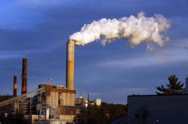
Norway's $900 Billion Sovereign Fund Told To Reduce Coal Assets. Reuters has the details; here's a link and excerpt: "
Norway's
$900 billion sovereign wealth fund, the world's largest, should cut its
exposure to the global coal industry and sell stakes in firms that
focus on the sector, a key parliamentary committee said on Wednesday.
The finance committee agreed in a bipartisan motion that the fund,
which owns about 1.3 percent of all listed companies globally, should
sell stakes in firms that generate more than 30 percent of their output
or revenues from coal-related activities..."
File photo above: "
In
this Tuesday Jan. 20, 2015 file photo, a plume of steam billows from
the coal-fired Merrimack Station in Bow, N.H. The Obama Administration’s
hotly debated plan to cut the amount of heat-trapping carbon dioxide
coming out of the nation’s power plants will save about 3,500 lives a
year from also reducing other types of pollutions, a new independent
study concludes." (AP Photo/Jim Cole, File).


No comments:
Post a Comment