88 F. high on Friday in the Twin Cities.
83 F. average high on July 24.
82 F. high on July 24, 2014.
.23" rain fell at MSP International Friday.
July 25, 2000: An F4 tornado hits the town of Granite Falls. One person is killed and there is 20 million dollars in damage.
July 25, 1915: Frost hits northeastern Minnesota. Source: Twin Cities National Weather Service.
Tell Me A StoryAll
of us are drowning in information, tweets and posts. 400 channels and
nothing's on right? So much data, so little wisdom. "I heard about it -
but what does it mean?"
From the first caveman's excited rant
about this new thing called "fire" to reading a newspaper or watching TV
news to find stories of relevance that resonate with our lives - it's
in our DNA to appreciate a good story.
Online or on your
smartphone the blur between media become inconsequential, but these
digital content centers are still the best source of perspective,
context and meaning.
Speaking of context: based on cooling degree
data we've spent 10 percent less than average cooling our homes so far
this summer. Blast-furnace heat is bubbling and boiling just south of
Minnesota. We get an occasional taste but not much more - a trend which
should continue into much of August. Historically the hottest days are
behind us now, but I expect a handful of 90-degree days into September.
A
potentially epic El Nino brewing in the Pacific, maybe the biggest
since 1997-98, would tend to keep a mild bias into the fall, winter and
spring of 2016. On paper.
But just like every storm is different
every El Nino is unique. Computer models help, but only to a point. The
future is largely unknowable.
* Image credit above
here.
Summer Temperatures, To Date. Temperatures have been average to slightly below average, as of July 23. Here are a few bullet points that caught my eye:
* Average temperature so far this summer (June 1 - July 23) is 70.8°
*
According to my calculations, taking the average temperatures for the
same period from 1981-2010 and averaging them, that average is 70.9°. So
it would appear we are about on average.
* Warmest
June 1 - July 23 on record is 77.1° in 1933. Coolest June 1 - July 23:
64.6° in 1915. (Random? Yes. But I had the numbers.)
* June was 0.8 degrees above average, with an average monthly temperature of 69.7.
* Warmest low temperature: 68 on July 18. (So no 70+ lows so far this summer).
* Two 90 degrees so far this summer.
Summer temperature data courtesy of AerisWeather meteorologist D.J. Kayer.
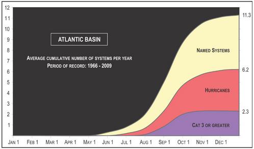
Why Haven't We Seen Any Hurricanes This Year?
Things may be heating up in the weeks to come; the peak of the season
is the second week of September, historically. Here's an excerpt at
thedenverchannel.com: "...
Just
because there hasn't been a named hurricane yet, and only three storms
have been named doesn't mean the season's a complete wash. It's just the
opposite. Hurricane season begins on June 1, but it usually doesn't
start to ramp up until the beginning of August, and more often than not,
into September..." (Image above: NHC).
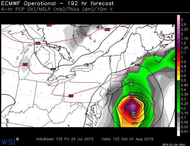
A Chance of "Danny"?
Confidence levels are still very low, but the ECMWF fires up a tropical
storm or hurricane off the east coast by the very end of July. The
European model solution above is valid Saturday morning, August 1,
showing what sure appears to be a full-fledged Hurricane Danny a few
hundred miles southeast of Long Island. ECMWF has spun up one or two
phantom storms in recent weeks - let's go a few runs and see if there's
any continuity here. Source: WSI Corporation.
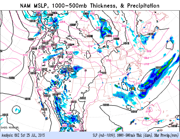
Relatively Dry into Monday.
The atmosphere over much of Minnesota and Wisconsin will be "capped"
for the next 48+ hours, too warm and dry in the low layers for T-storms
to flare up; no boundaries nearby to focus convection. A stray T-shower
is possible Sunday afternoon or evening; today should be dry statewide.
Models hint at highs near 90F Monday with a dew point in the mid-70s, a
late afternoon heat index of 95-100F.
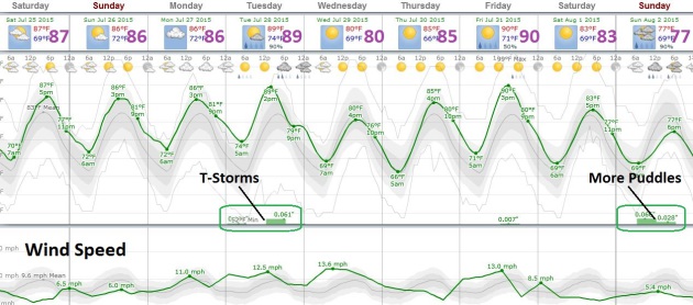
As 'Dog Days' As It's Going To Get.
We're on the northern fringe of the heat, and in spite of occasional
hot fronts no prolonged/sustained sauna-like conditions are brewing into
the first week of August. Most models keep the ridge axis west of
Minnesota, keeping us in a week northwest flow aloft much of the time,
meaning frequent sweeps of slightly cooler air, taking the edge off any
heat. The best chance of T-storms: Tuesday, again next Sunday. Source:
Weatherspark.
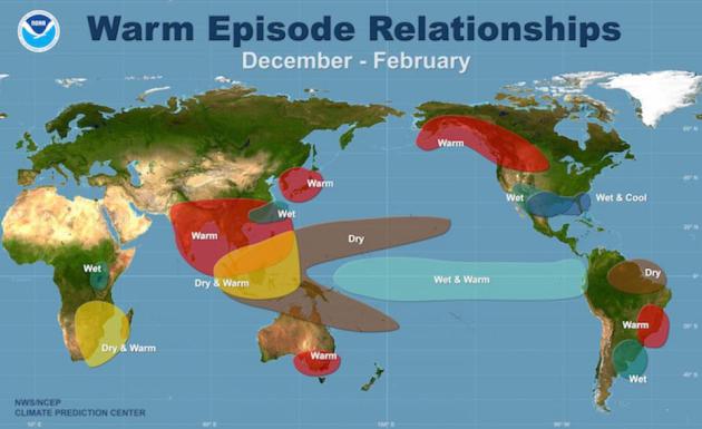
How This El Nino Is And Isn't Like 1997.
Just like no two storms are identical no two El Nino warming phases are
carbon copies. The stronger the warming signal in the Pacific, the
greater the odds of a turn to wetter weather, even flooding for
California by the winter months. Here's a snippet of a good explainer at
Climate Central: "...
We
think that the strength of [El Niño] is important,” L’Heureux said, but
the exact strength it achieves is no guarantee of impacts similar to
1997, “and that’s simply because there’s other stuff going on,” she
said. “El Niño is not the only ball game in town.” So where does that
leave us in terms of looking ahead to what El Niño might bring this
winter? We have an event that is looking more and more robust
(when comparing June 2015 to June 1997, the broad ocean temperature
patterns are very similar) and forecasting models are in pretty good
agreement that that event will strengthen as we head towards winter and
El Niño’s typical peak. But exactly when it will peak and what its final
strength will be is still uncertain. Even more uncertain is what those
other influences on U.S. weather will be..."
Hope Grows That El Nino Will Reach Northern California - And Key Reservoirs.
Every El Nino is different, but some of the warmest Pacific ocean water
since 1997-98 raises the odds of a wet winter season for California.
Here's an excerpt from
The Los Angeles Times: "...
That
could change if El Niño continues to muscle up, enabling storms to
elbow into the north. That's what happened during the two biggest El
Niños on record, in 1982-83 and 1997-98. "If this El Niño continues to
strengthen, it would not surprise me to see … all the lines extend
farther north," bringing the far reaches of the state into a zone where
odds favor a wet winter, NOAA Climate Prediction Center Deputy Director
Mike Halpert said. El Niño can shift the so-called subtropical jet
stream from the jungles of southern Mexico and Nicaragua north, over
Southern California and the southern United States, said Bill Patzert, a
climatologist with NASA's Jet Propulsion Laboratory in La Cañada
Flintridge..."
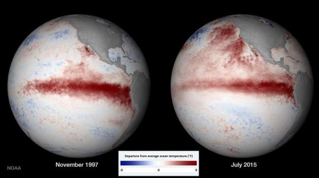
Image credit above: "
A comparison of
the November 1997 and July 2015 El Niños in the Pacific Ocean west of
Peru. Areas of warm water, shown in red, in 1997 contributed to
relentless, damaging storms in California that winter. Note: This image
has been edited to add a key and to express degrees in Fahrenheit." (National Oceanic and Atmospheric Administration Environmental Visualization Laboratory).
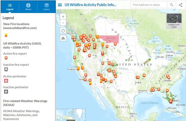
Scorched Earth: U.S. Wildfires Near Record Level. Here's the introduction to a good summary at
USA TODAY:
"
Wildfires have burned a phenomenal 5.5 million acres across the U.S.
so far this year, an area equal to the size of New Jersey. This is the
second-highest total in at least the past 25 years, according to data
from the National Interagency Fire Center in Boise. Only 2011, which saw
5.8 million acres charred as of July 23 of that year, had more. On
average, at this point in the year, 3.5 million acres would have
burned..." (Map credit above:
ESRI).
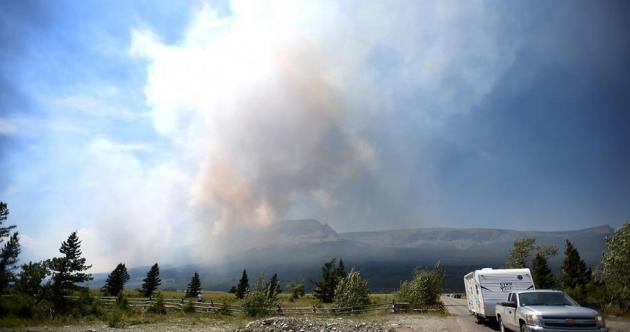
A Raging WIldfire Is Threatening the Iconic Glacier National Park. Here's a link to a story at
Mashable: "
The
West's wildfire woes have spread to one of America's most iconic, and
endangered, national parks: Glacier National Park in Montana. The park
is already considered extremely vulnerable to global warming, with
receding glaciers that may force the park to change its name by the
middle of this century. Now, it is facing a wildfire that has been
spreading rapidly since it began on Tuesday afternoon about six miles
east of Logan Pass..."
Photo credit above: "
Visitors leave as part of a mandatory evacuation, Wednesday, July 22, 2015, near East Glacier Park, Montana." Image: Brenda Ahearn/The Daily Inter Lake via AP/Associated Press.
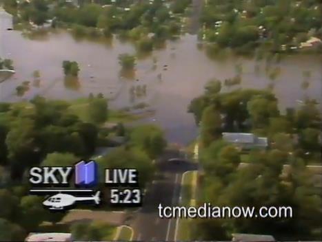
Remembering The July 23, 1987 Twin Cities "Superstorm".
This is the storm that spawned 11" of rain for parts of the metro area,
closing a stretch of I-494, as well as tornadoes for the northwest
suburbs. Details via
TC Media Now: "
Continued
day after coverage of the record breaking Super Storm "of the century"
that pounded the Twin Cities on July 23, 1987 with rain, tornadoes,
flooding, hail and wind. On this report from July 24 Paul Douglas
examines the patterns of the storms, Paul Magers, Diana Pierce anchor
coverage along with reports from Dennis Feltgen, Kevin MacDowell,
Kirstin Lindquist and others."
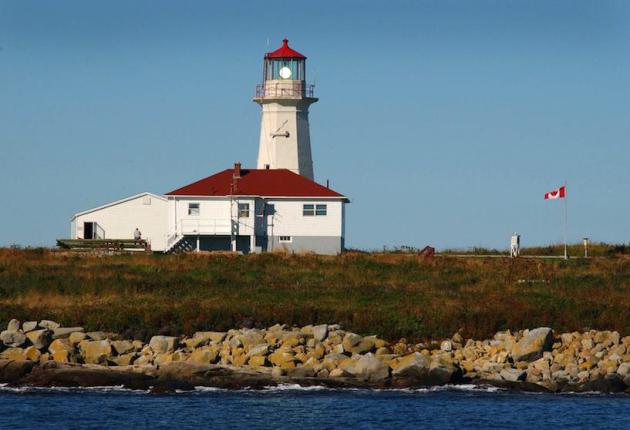
The Tiny Islands Where Canada and America Are At War. I had no idea - here's a snippet of a story at
Maclean's: "
Canada
is one wrong move away from a border war with the United States—if you
believe a group of boiling-mad Maine lobstermen. Unfathomable as armed
conflict between Canada and the United States seems, if it’s going to
happen, it will be in the ocean between Maine and New Brunswick, where
two tiny, treeless islands—North Rock and Machias Seal—are the last
remaining disputed lands between the two countries..."
Photo credit above: "The
Canadian flag flutters in the breeze Monday, Sept. 8, 2003, by the
lighthouse at Machias Seal Island. The Canadians man the lighthouse on
this island claimed by the US and Canada in The Gray Zone waters between
the two countries." (Fred J. Field/CP).
In The War of 2050, The Robots Call The Shots. Here's the intro to a fascinating story at defenseone.com: "In April, thought leaders from the Defense Department, the U.S.
Army Research Lab, the Institute for Defense Analysis, and national
security thinkers across academia met for a two-work workshop on the
next three and a half decades of war. The report
they recently produced reads like a Tolkien-esque saga set in the
future, a fascinating mashup of futuristic concepts, far-off
capabilities, and emergent technologies that play off one another,
competing and evolving at hyperspeed. Among the report’s most
significant conclusions: faster “battle rhythm” will increasingly push
human beings out of the decision-making loop. The future of war belongs
to the bots..."
SATURDAY: Warm sunshine. Dew point: 65. Winds: SE 5-10. High: 89
SATURDAY NIGHT: Mostly clear and warm. Low: 72
SUNDAY: Sunny start, stray T-shower late? Winds: Southeast 10. High: 91
MONDAY: Steamy, PM pop-up T-storms. Dew point: 71 Wake-up: 74. Heat index: 95-100F. High: 91
TUESDAY: Uncomfortable. Few storms. Dew point: 74. Feels like 100F+ late. Wake-up: 75. High: 93
WEDNESDAY: Sunny, turning less humid. Dew point: 60. Wake-up: 73. High: 86
THURSDAY: Blue sky, pleasantly warm, slight dip in humidity. Wake-up: 66. High: 87
FRIDAY: Muggy sunshine, late-day thunder. Wake-up: 69. High: 89
Climate Stories....
Jeb Bush Calls for End To Fossil Fuel Subsidies. Here's a clip from an update at
NationalJournal: "eb Bush wants to get rid of tax credits for the oil and gas industry. "
I
think we should phase out, through tax reform, the tax credits for
wind, for solar, for the oil and gas sector, for all that stuff," the
2016 Republican candidate said in New Hampshire on Wednesday, according to a video recorded by grassroots environmental group 350 Action..."
July 23 photo credit: Ian Thomas Jansen-Lonnquist/The New York Times.
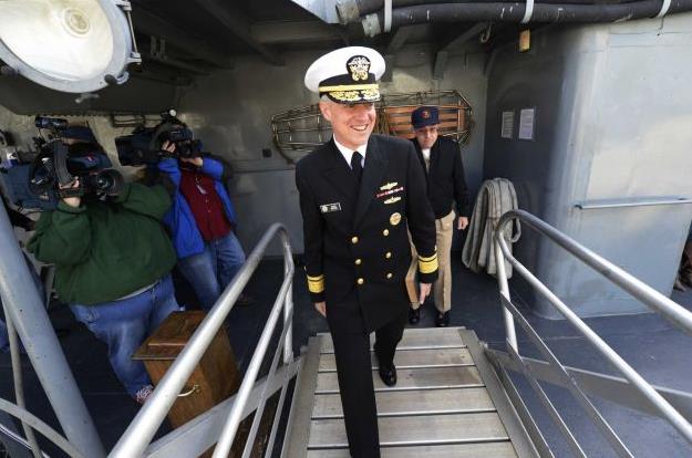
Navy Climate Change Expert Sees Opponents Ignoring Science.
I know Admiral Titley - he's a friend, classmate and colleague, and
he's right. This is no longer about science and facts. Here's an excerpt
from
Times Union: "...
Climate
deniers who claim that thousands of scientists are engaging in a global
fraud are "one step way from a conspiracy theory" that is too
fantastical to be even feasible, he added. "Think about it. We have an
administration that could not roll out a proper health care website. You
think they can manage a global scientific conspiracy? They could not do
it if they wanted to," said Titley, who also holds a doctorate in
meteorology. And he scoffed at the idea that scientists are deliberately
lying about climate change just to obtain short-term research grants.
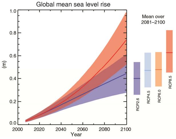
When he headed the Navy's climate change task force, the group looked at
issues like rising sea levels, which is one outcome of global warming.
Naval bases around the world will be affected and planners have to be
ready for it, he said..."
Photo credit above: "
Rear
Admiral David Titley tours the USS Slater in Albany, N.Y. April 26,
2012, as part of the United States Navy's 50/50 Program, an outreach
effort that features 50 senior Navy leaders in 50 U.S. cities." (Skip Dickstein/Times Union archive)
 A New Climate Change Danger-Zone?
Elizabeth Kolbert takes a look at the recent fuss over climate
scientist James Hansen's latest research on the rate of Antarctic ice
and the level of risk posed to coastal cities. Here's an excerpt at
The New Yorker: "...
In a paper set to appear online this week in Atmospheric Chemistry and Physics, the modellers, led by James Hansen, the former director of NASA’s
Goddard Institute for Space Studies, warn that an increase of two
degrees Celsius could still be enough to melt large portions of
Antarctica, which, in turn, could result in several metres’ worth of
sea-level rise in a matter of decades. What’s important about the paper
from a layperson’s perspective—besides the fate of the world’s major
coastal cities, many of which would be swamped if the oceans rose that
high—is that it shows just how far from resolved, scientifically
speaking, the question of danger levels remains. And this has important
political implications, though it seems doubtful that politicians will
heed them..."
What Religion Can Teach Climate Scientists. Climate activist Bill McKibbon has an Op-Ed at
The Boston Globe; here's an excerpt: "...
Religious
environmentalism hasn’t conquered every territory — many evangelical
churches remain suspicious of the fight. Even that is changing, though: A
former New England physician, Matthew Sleeth, organized a nonprofit
called Blessed Earth
and speaks to conservative congregations across the country. Polling
data show such efforts find increasing favor with young evangelicals. In
the end, it may be less the political power of faith communities that
matters and more their ability to transform the bleak message of
scientists into something that more people can hear. Faith-based
environmentalists, after all, are allowed to have some hope that if they
work hard, the world might meet them halfway..."
Martin O'Malley's Link Between Climate Change and ISIS Isn't Crazy. Was
the most severe drought on record a material factor in Syria's
unraveling? The Pentagon refers to climate change as a "force
multiplier". The rise of ISIS may be Exhibit A. Here's an excerpt from
an article at
The Atlantic: "...
But
O’Malley’s comment isn’t as weird as it might initially seem. There’s
an established body of work that draws a connection between drought,
resource scarcity, and conflict in general. In a 2013 article for The Atlantic, William Polk, a historian and former adviser to President Kennedy, noted a possible relationship between Syria’s civil war and devastating 2006-2011 drought. “As
they flocked into the cities and towns seeking work and food, the
‘economic’ or ‘climate’ refugees immediately found that they had to
compete not only with one another for scarce food, water, and jobs, but
also with the existing foreign refugee population,” he wrote..."
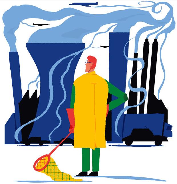
A "Third Way" To Fight Climate Change.
Will we see the breakthroughs and price drops in carbon capture
required to make this a viable way to address climate change? I wouldn't
rule anything out at this point. Here's a snippet from a
New York Times article: "
Two options for dealing with climate change
— reducing greenhouse gas emissions through a global agreement, and
geoengineering proposals such as injecting sulfur into the stratosphere —
tend to dominate current thinking. But there is a “third way” that is
almost entirely neglected in political negotiations and public debate.
It involves capturing carbon dioxide from the atmosphere and storing it
or using it to create things we need. Because of the scale of the
climate problem, I believe that in coming decades third-way technologies
will become a major focus of activity..."
Graphic credit above:
Alec Doherty.
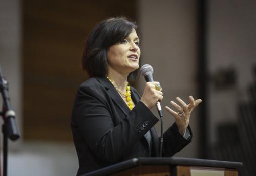
Minneapolis Mayor: Debate over Climate Change Not An Issue at Pope's Summit. Here's the intro to a story at
The Star Tribune: "
After
two days of meetings in Rome with mayors from around the world on
climate change, Minneapolis Mayor Betsy Hodges said she realized a
familiar topic at home hadn't been part of the conversation. Leaders of
cities from outside the U.S. didn't seem to have to spend much time
debating the matter with people who don't believe in climate change, the
mayor said in a call with local media on Wednesday. "I noticed
that, probably about halfway through today, and just realized that
climate change deniers cast a pall on the conversation in the United
States," Hodges said. "And that as far as I can tell, it does not extend
to anywhere else in the world..."
Hansen Paper: "2C Temperature Rise is Very Dangerous". Here's an excerpt of the paper abstract at ACPD: "There
is evidence of ice melt, sea level rise to +5–9 m, and extreme storms
in the prior interglacial period that was less than 1 °C warmer than
today. Human-made climate forcing is stronger and more rapid than paleo
forcings, but much can be learned by combining insights from
paleoclimate, climate modeling, and on-going observations. We argue that
ice sheets in contact with the ocean are vulnerable to non-linear
disintegration in response to ocean warming, and we posit that ice sheet
mass loss can be approximated by a doubling time up to sea level rise
of at least several meters. Doubling times of 10, 20 or 40 years yield
sea level rise of several meters in 50, 100 or 200 years. Paleoclimate
data reveal that subsurface ocean warming causes ice shelf melt and ice
sheet discharge..."


No comments:
Post a Comment