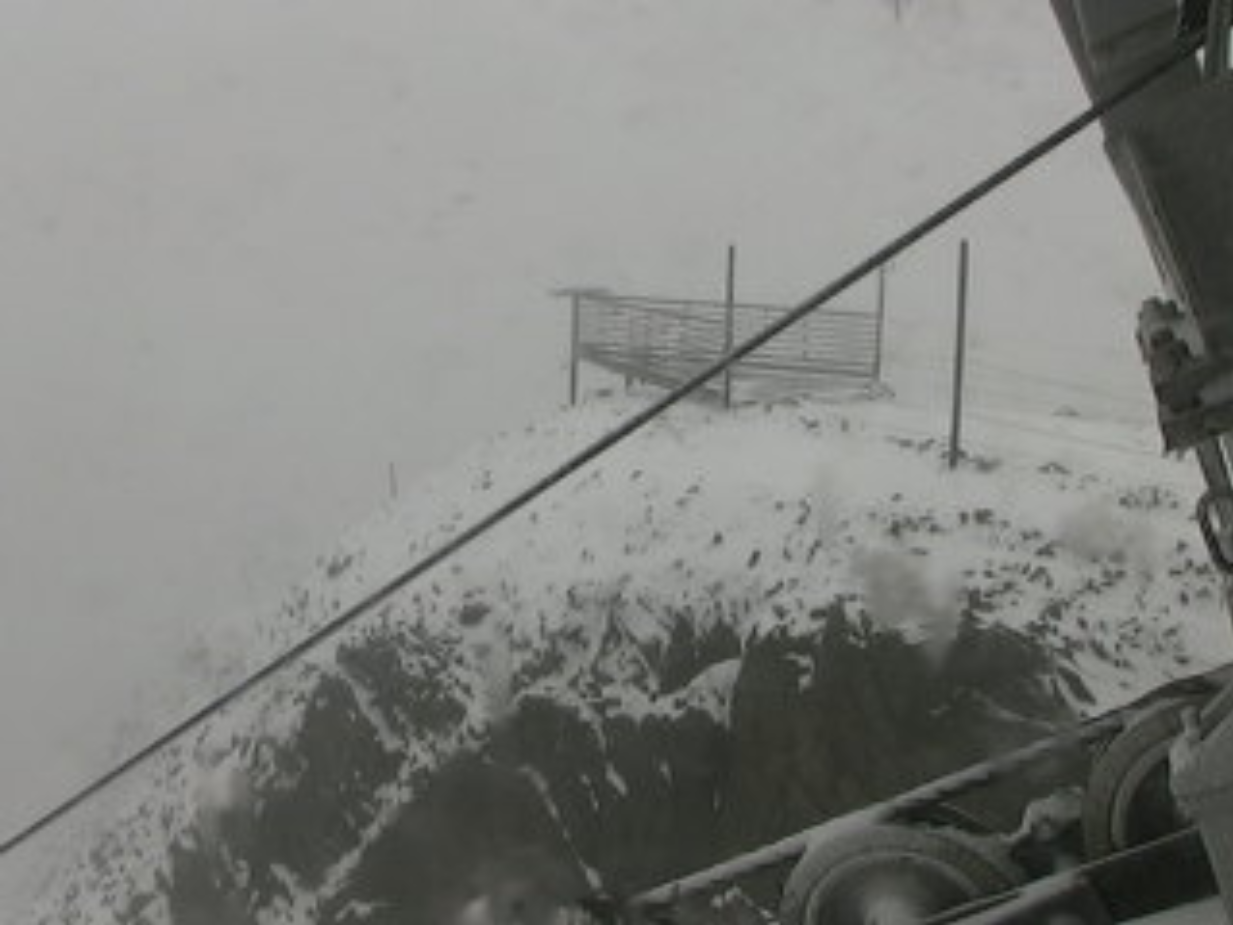
Believe it or not, this was the view from Lone Peak in Big Sky, MT at 11,166 ft. on Monday afternoon. Yes, that's snow! The same storm system responsible for severe weather across parts of the Midwest was also responsible for this scene in the Northern Rockies.
Check out the latest webcam from Big Sky Resort HERE:
An Analog Life
By Paul Douglas
I'm no Luddite; I'm addicted to technology like everyone else. I experience mild anxiety disorder when I can't access Google Maps or stump Siri on my new iPhone 7(!) Yes, I'm an early adopter. And yet...
I have no interest in rewinding the clock - but digital only goes so far. I find it vaguely reassuring that vinyl still trumps MP3. My digital camera doesn't capture the magic of Kodachrome. Film looks far better than video. And for that matter a face-to-face meeting usually gets better results than an e-mail or a call. That stuff your mom taught you is true: the old ways are often best. For weather that means shoving the models aside and going with gut instinct. 1 km resolution satellite pics are great. So is looking out the window to "read the sky", factoring cloud types and trends. Take advantage of computers - but rely on your senses.
Storms rumble across the state today, and a few may turn severe. Dew points in the mid-70s will make it feel like mid-90s by late afternoon. Dew points drop into the 50s tomorrow, taking the edge off the heat.
Highs reach 85 to 90F the next 5 days before a stronger puff of Canadian air arrives next week. Hottest days behind us? Probably.
______________________
MONDAY NIGHT: Muggy, few T-storms possible late. Low: 74. Winds: SE 15.
TUESDAY: Strong T-storms; feels like 95F. Dew point: 73. High: 88. Winds: SSE 15
TUESDAY NIGHT: Graual clearing. Low: 63. Winds: W 10-15
WEDNESDAY: Sunny, breezy, less humid. High: 84
THURSDAY: Sunny and warmer. fells like July. Dew point: 58. Wake-up: 66. High: 88
FRIDAY: Sunny, bordering on hot again. Wake-up: 67. High: 90
SATURDAY: Muggy, few pop-up T-storms. Wake-up: 69. High: 88
SUNDAY: Blue sky, another drop in humidity. Wake-up: 67. High: 83.
MONDAY: Warm sun, enjoying August. Wake-up: 64. High: 84.
________________________
This Day in Weather History
July 28th
1987: Heavy rain at La Crosse, WI. Their rain bucket picked up 5 inches.
________________________
Average High/Low for Minneapolis
July 28th
Average High: 83° (Record: 100° set in 1955)
Average Low: 64° (Record: 50° set in 1981)
________________________
Sunrise/Sunset Times for Minneapolis
July 28th
Sunrise: 5:54am
Sunset: 8:44pm
_________________________
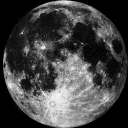
Moon Phase for July 28th at Midnight
2.2 Days Until Full Moon
______________________________
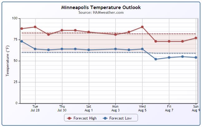
Minneapolis Temperature Trend
Even though it has been a little warm and sticky as of late, it's hard to complain about our summer so far. Through July 26th, Minneapolis has only had two 90°+ days and according to NOAA's NCDC (1981-2010), we should have had about seven 90°+ days so far. Looking at the extended forecast below, it looks like Tuesday will be another warm and sticky one, but we get back to near average on Wednesday and look to stay near there through early August.
_____________________________
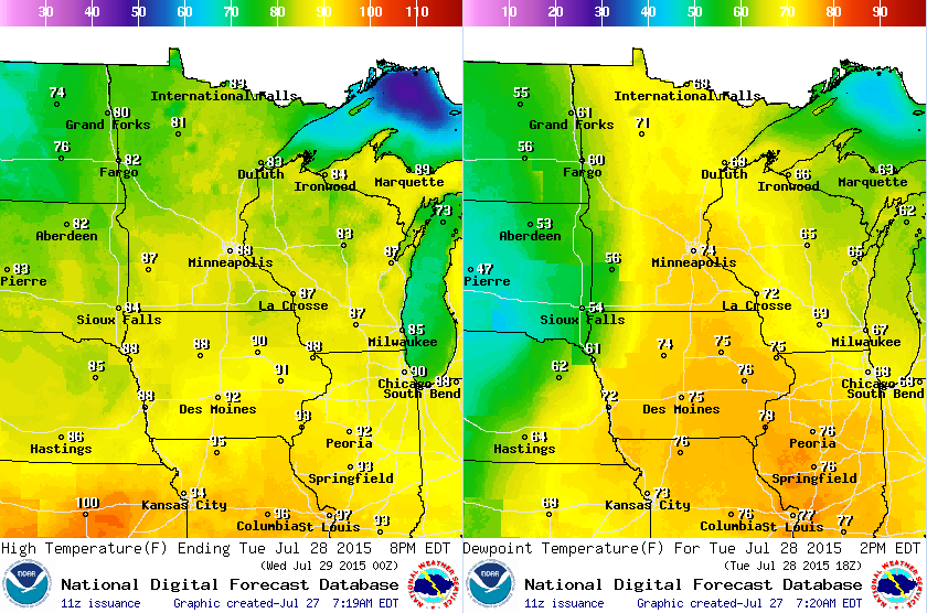
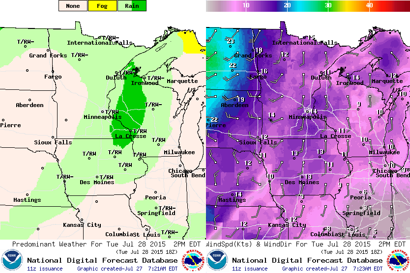
Weather Outlook for Tuesday
Tuesday looks to be warm and sticky again. Temperatures (left) will warm into the upper 80s across the southern half of the state, while dewpoints (right) will warm into the 60s and 70s ahead of a cold front that will plow through late in the day.
Weather Outlook for Tuesday
Scattered showers and storms look to be ongoing across the region early Tuesday with additional thunderstorms developing later in the day. Keep in mind that some of the storms could be strong to severe with heavy rain. Note also the winds picking up across the Dakotas late in the day, this will become more of a factor for us on Wednesday as strong, gusty winds help to flush out the muggy weather midweek.
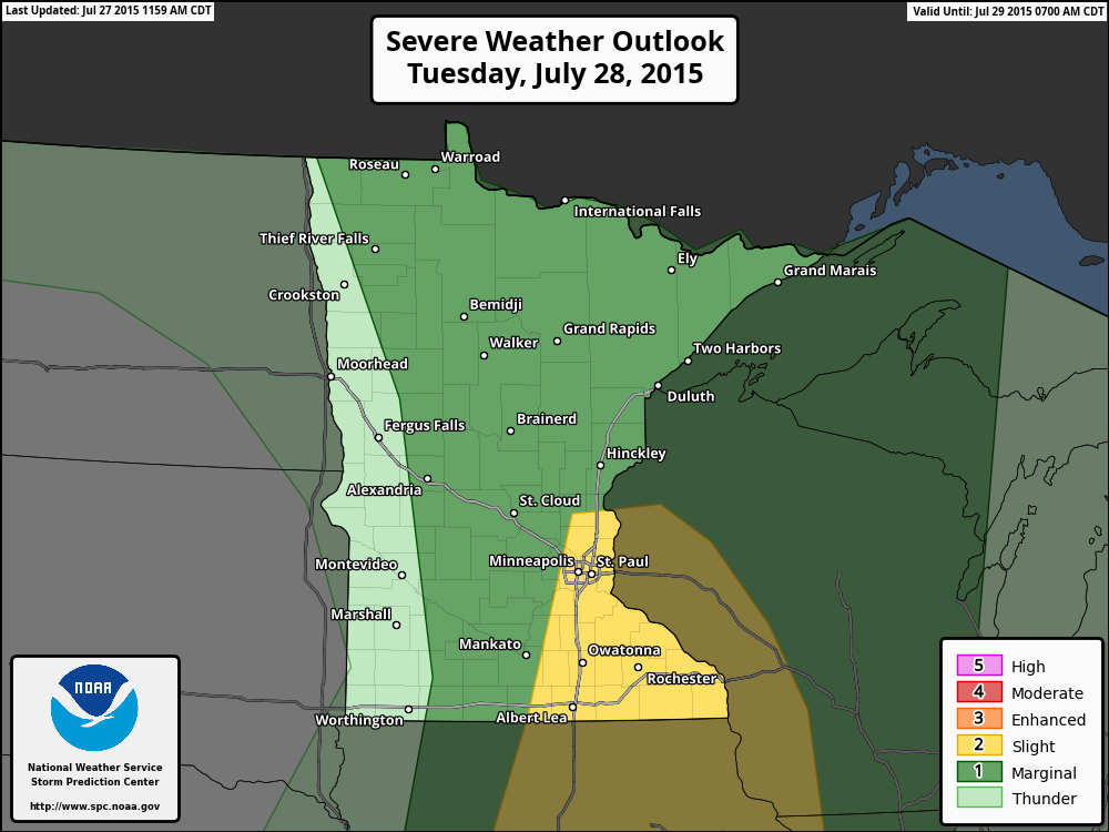
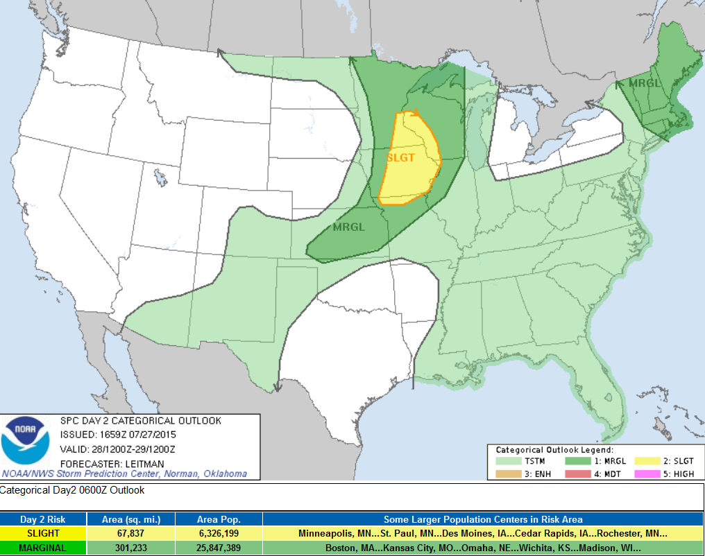
Severe Threat Tuesday
...SYNOPSIS... A PROGRESSIVE UPPER PATTERN WILL BRING A TROUGH EASTWARD FROM THE NORTHERN HIGH PLAINS TO THE UPPER MS VALLEY BY 12Z WED. A SURFACE COLD FRONT ASSOCIATED WITH THIS SYSTEM WILL TRACK EAST SOUTHEAST ACROSS THE NORTHERN AND CENTRAL PLAINS DURING THE MORNING AND EXTEND FROM CENTRAL WI SOUTHWESTWARD THROUGH NORTHERN MO AND INTO SOUTHERN KS BY WEDNESDAY MORNING. THIS WILL SERVE AS A FOCUS FOR STRONG TO SEVERE THUNDERSTORM DEVELOPMENT FROM THE MID/UPPER MS VALLEY INTO PARTS OF THE CENTRAL PLAINS. FURTHER EAST...A SERIES OF SHORTWAVE IMPULSES WILL MIGRATE EAST/SOUTHEAST ACROSS NEW ENGLAND AS AN UPPER TROUGH OVER NORTHERN QUEBEC SHIFTS SOUTHEAST TOWARD NEW BRUNSWICK. SCATTERED THUNDERSTORMS...SOME STRONG...WILL BE POSSIBLE DURING THE AFTERNOON.
...UPPER MIDWEST/MO VALLEY TO THE CENTRAL PLAINS... CONVECTION WILL LIKELY BE ONGOING ACROSS PARTS OF MN/WI AND PERHAPS AS FAR SOUTH AS IA TUESDAY MORNING. THIS EARLY-DAY CONVECTION MAY PRODUCE SOME MARGINALLY SEVERE WIND/HAIL. THIS EARLY CONVECTION ALSO WILL COMPLICATE THE SCENARIO FOR AFTERNOON DESTABILIZATION ACROSS THE REGION DUE TO CLOUD DEBRIS AND OUTFLOWS TRAVERSING THE AREA. FORECAST GUIDANCE CONTINUES TO INDICATE THE BEST AREA FOR AIRMASS RECOVERY/DESTABILIZATION WILL BE NEAR THE SOUTHERN EDGE OF MORNING CONVECTION AND RESIDUAL CLOUD SHIELD FROM FAR SOUTHERN MN/SOUTHWEST WI INTO IA AND PERHAPS AS FAR SOUTH AS NORTHERN MO. HERE...A NARROW WARM SECTOR AHEAD OF THE SURFACE COLD FRONT WILL EXIST WITH DEWPOINTS IN THE UPPER 60S TO LOW 70S...RESULTING IN POCKETS OF MODERATE INSTABILITY DURING PEAK HEATING. STRONGER FORCING AND EFFECTIVE SHEAR WILL RESIDE JUST NORTH OF THE BEST THERMODYNAMICS BUT SHOULD STILL BE SUFFICIENT FOR ORGANIZED BOWS/LINE SEGMENTS...AND PERHAPS AN ISOLATED SUPERCELL OR TWO...CAPABLE OF HAIL AND STRONG WINDS. TO THE SOUTHWEST INTO FAR SE NEB AND SOUTHERN/CENTRAL KS...MORE ISOLATED...HIGH-BASED CONVECTION IS EXPECTED TO DEVELOP ALONG THE COLD FRONT. STEEP LAPSE RATES AND A DEEPLY MIXED BOUNDARY LAYER WILL BRING A RISK FOR STRONG DOWNBURST WINDS WITH ANY STORMS THAT FORM IN THIS AREA.
__________________________________
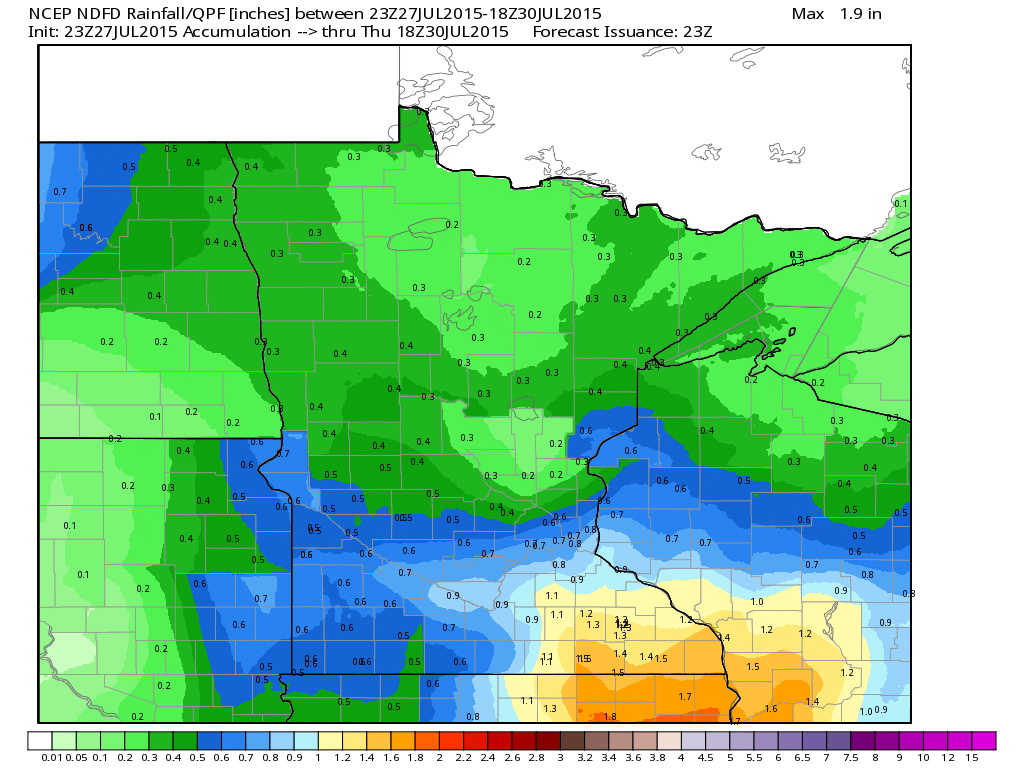
Rainfall Outlook
Rainfall potential through midweek looks fairly impressive across the southern part of the state with as much as 1"+ possible. Keep in mind that within heavier thunderstorm activity, heavy rainfall amounts can't be ruled out.
_________________________________
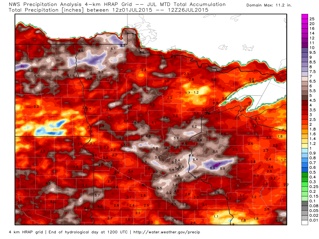
Rainfall Month To Date
It has already been a fairly wet month across the region. Note that the 2"+ rainfall (red coloring) covers much of the state, while nearly 4" to 6"+ seems pretty widespread as well.
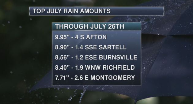
Wet July Thus Far...
Here are some of the highest rainfall tallies from local Minnesota CoCoRaHs sites so far this month. Note the near 10" 4 miles south of Afton, MN!
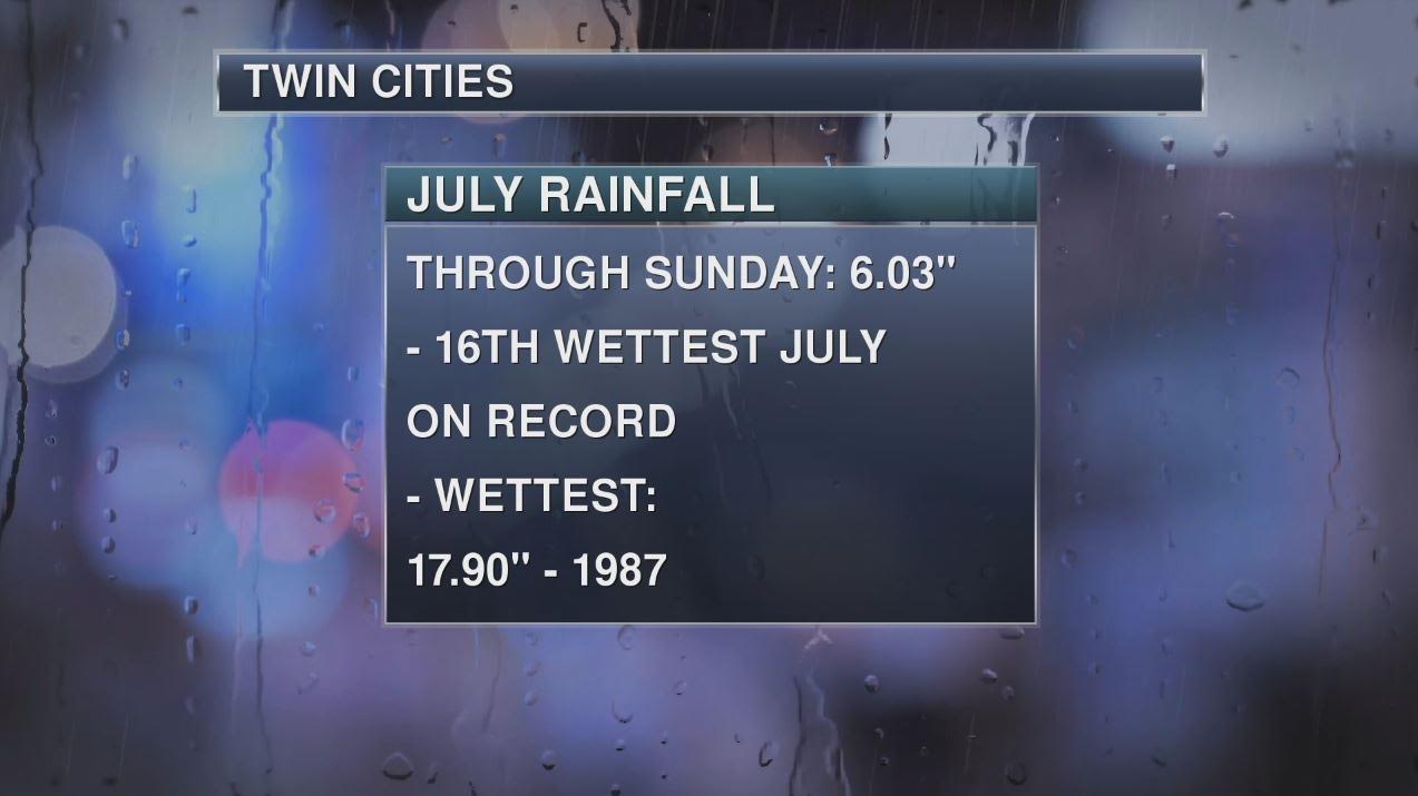
16th Wettest July on Record for Minneapolis
As of July 26th, Minneapolis has seen it's 16th wettest July on record with 6.03" of rain. Interestingly, MSP would still need an additional 10"+ to get close to the wettest July on record of 17.90" set in 1987.
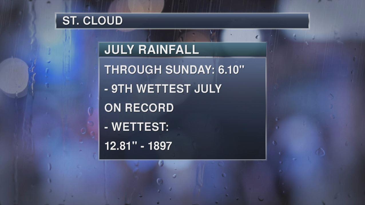
8th Wettest July on Record for St. Cloud, MN
As of July 26th, St. Cloud, MN has seen it's 9th wettest July on record with 6.10" of rain. The wettest July on record was set in 1897 with 12.81" of rain.
_____________________________________
National Weather Outlook
A vigorous area of low pressure tracking along the international border through midweek will be responsible for widely scattered strong to severe storms across parts of the Midwest/Ohio Valley through Wednesday. The tightly wound nature of the storm system will also make for breezy winds for locations close to the storm system over the next several days as well.
________________________
Severe Threat Tuesday
Severe Threat Wednesday
______________________________________
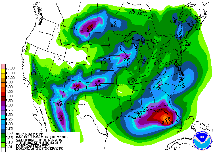
5 Day Rainfall Forecast
According to NOAA's WPC, the 5 day rainfall forecast suggests heavy pockets of rain across parts of the High Plains, Central U.S. and into the Southeast. Flooding and Flash Flooding be an issue for some where the heaviest rainfall sets up within these areas.
_______________________________
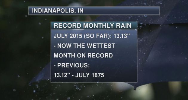
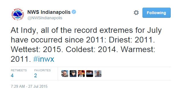
Interesting Weather Stats: Indianapolis, IN
It has been a very wet month of Indianapolis, IN as well! In fact, so wet that not only is the 13.13" of rain (through July 26th) good enough for the wettest July on record, but it's also good for the wettest month on record, beating that of 13.12" set in 1875
Here are a few more interesting weather stats from the National Weather Service in Indiana @NWSIndianapolis
___________________________________
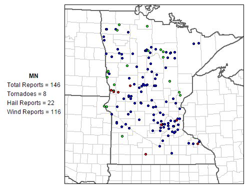
MN Storm Reports This July
July has been a fairly active month. According to NOAA's SPC, there have been nearly 150 severe weather reports, 8 of which were tornadoes. However, most of the reports were wind damage reports due to multiple straight line wind events that rumbled across the state earlier this month.
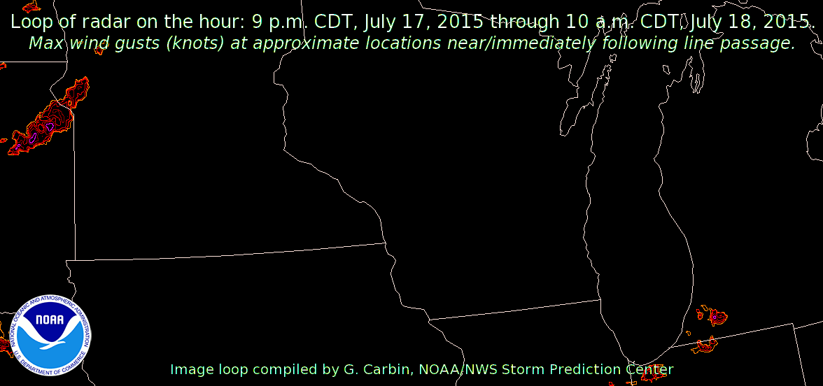
July 17th-18th, 2015 Damaging Wind Event
Here is one of those particular events that unfolded July 17th-18th with multiple wind damage reports that included parts of the Twin Cities. This line of storms was also responsible for 2 of the 8 tornado reports so far this month.
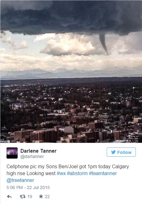
Tornadoes, Funnel Clouds and Hail, Oh My!
Last week, parts of Canada were getting hit by severe storms. A funnel cloud and large hail was reported in Calgary.
A tornado touched down southwest of Calgary on Wednesday, Environment Canada officials confirmed after lifting warnings for the city and surrounding communities. A line of thunderstorms brought funnel clouds, rain, and hail as large as golf balls to south Calgary as it moved over the city. Environment Canada issued a warning for Calgary and several other Alberta communities after a tornado was reported 10 kilometres north of Priddis at 12:53 p.m. MT, according to Environment Canada. "We have a storm spotter who did report a tornado on the ground," said Bill McMurtry, a warning preparedness meteorologist with the agency. "Since that time [we] have had video confirmation. It looks like we had a brief touch down of a tornado for areas to the southwest of the city." Trees may have been damaged when the tornado touched down, he added. There are also reports of damage on the nearby Tsuu T'ina First Nation. "It appears at this time that the City of Calgary has had another brush with a major weather event, but we don't believe we sustained any major damage," said Tom Sampson, chief of the Calgary Emergency Management Agency.
See the full story from CBC HERE:
(Image courtesy: @dartanner via Twitter)
____________________________________________
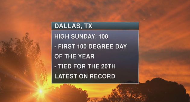
Dallas, TX Heat
It's hot and sticky across the Central U.S., but interestingly, Dallas, TX saw its first 100° day of 2015 finally on Sunday. That makes it the 20th latest first 100° day on record.
Thanks for checking in and have a great rest of your week and don't forget to follow me on Twitter @TNelsonWX

No comments:
Post a Comment