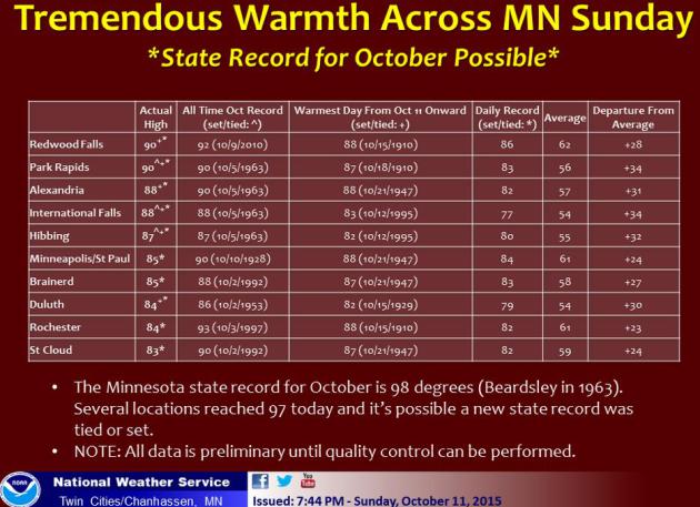
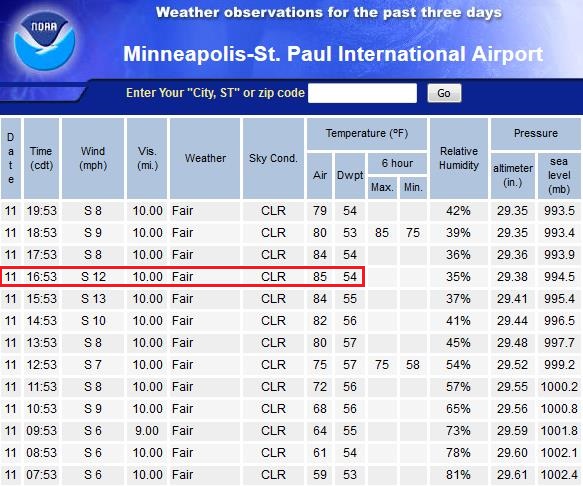
85 F. high in the Twin Cities Sunday, breaking the old record of 84F in 1930.
61 F. average high on October 11.
57 F. high on October 11, 2014.
October 12, 1969:
Snow accumulated in several locations. Minneapolis received 2 inches,
while St. Cloud record 3.6 inches, Redwood Falls had 1.7 inches, and
Springfield recorded 1.5 inches.
October 12, 1918:
Dry fall weather set the stage for a dangerous fire threat. Several
fires roared through large area of Carlton and St. Louis County. Hardest
hit were the towns of Cloquet, Moose Lake and Brookston. The Carlton
County Vidette called it a "Hurricane of burning leaves and smoke." At
least 453 people died, possibly as many as 1,000. Over 11,000 people
were homeless.
October Daydream
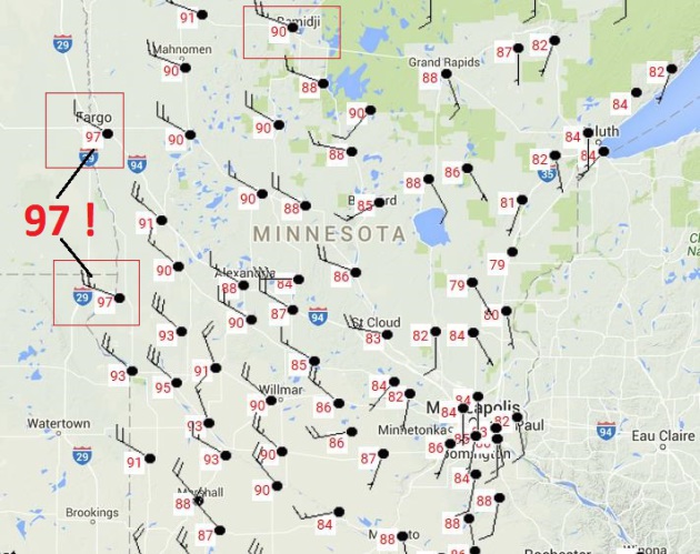
97F in western Minnesota Sunday - Gusty 40 MPH Reality Check Today
I
had the most amazing dream last night. It was mid-October yet
waterskiers were tearing up the bay behind our house; parades of
motorcyclists soaking up 80-degree sunshine; moms smearing sunscreen on
their toddlers.
Did we really hit a record 85F in the metro
yesterday, or was it all a dream? We may have tied the all-time
Minnesota heat record for October. Upper 90s in western Minnesota, on
October 11? Surreal.
I hate to see summer end. It's like saying goodbye to a dear friend you won't see for another year.
Sunday's
warm embrace gives way to window-rattling winds today as our
hot-weather-bubble bursts. The sharper the drop in temperature, the
faster winds will blow to keep the atmosphere in equilibrium.
Expect gusts over 40 mph as temperatures droop into the 50s. So this is what October feels like.
A quiet midweek gives way to a reinforcing cold frontal passage
Thursday, setting the stage for the first frost of the season in the exurbs
Saturday
morning. Lakeville, Anoka, Arden Hills and Stillwater may see an end to
the growing season; the close-in suburbs may remain frost-free another 2
weeks.
You can thank (or blame) El Nino. A warm, Pacific bias will flavor our weather into late October.
"Tremendous Warmth". Not my words, but from the
Twin Cities office of the National Weather Service.
97F. on the 11th day of October? That's pretty...unusual. Temperatures
were as much as 32F warmer than average. Freakish warmth, considering
the sun was as high in the sky as it was on March 1.
October Heat Spike.
Yes, data confirms that both Moorhead and Wheaton, Minnesota
experienced 97 degrees Sunday afternoon, very close to a statewide
record. Bemidji saw 90F, 4 degrees hotter (and considerably less humid)
than Miami.
Record-Breaking.
The old record high for October 11 at KMSP was 84F in 1930. At 4:53 PM
the airport clocked in at 85F with a dew point of 54. Perfectly
average...for Palm Springs.
Full-Frontal Leef Peeping.
For the record I had shorts on too, but I kept my shirt on (to avoid
the paramedics from showing up). Don't want to alarm the neighbors. But
sunbathing under a fully ripened sugar maple on October 11? You don't
see that very often. Thanks to Pat Collins for the pic from Cedar Lake.
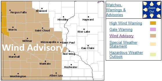
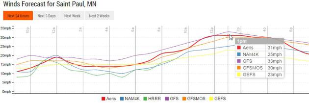
Wind Advisory.
A sharp drop in temperature will put the squeeze on our atmosphere
(quite literally) resulting in sustained winds close to 25-30 mph by
early afternoon, a few gusts as high as 45 mph, capable of minor damage
and even a few sporadic power outages. Details via NOAA:
A COLD FRONT IS PUSHING ACROSS THE EASTERN DAKOTAS EARLY THIS
EVENING. WINDS IMMEDIATELY BEHIND THE FRONT HAVE BEEN GUSTING
BETWEEN 50 AND 60 MPH AND THESE WINDS WILL BE PUSHING INTO WESTERN
MINNESOTA BY MID EVENING. THE WIND ADVISORY HAS BEEN EXTENDED
IN THOSE AREAS TO INCLUDE THIS EVENING.

A WIND ADVISORY REMAINS IN EFFECT MONDAY FOR AREAS WEST OF A LINE
FROM LONG PRAIRIE TO ST CLOUD...TO THE TWIN CITIES METRO...AND
ALONG I-35 INTO IOWA. STRONG WINDS WILL REDEVELOP MONDAY MORNING
WITH SUSTAINED WINDS OF 30 TO 40 MPH...WITH GUSTS OF 45 TO 55 MPH.
Serious Frizz.
Today will be the definition of a bad hair day with sustained winds
close to 30 mph between noon and 3 PM, gusts as high as 45 mph from the
northwest. Super-blustery.
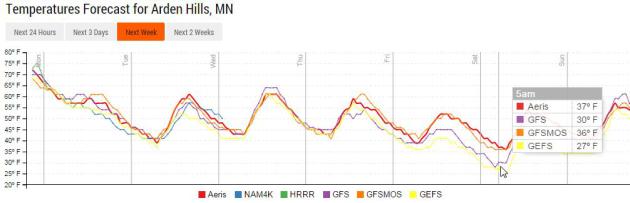
Frost Potential Saturday Morning.
It's still early for (attempted) specifics, but many of the models show
a frost risk for the Twin Cities suburbs Saturday morning. This assumes
skies clear and winds are light or calm under an approaching bubble of
Canadian high pressure. The best chance: outside the 494/694 beltway.
Source: Aeris Enterprise.
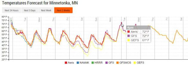
Warming Up Again Early Next Week.
My goal is to wear shorts in November, which would bring boasting
rights (at least for Minnesota), but be really troubling at the same
time. I can't promise that, but hold off on putting the T-shirts and
shorts into cold storage. Models hint at upper 60s and low 70s close to
home by Monday and Tuesday of next week.
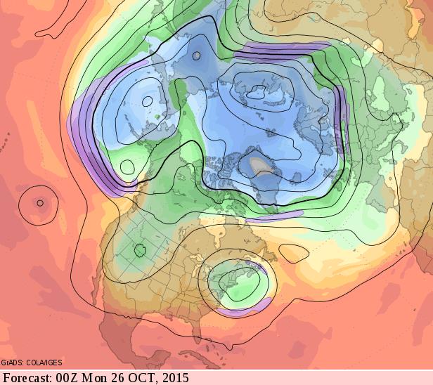
Late Month Omega Block?
My confidence level for a 500mb wind forecast 2 weeks out is low. No,
very low. But the GFS model hints at a blocking pattern by Sunday,
October 25, with stormy weather for New England and the Rockies, a
relatively mild ridge of high pressure over the Midwest. We'll see.
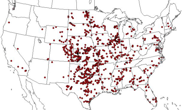
This is the Fourth Year In A Row for a Below Average Tornado Count Across the USA.
For the record: Minnesota experienced 24 tornadoes, 20 in Wisconsin -
also fewer than average. Meteorologist John Belski has an interesting
blog post on another mercifully-slow year for tornadoes at
WLKY.com
in Louisville; here's his intro: "The tornado count across the U.S. is
up this year over last. In fact this is the most active year since 2011.
However, as of now the total count is still about 20% under the
average. 2015 tornadoes..... The actual confirmed tornado count is 877,
but that is only through July 31. The total through today is probably
around 930. The long term average is 1250 to 1300 tornadoes a year in
the U.S..."
Image credit:
NOAA SPC.
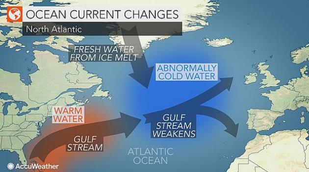
Cold "Blob" in North Atlantic Ocean May Affect Weather in Europe, Eastern U.S.
Is rapid melting of Greenland and a subsequent flush of fresh water
into the North Atlantic impacting weather patterns? Here's an excerpt
from a story at
AccuWeather: "...
According
to According to AccuWeather Chief Meteorologist Elliot Abrams, "If the
Gulf Stream and correspondingly other currents in the Atlantic weaken,
then it could change long-term temperature patterns all around the
Atlantic basin." Some scientists believe that prior temperature
anomalies have already begun to alter and slow the Gulf Stream and the balance of the currents
circulating through the Atlantic over the past 100 years or so. The
temperature of surface ocean water can vastly affect the temperature of
nearby land areas..."
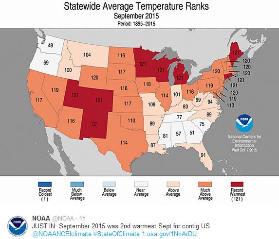
Balmy September For Most of USA.
Parts of the Deep South and Pacific Northwest saw September
temperatures close to average, no cooler than average weather in the
Lower 48. The most pronounced warmth was observed from the Rockies and
Upper Midwest into parts of New England. Source: NOAA.
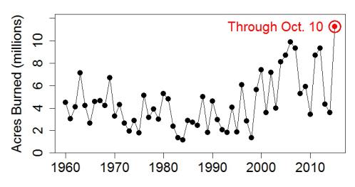
2015: Most Wildfire Acres Burned in USA - Year To Date.
Perpetual drought and record heat has taken a toll, and it appears that
this year has the dubious distinction of the most acres burned in the
historical record. Here's an excerpt at
tamino.wordpress.com: "...
Those
black dots are yearly totals — the red one, circled, is only the year
so far. With nearly three months to go, and October a traditionally bad
fire month for California … how much worse will it get?..."
Sunshine Skyway Bridge Waterspout Video Shows Florida Tornado Flipping a U.S. Mail Truck. If you're expecting a package from Florida it may show up - via air mail. Here's an excerpt and video link from
Inquisitr: "...
In
Florida, a video of the Sunshine Skyway Bridge’s waterspout touchdown
has gone viral since it shows a U.S. mail truck sent tumbling twice end
over end after the water twister hit the tractor trailer. Fortunately,
the driver of the vehicle was perfectly fine after suffering suffering
through the Florida waterspout, and now the driver has a crazy tale to
tell everyone..."
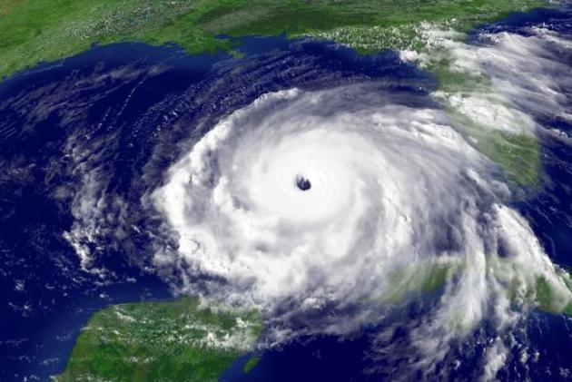
Tampa Bay Rated Nation's Most Vulnerable to Hurricane Storm Surge. Thinking about a place in the Tampa area? Cheap advice: rent, don't buy. Here's an excerpt from
The Tampa Bay Times: "
With
$175 billion in potential losses, Tampa Bay is the most vulnerable
metro area in the nation to storm surge floods caused by a
once-in-a-century hurricane.That's the conclusion from a recent study by
Karen Clark & Co. (KCC), a Boston-based firm that specializes in
modeling the likely property damage and losses from windstorms,
earthquakes and other catastrophes for the insurance industry. Analysts
estimate Tampa could suffer higher losses than New Orleans or New York
City, the next two most vulnerable cities on the KCC list..."
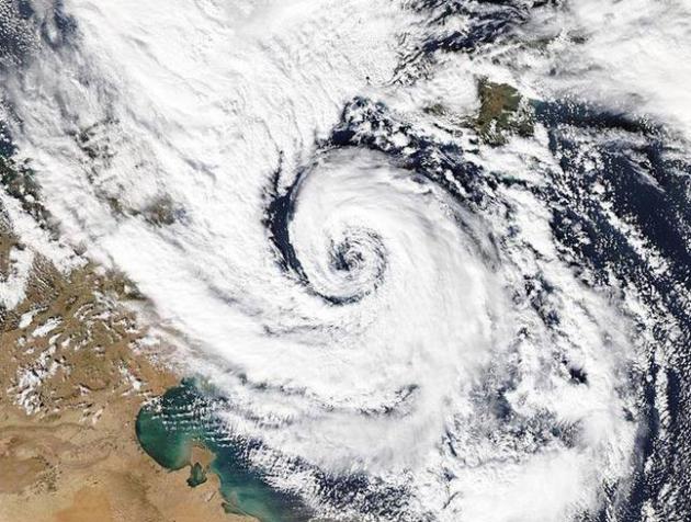
The Storm That Ravaged French Riviera.
Could a hurricane spin up in a (warming) Mediterranean Sea?
Tropical-storm like cyclones have spun up in the past, a hybrid weather
phenomena dubbed a
Medicane. Expect the unexpected. Here's an excerpt from
Gulf Times: "...
To
set off this chain of events, the ocean’s surface temperature has to be
above 26C (79F), but in the Mediterranean the storms are slightly
different. ‘Medicanes’ have been known to develop even when the sea is
significantly cooler. This has prompted some meteorologists to question
whether the storms really are hurricanes. Hurricanes that try to develop
in the Mediterranean are also limited by space. If you compared the
size of the Mediterranean to the Atlantic or the Pacific Ocean, then
clearly it is tiny. It also has a large number of islands and peninsulas
jutting into it. This means that it is difficult for a storm to spend a
significant time over water, as would be necessary for a powerful
hurricane to develop. However, despite this, occasionally hurricane-type
systems have been spotted in the Mediterranean. They usually originate
from other ‘regular’ storms, which then begin to feed off the warm
waters of the Mediterranean and begin to take on the characteristics of a
hurricane..." (November 7, 2014 file:
wunderground.com)
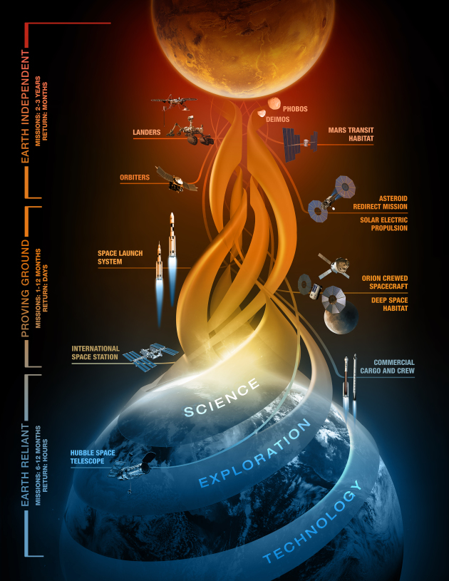
NASA Releases Plan Outlining Next Steps in Journey to Mars.
I hope I live long enough to see an American flag planted on the
surface of Mars. It may come faster than you think - here's an excerpt
from
NASA: "
NASA
is leading our nation and the world on a journey to Mars, and Thursday
the agency released a detailed outline of that plan in its report,
“NASA’s Journey to Mars: Pioneering Next Steps in Space Exploration.”
“NASA is closer to sending American astronauts to Mars than at any point
in our history,” said NASA Administrator Charles Bolden. “Today, we are
publishing additional details about our journey to Mars plan and how we
are aligning all of our work in support of this goal. In the coming
weeks, I look forward to continuing to discuss the details of our plan
with members of Congress, as well as our commercial and our
international and partners, many of whom will be attending the
International Astronautical Congress next week...”
Best Places to Travel in 2015.
Travel + Leisure has a few ideas; here's an excerpt: "...
The
world is getting smaller, but the chances of having an extraordinary
new experience are only increasing. We’ve identified 50 standout
destinations, based on industry news and trends, with input from
contributing writers, A-List travel agents, and our new local experts.
These are the places changing the travel map, whether it’s an emerging
arts hub in Germany or a quiet stretch of sand in the Caribbean...."
The Man Who Builds Luxury Bomb Shelters for Paranoid One Percenters. Yes, but will they withstand a tornado? It sure looks like it.
VICE has an eye-opening story; here's an excerpt: "
As we roll down US Highway 41 in Terre Haute, Indiana , my guide insists I give him my iPhone. Then he tosses me a satin blindfold. The terms of our trip were clear—I wasn't to know where we were going or how we got there. That's because we're on our way to the undisclosed location of an underground bunker designed to survive the end of the world, whatever form that apocalypse takes..."
Photo credit above: "
Robert Vicino outside the entrance of Vivos Europa One."
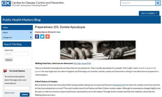
Here's How Much a Zombie Apocalypse Survival Kit Costs. Someone at CDC has a good sense of humor.
Money.com has the details; don't say you weren't warned: "...
In
an effort to promote awareness around disaster preparedness (natural
and otherwise), the Centers for Disease Control put together a zombie apocalypse preparation kit
that details everything you would need to have on hand in the event the
living dead showed up at your front door. The practical suggestions are
not much different from what the agency recommends in the event of a flood, earthquake, or other natural disaster. We took the CDC’s recommendations and a few others from ‘zombie expert’ Max Brooks, author of The Zombie Survival Guide, to price out a fairly simple emergency kit that would have you covered for almost any crisis situation..."
TODAY: Mostly cloudy and blustery, showers up north. Winds: NW 20-45. High: near 60
MONDAY NIGHT: Leftover clouds, cold wind. Low: 41
TUESDAY: Sunny, less wind. Winds: NW 10-15. High: 63
WEDNESDAY: Sunny, a fine fall day. Wake-up: 44. High: 65
THURSDAY: Colder wind, few showers. Wake-up: 49. High: 58
FRIDAY: More clouds than sun, still brisk. Wake-up: 43. High: 54
SATURDAY: Frost outer suburbs? Sunny. Winds: W 5-10. Wake-up: 37. High: 58
SUNDAY: Windy, trending milder with plenty of sunshine. Winds: S 15-25. Wake-up: 39. High: 63
Climate Stories...
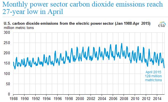
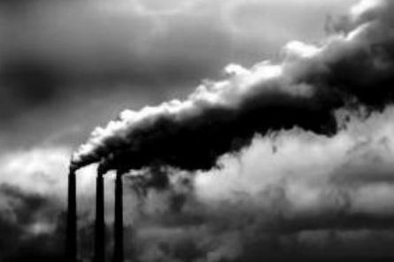
Carbon Emissions from U.S. Power Plants Hit 27-Year Low. The ship is pointed in the right direction, it seems. Here's an excerpt from
Climate Central: "
As
states begin the long task of reducing greenhouse gas emissions from
electric power plants to comply with new federal climate policy, a
27-year low in carbon dioxide emissions earlier this year shows the U.S.
may be heading toward meeting its emissions goals. U.S. power plants
emitted less carbon dioxide — 128 million metric tons — in April than at
any point in since April 1988, according to new U.S. Energy Information Administration data..." (Image credit:
EIA).
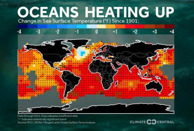
3F Ocean Water Temperature Rise since 1901.
Climate Central has details: "
This
year is on track to be the hottest on record globally. The strong El
Niño is likely playing a role as the average global temperature of an El
Niño year is 0.4°F higher than a La Niña year. However, the strong El
Niño is not solely responsible for the warming planet. Global
temperatures have been trending upward since 1950, regardless of whether
or not the Pacific Ocean was in an El Niño, La Niña, or neutral phase.
In fact, La Niña years in the 21st Century are now warmer than El Niño
years just 30 years ago. Similarly, the long term trend of global ocean
water temperatures is on the increase, emphasizing that El Niño is only
magnifying the ongoing warming trend..."
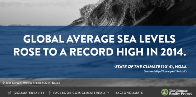
Another Marker.
Warming water expands - nothing controversial about that statement.
Water can't expand downward so it rises, impacting sea level rise. This
is a fairly big deal, considering 40% of the American population lives
in a highly populated coastal area, and 8 of the world's 10 largest
cities are near coastline. Graphic and facts courtesy of
The Climate Reality Project.
Exxon's Climate Concealment. My
late father in law worked for Exxon - he had a PhD in chemical
engineering, had scores of patents and worked on catalysts for
refineries. He died way too early - from cancer, which may have been a
result of the carcinogens he was exposed to. No way to prove it, true,
but he spent much of his time around exotic chemicals - it's not a leap
of logic to think this may have been a factor. I wonder what he would
have thought of Exxon's apparent obfuscation of their own scientist's
research into climate change. Here's an excerpt from
The New York Times: "...
Exxon (which became Exxon Mobil in 1999) was a leader in these campaigns of confusion. In 1989, the company helped to create the Global Climate Coalition
to question the scientific basis for concern about climate change and
prevent the United States from signing on to the international Kyoto
Protocol to control greenhouse gas emissions. The coalition disbanded in
2002, but the disinformation continued. Journalists and scientists have
identified more than 30 different organizations funded by the company
that have worked to undermine the scientific message and prevent policy
action to control greenhouse gas emissions...."
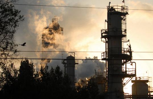
Photo credit above: "
The Exxon Mobile Refinery in Torrance, Calif." Credit Jamie Rector/Bloomberg.
Teaching the Truth About Climate Change. Here's an excerpt of an Op-Ed from the
New York Times Editorial Board: "
Misinformation about climate change is distressingly common in the United States — a 2014 Yale study
found that 35 percent of Americans believe that global warming is
caused mostly by natural phenomena rather than human activity, and 34
percent think there is a lot of disagreement among scientists about
whether global warming is even happening. (In fact, an overwhelming
majority of scientists agree that climate change is here and that it is
caused by humans.) One way to stop the spread of this misinformation is
to teach children about climate change...."
Economist Greenstone Sees Climate Change Accelerating as Developing Countries Rise. Here's an excerpt from The Star Tribune: "...Asking
the Chinese and Indians to hold off on development that improves
people’s lives — especially after a century in which the Western world
pumped out the lion’s share of CO2 emissions — is a non-starter,
Greenstone said. Governments subsidize energy in myriad ways that
confuse and distort the market. Many economists argue that more money
should be spent on research for cheaper green energy. Warming
temperatures will hit countries like India hardest....


No comments:
Post a Comment