Meteorologist Paul Douglas writes about Minnesota weather daily, trying to go beyond the "highs" and "lows" of the weather story to discuss current trends and some of the how's and why's of meteorology. Rarely is our weather dull - every day is a new forecast challenge. Why is the weather doing what it's doing? Is climate change a real concern, and if so, how will my family be affected? Climate is flavoring all weather now, and I'll include links to timely stories that resonate with me.
Tuesday, November 10, 2015
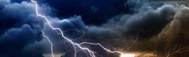
Soaking Rains Tonight as Winds Reach 40 MPH - A Real Cold Front Brewing in 7-10 Days?
61 F. high temperature Tuesday in the Twin Cities. 69 F. record high on November 10, set in 2012. 45 F. average high on November 10. 31 F. high on November 10, 2014.
November 11, 1940:
The Great Armistice Day Blizzard kills 49 people in Minnesota. Food
dropped by Pilot Max Conrad saved stranded hunters. The barometer fell
to 28.66 inches at Duluth. Some roads were so badly blocked with snow
they weren't opened until Nov. 22.
How Weather Forecasting Is Like Fantasy Football Much-Needed Soaking Tonight
So,
how's your fantasy football team doing? (crickets). Not quite working
out the way you thought? Wait, you weren't able to predict injuries or
trades weeks in advance? Welcome to my world.
The physics
that powers our weather models isn't perfect. Neither is the data, the
fuel, that fuels the models. It's a little like putting old gasoline
into a 1968 Dodge; wondering why you can't get good fuel mileage. Junk
in - junk out. The winter forecast for Minnesota depends on El Nino,
snow depth in Siberia, and wobbles in the general circulation we can't
even track today.
A year ago MSP was digging out from over 3 inches of snow. The storm that slushed up the metro November 10-11
dumped a foot on central Minnesota. The first 9 days of November, 2015
were 11.6F warmer than average - more typical of Topeka, Kansas.
1-2 inches of badly needed rain is about to recharge soil moisture; the heaviest rains come tonight. By time time it's cold enough to snow the moisture will be gone; a few flakes on Thursday, a dull reminder that it's mid-November.
I'm betting on a pale-green Thanksiving.
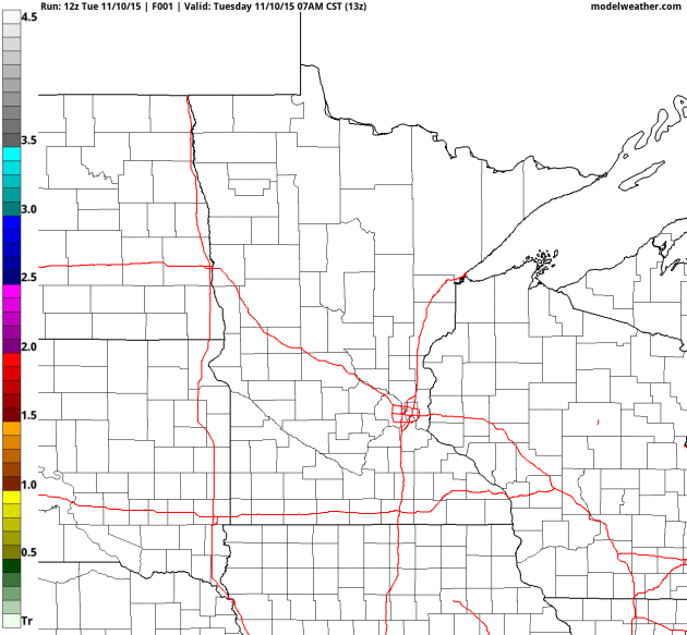
Heaviest Rain Bands Just South and East of MSP?
Here is the 4 KM NAM solution, showing a half inch for the west metro,
closer to 1 to 1.5" for St. Paul, with as much as 2 to 2.5" of rain
forecast closer to Hastings and Red Wing, most of that falling tonight.
Source: NOAA and AerisWeather.
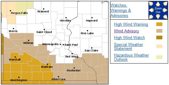
High
Wind Warning Southwestern Minnesota. Winds will be howling late tonight
and early Thursday, with the strongest winds south and west of MSP.
Details from the Twin Cities National Weather Service:
...POWERFUL STORM SYSTEM TO BRING HIGH WINDS TO SOUTHERN MINNESOTA...

.A HIGH WIND WARNING HAS BEEN ISSUED FOR A PORTION OF SOUTHWEST
AND SOUTH CENTRAL MINNESOTA FOR WEDNESDAY NIGHT DUE TO STRONG
WINDS DEVELOPING IN THE WAKE OF A POWERFUL STORM SYSTEM. SUSTAINED
WINDS OF 35 TO 40 MPH WITH GUSTS NEAR 60 MPH WILL BE POSSIBLE IN
THE WARNING AREA. THE HIGH WIND WARNING IS LOCATED SOUTHWEST OF A
LINE FROM REDWOOD FALLS TO MANKATO...AND THEN SOUTH TO THE IOWA
BORDER.

STRONG WINDS WILL ALSO DEVELOP OVER MUCH OF SOUTHERN MINNESOTA
LATE WEDNESDAY NIGHT AND CONTINUING THROUGH THE DAY THURSDAY.
SUSTAINED WINDS OF 30 TO 35 MPH WITH GUSTS AROUND 45 MPH WILL BE
POSSIBLE. A WIND ADVISORY HAS BEEN ISSUED AND IS LOCATED MAINLY
SOUTH OF A LINE FROM WILLMAR...LE CENTER AND OWATONNA.

THIS POWERFUL STORM SYSTEM WILL DEVELOP IN THE PLAINS LATE
TONIGHT AND DEEPEN RAPIDLY ACROSS IOWA AND INTO WISCONSIN THROUGH
WEDNESDAY NIGHT.

THE POTENTIAL IMPACTS INCLUDE...LOOSE OBJECTS THAT CAN BE EASILY
BLOWN ABOUT BY THE STRONG WINDS AND SOME LIGHT STRUCTURAL DAMAGE.
PLUS...SOME COMMERCIAL POWER INTERRUPTION WILL ALSO BE POSSIBLE
DUE TO DOWNED POWER LINES.
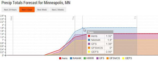
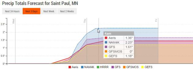
Heavier Rains East of the Mississippi River.
We talk about the "Twin Cities" as one, giant, amorphous blob, but
there can be big variations, just across the metropolitan area. Some of
the models print out .2 to .5" more rain for downtown St. Paul than
downtown Minneapolis. 12 miles doesn't sound like much, but even in a
rain storm there can be big variations over relatively small distances.
Source: Aeris Enterprise.
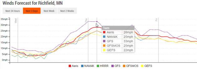
Window-Rattling Winds.
It may sound a little like Tropical Storm Bubba out there tonight, with
windswept rain, falling heavily at times, and sustained winds forecast
to peak between 26 and 33 mph during the wee hours of the morning
Thursday. Expect gusts over 40 mph, enough to make the house shudder and
groan.
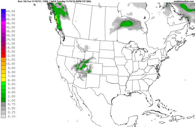
Snow Lovers Just Woke Up.
No, I don't see accumulating snow for the metro area, not yet, but
NOAA's GFS model shows a smear of wet snow late next week over parts of
central and northern Minnesota. I wouldn't schedule a play-date with
your favorite snowmobile just yet - let's see what future model runs
show.
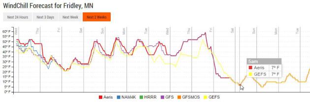
Over a Cliff?
When it's this nice, for this long, I start to get nervous. Previous
model runs have shown big drops in temperature (which never quite
materialized) so I'm still skeptical, but at some point the other shoe
(boot) will drop. GFS guidance shows a wind chill of 7F by 5 am
Saturday, November 21.
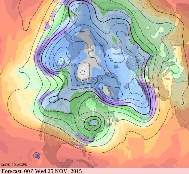
Still Not Persistently Polar.
Peering into my (dirty) crystal ball, looking 2 weeks into the future,
GFS guidance shows a big cut-off low at 500 mb north of New England, but
a persistent Pacific flow for much of the lower 48 states; Minnesota's
winds aloft blowing from the Bay Area, not northern Canada.
AerisWeather Briefings: Issued Tuesday evening, November 10, 2015.
*
Significant severe storm scenario brewing for Midwest Wednesday
afternoon and evening hours; primary risk is violent straight-line winds
over 70 mph in a few cases. Isolated tornadoes can't be ruled out.
*
Band of heavy rain north and west of the severe threat may create minor
urban flooding issues late Wednesday into early Thursday.
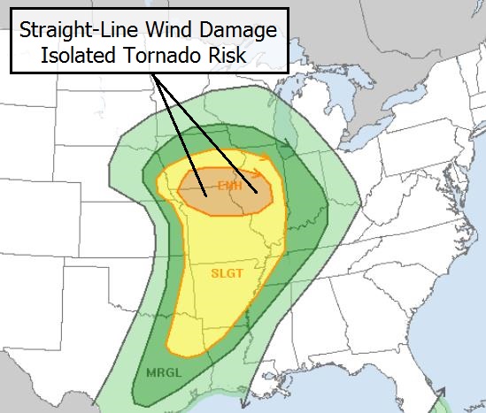
Enhanced Risk.
NOAA SPC has outlined the area that is under the gun, which includes
Springfield, Peoria, Decatur, Bloomington and Des Moines. The enhanced
risk (which implies a high threat of violent thunderstorm winds and
large 2"+ hail) includes northern Missouri, western and central Illinois
and southern Iowa. I do expect watches and warnings by the PM hours
tomorrow. Map: NOAA SPC.
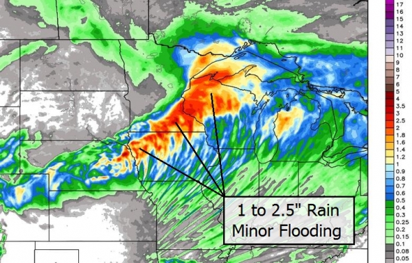
Smear of Heavy Rain.
High-resolution models print out 1-2" rains from near Sioux City to
Mankato, the Twin Cities, Eau Claire and Superior, Wisconsin, with a few
isolated 2-3" amounts. The result will be minor urban flooding -
especially Wednesday night, when the heaviest rains are forecast to
fall. Map credit: WeatherBell.
The pattern is becoming more
volatile, and models show much of the central and eastern USA pushing
into a colder, stormier pattern over the next 7-10 days - capable of
spinning up more significant rain and snow storms. We'll keep you
posted.
Paul Douglas
Senior Meteorologist, AerisWeather
The Norwegian Secret to Enjoying a Long Winter. It's all in your mind. If you tell yourself you're miserable - you will be. Here's an excerpt of a (helpful) article at Fast Company: "...This
is easy enough to change; simply refuse to participate in the Misery
Olympics. Talk about how the cold gives you a chance to drink tea or hot
chocolate all day. Talk about ice skating, or building snowmen. Bundle
up and go for a walk outside, knowing that you’ll likely feel warmer and
happier after a few minutes. Better yet, go with a friend. Social plans
are a great reason to haul yourself out from under the covers. But
overall, mindset research is increasingly finding that it doesn’t take much
to shift one’s thinking. "It doesn’t have to be this huge complicated
thing," says Leibowitz. "You can just consciously try to have a positive
wintertime mindset and that might be enough to induce it."
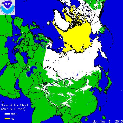
Record Siberian Snow Could Bode Ill for Northeast.
Is there a teleconnection between early (heavy) snows in Siberia and
the potential for major storms, weeks later, downwind - especially Mid
Atlantic and New England? Here's an excerpt from USA TODAY: "There
is a theory about snow in Siberia during the month of October: If there
is a lot, it can mean a particularly wicked winter in the northeast
United States. Last month, Siberia experienced record snowfall and the worst blizzard in a decade.
Above-average snow cover in Siberia is believed to affect the
now-famous polar vortex and send bitterly cold temperatures to the
Northeast. This happens when the Arctic Oscillation, a climate pattern, shifts..."
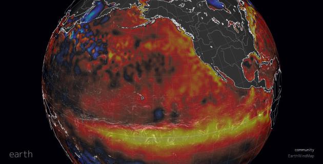
Complicated Tangle of Factors Raising Temperatures in Pacific Ocean. The Columbus Dispatch
has an interesting article that outlines the myriad of factors leading
to record warmth for portions of the Pacific Ocean; here's an excerpt:
"...At the moment, the world’s largest ocean is a troublesome place,
creating storms and causing problems for people and marine life across
the Pacific Rim and beyond. A partial list includes the strong El Nino
system that has formed along the equator, and another unusually
persistent zone of warm water that has been sitting off the North
American coast, wryly called “the Blob.” And a longer-term cycle of
heating and cooling known as the Pacific Decadal Oscillation may be
switching from a cooling phase to a warming phase. On top of all that is
the grinding progress of climate change, caused by accumulation of
greenhouse gases generated by human activity..."
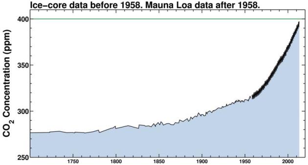
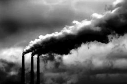
Greenhouse Gases Hit New Milestone, Fueling Worries About Climate Change. Here's a clip from The Washington Post: "...The
World Meteorological Organization, in an annual accounting of
greenhouse gas concentrations in the atmosphere, reported that average
levels of carbon dioxide exceeded 400 parts per million in the early
months of 2015, a rise of 43 percent over pre-industrial levels. And, in
a separate report hours later, the Met Office and Climatic Research
Unit at Britain’s University of East Anglia reported that the Earth’s
average temperature has crossed the symbolically important 1-degree C
(1.8 F) mark, with temperatures over the first nine months of the year
exceeding historic norms by exactly 1.02 degrees C..."
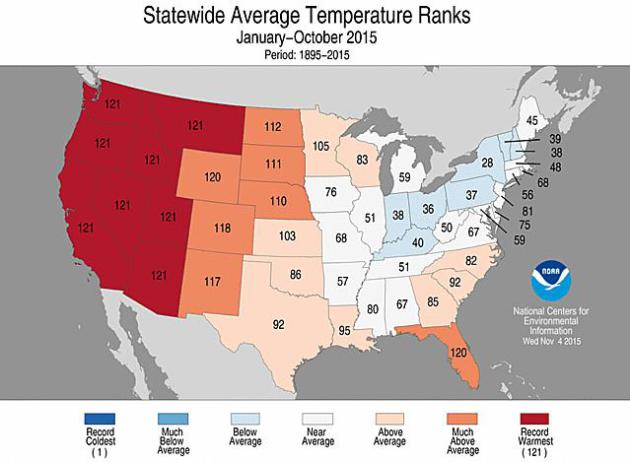
8 Western States Have Warmest Year So Far.
Based on NOAA NCDC data it appears Minnesota is experiencing the 16th
warmest year, to date, in the last 121 years. Here's an excerpt from Climate Central: "For eight western U.S. states, this has been the warmest year on record through October, according to new temperature data
released Friday, and several of those states are likely to continue
that record to year’s end. The Lower 48 as a whole is also trending hot,
and could see the year end up among the 10 warmest in more than 120
years of records. “I think that it is more likely than not that we will
see a Top 10 warm year for the contiguous United States,” Jake Crouch, a
National Oceanic and Atmospheric Administration climate scientist, said in an email..."
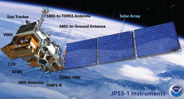
Map credit above: "Where temperatures for each state ranked for the period from January to October 2015." Credit: NOAA. On Weather Satellites, Congressional Outlook Should Not be Clouded.
Yes, keeping a fleet of operational weather satellites is optimal - if
they begin to blink out we'll be flying blind. Here's an excerpt from TheHill: "...Congress'
reluctance to fund these programs could have catastrophic consequences.
For instance, the JPSS and Polar Follow-On satellites promise to shrink
a storm's "cone of uncertainty" -- in other words, where and when a
storm will strike -- by up to 75 percent when compared to weather
forecasting systems without this technology. If the JPSS/PFO system had
been online during 2005's Hurricane Rita, projections about the storm's
path could have been narrowed by roughly 875 miles. This, in turn, would
have made the evacuation effort far more effective and less costly, and
non-impact areas could have maintained normal operations..." (Image credit: NOAA).
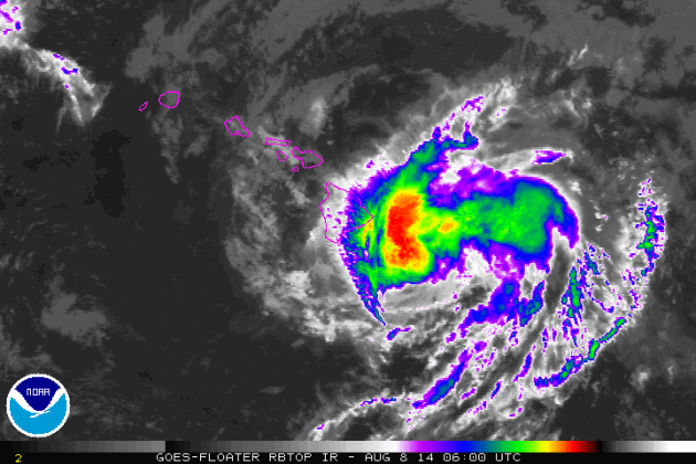
Flurry of Hawaiian Hurricanes Shows Climate Fingerprints.
Paradise may be within striking distance of more numerous and intense
hurricanes in the years to come as the Pacific continues to warm and
patterns shift northward. Here's an excerpt from Climate Central: "...The
research, published in the Bulletin of the American Meteorological
Society’s annual attribution report, specifically links the three 2014
storms that came within striking distance of the island chain
— including Iselle, which grazed the Big Island as a tropical storm — to
climate change. This year’s nine hurricanes in the central Pacific
are also reinforcing the idea that climate change could mean more
active hurricane seasons around Hawaii in the future. Hawaii has a quiet
history of hurricanes, in part because it’s surrounded by relatively
cool water that acts as a moat keeping most strong storms out or
weakening them before they make landfall. Wind patterns also tend to
steer storms away or tear them apart..."
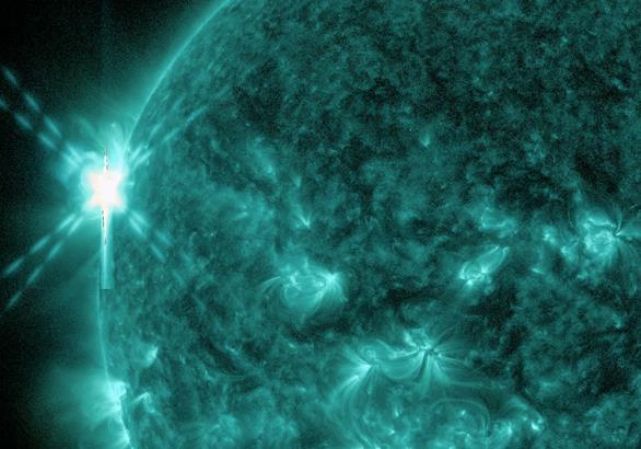
File Image credit above: "Satellite imagery of Iselle as it approaches the Big Island as a tropical storm in August 2014." Credit: NOAA When The Sun Went Medieval on our Planet.
Let's pray it doesn't happen again anytime soon - but it might not be a
bad idea to adopt the motto of the Boy Scouts and be prepared (for
anything). Here's an excerpt at Slate: "...We’ve known for a long time that the Sun is capable of producing huge magnetic explosions. In 2003 it let rip a series of solar storms so powerful that one of them set the record for the biggest flare seen in modern times. And the strongest known was also very first solar explosion ever seen — called the Carrington Event,
after an astronomer who studied it — happened in 1859. It created
aurora as far south as Mexico and Hawaii! Events like that can also
create what are called geomagnetically induced currents (GICs): The
Earth’s magnetic field shakes so violently that it induces currents in
conductors on the ground. Telegraph operators reported
being able to send messages even though the power was disconnected;
enough electricity was flowing through the lines to work the devices..."
Image credit above: "An
example of a powerful flare erupting on the Sun (from May 5, 2015). The
NASA satellite SDO is one of many assets used to monitor solar activity." Photo by NASA/GSFC/SDO.
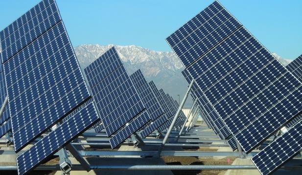
This Could Be The Biggest Sign Yet That The Battery Revolution Is Here. Energy storage is being implemented at large (utility) scale in California; here's an excerpt from The Washington Post: "...Bringing
large batteries into this mix will allow the agency to pay less in
so-called “demand charges,” which are assessed based on peak levels of
electricity usage, says general manager Joseph Grindstaff, by powering
up batteries from the solar panels or other sources and then drawing
them down again at opportune times..."
Photo credit above: "The
California Inland Empire Utility Agency’s solar panels, located at
three of the Agency’s recycled water facilities and IERCF, generate 3.5
MW of clean solar power and will reduce electrical costs at its
facilities — the single largest component of IEUA’s operating budget.
The solar project is funded in part under the State’s Innovative
California Solar Initiative." (Inland Empire Utilities Agency/John Mellin).
Nothing Can Compete With Renewable Energy, Says Top Climate Scientist. The Guardian has the interview; here's a clip: "...In July, Schellnhuber told a science conference in Paris
that the world needed “an induced implosion of the carbon economy over
the next 20-30 years. Otherwise we have no chance of avoiding dangerous,
perhaps disastrous, climate change.” “The avalanche will start because
ultimately nothing can compete with renewables,” he told the Guardian.
“If you invest at [large] scale, inevitably we will end up with much
cheaper, much more reliable, much safer technologies in the energy
system: wind, solar, biomass, tidal, hydropower. It is really a
no-brainer, if you take away all the ideological debris and lobbying...”
File photo credit above: "Climate scientist, Prof John Schellnhuber, has advised Angela Merkel and Pope Francis." Photograph: Patrick Pleul/Corbis.
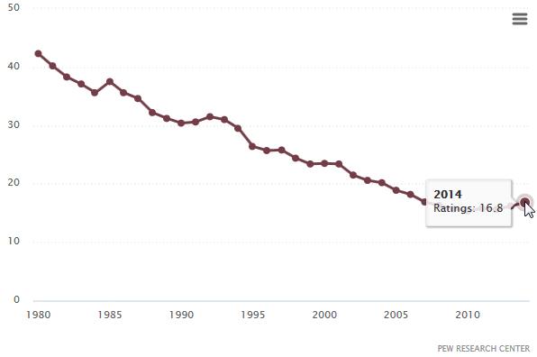
Netflix Boss Blasts The Evening News.
Will our kids and grandkids be watching news at a fixed schedule? I
hope so, but others have their doubts. Here's an excerpt from The New York Post: "...No,
the outspoken Hastings replied, adding: “The 6 p.m. newscast: that
thing’s going away.” Well, that might have been news to any of the
networks. The big three evening news broadcasts — on ABC, CBS and NBC —
actually grew their audience in 2014, growing 5 percent, to 24 million
viewers, from 2013, according to Pew Research Center. It’s unclear if
Hastings was referring to the national broadcast news programs which
typically air at 6:30 p.m., or the local evening news which usually airs
in the preceding half hour. A spokesman for Netflix later clarified
that Hastings was referring to any news broadcast at a fixed hour..."
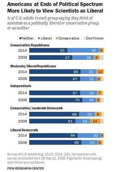
Graphic credit above: Pew Research Center, journalism.org. "November-to-November average rating per night for all three networks (NBC, CBS, ABC)". Nielson Media Research.
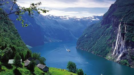
The World's Best and Worst Place to Live Are... Go Norway! Here's an excerpt from CNN.com: "For
the seventh consecutive year, Norway topped the list as the most
prosperous country in the world. It scored the highest in many variables
including "trust in others," "satisfaction with freedom of choice,"
"civil liberty and free choice" and "satisfaction with standard of
living." Denmark and Sweden came third and fifth. Finland and Iceland
ranked ninth and 12th on the list. On the flip side, the research
company says that the Nordics still have some catching up to do.
Economy-wise, they haven't been doing as well as many other advanced
countries..."
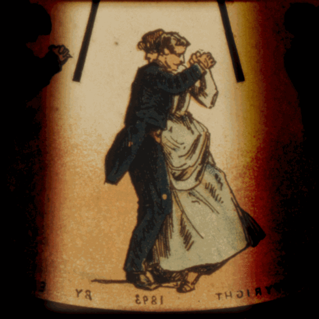
The Forgotten Kaleidoscope Craze in Victorian England.
Pretty amazing - drawing a convincing link between kaleidoscopes and
iPhones, how we adapt to new technology and how this impacts our
interactions with each other and the world. Here's a clip from Atlas Obscura: "...Each
time a new mobile technology is introduced to a culture, it redefines
our understanding of what it means to be a social person in the world.
Devices like the kaleidoscope and our iPhones are symbols of this shift.
Right now, there is a lot of investment in getting us to put down our
devices and experience “authentic” human connection..."
Image credit above: "Another popular 19th century optical device, a Phenakistoscope, in action." (Photo: JBarta/WikiCommons CC BY-SA 2.5).
This Man is Walking Across Antarctica All Alone. He must have pissed someone off. Wow. Here's an excerpt at National Geographic: "As
summer dawns in the Southern Hemisphere, a seasoned Antarctic explorer
is hoping to add his name to the Polar record books on the centennial of
Sir Ernest Shackleton’s ill-fated Endurance Expedition. Henry Worsley,
a 55-year-old British ex-army officer, is endeavoring to become the
first person to cross the Antarctic continent alone, unsupported, and
unassisted..."
Photo credit above: "British polar explorer Henry Worsley hopes to complete the first unassisted, unsupported, solo traverse of the continent." Photo: Henry Worsley.
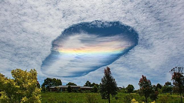
Remarkable "Fall-Streak Hole" Appears in Skies Over Australia. Check this out, courtesy of The Australian: "...In
the right conditions, a trigger can cause some of those supercooled
droplets to freeze, and set off a similar chain reaction. The result is a
“fallstreak hole”, pictured in a shot from the Bureau of Meteorology’s
2016 calendar (on sale now). And the trigger? It’s an aircraft. As the
plane punches through the cloud, it seeds the first ice crystals and
sets the whole thing in motion. As the crystals grow they literally drop
out of the cloud (falling crystals are causing the rainbow effect in
this shot). Circulating air currents around the edge of the hole feed
into the chain reaction. Within an hour a fallstreak hole can grow to
50km across..."
Image credit above: "Weird: the fallstreak hole over Korumburra, Victoria." Picture: David BartonSource: News Corp Australia.
TODAY: Rain develops by afternoon. Winds: E 10-15. High: 54
WEDNESDAY NIGHT: Rain, heavy at times. Winds gust to 40+ mph. Low: 40
FRIDAY: More clouds than sun, brisk. Winds: NW 10-20. Wake-up: 33. High: 42
SATURDAY: More sun, a good leaf-raking day. Winds: S 10-15. Wake-up: 31. High: 54
SUNDAY: Mild sun, feels like early October. Winds: S 8-13. Wake-up: 40. High: 58
MONDAY: Still mild, PM showers possible. Wake-up: 43. High: 53
TUESDAY: Periods of rain - cooling off. Wake-up: 46. High: 49 (falling)
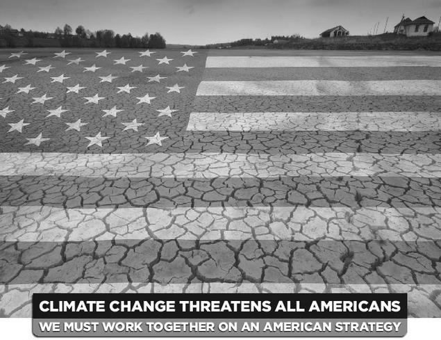
Climate Stories...
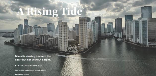
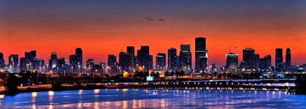
A Rising Tide. New Republic explains how Miami is sinking beneath the sea - but no without a fight. Here's an excerpt: "...And Miami Beach is just one small part of a region that’s in big trouble. If sea levels rise as projected,
no major U.S. metropolitan area stands to rack up bigger losses than
Miami-Dade County. Almost 60 percent of the county is less than six feet
above sea level. Even before swelling of the seas is factored in, Miami
has the greatest total value of assets exposed to flooding of any city
in the world: more than $400 billion. Once you account for future
sea-level rise and continued economic growth, Miami’s exposed property
will far outstrip that of any other urban area, reaching almost $3.5
trillion by the 2070s..."
Can Miami Beach Survive Global Warming?Vanity Fair provides more perspective; here's an excerpt: "Compounding
the city’s vulnerability to major weather events is the worldwide
phenomenon of sea-level rise. Due to thermal expansion of the oceans and
the melting of ice sheets and glaciers in the Earth’s far latitudes,
the global mean sea level is rising. How fast and how much is a matter
of debate, with such federal agencies as the U.S. Army Corps of
Engineers, NASA, and the National Oceanic and Atmospheric Administration
projecting, on the low end, eight inches of sea-level rise by the year
2100, and, on the high end, as much as six feet.
But Miami Beach, a low-lying city to begin with, is already feeling the
effects of sea-level rise. Every time there’s a heavy rain, the locals
brace for flooding on Alton Road, the main north-south thoroughfare of
the city’s west side, as well as on smaller roads in the area, such as
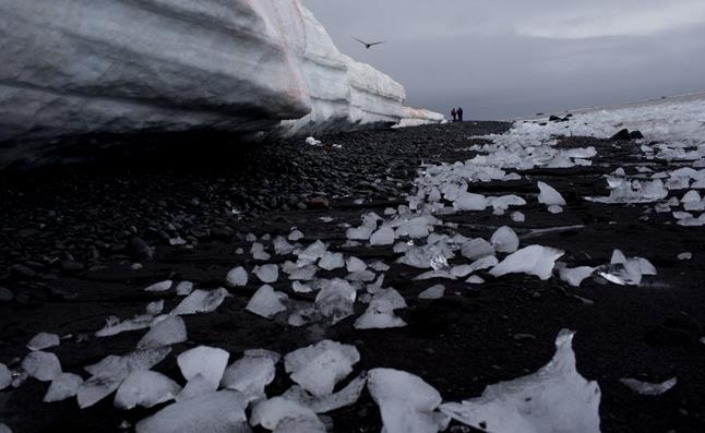
Purdy Avenue, where Levine filmed his commercial..." 3 Lessons From That Antarctic Ice Study. Measuring Antarctic ice isn't easy, as this article at Christian Science Monitor highlights; here's an excerpt: "...Scientists
agree that none of the data-gathering tools are perfect. What they
don’t agree on is which measurement tool – GRACE or ICESat – provides
the most accurate data. “You’re talking about a continental-size area
and changes in centimeters and millimeters,” explains Thomas P. Wagner, a
NASA climate scientist, in an interview with the Monitor. “It’s very,
very difficult to do this from space with a satellite, but one of the
only ways to do it is by satellite,” he explains. But scientists are
constantly improving their tools and learning more about the ice
sheets..."
Photo credit above: "In this Jan. 26,
2015 photo, pieces of thawing ice are scattered along the beachshore at
Punta Hanna, Livingston Island, South Shetland Island archipelago,
Antarctica. Water is eating away at the Antarctic ice, melting it where
it hits the oceans. As the ice sheets slowly thaw, water pours into the
sea, 130 billion tons of ice (118 billion metric tons) per year for the
past decade, according to NASA satellite calculations." (AP Photo/Natacha Pisarenko)
Why Can't Republicans Support a Carbon Tax? Here's an excerpt from The New Yorker that caught my eye: "...The E.U., New Zealand, Quebec, Tokyo, and parts of China (which plans to nationalize its carbon-pricing markets, in 2017),
along with others, use a cap-and-trade system. British Columbia, Costa
Rica, France, Japan, and the U.K., among other countries and regions,
charge a fee or tax based on a unit of use, like that in the
Whitehouse-Schatz pricing proposal. And a number of high-profile
coalitions, including investment banks, oil companies, and heads of state,
have formally requested that the international community price carbon.
“In the context of international negotiations, there will be more and
more pressure on the U.S. not to lead but just to catch up,” Aldy told
me..."
Following The Law Isn't Exxon's Only Obligation. Here's a clip of an Op-Ed at Bloomberg View: "...The
same principle requires companies to stay within the bounds of probity
in discussing external factors that bear on the company’s prospects,
such as coming regulatory requirements and relevant technological shifts
-- and climate change. If a company is perceived to have misled the
public, its economic prospects will suffer, and it will struggle
mightily to show that it has served its shareholders. Finally, large
corporations have social and political influence, and for that reason
they have ethical obligations to the public as a whole..." (File photo: Jessica Rinaldi).
No, Climate Change Skepticism Isn't Really About Doubting Science. It's about the lingering confusion over the consensus. That 97-number keeps popping up. Here's a snippet from The Washington Post: "...So
there's a big gap in Americans' understanding of the scientific
community's consensus and the scientific community's actual consensus on
climate change. Dana Nuccitelli, one of the authors of that 2013
review, thinks that misunderstanding correlates directly with Americans'
belief in what causes climate change: If the scientists we trust are
apparently unsure of whether climate change is happening, then why
should we be? Of course, that's not the case among the scientific
community..." Climate Change is the "Mother of All Risk" to National Security. Here's an excerpt of an Op-Ed written by an Iraq war veteran and former Special Advisor to the U.S. Army on Energy at TIME: "...One of the U.S. military’s less-noticed findings, however, is that there is clear consensus
that climate change poses an immediate risk to national security.
Military leaders recognize that they must lead by example and address
the threat of climate change, and they are actively pushing goals
to dramatically scale up renewable energy. The U.S. must replicate this
leadership and seize the opportunity when countries meet this December
in Paris to finalize a global deal on climate change..."
To the military, climate change acts as a threat multiplier, exacerbating threats in already unstable regions of the world.
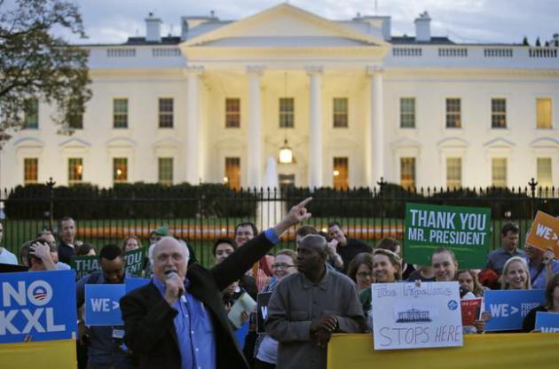
Bill McKibbon on Keystone XL Rejection: "The Tide is Starting to Turn". Here's an excerpt of an interview at RollingStone: "...With
the fight over Keystone finally over, McKibben reflected on its start:
the moment he heard NASA's leading climate scientist, Jim Hansen, say
that if the pipeline went through, and the world burnt through the oil
located in the Alberta tar sands, it would be "game over" for the
planet. "That was the
first time for me, and I think for most people, there was this sudden
realization that there were profound limits to business as usual, and we
had run into them. And that's the message that, in the end, carried the
day," McKibben says. "From Jim Hansen's lips to President Obama's ears —
though it took four very long and difficult and magnificent years to
get there..."
Photo credit above: "Gene
Karpinski, left with microphone, president of the League of
Conversation Voters, speaks during a gathering in front of the White
House to celebrate President Barack Obama's rejection of the proposed
Keystone XL pipeline Friday, Nov. 6, 2015, in Washington." (AP Photo/Alex Brandon)
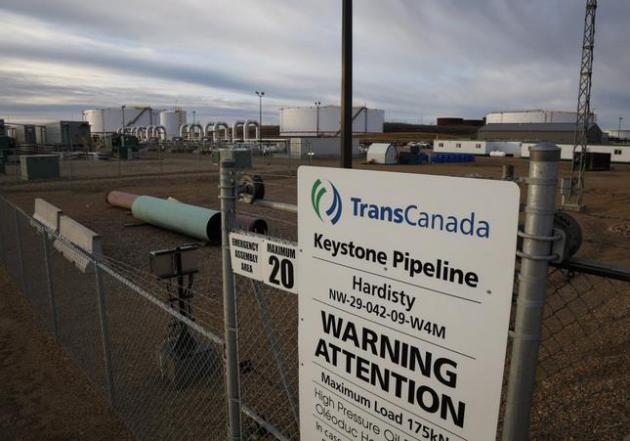
What Critics of the Keystone Campaign Misunderstand About Climate Activism. Here's an excerpt of a Dave Roberts article at Vox that helped me frame the Keystone decision in a much larger context: "...That's
because Keystone was about more than climate; it was also about local
pollution, political corruption, and corporate bullying. This helps
explain why climate activism has primarily manifested as "Blockadia" —
blocking and shutting down bad projects is easier to organize around
than efficiency or carbon pricing. And maybe that's fine. Maybe it isn't
the role of activists to imagine and bring about a new world. Maybe
that's for policymakers, designers, engineers, artists, and
entrepreneurs. Maybe the highest and best use of activism is just to
make things uncomfortable, and more expensive, for the bad actors
benefiting from the unsustainable status quo..."
Photo credit above: "A
sign is posted in front of TransCanada's Keystone pipeline facilities
in Hardisty, Alberta, Canada, on Friday, Nov. 6, 2015. Following the
Obama administration’s rejection of the Keystone XL pipeline, the oil
industry faces the tricky task of making sure the crude oil targeted for
the pipeline still gets where it needs to go." (Jeff McIntosh/The Canadian Press via AP).
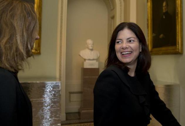
Kelly Ayotte and the Rise of Green Republicans. Here's another hopeful sign; highlighted in a story at New Republic: "There’s a powerful moment occurring on climate change right now in the GOP. As Greg Sargent writes in our latest issue, the party's solid wall of science-denial has begun to crack. In September, eleven House Republicans signed
a resolution calling climate change a manmade problem that must be
fixed. Then, last Thursday, in another sign of the shift, four
senators—Kelly Ayotte, Mark Kirk, Lamar Alexander, and Lindsey Graham—announced their own energy and environment working group. So
far, this is a trickle, not a flood, and it doesn’t mean the larger GOP
will soon come around to a sensible climate platform. But it does say
something hopeful about the state of America's climate politics..."
File photo: AP Photo/Carolyn Kaster.
Lamar Smith vs. NOAA.
Due diligence or blatant harrassment of scientists trying to do their
jobs and incorporate new (refined) data sets? Here's an excerpt at Medium: "...NOAA
is right to resist, and the press is wrong to back burner this
grotesque mockery of congressional oversight. The press will most likely
cower indecently rather than tell the truth here, as they have done so
much lately. It’s another chapter in the fake scandal horror show, and
they’ll dutifully report “both sides”. Smith is being flagrantly and
transparently abusive, and it would be good if the rest of society did
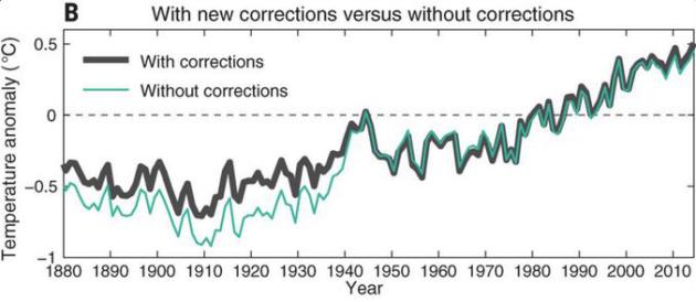
not turn away.The image embedded in my tweet shown
displays the original and updated NOAA NCEI global mean surface
temperature. What I’d like you to take away from it is that the
corrections are tiny, and that if anything the observed global warming
is made smaller. The adjustments to the “hiatus” 1998–2013 period are
almost invisible, and it is this which is driving the congressional
witch hunt."


No comments:
Post a Comment