Mild December Weather Continues - Weekend Snow?
By Todd Nelson, filling in for Douglas.
My shovel feels neglected. I know this for a fact because it has been staring at me longingly from the corner of the garage for weeks now. I am not sure what to tell it other than I am sure it'll snow at some point this winter. Trust me, I'm a weatherman.
Other than a couple of rough commutes, we've been sliding through the snow season relatively easy so far. Minneapolis is running nearly 8 inches below average snowfall so far this season, Duluth nearly 10 inches below average and International Falls nearly 16 inches below average.
No surprise though as Minneapolis recently saw their 4th warmest November in recorded history and is already more than 10 degrees above average this month. International Falls is nearly 18 degrees above average this month, making it the warmest start to a December in recorded history!
Much warmer than average temps continue through the week with a little light rain possible Thursday. Temperatures begin to cool this weekend as a storm system approaches. It may even be cold enough for some snow! Stay tuned
_________________________
TUESDAY NIGHT: Spotty shower possible early, then gradual clearing. Low: 34. Winds: SSE 5-10.
WEDNESDAY: More sun, more vague hints of spring. Winds: SW 8-13. High: 45
WEDNESDAY NIGHT: Mostly cloudy. Winds: S 5-10. Low: 38.
THURSDAY: Breezy. A few light rain showers with a wintry mix north. Winds: WSW 15-25. High: 44
FRIDAY: Mostly cloudy, still feels like mid November Winds: ENE 5-10. Wake-up: 31. High: 42.
SATURDAY: Light mix possible. Slushy up north? Winds: NNE 10-15. Wake-up: 33. High: 39
SUNDAY: Rain changes to wet snow accumulations. Winds: NW 10-20. Wake-up: 29. High: 36
MONDAY: Lingering clouds, cool breeze. Wake-up: 25. High: 31
TUESDAY: Chance of light snow. Wake-up: 20. High: 29.
_________________________
This Day in Weather History
December 9th
2003: Significant snow with amounts between 6 to 10 inches falls from southwest Minnesota across the Minneapolis-St. Paul area and into west central Wisconsin. Winds across the area were 25 to 30 mph, with blowing and drifting snow in open areas. Although some parts of far south central Minnesota only picked up 4 to 6 inches, winds in this area were a little stronger, creating near-blizzard conditions. The greatest snowfall totals occurred in the Twin Cities metro, where Chaska, Chanhassen and New Hope all picked up 11 inches. Ten inches were recorded at Lamberton, Springfield and Gaylord. There was a sharp cutoff on the northern edge of the snow; Lamberton in southernmost Redwood County tallied 10 inches, while 25 miles to the north at Belview in far northern Redwood County, only 2 inches was recorded. Rockford, straddling the Hennepin/Wright County line, received 6 inches, whereas Buffalo, 10 miles to the northwest in central Wright County, only received 1 inch.
1995: The passage of a strong low pressure system on the 8th leads to wind chill readings of 50 to 75 below as strong northwest winds of 25 to 40 mph ushered significantly colder air across the region. The dangerously cold wind chill readings persisted through the morning of the 9th.
1961: A snowstorm hits central Minnesota. Mora gets about a foot.
_________________________
Average High/Low for Minneapolis
December 9th
Average High: 29F (Record: 58F set in 1939)
Average Low: 14F (Record: -27F set in 1876)
_________________________
Sunrise/Sunset Times for Minneapolis
December 9th
Sunrise: 7:39am
Sunset: 4:32pm
__________________________
Moon Phase for December 9th at Midnight
1.1 Days Before New Moon

_____________________________
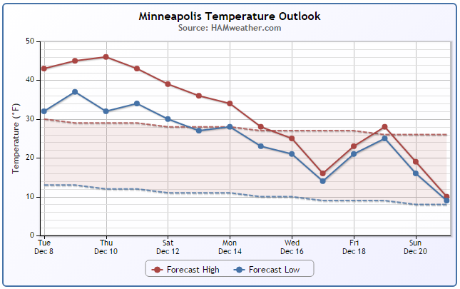
Minneapolis Temperature Trend
It appears that we're in for several more days of well above average temperatures before any substantial cooling takes place. At or near average temperatures may finally start to move in by early next week with at or below average temperatures possible as we move past mid month.
______________________________
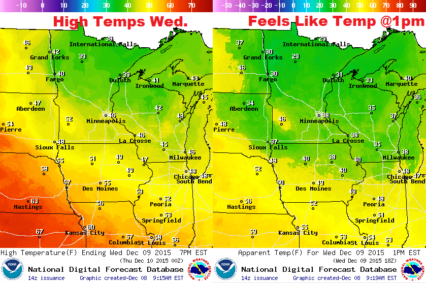
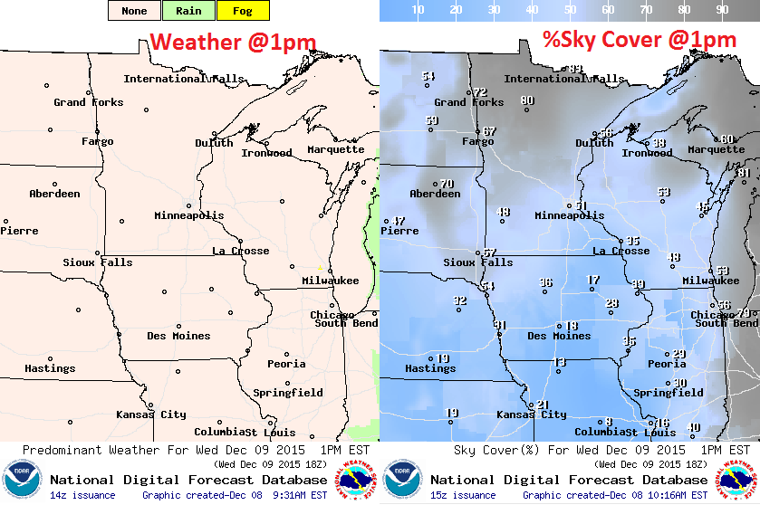
Wednesday Weather Outlook
Wednesday will be another mild day with temperatures warming into the 30s and 40s across the state. There may even be some 50s showing up across the southwestern part of the state! Keep in mind that temperatures will be nearly 10F to nearly 20F above average across much of the Upper Midwest.
Wednesday Weather Outlook
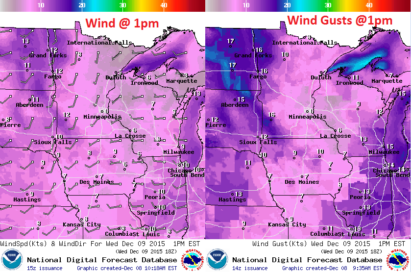
A southwesterly breeze will help keep mild temperatures pumping into the region on Wednesday. Winds will also be picking up quite a bit on Thursday as an impulse of energy slides through with a rain/snow mix across the northern half of the state.
Wednesday Weather Outlook
After a few showers on Tuesday, weather conditions will improve a little on Wednesday with a little more sunshine across the southern half of the state.
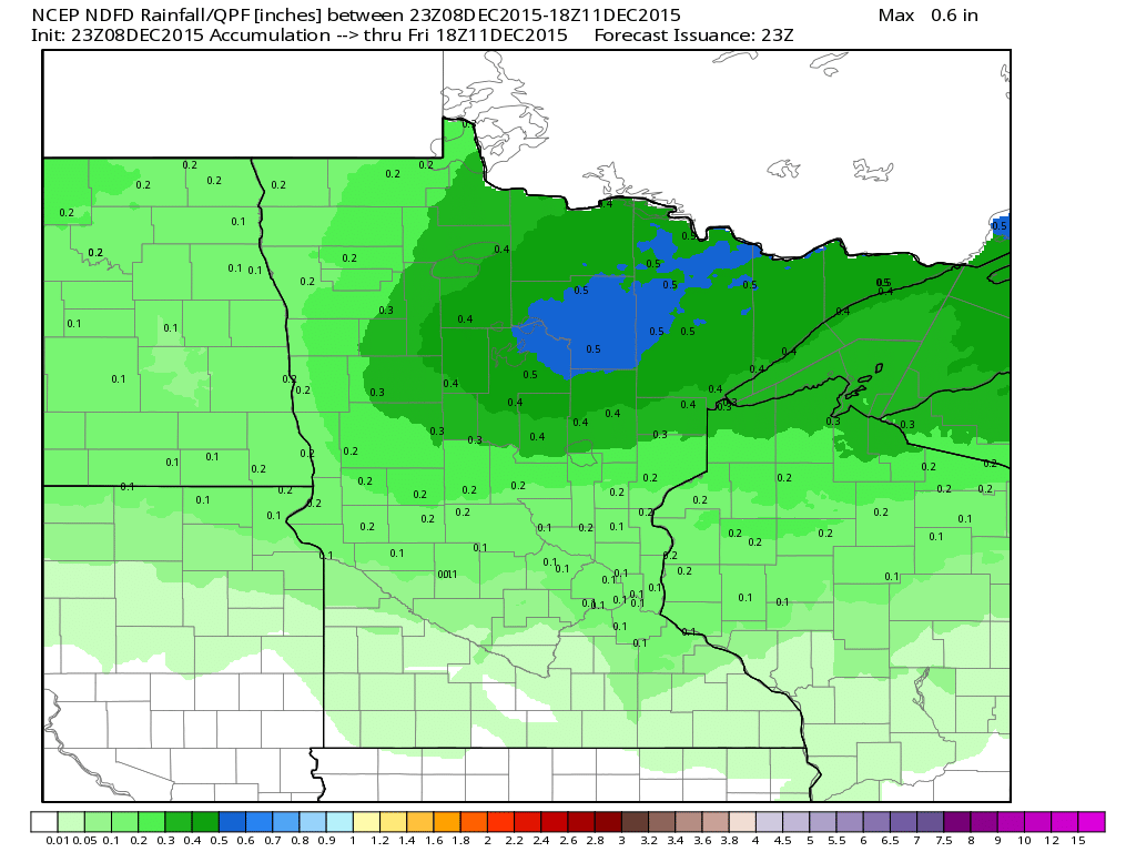
Minnesota Rainfall Potential
Another weak impulse of energy will scoot through the region on Thursday with heavier precipitation values across the northern half of the state, which may include a little snow.
______________________________
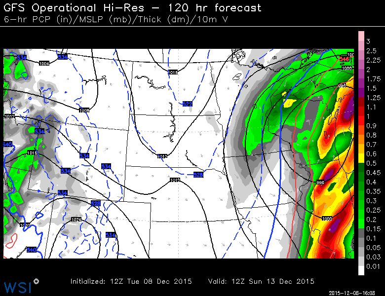
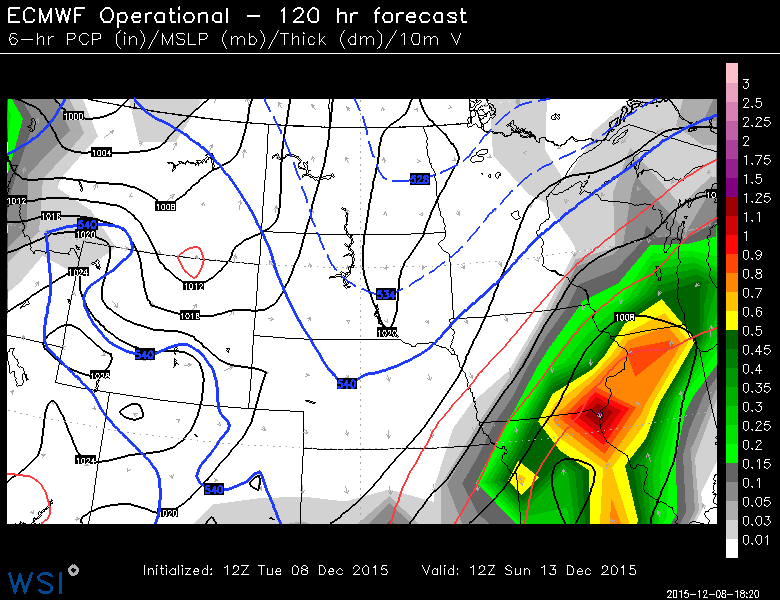
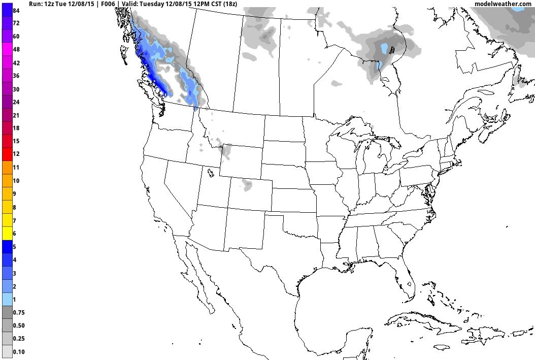
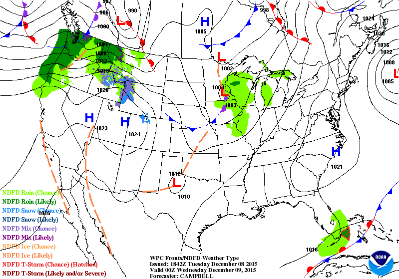
Weekend Storm System?
Models have been suggesting something developing this weekend, which could bring snow chances back to parts of the Upper Midwest. It's too early to tell the exact track of the storm, but it will dictate where snowfall will fall. Here are two different model solutions (below) at the same time period. Note that one shows moisture (likely snow) over parts of Minnesota and Wisconsin, while the keeps farther south. This is still a developing system, so stay tuned.
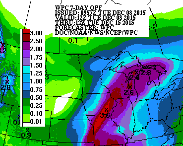
7 Day Precipitation Outlook
Regardless if snow falls across parts of the area this weekend, it does appear that some may be in for a wetter weather pattern over the next 7 days. According to NOAA's WPC, the 7 day precipitation forecast suggests as much as 1" to 3"+ liquid for some from the Middle Mississippi Valley to the Great Lakes.
Increasing Snowfall Potential?
Several impulses of energy will continue to lash the West Coast with strong winds and copious of amounts of moisture over the next several days. The loop below suggests snowfall potential through the middle part of next week. Note that significant snowfall tallies will be possible in the higher elevations along the West Coast, while snowfall chances look to be increasing across the Upper Midwest.
______________________________
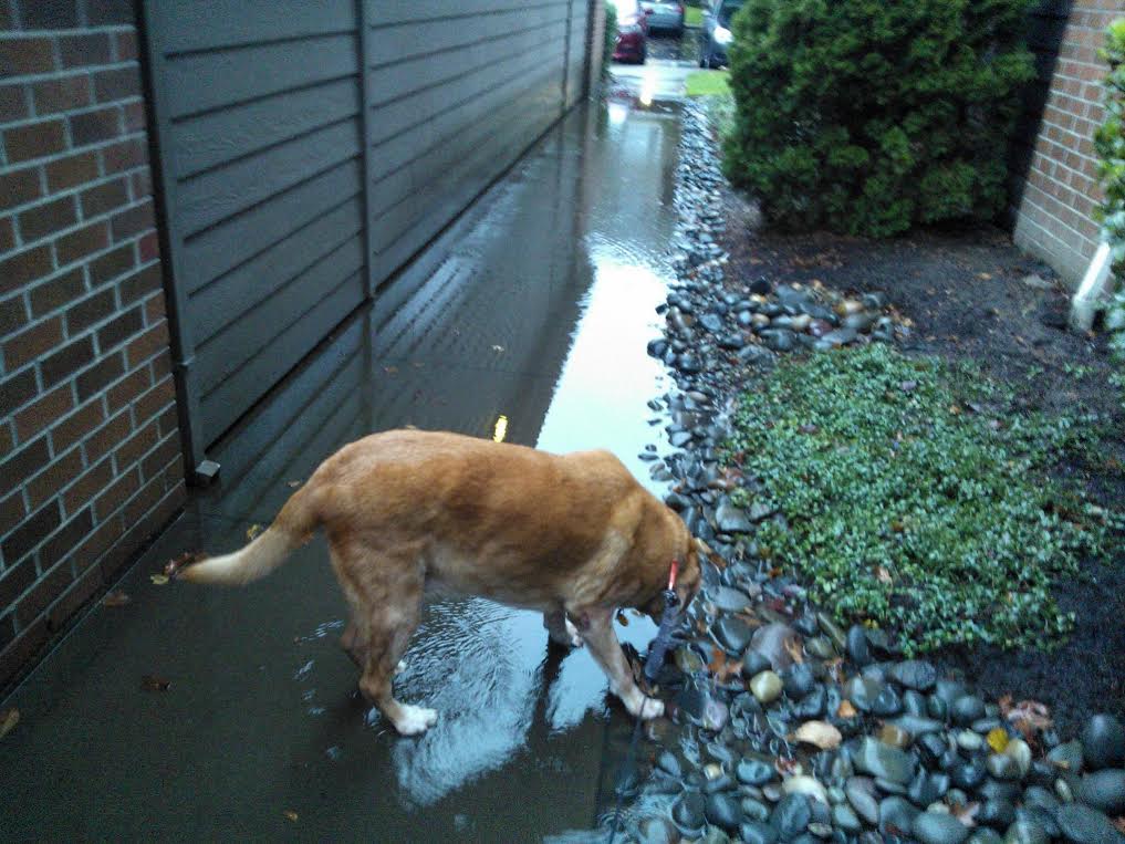
Soggy Dog
Thanks to my uncle Jim Gust for this picture out of Portland, OR, where his soggy dog, Freyja, seems to be a little unsure of the record setting rains that hit the area on Monday. My uncle is recent transplant from Minnesota and seems to be getting a wet welcome to the Pacific Northwest! Thanks uncle Jimmy!
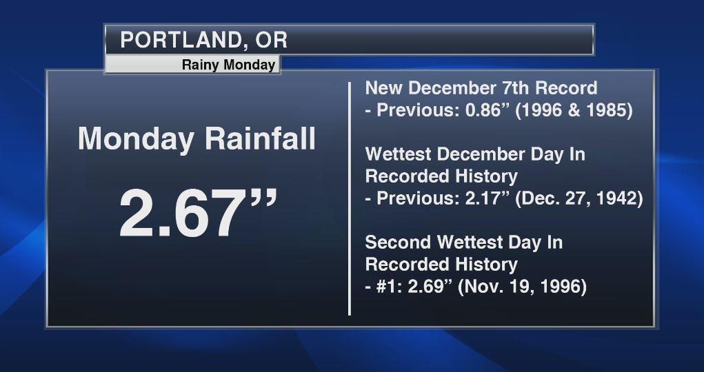
Impressive Precipitation in the Pacific Northwest
It has been very soggy as of late in the Pacific Northwest with daily rainfall amounts reaching record levels. In fact, 2.67" of rain fell in Portland, OR on Monday, which not only becomes a daily rainfall record for December 7th, but it also becomes the wettest December day on record and also the 2nd wettest day on record!! Wet weather looks to continue over the next several days too!
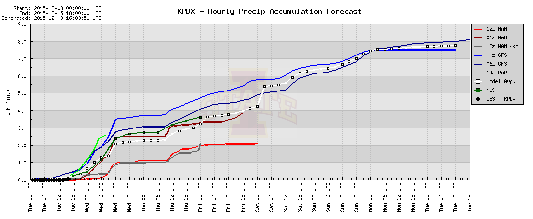
More Wet Weather Ahead
Take a look at the hourly precipitation forecast below for Portland, OR. Interestingly, the GFS (longer range model) is suggesting nearly 7" of rain possible by this weekend!
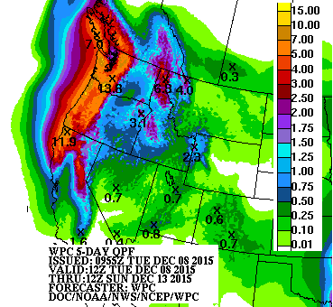
5 Day Precipitation Forecast
According to NOAA WPC, the 5 day precipitation forecast suggests significant precipitation potential with as much as 6" to 12"+ liquid possible through AM Sunday! This will likely cause flooding in some prone locations.
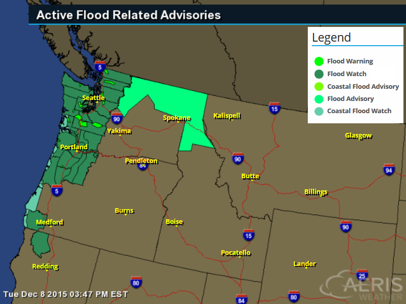
Flood Concerns
A number of flood headlines have been issued over the next several days due to heavy rainfall potential. With as much rain in such a short amount of time there may be several areas that may be susceptible to flooding.
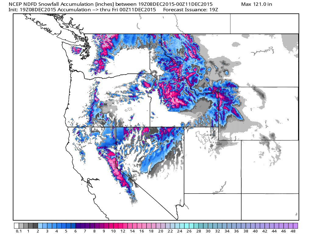
Northwest Snowfall Potential
Here's the snowfall potential through 6pm Thursday. Note that several locations from the northern Cascades to the Sierra Nevada Range and the northern Rockies have a good chance of nearly a foot or more of snow!
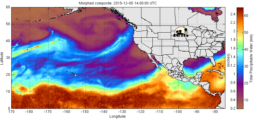
Pacific Precipitable Water Loop
It's pretty impressive to see wave after wave of Pacific moisture pushing into the Pacific Northwest in the loop below. Note how bright these ribbons of moisture are as they stream northeast, this is connected to high levels of moisture available in the atmosphere, therefore leading to high quantities of moisture being deposited in the Pacific Northwest.
_____________________________
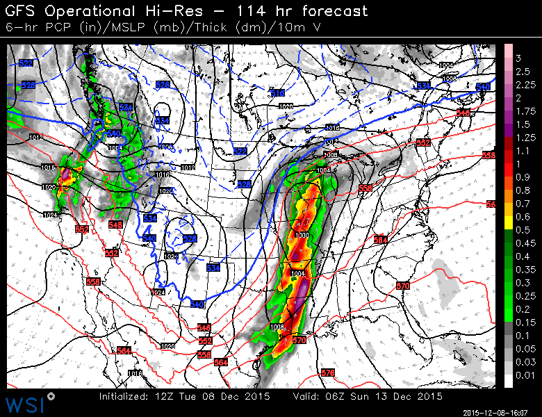
National Weather Outlook
We've seen a fairly steady stream of Pacific moisture in the Pacific Northwest over the past few days with weak impulses of energy breaking off and heading through the Midwest with lighter precipitation amounts. The next big surge of Pacific moisture will start moving east through midweek, which will develop into a much larger storm system that will bring showers and storms to parts of the Southern Plains by the weekend.
Weekend Thunder Threat
This is the outlook for Saturday, which shows a line of showers and storms extending from near the Great Lakes to the Lower Mississippi Valley. Some of the storms PM Saturday could be a little on the strong side across the Lower Mississippi Valley with heavy rainfall potential
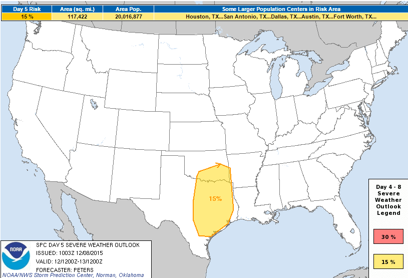
Severe Threat Saturday
According to NOAA's SPC, the Storm Prediction Center has a highlighted area of strong to possibly severe thunderstorms that may develop on Saturday from southern Oklahoma to eastern Texas.
THE 00Z ECMWF/GFS BEGIN TO DIVERGE WITH THE
   EAST/NORTHEAST PROGRESSION OF THE FOUR CORNERS TROUGH INTO THE
   SOUTHERN AND CENTRAL PLAINS.  HOWEVER...EACH MODEL AGREES WITH THE
   TIMING OF A LOWER-AMPLITUDE SUB-TROPICAL SHORTWAVE TROUGH FORECAST
   TO MOVE NORTHEAST ACROSS THE MOISTENING/DESTABILIZING WARM SECTOR IN
   THE EASTERN HALF OF THE SOUTHERN PLAINS SATURDAY.  CAPE/SHEAR
   PARAMETER SPACE SUPPORTS AN INCREASING POTENTIAL FOR SEVERE STORMS
   SATURDAY AFTERNOON AND EVENING...WITH VERTICALLY VEERING WIND
   PROFILES SUGGESTING BOTH A TORNADO THREAT AND DAMAGING WINDS WILL BE
   POSSIBLE.  THIS SCENARIO IS SUPPORTED BY THE COMBINED CAPE/SHEAR
   PROBABILITIES FROM THE 00Z ECMWF ENSEMBLE AND THE 00Z GEFS.
____________________________________
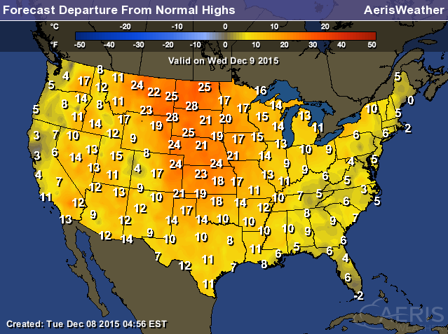
Highs From Average Wednesday
Highs on Wednesday will be very warm across the nation. Note that most locations in the Central U.S. will be nearly 10F to 25F above average! This will be more reminiscent of November rather than December!
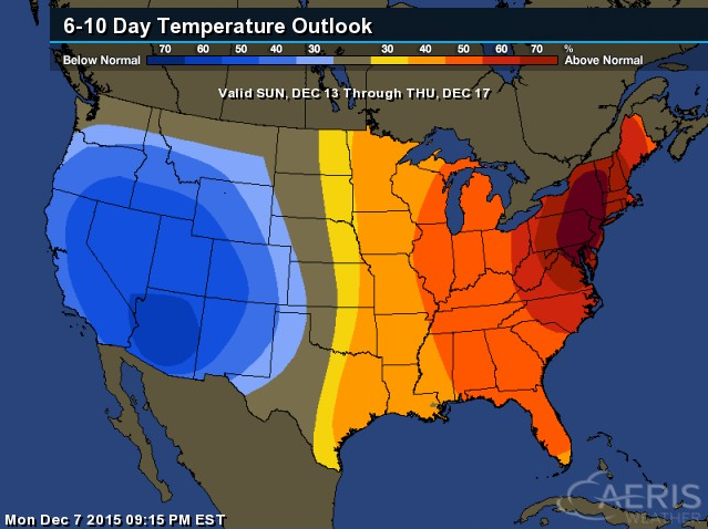
6 to 10 Day Temperature Outlook
According to NOAA's CPC, the 6 to 10 day temperature outlook shows warmer than average temperatures across the Eastern U.S., while temperatures look to be cooling down across the Western U.S. by mid month.
______________________________________
Top U.S. Scientist: World Must Act Now to Reverse Climate Change
"LE BOURGET, France—As global leaders open their final week of negotiations, the White House's top scientist spoke with National Geographic to offer his thoughts on why it's urgent for countries to tackle the climate crisis now—and why he's optimistic about the future for his grandchildren. Here's our conversation with John Holdren, President Obama’s science and technology advisor. It has been lightly edited and condensed."
Read more from National Geographic HERE:
__________________________________________
Thanks for checking in and have a great rest of your week! Don't forget to follow me on Twitter @TNelsonWX

No comments:
Post a Comment