60 F. high in the Twin Cities Sunday.
36 F. average high on March 6.
39 F. high on March 6, 2015, after waking up to 7 F.
March 7, 1987:
A heat wave across Minnesota brings the earliest 70 degree readings on
record to the Twin Cities. The record high for the day was 73, breaking
the old record by 13 degrees. Shorts were common and people were turning
over dirt in their gardens for planting.
March 7, 1950:
A snow and ice storm hits Minnesota. The heaviest ice was in northwest
and west central Minnesota, especially in Norman County near Twin
Valley. 52 electrical poles were down in this area with ice up to 1 ½
inches on wires. All communication lines out of Fargo were out with wind
gusts estimated up to 60 mph. In order to provide temporary long
distance service to and from isolated communities, short wave radio
equipment was used to bridge the gaps. In Pipestone, several plate glass
windows were blown in. During the snowstorm that followed later in the
day, a Northwest Airlines plane crashed into three homes in Minneapolis
killing all 13 on the plane and two on the ground. The left wing of the
plane struck a flagpole at Ft. Snelling National Cemetery as it circled
to land.
 You Really Slept In - Welcome to April 7, 2016
I'm a big believer in time travel. Or maybe it's just an acute case of sleep deprivation. Thank you Netflix.
I set the alarm but - somehow - ALL of us are waking up to
April 7. As far as our fickle atmosphere is concerned it's early April with low 60s - a few scattered thunderstorms by
tonight. Maybe my tax accountant will call and brighten my day? The fog of winter is just a slushy memory now.
We
cool off by midweek (only 10-15F warmer than average) before another
transfusion of mild Pacific air arrives. More 60s are possible
Friday into next weekend with a few sloppy claps of thunder by
Sunday.
Warm
fronts in March are hardly unusual. What's bizarre is the sheer
persistence of the warm signal, going well above and beyond the
additional heat thrown off by a major El Nino event. This is El Nino on
turbo-steroids.
NOAA's GFS model hints at a soaking (rain) storm the middle of next week, followed by a cool correction after
March 18 or so.
We
may enjoy a few days in the 30s later this month - even a slushy
encounter or 2. But snow days, wind chill, car starters? Ancient
history.
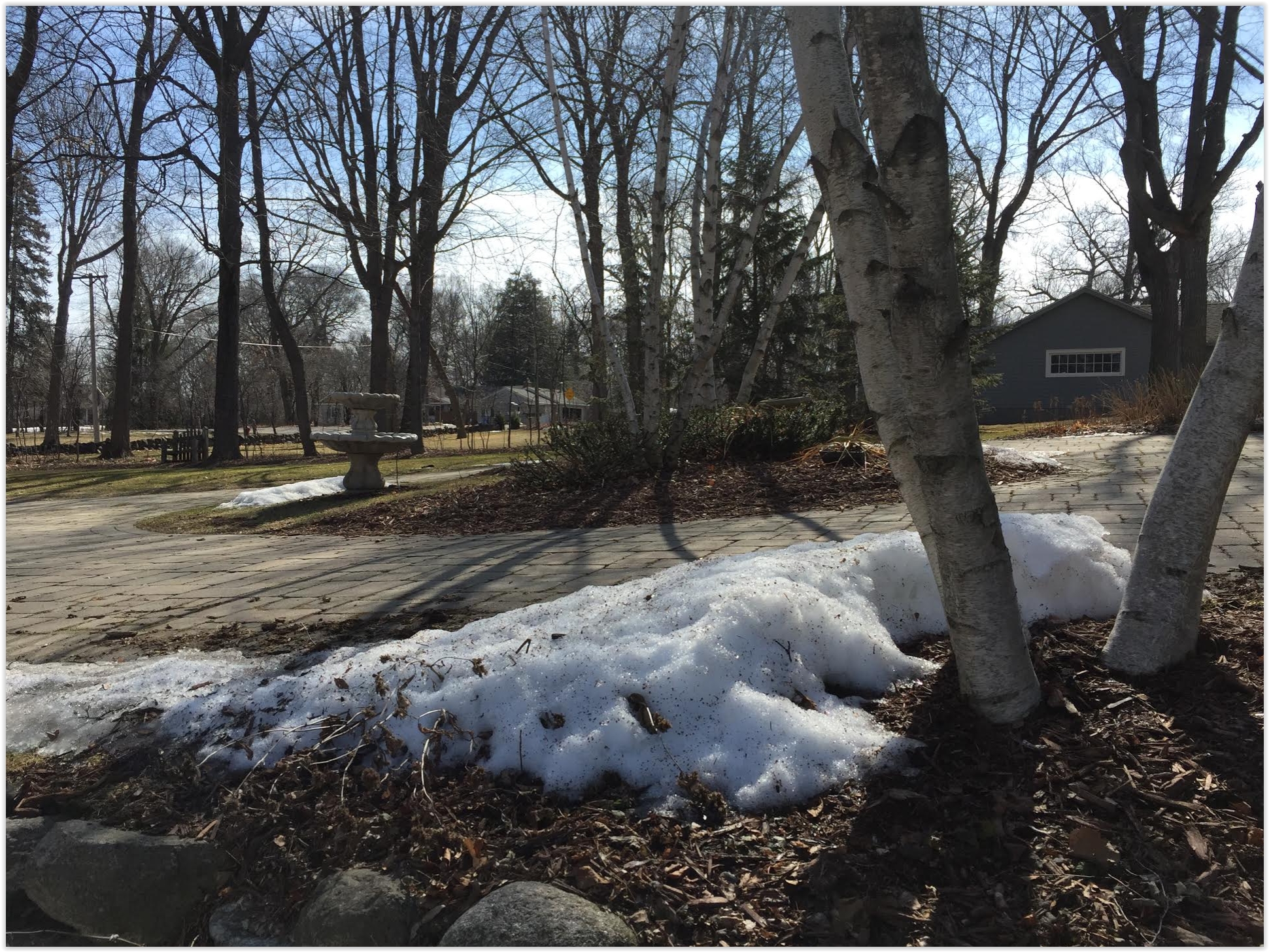
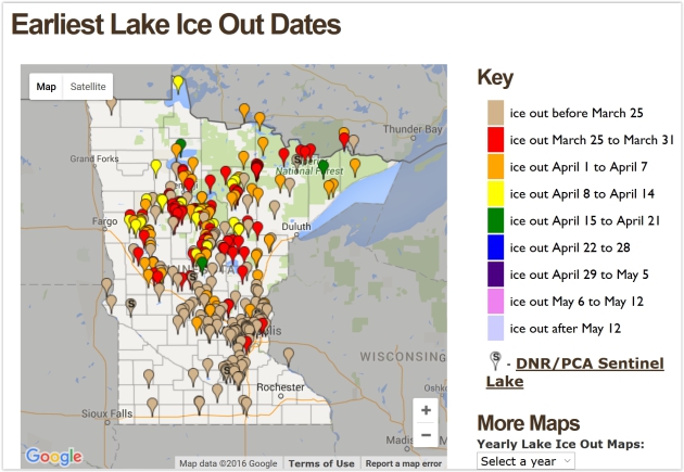
Record Early Ice Out Dates on Minnesota Lakes.
The ice came off Lake Calhoun on March 9, 2000. Lake Mille Lacs and
Gull Lake? March 26, 2012. Click here for an interactive map with record
(early) ice-out dates, courtesy of the
Minnesota DNR.
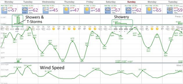
Strong Hints of Spring.
After peaking near or just above 60F today and Tuesday we cool off
slightly by midweek, before warming up again next weeked with another
round of 60s. If you don't have the fever yet, give it a few days - you
will. Source: WeatherSpark.
Tracking Showers and T-showers in Early March.
A surge of moisture from the south increases the chance of rain showers
today, especially PM hours, enough marginal instability and moisture
for a stray thundershower tonight or early Tuesday. 84-hour future
precipitation loop: NOAA and AerisWeather.
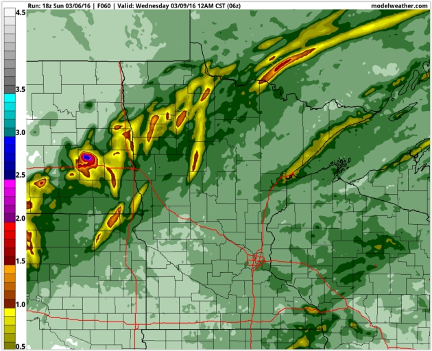
Predicted Rainfall Amounts.
Heaviest rains are predicted for the Red River Valley, where some .5
to 1" amounts are possible. In the metro I expect just enough rain to
settle the dust, probably under a tenth of an inch.
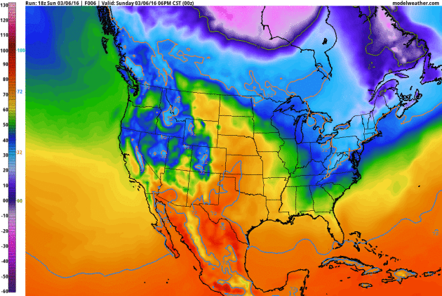
Fast-Forward Spring.
Much of the Lower 48 will experience a premature jolt of spring as the
core of numbing air lifts north and east of Hudson Bay, Canada. Again,
the pattern is more typical of early April, and when it gets too warm
too fast there's usually a correction. Nothing like January, but don't
pack away the heavy jackets just yet. GFS 2-meter temperature forecast
for the next 10 days: NOAA and AerisWeather.
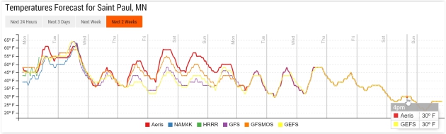
Hints of a Correction.
After trending well above average into next week models show a downward
spiral within 2 weeks; perhaps 30s for highs after March 18-19. With a
rapidly rising sun angle it can't get nearly as cold as it did in early
February, but don't rule out a couple more slushy slaps toward the end
of March. Source: Aeris Enterprise.
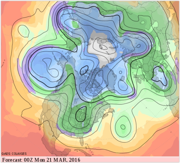
A Subtle Yet Blunt Reminder (That It's Still March).
500 mb predicted winds for Sunday evening, march 20, show a colder,
northerly wind flow aloft as a slow-moving cut-off low lingers over the
Great Lakes. Cold enough for slushy snow? Probably.
More Significant Rain Late Next Week?
Confidence levels are still low, but GFS guidance is fairly consistent,
pulling southern moisture into Minnesota by the end of next week with
some 1"+ amounts.
Warm (and Wet) Signal Grows.
An energized southerly branch of the jet stream will hurl a series of
very wet storms into the west coast; a plume of Gulf moisture drenching
the Lower Mississippi Vally with 4-8" rains later this week. Flash
flooding is likely.
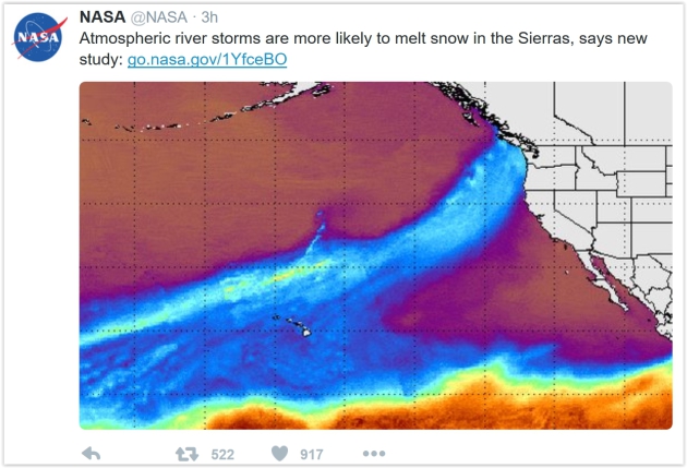
Study: Atmospheric River Storms Can Reduce Sierra Snow. Here's an excerpt from
NASA: "
A
new study by NASA and several partners has found that in California's
Sierra Nevada, atmospheric river storms are two-and-a-half times more
likely than other types of winter storms to result in destructive
“rain-on-snow” events, where rain falls on existing snowpack, causing it
to melt. Those events increase flood risks in winter and reduce water
availability the following summer. The study, based on NASA satellite
and ground-based data from 1998 through 2014, is the first to establish a
climatological connection between atmospheric river storms and
rain-on-snow events. Partnering with NASA on the study were UCLA;
Scripps Institution of Oceanography, San Diego; and the Earth System
Research Laboratory, Boulder, Colorado..."
Why Nuclear Energy Can Help Fight Climate Change. Here's an excerpt of an Op-Ed from former EPA Administrator Christine Todd Whitman at Fortune: "America
is facing critical decisions as a country about how to combat climate
change, and it’s imperative that those decisions are based on solid
facts as we shape a clean energy future for the U.S. We are at a turning
point, and if we are going to effectively fight climate change, we will
need every carbon-free source of electricity we can bring to bear.
Although many misconceptions persist about the safety record of nuclear
power facilities, the truth of the matter is that 61 nuclear power
facilities in the country have been safely operating for more than 50
years. U.S. nuclear power plants have been a model of U.S. industrial
safety for more than 50 years, powering communities, keeping the air
clean and fueling state and local economies..." (File image: CNN).
iPhone 7 Rumors: Thinner with Stereo Speakers? 9to5Mac has the speculative piece; here's a clip: "...
Next,
the blog reports that the iPhone 7 will feature stereo speakers, making
it the first iPhone to do so. In the past, all iPhone models have only
featured a single mono speaker, so the addition of a second speaker
should greatly improve the device’s sound quality. Finally, in yet
another effort to keep the thickness of the device down, the iPhone 7
may feature a thinner Lightning port than previous devices..."
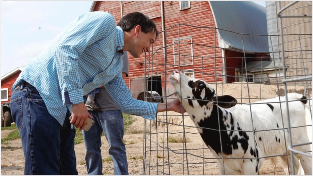
A Change of Heart: Journalist Who Reported Minnesota County is "Worst Place to Live" Is Moving There. Karmic justice? Here's an excerpt of an interesting tale at
The Grand Forks Herald: "...
Ingraham triggered a social media storm after he penned "Every county in America, ranked by scenery and climate"
in mid-August. The article listed the best and worst places to live in
the contiguous U.S. based on measurable qualities, including sunny
winters, temperate summers, low humidity, topographic variation and
access to a body of water, researched by the U.S. Department of
Agriculture. Red Lake County, which is known for being the only
landlocked county in the country surrounded by two neighboring counties,
ranked last in Ingraham's article. In fact, almost every county in
Minnesota and North Dakota had extremely low to low natural amenities,
according to the article..."
Photo credit above: "
Christopher
Ingraham is greeted by a dairy cow during his tour of Red Lake County,
"the ugliest county in the country" , on Thursday, August 27, 2015, in
Red Lake Falls, Minn." (Logan Werlinger/Grand Forks Herald).

 TODAY
TODAY: Mild with fading sun, PM shower possible. Winds: S 10-15. High: 61
MONDAY NIGHT: Humid, chance of a few showers, possible T-storm. Low: 54
TUESDAY: Early thunder, feels like April with slow clearing. Winds: SW 15-25. High: 62
WEDNESDAY: Mostly cloudy and cooler. Winds: NW 8-13. Wake-up: 38. High: 47
THURSDAY: Partly sunny and pleasant. Winds: NW 5-10. Wake-up: 33. High: 51
FRIDAY: Mild sunshine, leaving work early. Winds: S 10-15. Wake-up: 42. High: 62
SATURDAY: Clouds increase, late shower? Winds: S 7-12. Wake-up: 47. High: 61
SUNDAY: Few showers, possible T-showers. Winds: SW 7-12. Wake-up: 52. High: 63
Climate Stories....
Climate Change Resistant Crops Needed. Threat - and opportunity. Here's the intro to a story at
MSN News: "
More
investment is needed to develop climate change resistant varieties of
crops to prevent paying the "ugly" price of food shortages, an expert
has warned. Rising temperatures are set to hit key crops, damaging food
supplies and sparking national security and geopolitical threats,
according to Dr Cary Fowler, former head of the Crop Trust and member of
the board advising US government aid agency USAID on agriculture.
Investing in developing varieties of crops that are resistant to
drought, floods or high temperatures, were "low-cost investments with a
big pay-off", he suggested. But a failure to do so could prompt
starvation, malnutrition and war or unrest..."
The Mercury Doesn't Lie: We've Hit a Troubling Climate Change Milestone. Bill McKibbon has an Op-Ed at
The Boston Globe: "
Thursday,
while the nation debated the relative size of Republican genitalia,
something truly awful happened. Across the northern hemisphere, the
temperature, if only for a few hours, apparently crossed a line: it was
more than two degrees Celsius above “normal” for the first time in
recorded history and likely for the first time in the course of human
civilization. That’s important because the governments of the world have
set two degrees Celsius as the must-not-cross red line that,
theoretically, we’re doing all we can to avoid. And it’s important
because most of the hemisphere has not really had a winter. They’ve been
trucking snow into Anchorage for the start of the Iditarod; Arctic sea
ice is at record low levels for the date; in New England doctors are
already talking about the start of “allergy season...”
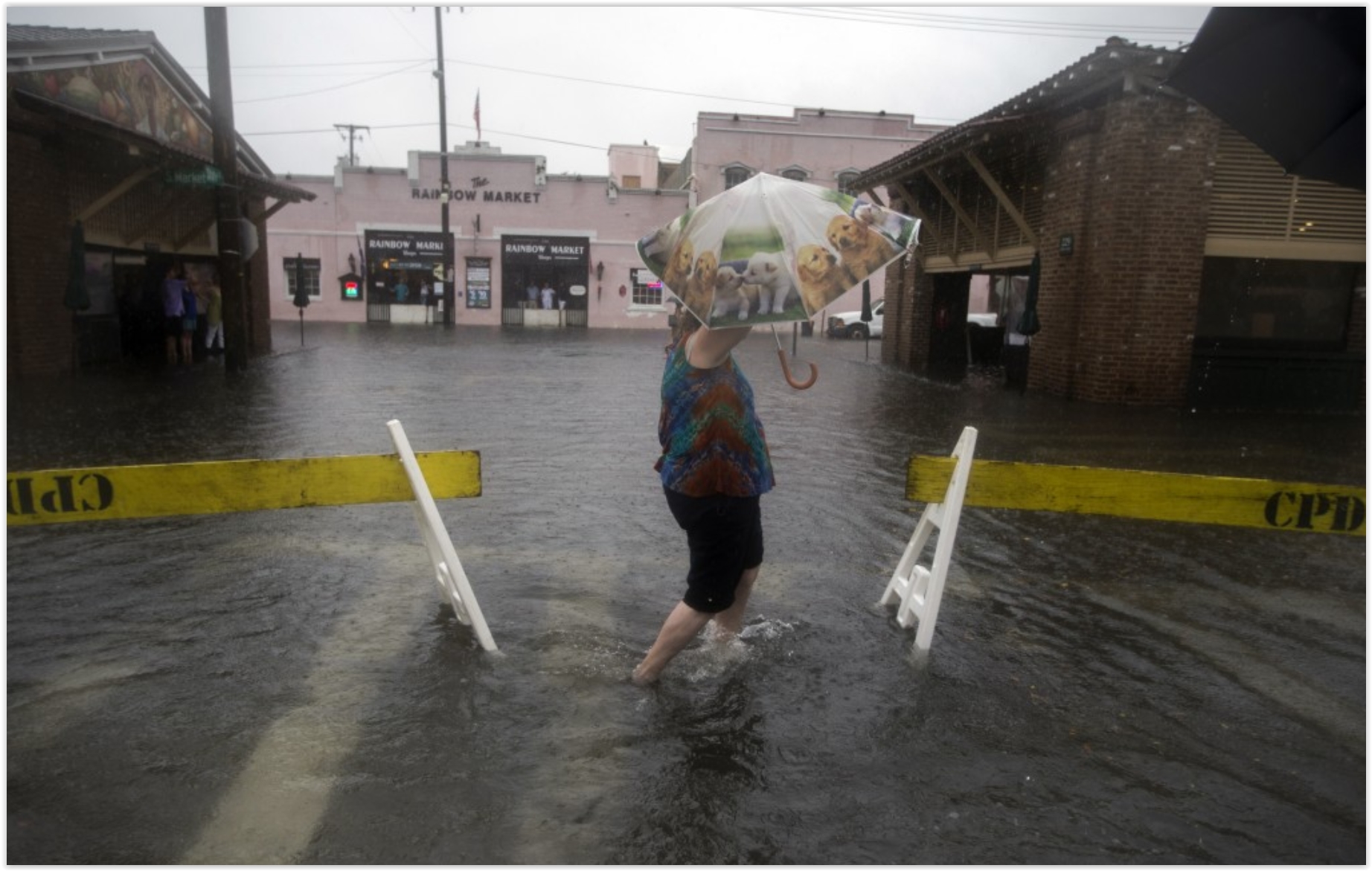 The Fight to Hear Debate Questions on Climate Change in a State Struggling With Sea Level Rise.
 Here's a clip from
ThinkProgress: "...
Both
the Democratic and Republican presidential candidates will be headed to
Miami next week in advance of their next primary debates. Local
Floridians, already on the front lines of climate change as rising seas
spill into their neighborhoods, want them to talk about climate change.
Cindy Lerner is the Mayor of Pinecrest, a coastal suburb of Miami. She
and 14 other South Florida mayors sent letters to GOP candidates Marco
Rubio and Jeb Bush (before he ended his campaign) asking to meet
with them about climate change. Both candidates agreed when Lerner went
to New Hampshire to make the request in person. Bush has since dropped
out of the race, and she is still trying to schedule a meeting with
Rubio next week..." (File image: Stephen B Morton, AP).
 Scientist Joanna Haigh Warns Global Warming is a "Runaway Train"
. Here's a snippet from an interview at
Financial Times: "...
Haigh
says global warming is like a runaway train. Unless we put the brakes
on, it will keep on rolling. People may argue about whether we’ll see 2C
or 5C of warming this century, she says. “But if you ever want the
global temperature to plateau, you’ve got to get to zero carbon
emissions.” Zero? Haigh is firm. “At some stage we’ve got to bite the
bullet.” Is that really going to happen? The 2015 UN Climate Change Conference in Paris
buoyed Haigh: 195 governments made surprisingly ambitious pledges. “I’m
a careful optimist,” she says. “I think that the wind is in the right
direction now.”


No comments:
Post a Comment