First Lightning Death of 2016
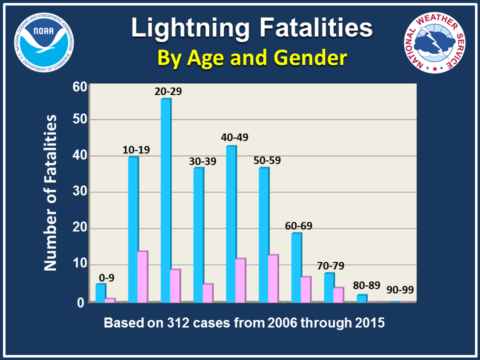
Lightning
struck the T-Bois Blues Festival in Larose, LA Friday evening and
unfortunately killed a 28 year old woman. She becomes the first
lightning death of 2016. Click to read more from The Times-Picayune.
________________________________________________
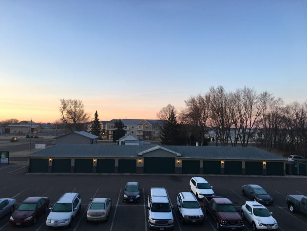
Another Frosty Sunday
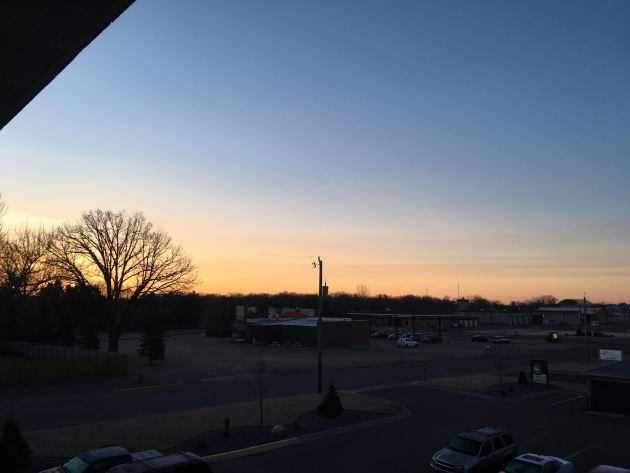
You
needed your jacket heading out Sunday morning as lows dipped below
freezing across much of Minnesota once again. It made for a great
sunrise, though!
Even
though we've seen warm weather this month, we're certainly not out of
the woods just yet in terms of seeing lows at or below freezing. The
average last low at or below freezing across the entire Twin Cities
record doesn't occur until April 28. Last year our last at/below
freezing low was on April 23rd, when it got down to 29. Even the
earliest last at/below freezing low on record didn't occur until the
month of April - that was April 6th of 1878.
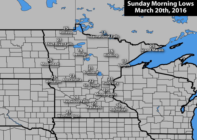
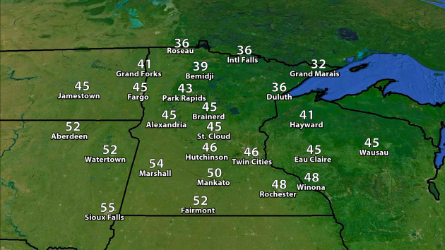
Here
was a look at lows across the state Sunday morning. The warmest spot
was down in Winona, which only dipped down to 32 degrees. The coolest
airport location was up north at Crane Lake, which fell to 9 degrees.
_______________________________________________
Revisiting The Snow Last Week On The North Shore
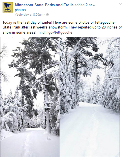
Heavy snow fell between March 15th and 17th up in northeast Minnesota, with some of the heaviest snow falling near Tofte and Lutsen. The top report was just northwest of Lutsen, where 13" of snow was reported. These pictures from Tettegoughe State Park make it look like the middle of winter along parts of the North Shore! Of course, we're (quickly) nearing the end of March, which means this snow won't last too long - but hopefully it is enough to kill off any bugs that may have already popped up during our warm beginning to March.
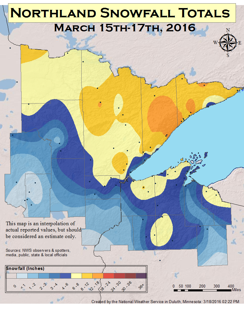
Here is a map of totals across northeast Minnesota and northern Wisconsin from the snowfall last week - click to read more about the storm from NWS Duluth.
_______________________________________________
Welcome to Reno: March Trends Cool and Quiet
By: Paul Douglas
By: Paul Douglas
Excelsior.
Nisswa. Seaside. Coronado. Happy Valley. Lancaster. Zermatt. Jerusalem.
Vancouver. Anywhere on Maui. What's your Top 10 list, the places you
keep coming back to? Your dream destinations?
Everyone's
list will be different. Only one thing is constant. I will be
personally blamed for lousy weather. "When's the sun coming out honey? I
thought you said it would get warmer!" Sorry, I'm away from my Doppler.
Check the weather apps on your phone. Hope for the best.
Every
spot on Earth deals with micro-climates, odd gyrations in temperature
& moisture triggered by mountains or water. The forecast will never
be perfect - anywhere. Pack sunglasses AND an umbrella for spring break.
We get a break from storms looking out 2 weeks; models hinting at a brush with slush Wednesday night, again Sunday.
An El Nino-fueled pattern continues to nudge the main storm track just
to our south into next week. Temperatures approach 50F today; low-50s
will feel good tomorrow before cooling off by midweek.
And quoting the band Crowded House, "Everywhere you go always take the weather with you."
_______________________________________________
Extended Forecast for Minneapolis
MONDAY: Fading sun, milder. High 49. Low 36. Precipitation Chance: 10%. Wind: SE 10-15 mph.
TUESDAY: Some sun, feels like spring. High 53. Low 34. Precipitation Chance: 20%. Wind: NE 7-12 mph.
WEDNESDAY: Cooler, light mix possible. High 39. Low 29. Precipitation Chance: 50%. Wind NE 10-20 mph.
THURSDAY: Storm moves away, slow clearing. High 38. Low 27. Precipitation Chance: 30%. Wind NE 10-15 mph.
FRIDAY: Mostly cloudy, stiff breeze. High 46. Low 35. Precipitation Chance: 10%. Wind: S 10-20 mph.
SATURDAY: Lingering clouds, risk of a shower. High 43. Low 34. Precipitation Chance: 40%. Wind: N 10-15 mph.
SUNDAY: Slushy mix may pass south/east of MSP. High 39. Low 28. Precipitation Chance: 60%. Wind: NE 10-15 mph.
_______________________________________________

Damage from a tornado that hit the St. Cloud area back on March 21st, 1953. Image via the Minnesota Historical Society.
This Day in Weather History
March 21st
March 21st
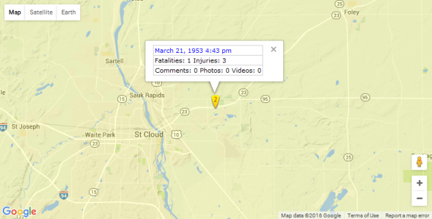
Map of tornado in the St. Cloud area back in 1953 (via the Tornado History Project).
*Length Of Day: 12 hours, 14 minutes and 13 seconds
*Daylight Gained Since Yesterday: ~3mins & 9secs
*Next Sunrise That Is Before 7 AM: March 29th (6:58 am)
*Next Sunset That Is After 8 PM: April 16th (8:01 pm)
_______________________________________________
Average Temperatures & Precipitation for Minneapolis
March 21st
March 21st
Average High: 44F (Record: 76F set in 1938)
Average Low: 26F (Record: -8F set in 1865)
Average Precipitation: 0.07" (Record: 0.83" set in 1904)
Average Snowfall: 0.3" (Record: 3.9" in 2008)
________________________________________________
Average Low: 26F (Record: -8F set in 1865)
Average Precipitation: 0.07" (Record: 0.83" set in 1904)
Average Snowfall: 0.3" (Record: 3.9" in 2008)
________________________________________________
Sunrise/Sunset Times for Minneapolis
March 21st
March 21st
Sunrise: 7:13 AM
Sunset: 7:28 PM
Sunset: 7:28 PM
*Daylight Gained Since Yesterday: ~3mins & 9secs
*Next Sunrise That Is Before 7 AM: March 29th (6:58 am)
*Next Sunset That Is After 8 PM: April 16th (8:01 pm)
________________________________________________
Graphic: March high temperatures each day so far in the Twin Cities. Courtesy Iowa Environmental Mesonet
A Mainly Warm March So Far. It
feels like spring has gotten an early start this month across the
region, even though Sunday was only the first full day of spring,
astronomically speaking. Through Saturday, the March average temperature
in the Twin Cities has been 41.2 degrees, 11.1 degrees above average,
on the back of eight 50 or above days. That means the first 19 days of
March were the fourth warmest on record, just behind third place 1894,
which saw an average temperature of 41.4 degrees over the same period of
time.
Since the beginning of the month,
three record highs have been set in the Twin Cities (March 8th, 11th and
12th). Looking statewide, Climatologist Mark Seeley in his weekly WeatherTalk blog stated that, "(s)o
far this month over 60 new daily warm maximum temperature records have
been reported across Minnesota, and over 60 new warm daily minimum
temperature records have been reported as well."
________________________________________________
Monday Minnesota Weather Outlook
Temperatures
will continue their upward climb as we head into a shortened work week
for some with Good Friday coming up. Highs should make it into the mid
to upper 40s, right around average for this time of year. Temps in the
30s will be common across northern Minnesota, with some 50s in southwest
and south central parts of the state, including Marshall and Mankato.
We'll
see mainly cloudy skies across much of the state throughout the day
Monday, with a chance of snow diving out of Canada as we head into
Monday Night and Tuesday across the north. Forecast loop above: 7 AM Monday through 1 AM Tuesday. Graphic source: Aeris Weather.
Through
Tuesday afternoon, snow totals across northern Minnesota could range
between 1-3" from this clipper-like low that will be moving though. Not a
big deal, especially against what they saw last week. Graphic source: Aeris Weather.
________________________________________________
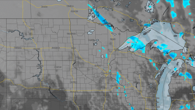
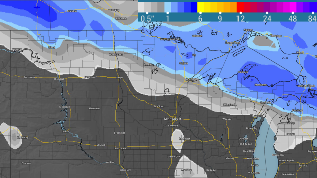
Mid-Week Snowstorm?
 Graphic: NWS Twin Cities
Personally,
I've had a feeling Mother Nature wasn't done with winter just yet and
would have at least one surprise up her sleeve. That may come true later
this week as a deepening low pressure center moves out onto the Plains,
bringing with it a band of potentially heavy snow somewhere across the
upper Midwest. Where this happens is yet to be determined - some of the
latest runs of the GFS still had the heaviest snow across southern
Minnesota, including parts of the metro, meanwhile the European model has shifted any large accumulations south of I-90.
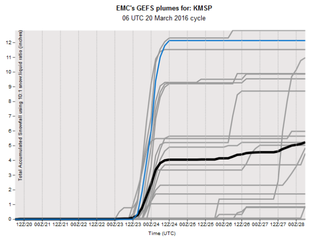
The
spread in snowfall totals can be seen in this graphics of the GEFS
plumes for the Twin Cities, showing the metro could pick up anywhere
between 0-12" of snow, depending on which difference in variables you so
choose. There's still a lot to be determined over the next few days, so
stay tuned as we'll have the latest.
________________________________________________
National Weather Outlook
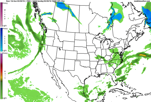
As
we head into the day Monday, we'll be watching a system moving away
from New England, but not before bringing 6"+ of snow to parts of
Massachusetts and Maine. In the Northwest, wave after wave of moisture
will be moving through, with rain totals of an inch or two. It will be
the main system associated with that moving on shore Monday that will
bring someone in the upper Midwest the chance of heavy snow by the
middle of the week.
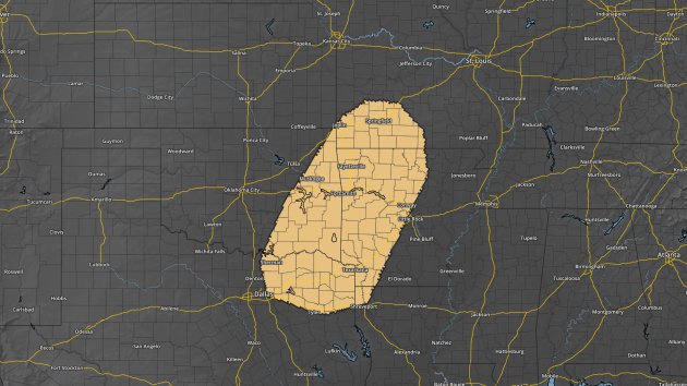
As
we head into the middle of the week, severe weather will creep back
into our minds, with an area from Dallas to Springfield, MO already
outlined for the potential of severe weather Wednesday. This would be associated with the same low pressure center that will bring the upper Midwest snow.
Rainfall
through Tuesday will be heaviest in the Pacific Northwest, with 1"
(green) possible along the coast from Washington through northern
California. Southwest Oregon and Northwest California has the potential
for the heaviest totals (2-4") during that time frame.
Meanwhile,
snowfall through Tuesday will be heaviest across parts of eastern
Massachusetts and Maine, where some areas could end up with 6" (mainly
Sunday Night into Monday). Out west, a few inches of snow is possible in
the mountains, with some areas potentially topping 6" by Tuesday Night.
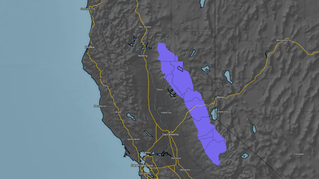
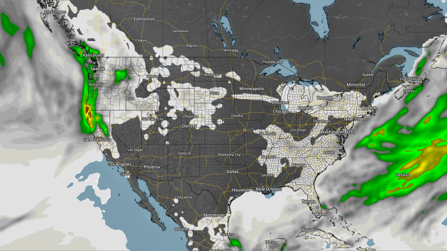
Winter
Weather Advisories are up for parts of the Sierra in California for the
upcoming snow between Monday morning and Tuesday morning. The forecast
is falling for 4-8" above 4,500 feet with locally heavier totals at the
highest peaks.
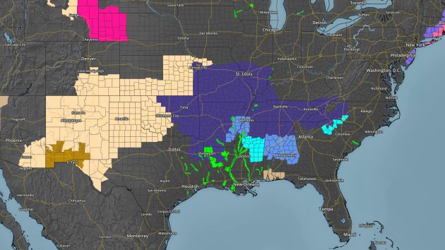
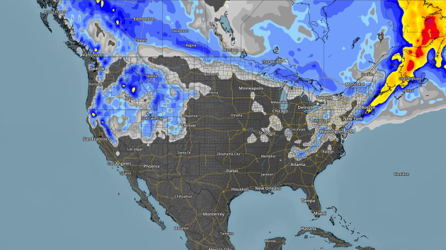
The
other big story is the frost and freeze concern Monday morning across
portions of the southern U.S. Freeze Warnings (dark blue) and Frost
Advisories (lighter blue) are in effect as temperatures are expected to
drop into the 20s and low 30s across these regions.
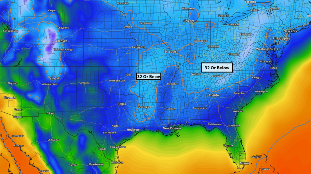
Here
is a look at forecast lows Monday morning, which are expected to drop
below freezing as far south as parts of Texas and Louisiana. Hopefully
residents have covered up any plants that are already starting to bloom
in these regions.
________________________________________________
Thanks for checking in and have a great week! Don't forget you can follow me on Twitter (@dkayserwx) or on Facebook (Meteorologist D.J. Kayser)!
- D.J. Kayser

No comments:
Post a Comment