Midwest Snowstorm To Bring 6-12" Of Snow Across Southern Minnesota
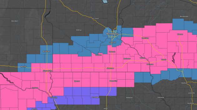
Watches and Warnings As Of Tuesday Evening. National
Weather Service offices, including the one in the Twin Cities, upgraded
parts of the Winter Storm Watch to a Winter Storm Warning (in pink)
Tuesday afternoon where the confidence was highest that at least 6-12"
of snow could fall Wednesday into Thursday. The Twin Cities NWS office
kept the Winter Storm Watch (blue) for areas from Redwood Falls to Twin
Cities metro due to some models keeping a chance of 6"+ creeping that far north.
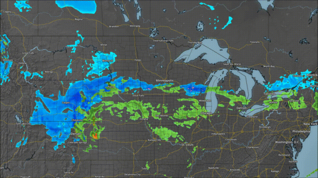
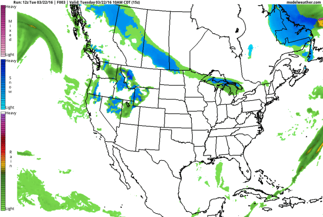
Timing Out The Snow. While some light rain or snow is possible over southern Minnesota Wednesday morning, the snow will ramp up in the late morning/afternoon
hours across the Twin Cities lasting through Wednesday Night with a few
inches possible. It currently appears the heaviest will stay south of
the metro - more on totals in a moment. The snow quickly pushes out
Thursday morning and we should see mostly sunny skies return during the
day Thursday.
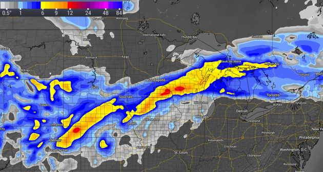
Potential Snow Totals. The Monday night models threw a lot of people for a loop, as most of the
main ones moved the potential of 6"+ closer to the Twin Cities.
However, some of the more trusted computer models in the Tuesday morning
run pushed the heaviest snow totals back to our south. There are still a few models trying to bring
heavier snow into the metro as of Tuesday evening, but I'm not sure I
buy into them just yet - we need to see where the precipitation sets up
heading into tomorrow morning. Right now the forecast is for 1-4" of
snow across the Twin Cities metro - with the greatest chance of 3-4"
across the south metro. It is still snow, so chances are high that it
will likely slow traffic a bit for the Wednesday evening commute and
potentially Thursday morning, but currently not the half a foot that was
possible in the Monday night model runs.
_______________________________________________
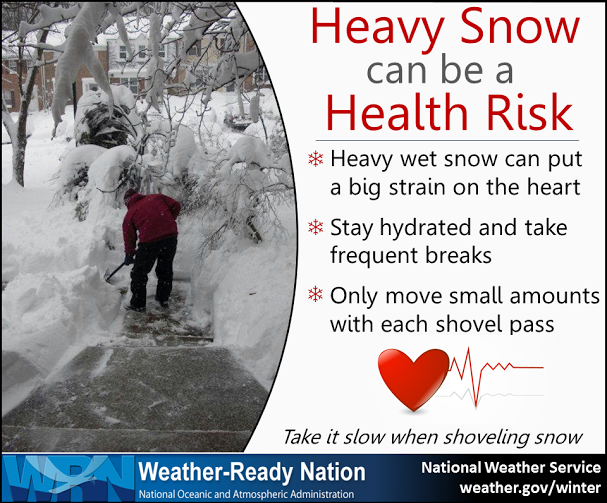
"Heart Attack Snow". We are expecting what does fall over the next couple days to be a heavy, wet snow -
the type that takes a bit more effort to remove from sidewalks and
driveways. That can put a strain on your heart and cause health problem.
Make sure to take it easy removing the snow that does fall.
_______________________________________________
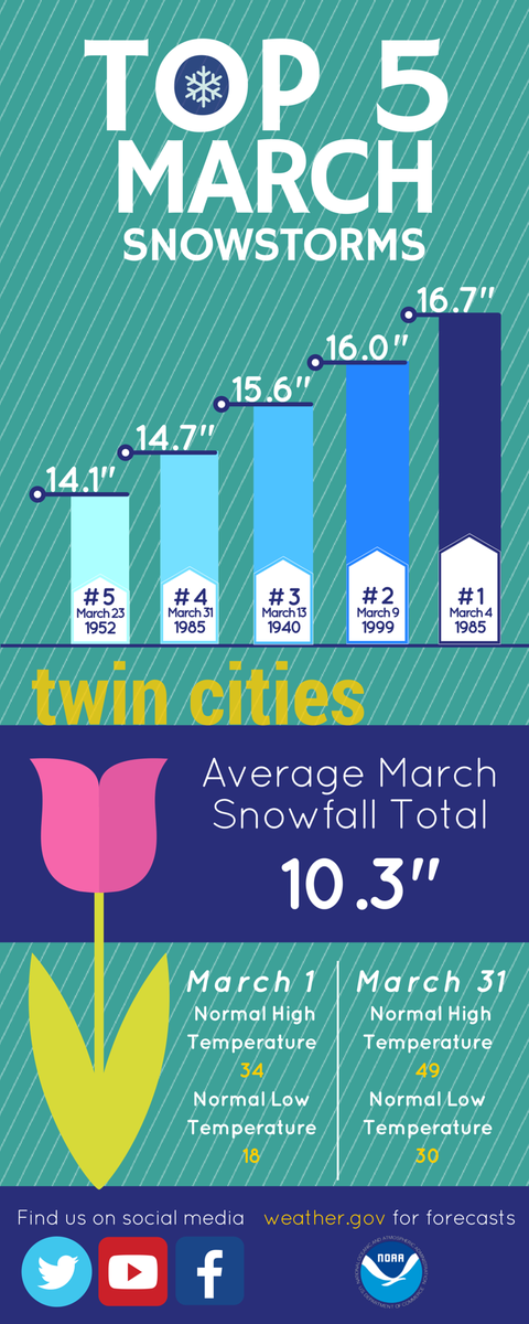
Top March Snows. While
we are certainly not expecting this much snow to fall in the metro, the
Twin Cities office of the National Weather Service put out this graphic
showing the top five daily March snowfall totals in the Twin Cities.
The top daily snow? 16.7" back on March 4th of 1985.
_______________________________________________
Panic Optional - Ankle Deep in Slush
By: Paul Douglas
By: Paul Douglas
Watches,
warnings and breathless bromides of BREAKING NEWS! An alien invasion in
Blaine? An imminent volcanic eruption in Willmar? Nope, just a
candy-coating of slush.
I have discovered, the
hard way, that it's best to be conservative with snow amounts. If the
models predict 6 inches cut it in half and you'll (usually) be closer to
the mark. Because snow storms, given a choice, prefer to avoid the Twin
Cities.
Weather models are more useless than
usual; NOAA guidance hints at plowable amounts, but ECMWF keeps the
heavy snow bands south of the metro. I expect a couple slushy inches but
the most hype-worthy amounts (over 6 inches) should pass south of MSP.
We're
on the northern edge of the storm; a 50-mile shift in its track could
mean the difference between an inch - or 4 inches. Not the end of the
world, just a reassuring reminder that it can snow in March - in
Minnesota.
Skies clear Thursday; showers Saturday give way to cool sun on Sunday. I see another run of 50s the middle of next week with rain.
Take a deep breath. No volcanoes or aliens. It's just snow. It'll melt.
_______________________________________________
Extended Forecast for Minneapolis
WEDNESDAY: Wet snow, 1-3" at MSP. High 36. Low 25. Chance of Precipitation: 80%. Winds: NE 15-30 mph.
THURSDAY: Skies clear, snow gradually melts. High 41. Low 29. Chance of Precipitation: 10%. Wind: NW 7-12 mph.
FRIDAY: Clouds and winds increase. High 46. Low 37. Chance of Precipitation: 30%. Wind: S 10-20 mph.
SATURDAY: Few showers, wet roads. High 42. Low 30. Chance of Precipitation: 60%. Wind: NW 10-15 mph.
SUNDAY: Sunnier, nicer day of the weekend. High 45. Low 32. Chance of Precipitation: 10%. Wind: NW 5-10 mph.
MONDAY: Mostly cloudy, risk of a shower. High 46. Low 33. Chance of Precipitation: 30%. Wind: SE 5-10 mph.
TUESDAY: Intervals of sun, feels like spring. High 55. Low 44. Chance of Precipitation: 10%. Wind: SE 10-15 mph.
_______________________________________________
This Day in Weather History
March 23rd
1966: A snowstorm brings a foot of snow to southern Minnesota.March 23rd
_______________________________________________
Average Temperatures & Precipitation for Minneapolis
March 23rd
March 23rd
Average High: 45F (Record: 83F set in 1910)
Average Low: 27F (Record: -4F set in 1965)
Average Precipitation: 0.07" (Record: 1.18 in 1966)
Average Snowfall: 0.3" (Record: 11.6" in 1966)
________________________________________________
Average Low: 27F (Record: -4F set in 1965)
Average Precipitation: 0.07" (Record: 1.18 in 1966)
Average Snowfall: 0.3" (Record: 11.6" in 1966)
________________________________________________
Sunrise/Sunset Times for Minneapolis
March 23rd
March 23rd
Sunrise: 7:10 AM
Sunset: 7:30 PM
*Length Of Day: 12 hours, 20 minutes and 31 secondsSunset: 7:30 PM
*Daylight Gained Since Yesterday: ~3mins & 9secs
*Next Sunrise That Is Before 7 AM: March 29th (6:58 am)
*Next Sunset That Is After 8 PM: April 16th (8:01 pm)
________________________________________________

Great Lakes Commercial Shipping Season Begins In Duluth.
Shortly after 4 AM Tuesday morning, the Edwin H. Gott left Duluth
Harbor, kicking off the shipping season in the port city. For those
waiting for the first inbound boats, you won't have to wait long. The
Duluth Seaway Port Authority says that two boats, the Stewart J. Cort
and the Burns Harbor, are expected to arrive Saturday.
You can watch boats come and go from Duluth Harbor on two webcams that the Lake Superior Marine Museum has (which is where the above image came from, courtesy of NWS Duluth for posting it to their twitter feed).
________________________________________________

Wednesday: World Meteorological Day. Wednesday is World Meteorological Day, commemorating the day the World Meteorological Organization was established back in 1950. Every year they focus on a theme - this year's theme, tied to climate change, is "Hotter, Drier, Wetter. Face the Future." Read more from the WMO.
________________________________________________
National Outlook
The
threats from the low ejecting onto the Plains will be two-fold as we
head into Wednesday and Thursday. We already talked about the first
threat - the snow across the northern U.S. - but the second will be in
the warm sector with severe weather. We'll get to that threat in just a
moment. Back out west we'll watch another wave of moisture move onshore
in the Pacific Northwest late Wednesday Night. As we reach the end of
the forecast period in our loop (Friday evening) a clipper system will
be diving south out of Canada bringing the potential of some rain and
snow to parts of the northern Rockies and upper Midwest to begin the
weekend. Parts of northern Minnesota could pick up an inch or two of
snow in association with that clipper.
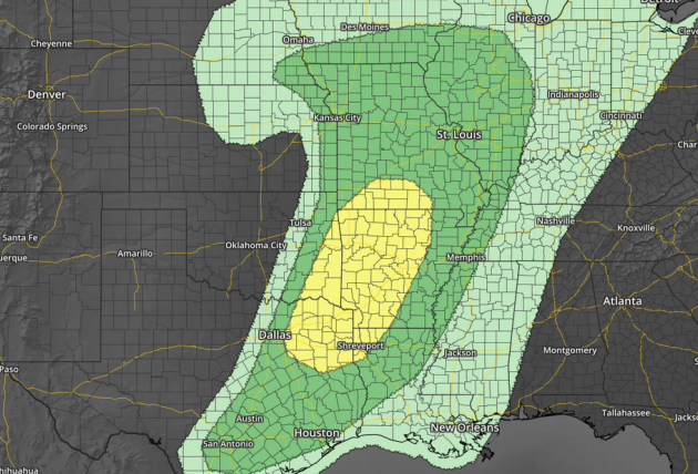
The threat of severe storms Wednesday exists from parts of southern Iowa and northern Illinois south into Texas. Large hail, damaging wind and a tornado or two is possible from these storms, particularly in the yellow highlighted area from south-central Missouri into northeast Texas.

Severe Risk Thursday. Graphic: AerisWeather
The
severe weather risk will shift off to the east on Thursday, from
southern Ohio to the Gulf Coast. The main threat on Thursday will be
damaging winds.
________________________________________________
Thanks for checking in and have a great Wednesday! Don't forget you can follow me on Twitter (@dkayserwx) or on Facebook (Meteorologist D.J. Kayser)!
- D.J. Kayser

No comments:
Post a Comment