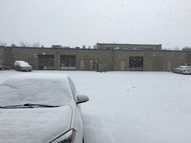
Snowy Friday Across The Twin Cities
A
heavy burst of snow moved through the metro Friday morning, sliding
south and east during the commute and causing a number of accidents,
particularly in the northwest metro.
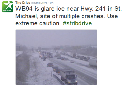
This
was just one of many bottlenecks that occurred due to the heavily
accumulating snow, which quickly turned to glare ice during the morning
commute. According to the State Patrol, 59 crashes occurred in the
metro area between 6 am and 10:45 am Friday morning, as well as six vehicles
that slid off/went off the road. In the St. Cloud area, where it started
snowing before 7 am Friday morning, there were 34 crashes reported and
14 vehicles
that slid off/went off the road.
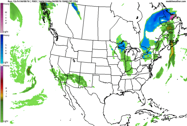
 Radar loop between 5 AM and 1 PM Friday.
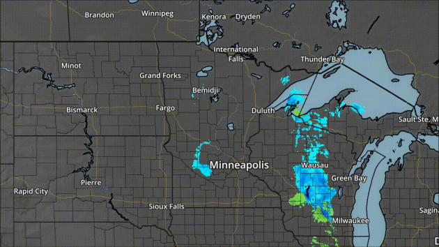
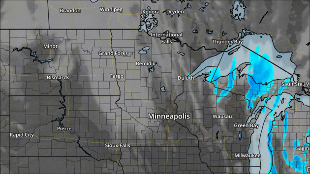
The
radar loop from Friday morning shows the batches of snow that moved
through the metro - one which took aim on the west metro
during the morning commute, and a second which went through the east metro
later in the morning. This wasn't the only snow that fell in spots,
though, as convective snow showers popped up later in the afternoon. The
snow Friday morning was sparked by an upper level trough moving through
the region.
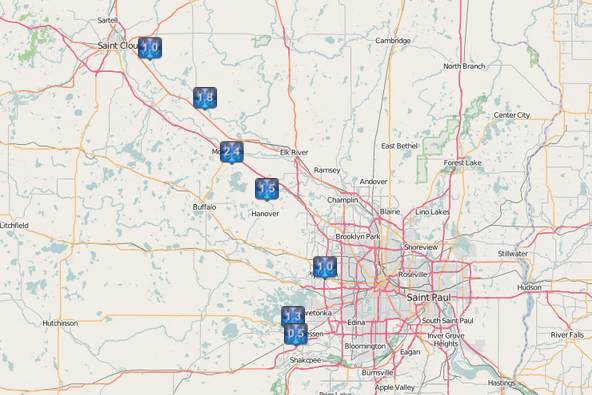
Here
was a
look at the snow totals across the Twin Cities metro, stretching up to
St. Cloud, through 6 PM Friday Night. The heaviest snow totals in the
region: 2.4" in Monticello and 1.8" north of Becker. Officially 1.1"
fell in St. Cloud and 0.5" fell at both the MSP Airport and at the NWS
office in Chanhassen. While totals weren't all that impressive, they
certainly caused a number of headaches.
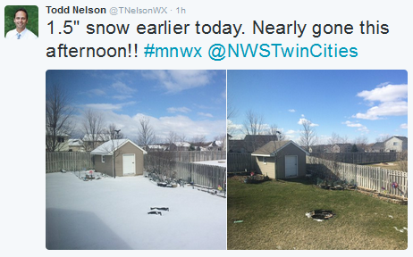
The
good news is that it is April, and the sun angle is getting strong.
Because of this, the snow quickly melted once the sun came out. One good
example is from my colleague Todd Nelson, who picked up 1.5" Friday in
his backyard that was all gone by the end of the day.
_______________________________________________
In Need of Some Serious Weather Therapy
By: Paul Douglas
By: Paul Douglas
Some
days I'm more improvisational-amateur-therapist than meteorologist.
Yesterday, after a freakish snow squall made it look like early
February, was one of those days. "CAN'T U DO SOMETHING, NOW EVERYONE'S
COMPLAINING! WE NEED (sun wearing sunglasses icon)!!" a friend of 30
years texted. "GIVE IT A WEEK. 70s WITHIN 7 DAYS" I answered, trying to talk Heidi off the ledge.
The last couple of weeks have been character-building; an inevitable relapse coming after a balmy March.
We
could be navigating thigh-high snow drifts, monitoring flooding rivers
or dodging early tornadoes. This isn't so bad, all things considered.
A frosty start gives way to low 40s today; 50s tomorrow will feel like a minor revelation after this morning's stinging wind chill. The odds of a Sunday
shower have diminished, and after a more reasonable cool frontal
passage early next week a shift in the pattern guides Pacific air back
into Minnesota. How mild? At least 60s; both ECMWF and GFS guidance
hints at a few 70s by next weekend.
Winter's last gasp? Probably. Sorry, it still wasn't much of a winter.
_______________________________________________
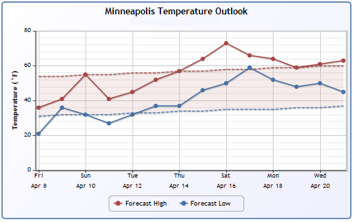
Twin Cities Seven Day Forecast
SATURDAY: Frosty. Clouds increase. High 42. Low 36. Chance of Precipitation 10%. Wind SE 10-15 mph.
SUNDAY: Early shower, then clearing. High 55. Low 32. Chance of Precipitation 40%. Wind NW 10-15 mph.
MONDAY: More clouds than sun, brisk. High 42. Low 25. Chance of Precipitation 10%. Wind NW 15-25 mph.
TUESDAY: Bright sun, winds diminish. High 46. Low 33. Chance of Precipitation 0%. Wind SE 5-10 mph.
WEDNESDAY: Partly sunny, milder breeze returns. High 57. Low 42. Chance of Precipitation 0%. Wind S 10-20 mph.
THURSDAY: Mild sun, feels like spring again. High 62. Low 46. Chance of Precipitation 10%. Wind S 10-15 mph.
FRIDAY: Clouds increase, take off early. High 68. Low 48. Chance of Precipitation 20%. Wind SE 10-20 mph.
_______________________________________________
This Day in Weather History
April 9th
1931: Severe dust storms are reported in St. Paul.April 9th
_______________________________________________
Average Temperatures & Precipitation for Minneapolis
April 9th
April 9th
Average High: 55F (Record: 81F set in 1930)
Average Low: 34F (Record: 15F set in 1997)
Average Precipitation: 0.08" (Record: 0.75" set in 1919)
Average Snowfall: 0.1" (Record: 5.5" in 1894)
________________________________________________
Average Low: 34F (Record: 15F set in 1997)
Average Precipitation: 0.08" (Record: 0.75" set in 1919)
Average Snowfall: 0.1" (Record: 5.5" in 1894)
________________________________________________
Sunrise/Sunset Times for Minneapolis
April 9th
Sunrise: 6:38 AMApril 9th
Sunset: 7:52 PM
*Length Of Day: 13 hours, 13 minutes and 31 seconds
*Daylight Gained Since Yesterday: ~3mins & 4secs
*Next Sunrise That Is Before 6:30 AM: April 14th (6:29 am)
*Next Sunset That Is After 8 PM: April 16th (8:01 pm)
________________________________________________
Saturday Minnesota Weather Outlook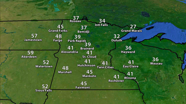
We'll
continue our cool start to April as we head into Saturday across the
region as highs will only reach the low 40s in the Twin Cities. The
good news is that winds will not be as strong on Saturday as they were
Friday - however, even with winds from the southeast at 5-15 mph, it
will
only feel like the 20s and 30s. Across northern Minnesota, highs will
only top off in the 20s and 30s, but feel more like the teens
and 20s.
A
mix of clouds and sun are expected across the southern part of the
state on Saturday, with the best snow chances staying across northern
Minnesota as a cold front sweeps through toward the evening and
overnight hours. Across the Twin Cities, a shower is possible Saturday
Night - sitting at about a 30% chance.
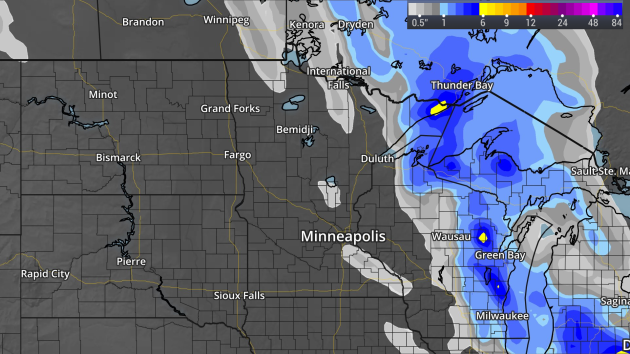
The
snow forecast from late Friday through Sunday morning shows the
heaviest will be up in the Arrowhead, with a few inches possible on top
of 12"+ still on the ground in spots.
Don't Worry... Spring Is In The Forecast!
We
have only seen one day so far this month with an average temperature
that was above average - back on the 3rd, which also was the last time
we saw a 60 degree or higher temperature. The good news is that we
should be adding to that list soon - we just have to wait until the
middle to end of next week. They say good things come to those who
wait...
________________________________________________
National Outlook
Lots
going on on the national weather map over the next couple days. First,
we'll continue to watch a parade of storms across parts of the Great
Lakes that will bring some light rain and accumulating snow with them -
potentially topping six inches in spots by the end of the weekend. A
system will be moving into the Southwest, bringing parts of California,
Nevada and the Four Corners region some rain as we head through the
weekend. As that system heads east to end the weekend, storms will be
sparked across portions of the central and southern Plains, potentially
leading to some severe weather.
Snowy Great Lakes Region
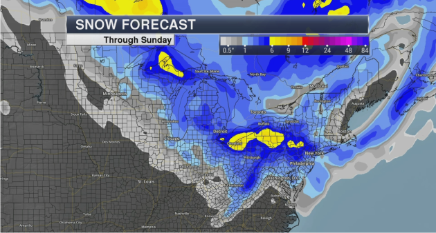
As
the parade of systems continue throughout the region, we will likely
continue to see snow pile up in parts of the Great Lakes. The forecast
through Sunday shows the heaviest totals (6"+) likely across the U.P. of
Michigan as well as across portions of northeast Ohio and northern
Pennsylvania.
Severe Weather Potential To Increase
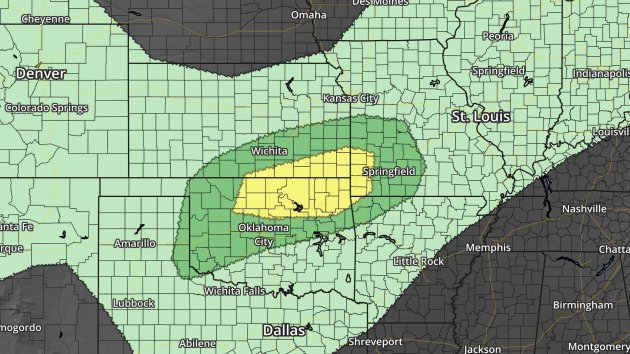
On
the flip side of things, the potential of severe storms will start to increase
across portions of the central and southern Plains as we head toward the
end of the weekend and into next week. This is the severe outlook from
the Storm Prediction Center for Sunday, showing a Slight (yellow) Risk
area across Oklahoma, Kansas and Missouri, and a Marginal (dark green)
Risk area surrounding that. Hail and wind look to be the main threats
over these areas.
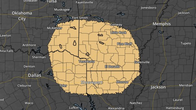
The
severe threat will shift south heading into Monday, including
Shreveport and Little Rock. Hail and wind look to be the main threats
here as well.
Desert Rain
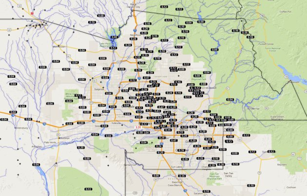
Rain
fell in Phoenix late Thursday for the first time in 66 days, which tied
for the 84th longest stretch without measurable precipitation in the
city. On average, Phoenix sees 0.28" of rain during the month on April
(the third driest month of the year). More rain is in the forecast for
the region Sunday.
Just in case you were
wondering, the longest Phoenix has ever gone without rain was 160 days.
That occurred between December 30th, 1971 and June 6th, 1972.
________________________________________________
Thanks for checking in and have a great weekend! Don't forget you can follow me on Twitter (@dkayserwx) or on Facebook (Meteorologist D.J. Kayser)!
- D.J. Kayser

No comments:
Post a Comment