52 F. average high on April 5.
53 F. high on April 5, 2015.
.07" rain fell yesterday at KMSP.
April 6, 1991: The second of three consecutive record highs, all above 80 degrees, is set at MSP airport (86 on 4/6/1991).
April 6, 1964: A snowstorm hits Minnesota with 9 inches at Fosston and 8.7 at Park Rapids.
Atmospheric Foul Play - Springy By Late Next Week
"You can’t see Canada across lake Erie, but you know it’s there. It’s the same with spring. You have to have faith, especially in Cleveland" mused Paul Fleischman.
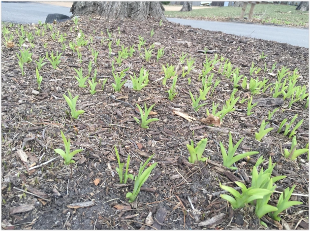
Is this pattern foul or fowl? Only a duck could love this weather. Then again spring is always two steps forward - one step back. Or is it the other way around?
Weather is the pond in which we live, impacting us in a myriad of ways, beyond the obvious. Today comes word of new research showing the risk of concussion and injury in the NFL is twice as high when it's 50F than when it's a balmy 70F at the stadium. If you've ever been tackled on a subzero day that finding should resonate.
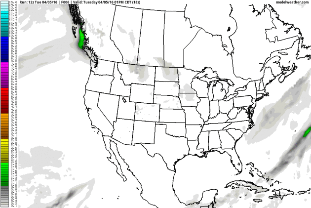
Showers linger today, spiked with wet snowflakes Thursday. A few slushy lawns can't be ruled out by Friday morning - even a few inches of sloppy snow along the North Shore.
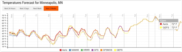
Temperatures bottom out Saturday morning; the atmosphere warm enough for rain showers by Sunday. Models show another minor Canadian intrusion early next week, but a more springlike pattern returns by late next week. Consistent 50s and 60s within 2 weeks?
Bring it.


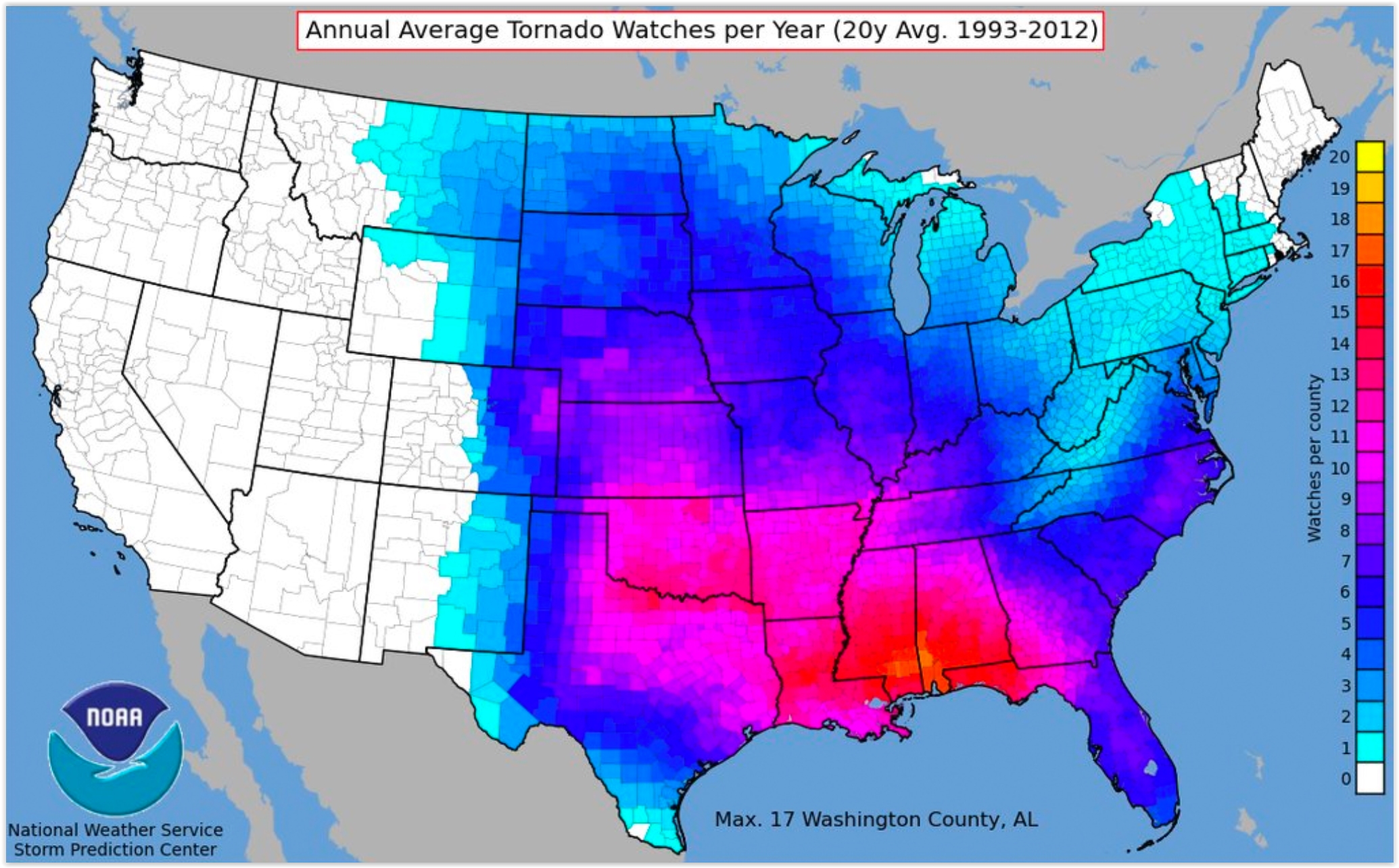
What Counties See The Most Tornado Watches? Southern Alabama sees more tornado watches (on average) than Texas and Oklahoma? Here's an excerpt of an interesting post at The Weather Channel: "...The first map below shows the number of tornado watches issued by county in the United States during the 20-year period 1993-2012. During that time, ten or more tornado watches were issued each year from parts of Kansas, Oklahoma, and north Texas to portions of Alabama, west Georgia and the Florida panhandle. Counties near the Gulf Coast typically see the most tornado watches each year. Washington County, Alabama, tops the list with 17 tornado watches annually..." (Map source: NOAA SPC).
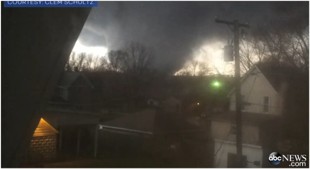
Man Recalls Terrifying Tornado That Took His Wife's Life.
This is the most terrifying and disturbing video I've ever seen of a
direct hit from an (EF-4) tornado in Fairdale, Illinois on April 9,
2015. Here's an excerpt from ABC News: "Cell
phone video captured a terrifying tornado that swept through an elderly
man's home last year, killing his beloved wife of nearly 25 years. On
April 9, 2015, Clem Schultz was at his home in Fairdale,
Illinois, with his wife, Geraldine, known as Geri. "We just finished
supper," Schultz, 85, told ABC News. "My wife called me in the kitchen.
She said, 'Look out the window.' And sure enough I looked out -- we see
this big, ugly tornado coming." "It looked like it was going to miss
us," he said. Geri stayed in the kitchen while he went upstairs to get
some lanterns. As the loud tornado loomed, Schultz decided to start
recording cell phone video..." (more details on this wedge tornado from the Chicago National Weather Service).

Talking About The Weather - and 2016 Outlook.
I'm looking forward to chatting up the weather with Vineeta Sawkar at
The Star Tribune in downtown Minneapolis on April 13. Will El Nino
flip-flop into a La Nina pattern? What are the implications for spring
severe weather and possible drought later this year? This is Vineeta's
final appearance at The Star Tribune. I hope you can come out, wish her
well (and win a new umbrella?) What a deal. More details on the April 13
event here.
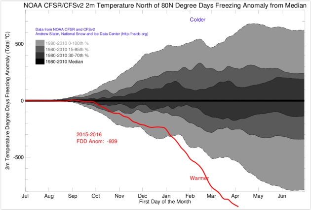
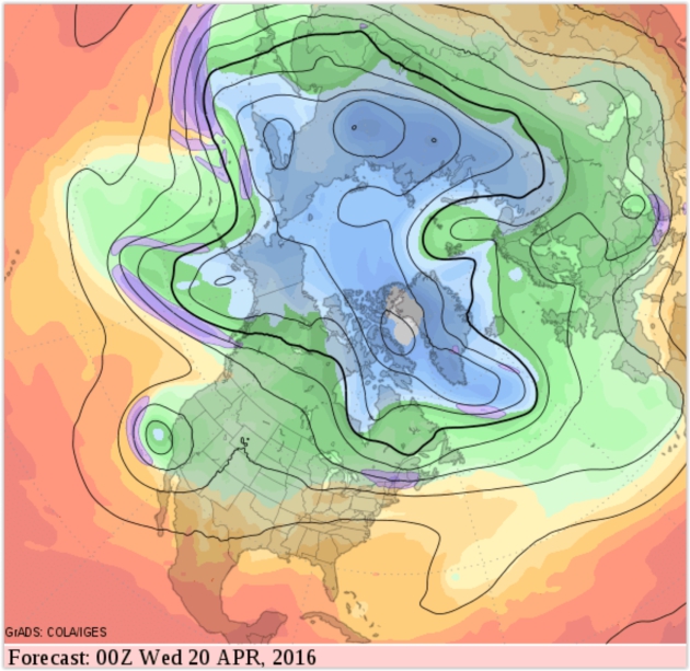
Last Month Was The Hottest March in the Global Satellite Record, and the Arctic is Still Sizzling. Here's an excerpt at ThinkProgress: "...The NSIDC has a metric for how warm (or cold) the Arctic has been called “freezing degree days” (FDDs). Their website explains:
Graphic credit above: "In the Arctic, 2016 (bottom red line) has been anomalously warm."
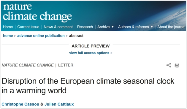 Summer in March? Warming Climate Alters Europe's Seasons. Here's an excerpt from National Geographic: "Earth’s
seasonal clock is out-of-whack. Summers in Europe are coming ten
days ahead of schedule, and could be up to 20 days early by century’s
end if the current pace of carbon emissions continues, according to a new study
by French scientists published Monday. And it’s not just Europe. Trees
leafing out sooner, birds shifting migrations and butterflies arriving
early provide evidence of climate change altering seasonal weather
conditions across the Northern Hemisphere. Europe's first day of summer
conditions has moved up 10 days over the past four decades, according
to the study published in Nature..."
Summer in March? Warming Climate Alters Europe's Seasons. Here's an excerpt from National Geographic: "Earth’s
seasonal clock is out-of-whack. Summers in Europe are coming ten
days ahead of schedule, and could be up to 20 days early by century’s
end if the current pace of carbon emissions continues, according to a new study
by French scientists published Monday. And it’s not just Europe. Trees
leafing out sooner, birds shifting migrations and butterflies arriving
early provide evidence of climate change altering seasonal weather
conditions across the Northern Hemisphere. Europe's first day of summer
conditions has moved up 10 days over the past four decades, according
to the study published in Nature..."
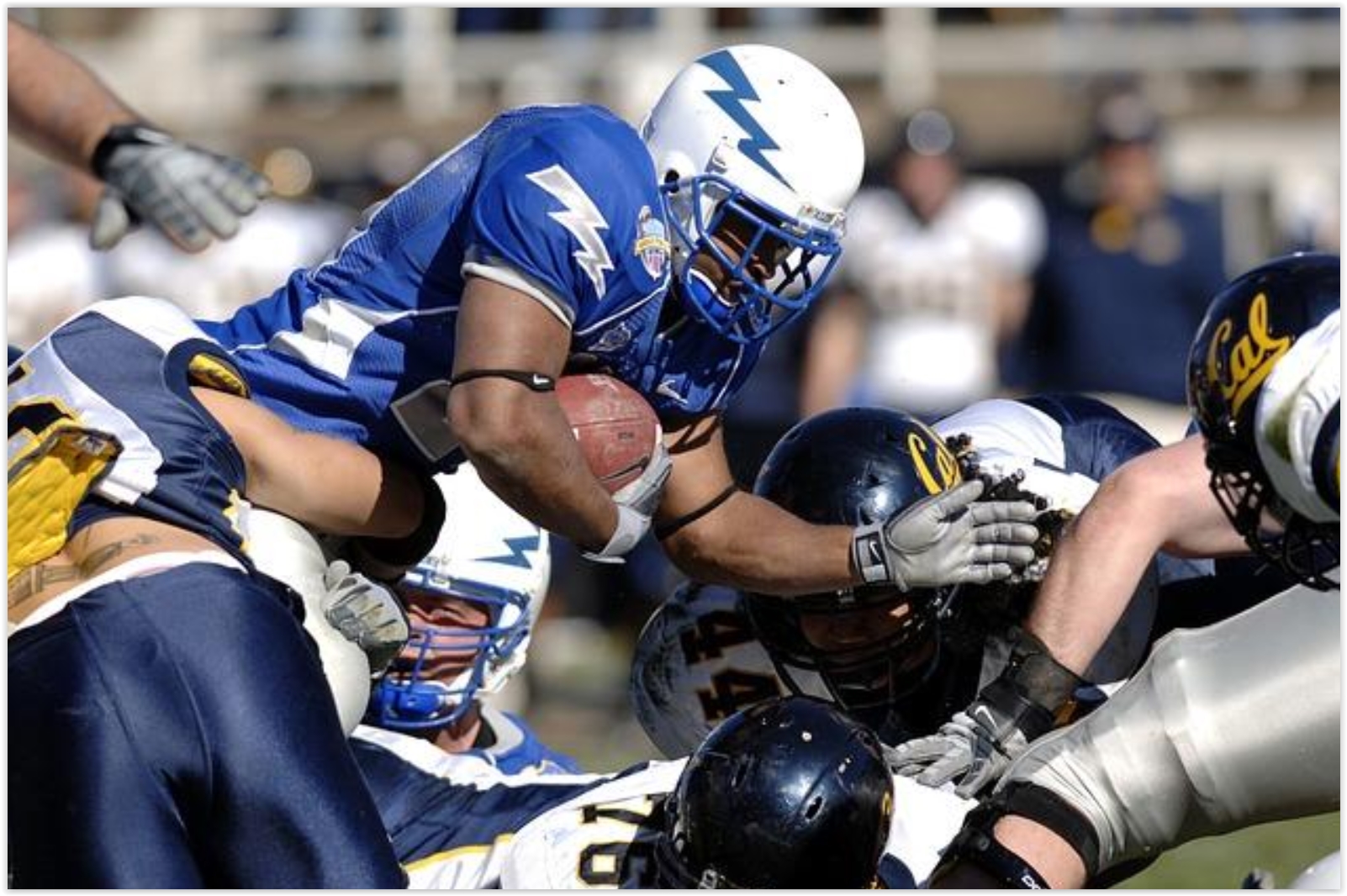
In Cold Weather, NFL Players Have a 2-Fold Greater Risk for Concussions. Medical Daily has a summary of recent research; here's an excerpt: "Researchers from St. Michael’s Hospital in Canada collected and analyzed data collected for each week over the 2012-2013 and 2013-2014 sports seasons for all 32 National Football League (NFL) teams. They found that NFL players had a two-fold greater risk of concussions and a 1.5 times higher risk for ankle injuries when they played in colder weather. According to the study, the higher rates of concussions and injuries occurred when during games played in 50 degrees Fahrenheit or colder when compared with games played in temperatures of about 70 degrees Fahrenheit and higher..."
File photo: Pixabay.
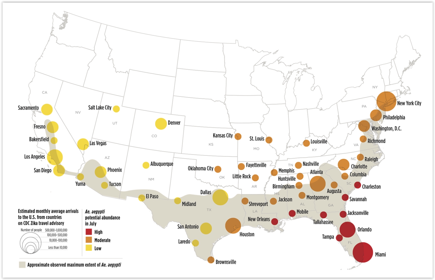
Springtime in D.C. Means Mosquitoes - and Zika. There's a comforting thought; here's an excerpt from Foreign Policy: "...Recently, the National Center for Atmospheric Research (NCAR) published a probability map for the potential spread of Zika, based on U.S. rain and mosquito patterns. Not surprisingly, the cities at highest risk were identified as those in Florida, Louisiana, Mississippi, Georgia, and the Carolinas, where summers are hot, wet, and mosquito-dense. Using the weather-based projections, we (Research Associate Gabriella Meltzer and myself at the Council on Foreign Relations) examined recent histories of mosquito-borne disease, net budgets for insect control, and estimated per capita spending on abatement in each high-risk area..."
The relationship between thermodynamics and sea ice thickness can be thought of most simply in terms of freezing degree days (FDD), which is essentially a measure of how cold it has been for how long. The cumulative FDD is simply daily degrees below freezing summed over the total number of days the temperature was below freezing.NSIDC scientist Andrew Slater has an amazing chart on his website of freezing degree days in 2016 compared to other years at 80 degrees north latitude..."
Graphic credit above: "In the Arctic, 2016 (bottom red line) has been anomalously warm."
In Cold Weather, NFL Players Have a 2-Fold Greater Risk for Concussions. Medical Daily has a summary of recent research; here's an excerpt: "Researchers from St. Michael’s Hospital in Canada collected and analyzed data collected for each week over the 2012-2013 and 2013-2014 sports seasons for all 32 National Football League (NFL) teams. They found that NFL players had a two-fold greater risk of concussions and a 1.5 times higher risk for ankle injuries when they played in colder weather. According to the study, the higher rates of concussions and injuries occurred when during games played in 50 degrees Fahrenheit or colder when compared with games played in temperatures of about 70 degrees Fahrenheit and higher..."
File photo: Pixabay.
Springtime in D.C. Means Mosquitoes - and Zika. There's a comforting thought; here's an excerpt from Foreign Policy: "...Recently, the National Center for Atmospheric Research (NCAR) published a probability map for the potential spread of Zika, based on U.S. rain and mosquito patterns. Not surprisingly, the cities at highest risk were identified as those in Florida, Louisiana, Mississippi, Georgia, and the Carolinas, where summers are hot, wet, and mosquito-dense. Using the weather-based projections, we (Research Associate Gabriella Meltzer and myself at the Council on Foreign Relations) examined recent histories of mosquito-borne disease, net budgets for insect control, and estimated per capita spending on abatement in each high-risk area..."
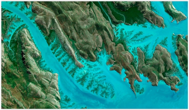
What Happens When You Combine Satellite Imagery and Artificial Intelligence. Fortune has an interesting story - here's a link and excerpt: "...Orbital
Insight, another Silicon Valley geospatial data company, tracks
national and global trends as well as more esoteric indicators, such as
where all the world’s surface water is at any given time, which holds
significant interest for scientists and the global insurance industry.
Descartes Labs, of Los Alamos, N.M., uses satellite data to predict the
yield of U.S. corn harvests, often more accurately than the Department
of Agriculture. And where logging companies previously used samples to
estimate the number of trees in an area of forest, DigitalGlobe taps its
software to count trees, one by one, across millions of acres of
forest..." (Image credit: Digital Globe).


TODAY: Showers linger - still raw. Winds: NW 15-25. High: 48
WEDNESDAY NIGHT: Sprinkles taper, chilly. Low: 34
THURSDAY: Rain mixes with a little snow. Foul. Winds: NW 10-15. High: 42
FRIDAY: Harsh wind, few flurries around. Winds: NW 15-30+ Wake-up: 31. High: 36
SATURDAY: Sunnier, easier to take. Winds: SE 10-15. Wake-up: 26. High: 43
SUNDAY: Another round of rain showers likely. Winds: SW 10-20. Wake-up: 36. High: 55
MONDAY: Mostly cloudy, turning colder again. Winds: NW 15-25. Wake-up: 34. High: 42
TUESDAY: More clouds than sun. Take a jacket. Winds: NW 10-15. Wake-up: 27. High: near 40
Climate Stories....

Which Countries Are Most At Risk of Climate Change and How Can We Help? Here's the intro to a story at IRIN: "The countries most vulnerable to climate change are among the poorest and least able to respond. How to resolve that dilemma and help these places adapt to a warming world remains among the knottiest problems facing climate financing. The good news is that identifying those most in need – step one – is now a good deal easier thanks to a global league table developed by the University of Notre Dame. The Notre Dame Global Adaptation Index (ND-GAIN) measures a country’s vulnerability in relation to its ability to cope with climate change..."


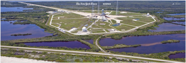
NASA Is Facing a Climate Change Countdown. Here's a snippet from a New York Times article: "...This
is America’s busiest spaceport, and the water is coming. Like so much
of Florida, the Space Coast — a 72-mile stretch along the Atlantic — is
feeling the threat of climate change. Some of the erosion is caused by the churning energy of ocean currents along the coastline. Hurricane Sandy, whose power was almost certainly strengthened
by climate change, took a big bite in 2012, flattening an already
damaged dune line that provided protection from the Atlantic’s
battering. A rising sea level will bring even greater risk over time —
and perhaps sooner than most researchers expected. According to a study published last week,
warming pressure on the Antarctic ice sheet could help push sea levels
higher by as much as five or six feet by the end of this century..."
Photo credit above: "The refurbished Launch Complex 39B at Kennedy Space Center, which is on the ocean and surrounded by marshland, in 2013." Credit Kim Shiflett/NASA.
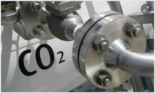
Photo credit above: "Carbon disposal consists chiefly of the burial of carbon dioxide in underground caverns, known as carbon capture and storage (CCS)." Photograph: Sipa Press / Rex Features
Climate Catastrophe, Coming Even Sooner? I
realize (many) people shut down and tune out when they hear a story
like this. "There's nothing we can do - so why do anything?" The reality
is that there may still be time to avoid a worst-case scenario of
Antarctic and Greenland ice melt, but the clock is ticking, and has been
for the last few hundred years as greenhouse gases have ramped up in
the atmosphere. Here's an excerpt of an Elizabeth Kolbert story at The New Yorker: "...The
latest example comes from a study published Wednesday, in the journal
Nature. “Antarctic Model Raises Prospect of Unstoppable Ice Collapse,”
ran the headline in the news story
that accompanied it. The new paper, coauthored by Rob DeConto, of the
University of Massachusetts at Amherst, and David Pollard, of
Pennsylvania State University, arose out of frustration. The two
researchers had spent years working on a computer model that did not
seem to capture rises in sea level that were already known to have taken
place. Before the last ice age, about a hundred and twenty thousand
years ago, for instance, sea levels were at least twenty feet higher
than they are now. But DeConto and Pollard found that unless they
programmed the model with temperatures that were unrealistically high
for that period it could not account for such levels..."
Photo credit above: "New
research indicates that, due to global warming, the West Antarctic Ice
Sheet (WAIS) may be headed for an unavoidable and disastrous collapse,
triggering a rapid rise in sea levels." Credit Photograph by Natacha Pisarenko/AP.

Image credit above: "The economic impact of climate change could play havoc with the world economy, according to an LSE study." Photograph: Carlo Allegri/Reuters
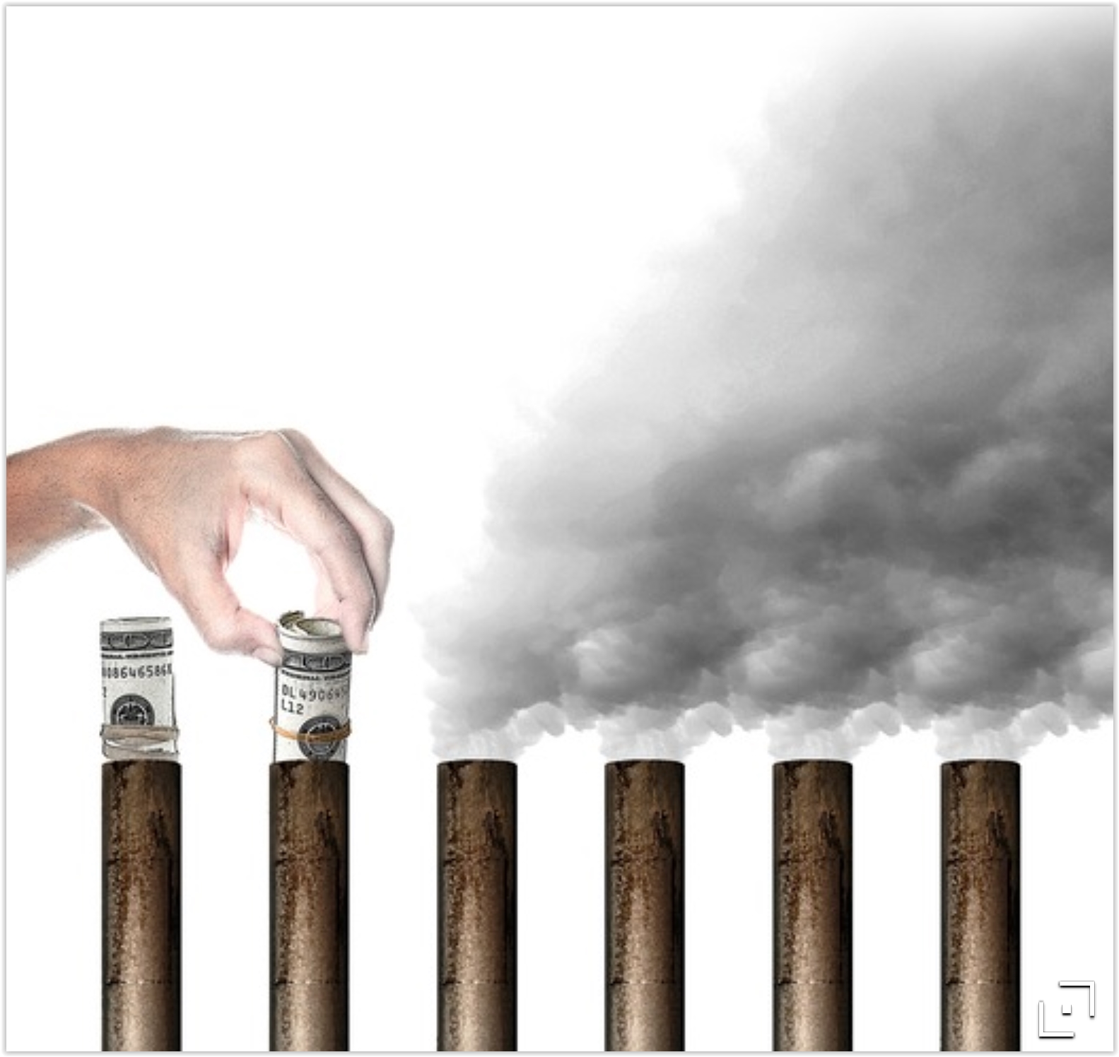
How To Fight Climate Change? Put a Price on Pollution.
We've done it before - it works. British Columbia has had a
revenue-neutral tax on carbon since 2008 and the Canadian province is
booming, economically. Here's an excerpt of an Op-Ed at The Star Tribune: "...The
risks of climate change may be uncertain, but actuaries price risk for
insurance companies — an approach that could be adopted for gauging the
cost-benefit calculation on limiting CO2 emissions. “Cap and trade” is
an antipollution strategy that already has worked. In the days when
Congress actually passed legislation, a law set limits on sulfur dioxide
emissions that created the bane of “acid rain” in the 1970s. Result: A
cap-and-trade program that reduced that pollutant by 85 percent. It cost
about $3 billion but yielded benefits of $167 billion to $427 billion —
effectively relegating “acid rain” to the dustbin of history.
Economists making the dollars-and-cents case for action on climate
change already often find themselves outside their comfort zone..."
Graphic credit: Star Tribune.

We've Been Getting These Key Details About Greenland's Melting All Wrong. It's not just surface temperature increases and carbon soot accelerating melting of ice; it's also surrounding water. The Washington Post reports; here's an excerpt: "...It’s also believed that warm ocean water can help destabilize glaciers from the bottom up, melting the ice where it’s grounded to the seafloor and eventually causing large chunks to break away. Truffer pointed out that it’s “only in the last 10-plus years that people really started realizing how much of a role melting by ocean water played.” So scientists are still getting a handle on the kinds of information we need to really understand the process. And one under-studied part of the picture is underwater topography..."
No comments:
Post a Comment