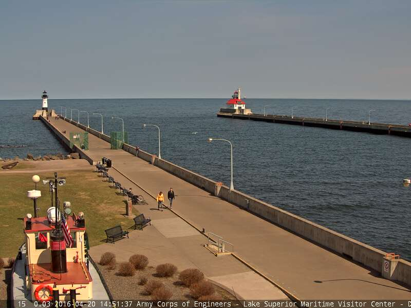
While much of the state ducked in and out of clouds on Wednesday, Duluth enjoyed lots of sunshine thanks to a fairly stout lake breeze! Sure, there's was lots of sunshine, but it was MUCH cooler by the lake! While the temperature over the hill was reporting a temperature around 60F by 3pm, it was nearly 20F colder by the lake in Downtown Canal Park.
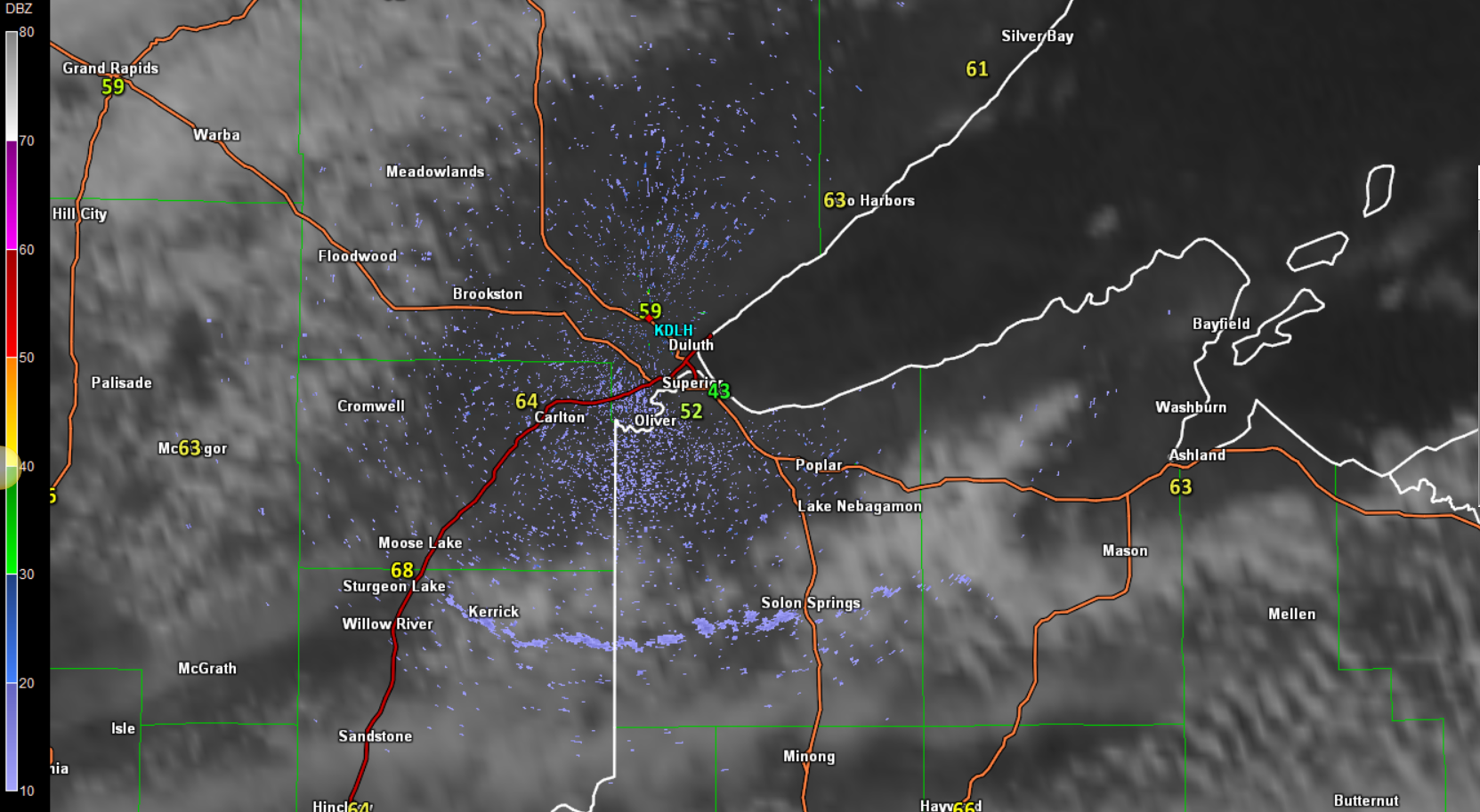
Duluth Radar
This was the radar around 3pm Wednesday, which actually showed a lake breeze being picked up by radar. Note the thin blue line stretching from near Sturgeon lake on I35 in MN to Solon Springs in WI. While radars are generally used to 'see' precipitation, it can often pick up other things like dust, birds and smoke plumes. It can also pick up lake breezes. Here's a better explanation from the NWS out of Milwaukee following a lake breeze event they had a while back.
"This creates an area of convergence. Because of this convergence, small particles (such as dust and vegetation debris) along with biological targets (like insects) get collected right along the lake breeze. Our radar can sometimes see these targets, and thus the lake breeze shows up as a thin line of reflectivity. In addition, the air mass behind the lake breeze has different properties than the air out ahead of it. This creates a density discontinuity along the lake breeze, which can affect the radar beam and return energy back to the radar. These combined effects are why we can often see lake breezes with our radar."
Read more about it HERE:
Visible Satellite Wednesday
Take a look a the visible satellite image from Wednesday. Note that toward the end of the loop there seems to be a lake superior shape in the clouds surrounding the western half of the lake. This is due to the cooler air being pushed inland; it creates a more stable airmass, which clouds have a harder time developing in. Pretty neat, huh?

Two Steps Forward, One Step Back
By Todd Nelson, filling in for Douglas
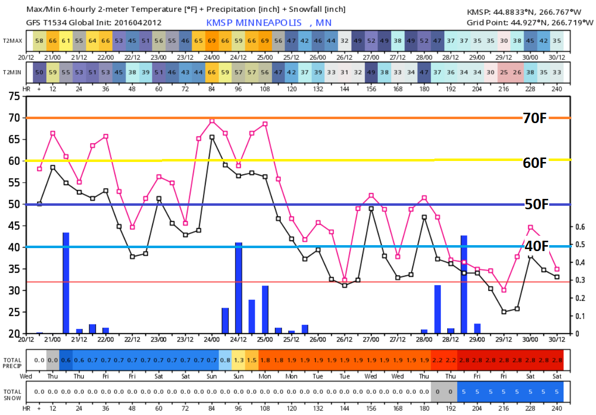
Shirley from Hanover, MN recently asked me, "Todd, we're done with the cold and snowy weather, right?" HA! Well, I'm sure your sentiments are echoed by many. I wish I could tell you that the weather will be in your favor for the next 6 weeks until meteorological summer starts (June 1st), but inevitably we will stumble upon a less desirable stretch of weather before then.
One of those stretches may already be in the works for next week. Weather maps look colder and perhaps even a little wintry! Keep in mind that the average Twin Cities snowfall for April is around 2.5 inches. We've only seen 0.5 inch so far. Interestingly, April 2013 saw 17.9 inches of snow! Good grief.
Don't worry, the odds of significant snow are dwindling rapidly and if we see anything over the coming weeks, it will melt fast.
I am happy to report that 60s to near 70 degree weather will be with us through Sunday. A storm system arrives this weekend with a few showers worthy of rumbles. Jacket-worthy temps return next week with highs in the 40s and 50s.
_____________________________
Extended Forecast
WEDNESDAY NIGHT: Mostly cloudy, showers likely. Winds: NE 5-10. Low: 51
THURSDAY: AM sprinkle, slow PM clearing and breezy. Winds: NNW 10-15. High: 65.
THURSDAY NIGHT: A few sprinkles early, otherwise clearing. Winds: N 10-15. Low: 41
FRIDAY: Bright sun, less wind. Winds: ESE 5. High: 60
SATURDAY: Breezy and warm PM. Late day rumble? Winds: ESE 10-15. Wake-up: 46. High: 70.
SUNDAY: Scattered showers with rumbles of thunder. Winds: ENE 10-15. Wake-up: 54. High: 65.
MONDAY: Soggy with a cool breeze. Winds: ENE 10-15. Wake-up: 46. High: 55.
TUESDAY: Breezy and cooler. Clouds thicken late. Winds: ESE 10-15. Wake-up: 39. High: 57.
WEDNESDAY: Cold rain develops. Wintry mix up north? Winds: SE 10-15. Wake-up: 37. High: 54.
________________________________
This Day in Weather History
April 21st
1910: A snowstorm hits northeastern Minnesota. Duluth picks up 6.5 inches.
________________________________
Average High/Low for Minneapolis
April 21st
Average High: 61F (Record: 95F set in 1980)
Average Low: 40F (Record: 22F set in 1966)
_________________________________
Sunrise/Sunset Times for Minneapolis
April 21st
Sunrise: 6:17am
Sunset: 8:06pm
*Daylight gained since yesterday: ~2mins & 55secs
*Daylight gained since winter solstice: ~5hours & 3mins
__________________________________
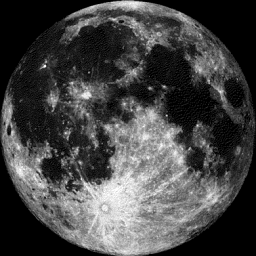
Full (PINK) Moon at 12:24am CDT April 22nd
"April 22, 12:24 a.m. CDT — The Full Pink Moon. The kind of grass that is called pink or wild ground phlox is one of the earliest, widespread flowers of the spring. Other names for this same moon were the Full Sprouting Grass Moon, the Egg Moon and — among coastal tribes — the Full Fish Moon, when the shad came upstream to spawn."
See more from Space.com HERE:
________________________________________
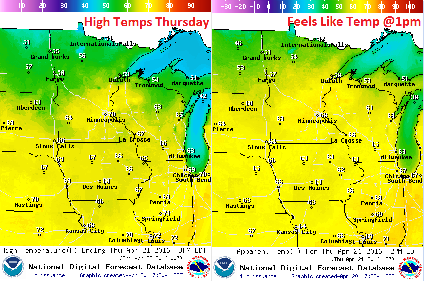
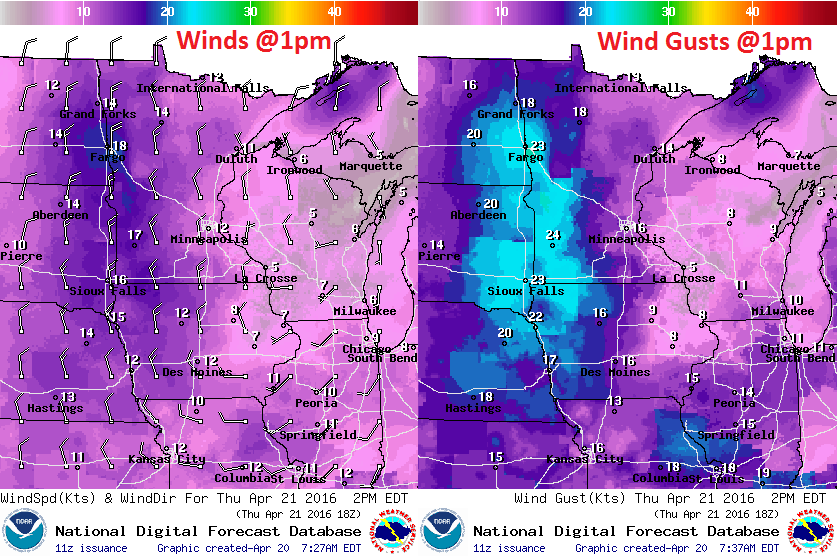
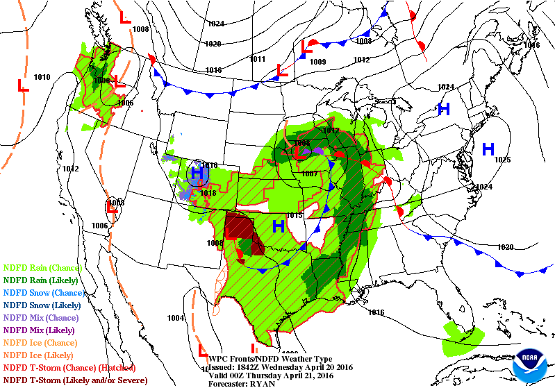
Thursday Weather Outlook
High temperatures on Thursday will be fairly mild once again, mainly early and across the southern part of the state. A cool front approaching quickly from the northwest will help to drop temperatures through the day. Highs in northern Minnesota might even struggle to make it to 50F
Thursday Weather Outlook
Winds around midday Thursday will be a little on the breezy side. This will be post front, which will help to pull moisture farther south through the rest of the day.
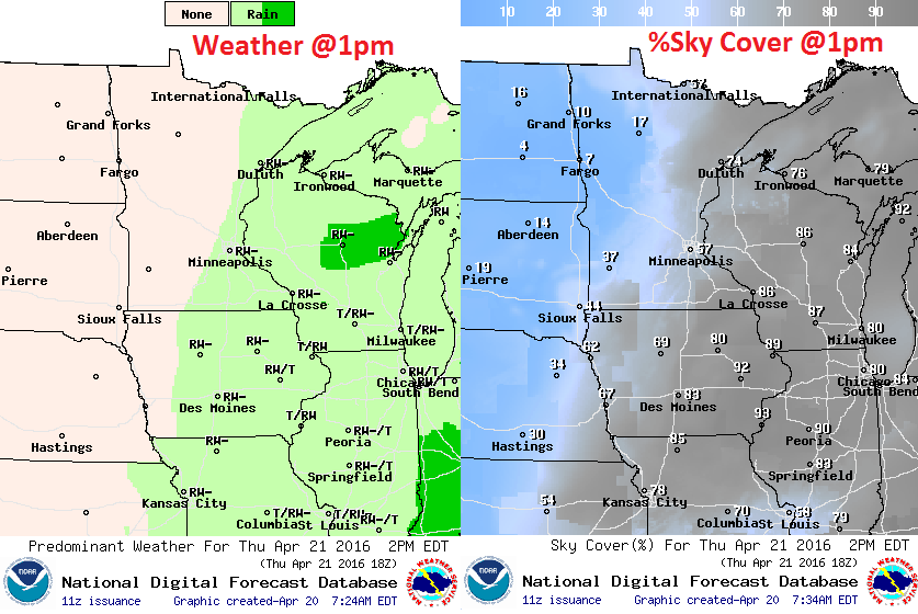
Thursday Weather Outlook
Weather conditions midday Thursday could still be a bit on the unsettled side, however, the best chance of precipitation will be shoved southeast as the cool front pushes the moisture that way. Note the clearing taking place farther west, this is the drier, sunnier weather expected for Friday.
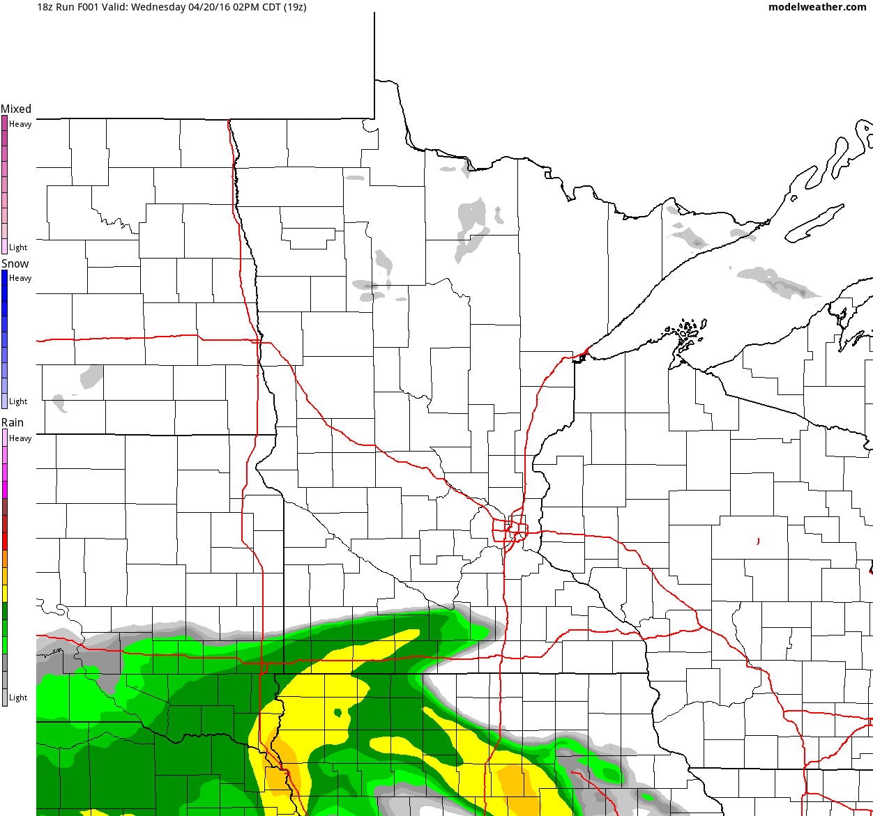
Simulated Radar
Here's the simulated radar from midday Wednesday thru Friday night. It shows the band of precipitation that moved up from Iowa during the day Wednesday. Note that it doesn't appear to make it much farther north during the day Thursday before another quick moving band of showers along a cool front comes sailing in form the north. The passage of the cool front will bring drier, cooler weather to the region on Friday.
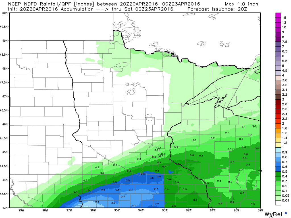
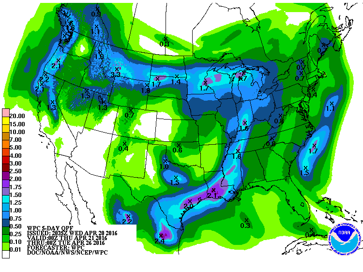
Precipitation Outlook
The precipitation outlook from midday Wednesday to 7pm Friday shows pockets of heavier rain across the southern part of Minnesota associated with the rainfall that moved up from Iowa during the day Wednesday. Most of the accumulating moisture will quickly fade and exit the region during the day Thursday. Friday will be a dry day across the state.
___________________________
Extended Weather Outlook
While we've been enjoying milder temperatures as of late, we might not want to get too comfortable just yet. Sure, the forecast into the weekend suggests more 60s to near 70F through the weekend, but look at what happens next week! It appears that we may see a few more highs in the 40s and 50s with cold rain chances developing at times... Dare I say the "S" word? Stay tuned as the last week of April approaches.
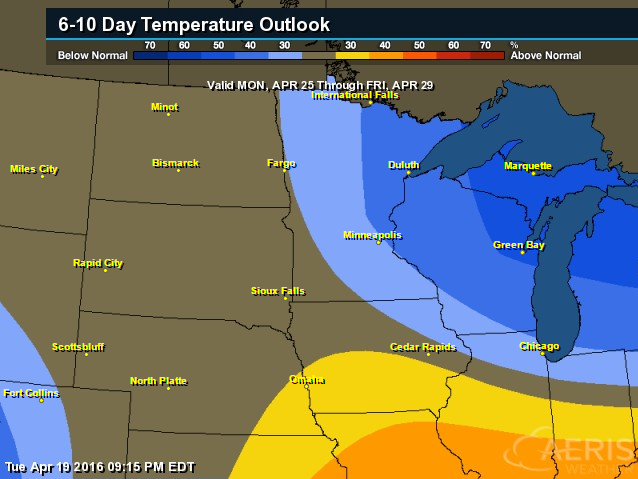
6 to 10 Day Temperature Outlook
According to NOAA's CPC, the 6 to 10 day temperature outlook suggests a good chance of cooler than average temperatures moving in next week. Some of the extended forecasts are suggesting highs in the 50s, potentially even 40s, which would be well below average. Keep in mind that the average high for the Twin Cities is ~60F now.
_____________________________
National Weather Outlook
So long stubborn low pressure system... The area of low pressure that dumped nearly 50" of snow near Pinecliffe, CO and flooded Houston, TX with 9.92" of rain Monday (2nd wettest day in the cities history) is finally starting to move quicker. It will get a hastier push east thanks to a cold front dropping through the Midwest Thursday. In its wake, drier weather will be in place over the next few days, but a developing storm system in the Western U.S. could bring more interesting weather back the the Central U.S. next week.
5 Day Precipitation Outlook
According to NOAA's WPC, the 5 day precipitation forecast suggests heavier rainfall potential still in the Southern U.S. near Houston, TX, which could lead to additional flooding, but also notice the narrow swath of some 1" tallies across the northern tier of the nation. There are some indications that temperatures could be cold enough for wintry precipitation in some areas... stay tuned!
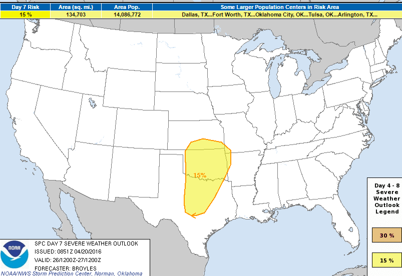
Severe Threat Next Week?
On Wednesday, April 20th, NOAA's SPC issued a DAY 7 severe threat, for severe weather concerns next week. Interestingly, this is only the 12th time since 2008 that a DAY 7 has been issued, which means the confidence is pretty decent that strong/severe storms may develop next week.
BOTH SOLUTIONS MOVE A SHORTWAVE RIDGE NEWD ACROSS THE SRN
   AND CNTRL PLAINS MONDAY INTO MONDAY NIGHT AND SHOW AN UPPER-LEVEL
   TROUGH APPROACHING THE SRN PLAINS ON TUESDAY/DAY 7. THE MODELS
   SUGGEST A DRYLINE ORGANIZES ACROSS THE SRN PLAINS DURING THE DAY ON
   TUESDAY WITH THUNDERSTORMS DEVELOPING ALONG AND EAST OF THE DRYLINE
   LATE TUESDAY AFTERNOON. THE ECMWF SOLUTION ALSO SHOWS THE EXIT
   REGION OF A MID-LEVEL JET OVERSPREADING THE SRN PLAINS ON TUESDAY.
   THE MODELS ARE IN GENERAL AGREEMENT AND HAVE SHOWN ENOUGH RUN TO RUN
   CONSISTENCY TO ADD A 15 PERCENT CONTOUR FOR PARTS OF CNTRL AND NORTH
   TX...OK...SRN KS...NW AR AND FAR SW MO FOR TUESDAY AND TUESDAY
   NIGHT. A SEVERE WEATHER EVENT WITH TORNADOES...LARGE HAIL AND WIND
   DAMAGE WILL BE POSSIBLE.
_______________________________
Monarch Butterfly Population Surges in Mexico
Well, here's a good story from earlier this year about our friends the Monarch Butterfly from Discovery.com:
"The
monarch butterfly population has soared in its Mexican winter sanctuary
this season, marking a recovery for the threatened species that
migrates across North America. The orange and black butterfly covered
4.01 hectares (9.9 acres) of pine and fir forest in the 2015-2016
season, more than tripling last year’s figure of 1.13 hectares, Mexican,
US and Canadian officials said. While researchers measure the
population by the area it covers, it estimates that there were 140
million butterflies this year in the mountains of central Mexico."
(Image courtesy: Discovery.com via iStockphoto/Thinkstock)

____________________________________________________
Do not flush: New labeling for disposable wipes
Kudos to the MPCA (Minnesota Pollution Control Agency for bringing this up... Those so called 'flushable' wipes are causing a MAJOR issue in the sewer system and the MPCA wants the word 'flushable' banned.
"The
MPCA is seeking a ban on the word “flushable” on the labels of
disposable wipes after dozens of Minnesota communities have reported
that wipes cause costly problems for their wastewater systems. Disposable
wipes — used for changing diapers, personal hygiene, housecleaning and
more — cause major problems when flushed down toilets. Because they
don’t break down the way toilet paper does, these wipes clog homeowner
and municipal sewer pipes, put stress on community wastewater collection
and treatment equipment, and cause cities to spend thousands on
clearing clogs and premature equipment replacement. Wipes
snag on any imperfection in sewer pipes, catch passing debris and
grease, and create a “ball” that will grow to plug the pipe.
Municipalities must manually clean screens or remove clogs."
See the full story from the MPCA HERE:
(Photo courtesy: MPCA)

_______________________________
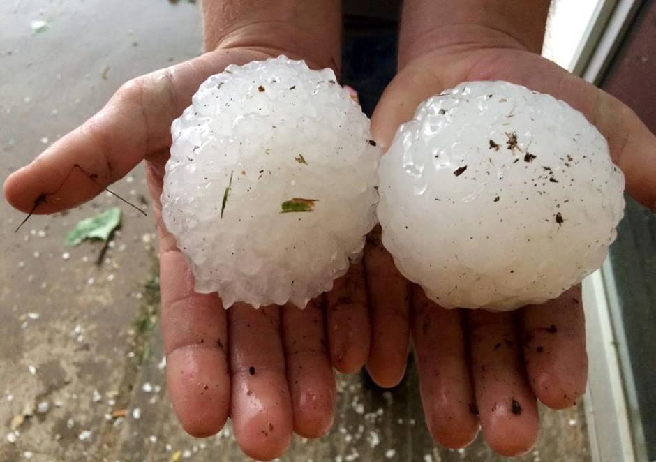
Dallas County Among Texas' Top Three in Hail, Wind Damaging Claims
"When it comes to hail and wind damage, Dallas County seems to be one of Texas' top spots to unsuccessfully weather the storm. In a county-by-county analysis of the state by Allstate, only Randall County in the panhandle and Bell County in Central Texas have had a higher frequency of wind and hail insurance claims from 2011-2015 than Dallas County. Other North Texas counties have paid the price for Mother Nature's falling ice. Johnson, Ellis, Denton, Parker, Kaufman and Collin all make the top 10 of Texas counties with damage claims, and Tarrant sits at No. 11."
(Ben McMillan/Special to DMN)
_____________________________
Thanks for checking in and have a great rest of your week!
Follow me on Twitter @TNelsonWX

See the full story from the MPCA HERE:
(Photo courtesy: MPCA)
_______________________________
Dallas County Among Texas' Top Three in Hail, Wind Damaging Claims
"When it comes to hail and wind damage, Dallas County seems to be one of Texas' top spots to unsuccessfully weather the storm. In a county-by-county analysis of the state by Allstate, only Randall County in the panhandle and Bell County in Central Texas have had a higher frequency of wind and hail insurance claims from 2011-2015 than Dallas County. Other North Texas counties have paid the price for Mother Nature's falling ice. Johnson, Ellis, Denton, Parker, Kaufman and Collin all make the top 10 of Texas counties with damage claims, and Tarrant sits at No. 11."
(Ben McMillan/Special to DMN)
_____________________________
Thanks for checking in and have a great rest of your week!
Follow me on Twitter @TNelsonWX
No comments:
Post a Comment