I have to admit that seeing stuff pop out of the ground after the long Minnesota winter is certainly a sight for sore eyes! The recent mild weather had me snooping around the garden on Friday. I peeled away the leaves and to my surprise rhubarb and strawberry plants are already well on their way this growing season! Grow plants grow!!

Springy Looking Satellite
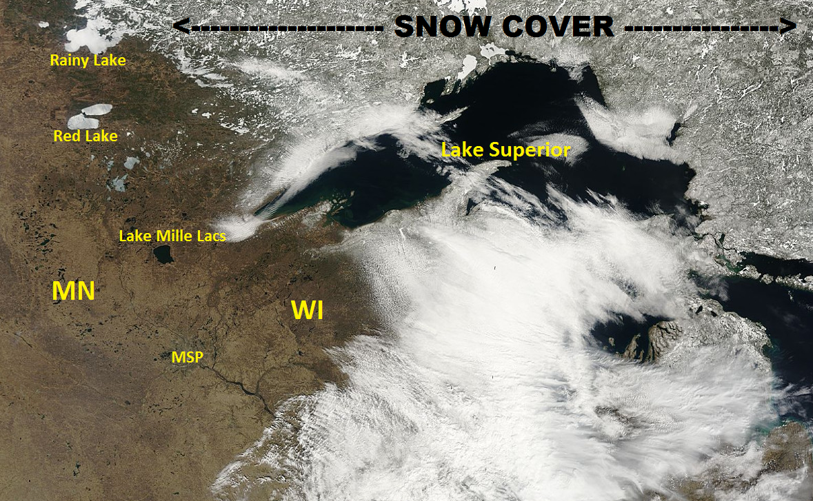
One of my favorite things to look at is a visible satellite. The image from nearly 23,000 miles above the Earth's surface on Wednesday, April 13th showed several interesting features across the Western Great Lakes. Note that much of Minnesota is now snow free with the exception of the Arrowhead. Much more snow cover can be found north of Lake Superior. You can also see that Lake Mille Lacs is ice free, but some of the larger lakes farther north like Red and Rainy are still ice covered.
Visible satellite from Wednesday, April 13th
Minnesota Ice Outs
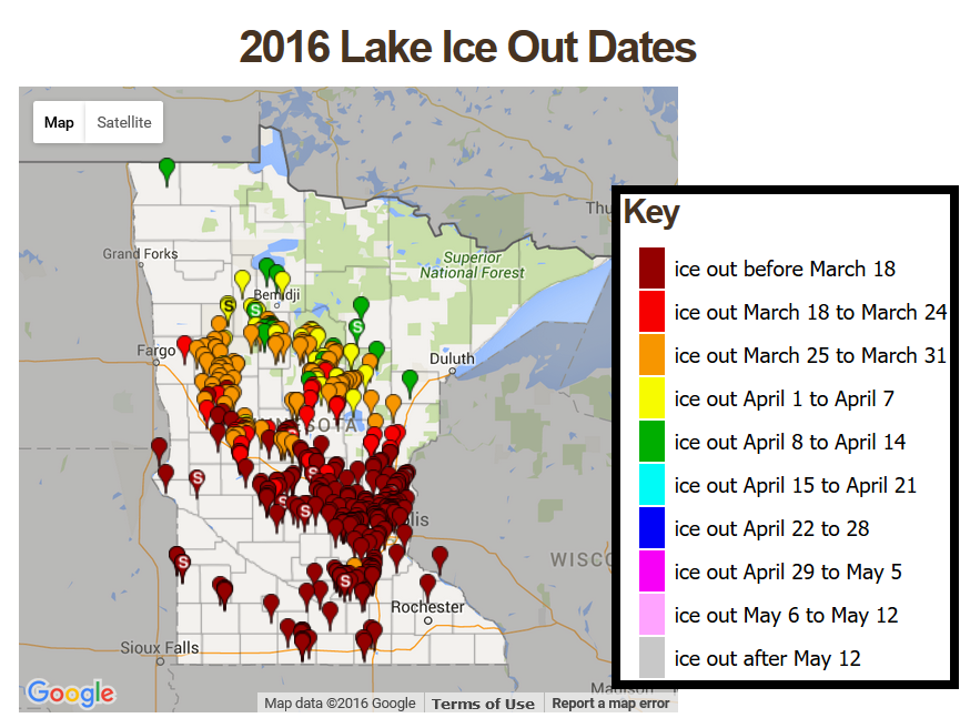
According to MN DNR, most of the lakes across the southern two-thirds of the state were considered to be ice free! Note that we are seeing ice outs nearly 1 to 2 weeks earlier than average thanks to the mostly mild weather so far this spring!
See more from the MN DNR HERE:
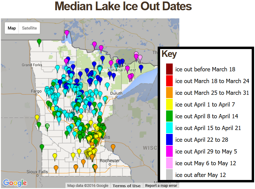
Average Ice Out Dates
____________________________
Warm and breezy. Feels more like late May
By Todd Nelson, filling in for Douglas
The recent mild weather has my green thumb going crazy. Whether it's tilling the garden, planting some cold weather crops or just gazing at budding trees and rhubarb stems bursting through the ground, I've got the itch. Keep in mind that we're still a good month or more away from putting most plants in the garden; a good rule of thumb is Memorial Day.
Our windy warm up is the result of a slow moving storm system over the Central Rockies that will continue to produce loads of snow in the mountains and along the Front Range. Denver, CO could see nearly 1 foot of heavy, wet snow and folks in the Plains could see as much as 3 to 6 inches of rain and flooding by the end of the weekend. For us, It looks like we'll be far enough east to reap the benefits of a mostly dry and mild weekend.
As the storm slowly slides our way, weather conditions will sour slightly. Clouds will be on the increase with a few spotty showers possible late weekend. Slightly better chances of rain and rumbles don't arrive until early next week.
Enjoy the warmth!
_____________________________
Extended Forecast
SATURDAY: Warm sun and breezy. Few T-storms western MN. Winds: S 10-20. High: 74
SATURDAY NIGHT: Mostly cloudy. Winds: S 5-10. Low: 56.
SUNDAY: Still mild, stray PM shower or rumble of thunder possible. High: 73. Winds: SSW 8-13.
MONDAY: Spotty shower or t-shower. Winds: ESE 10-15. Wake-up: 56. High: 70
TUESDAY: Partly sunny and pleasant. A few showers or rumbles possible. Winds: E 8-13. Wake-up: 48. High: 63.
WEDNESDAY: Still mild. PM sprinkle or shower. Winds: SE 8-13. Wake-up: 47. High: 68
THURSDAY: A shot at 70F again. PM storm north. Winds: S 5-10. Wake-up: 49. High: 70.
FRIDAY: Warm winds. unsettled north. Winds: ESE 5-10. Wake-up: 50. High: 69
________________________________
This Day in Weather History
April 16th
1939: A rain, snow, sleet and ice storm begins across southern Minnesota. Despite many phone and power outages, farmers are jubilant that the storm brings needed moisture.
________________________________
Average High/Low for Minneapolis
April 16th
Average High: 58F (Record: 88F set in 1964)
Average Low: 38F (Record: 10F set in 1875)
_________________________________
Sunrise/Sunset Times for Minneapolis
April 16th
Sunrise: 6:26am
Sunset: 8:00pm
*Daylight gained since yesterday: ~2mins & 59secs
*Daylight gained since winter solstice (December 21st): ~4hours & 48mins
____________________________________
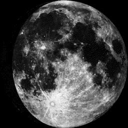
Moon Phase for April 16th at Midnight
3.1 Days Since First Quarter
_____________________________________
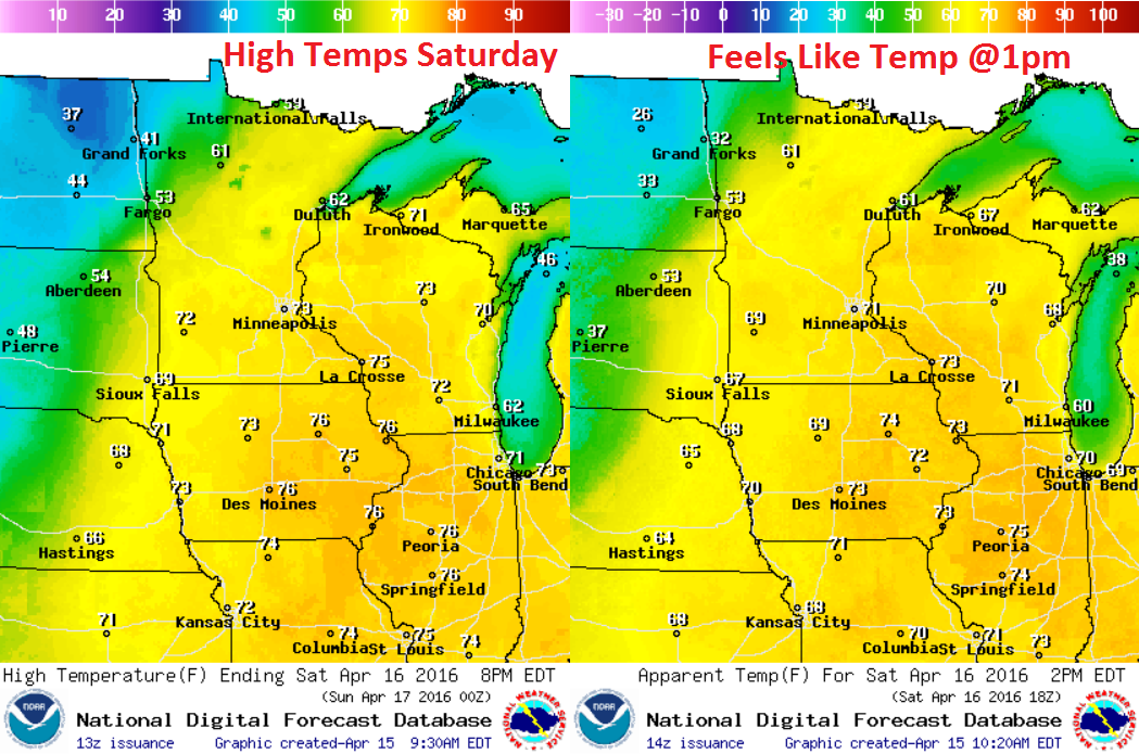
Saturday Weather Outlook
Saturday will be another very mild day across the region with high temperatures near late May/early June standards. Note how cold temperatures will be though in eastern North Dakota! The stalled front located there will help to continue keeping precipitation chances going there and into the northwestern corner of Minnesota. However, with temperatures as cool as they'll be in northeastern North Dakota, areas of slushy snow can't be ruled out.
Saturday Weather Outlook
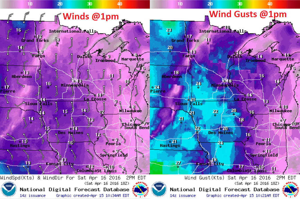
It'll be another breezy day across the region again on Saturday with winds out of the south at 10 to 20mph+ in Minnesota and Wisconsin. Temperatures here will still be running nearly 15F above average, however, winds out of the north across the Dakotas will be a much cooler wind with temperatures running nearly 15F below average there!
Saturday Weather Outlook
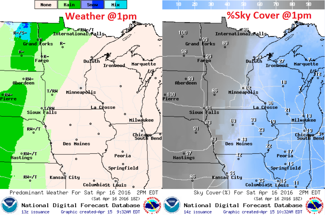
The stalled frontal boundary across the High Plains/Dakotas with be responsible for ongoing showers and rumbles of thunder much of the day Saturday. Also note the wintry mix potential across parts of northeastern North Dakota. It appears that any accumulations would be slushy and very minor. Clouds will also start creeping a little farther east, so it won't be quite as sunny in eastern Minnesota as it was last week.
Simulated Radar
The simulated radar through PM Sunday suggests scattered showers and rumbles of thunder possible Saturday and Sunday across much of the Dakotas, but note that some of that activity looks to sneak into parts of western and northern Minnesota especially during the afternoon/evening hours.
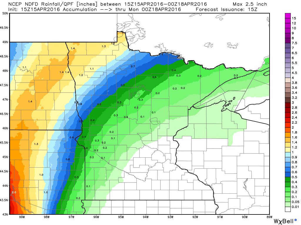
Precipitation Potential
Here's the precipitation potential through 7pm Sunday, which shows the heaviest precipitation values across the Dakotas and northwestern Minnesota where the stalled front will be located through then. A few hit or miss showers will drift into western and northern Minnesota and bring lighter amount of moisture there.
_______________________________
Extended Weather Outlook
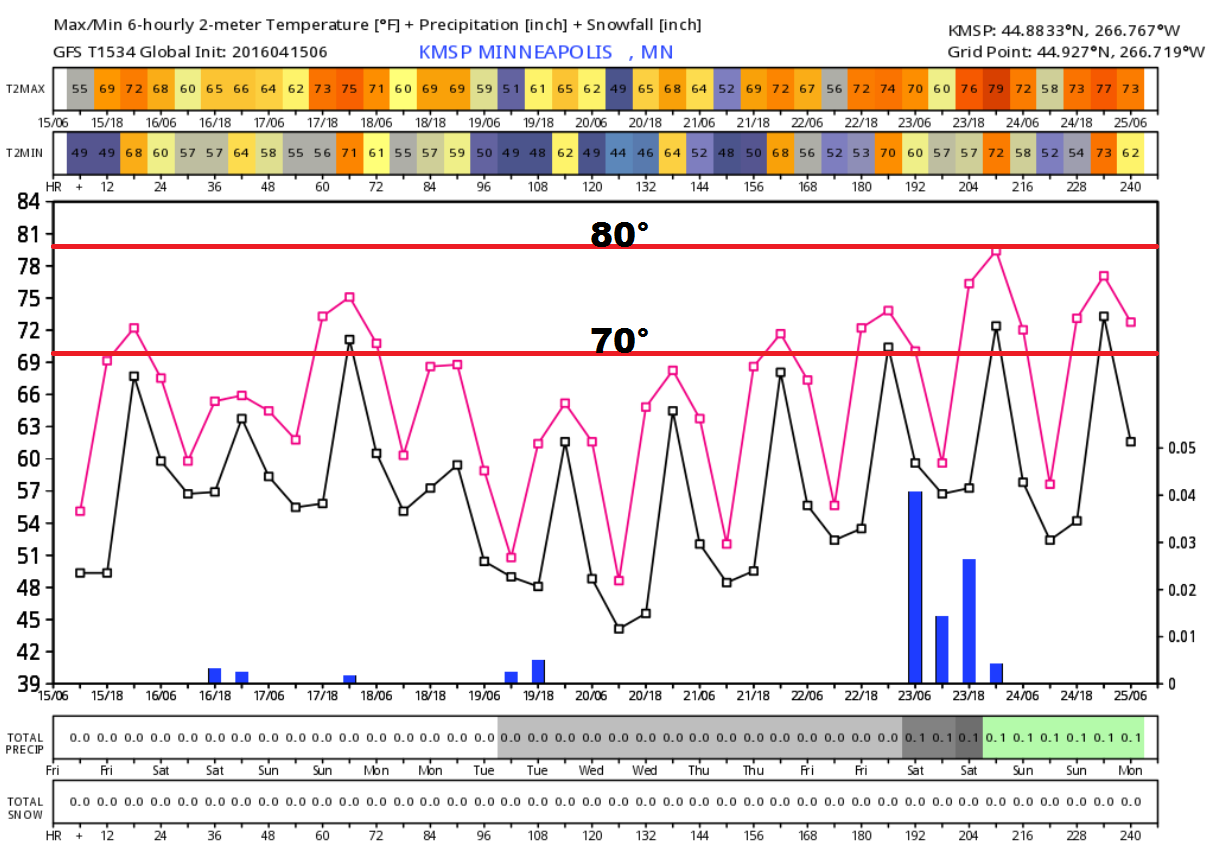
Here's the extended weather forecast for Minneapolis, which shows a stretch of 60s and 70s continuing through the next week and a half. With average highs in the upper 50s to near 60F over this time, temperature readings will likely stay above average. Precipitation values also look to remain fairly minimal over the next week or so.
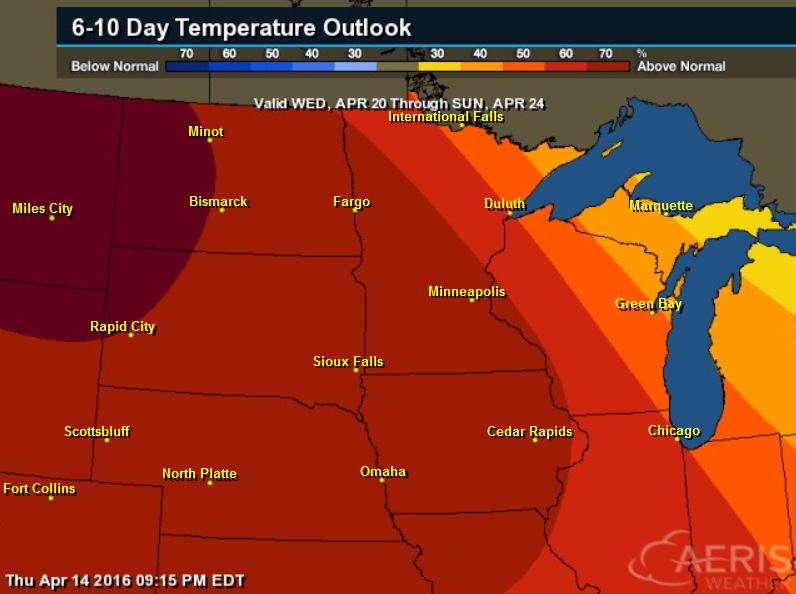
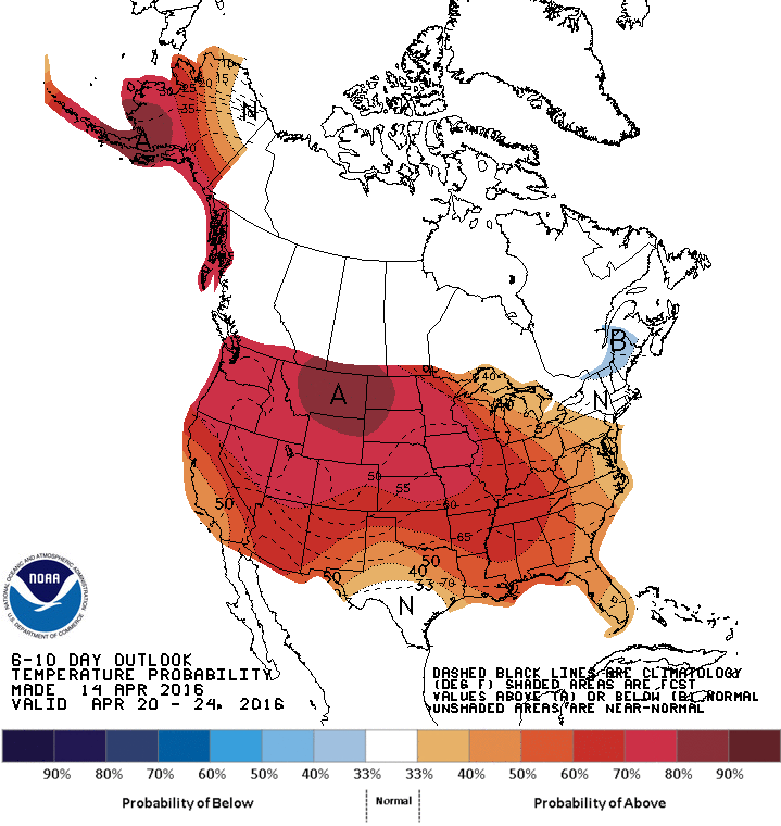
6 to 10 Day Temperature Outlook
If you are enjoying the recent mild weather, it appears that you may get to enjoy it for a while longer. According to NOAA's CPC, the 6 to 10 day temperature outlook shows that there is a good chance of milder than average temperatures continuing into the end of next week/weekend.
____________________________________
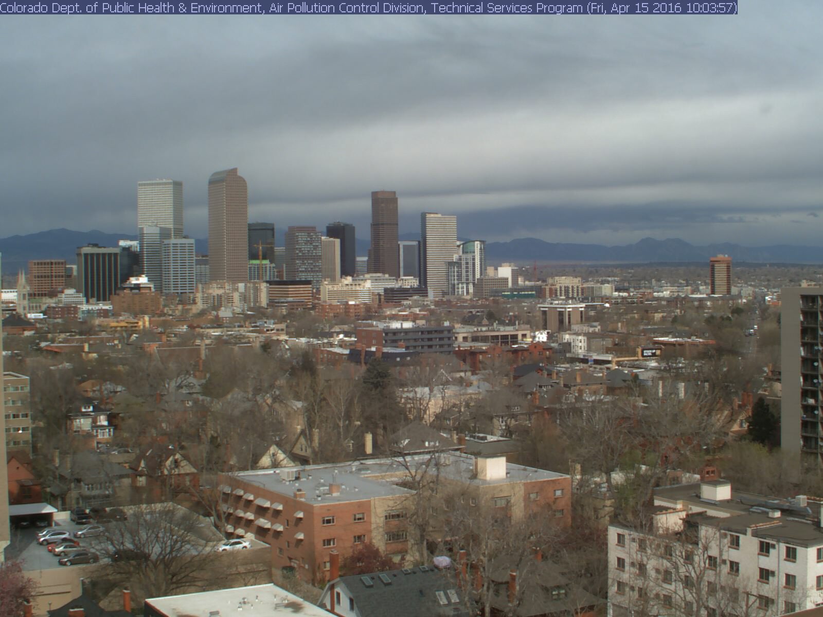
Denver, CO
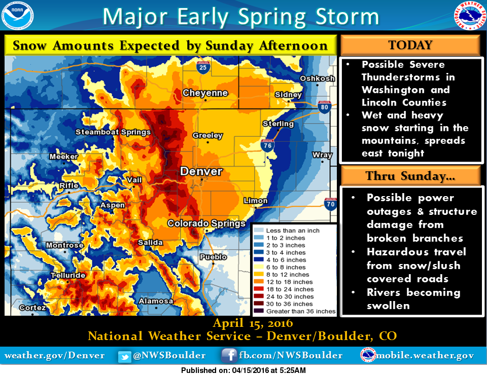
One of the big stories this weekend will be the heavy snowfall event in the Central Rockies and Front Range with feet of snow possible in some areas through Sunday. The view from Denver, CO showed cloudy skies on Friday. Precipitation will turn from rain to snow with the heaviest snowfall occurring on Saturday. Nearly a foot of slushy, wet snow may be possible around the Denver area by Sunday!
See the latest webcam HERE:
Winter Weather Headlines
...STRONG AND POTENT STORM WILL MOVE ACROSS COLORADO THIS
WEEKEND...

.A STRONG STORM SYSTEM ACROSS THE GREAT BASIN FRIDAY MORNING WILL
TRACK SOUTHEAST AND INTENSIFY OVER ARIZONA BY LATE FRIDAY AFTERNOON.
THIS STORM IS THEN EXPECTED TO STALL OVER THE FOUR CORNERS REGION
THROUGH THE WEEKEND AND IMPACT COLORADO WEATHER OVER THE NEXT
SEVERAL DAYS.

THE STORM SYSTEM WILL CONTAIN HIGH AMOUNTS OF MOISTURE AND IS
EXPECTED TO PRODUCE HEAVY AMOUNTS OF SNOW OVER THE FRONT RANGE
FOOTHILLS AND THE NORTH CENTRAL MOUNTAINS. THE SNOW WILL WILL BE
HEAVY WHICH MAY CAUSE PROBLEMS FROM BROKEN TREE BRANCHES TO
DOWNED POWER LINES.

THE LATEST COMPUTER FORECASTS ALSO INDICATE THAT TEMPERATURES
WILL BE COOL ENOUGH ON THE NORTHEAST COLORADO PLAINS FOR
PRECIPITATION TO FALL IN THE FORM OF SNOW ALONG THE I-
25 CORRIDOR BY FRIDAY NIGHT AND SATURDAY. ACCUMULATING SNOWFALL
IS EXPECTED TO BEGIN FALLING DURING THE PRE- DAWN HOURS SATURDAY
MORNING. SIGNIFICANT SNOW ACCUMULATIONS WILL BE POSSIBLE ON THE
PLAINS AND PALMER DIVIDE FROM SATURDAY THROUGH SATURDAY NIGHT.
...WINTER STORM WARNING IN EFFECT FROM 6 AM SATURDAY TO 6 AM MDT
SUNDAY...
INCLUDING THE CITIES OF... DENVER... DENVER INTERNATIONAL AIRPORT...

* TIMING... SNOW IS EXPECTED TO CONTINUE THROUGH THE
  DAY SATURDAY AND SATURDAY NIGHT. LIGHTER SNOW IS EXPECTED ON
  SUNDAY.

* SNOW ACCUMULATIONS...ACCUMULATIONS OF 8 TO 14 INCHES WILL BE
  POSSIBLE BY SUNDAY MORNING. THE HEAVY SNOW WILL TEND TO SETTLE
  AS IT ACCUMULATES...SO SNOW DEPTHS COULD REMAIN LESS THAN 8
  INCHES.

* WIND/VISIBILITY...NORTH TO NORTHEAST WINDS 15 TO 25 MPH...
  ESPECIALLY EAST OF I-25.
2 to 4 Feet Possible in the Mountains!!
SNOW ACCUMULATIONS...ACCUMULATIONS OF 2 TO 4 FEET OF SNOW CAN BE
  EXPECTED THROUGH EARLY SUNDAY ..HIGHEST AMOUNTS OF HIGHER EAST
  SLOPES.
Spring Snow Event
"A late spring storm will push into the area today to bring a chance of severe storms over the eastern plains and snow to the mountains. The wet and heavy snow will spread east tonight over most of the plains, becoming heavier Saturday. The snow is expected to weigh down tree limbs, possibly causing power outages and structure damage. Roads will become covered with slush and snow, making travel difficult. Travel is not recommended this weekend, especially in the mountains and I-25 corridor. Snow will become lighter Sunday and diminish by Tuesday with warmer and drier conditions for the rest of the week."
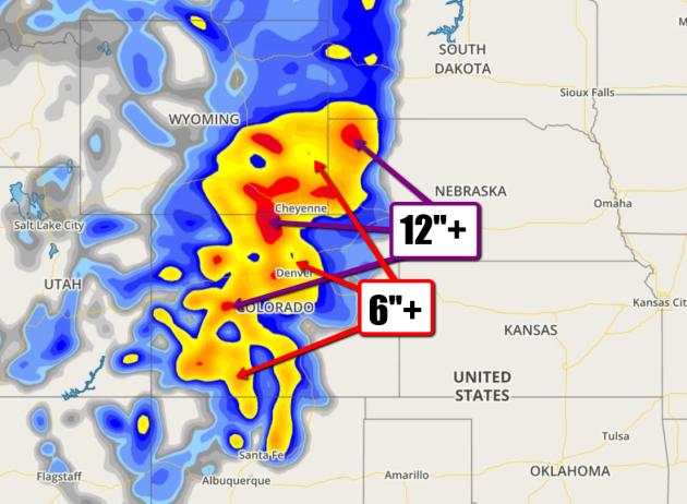
Snowfall Potential
Heavy snowfall will not be limited to just parts of Colorado. Note that fairly significant amounts look to stretch from northern portions of New Mexico to Wyoming, Nebraska and South Dakota.
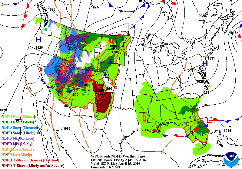
National Weather Outlook
Here's
the storm system responsible for the heavy snow in the Central Rockies
and along the Front Range. Note the slow movement east into the Plains
through the weekend. While heavy snow will be found in locations
mentioned above, heavy rain, flooding and severe storms will be possible
for locations a little farther east.
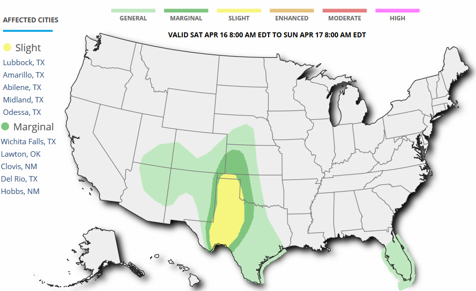
Severe Weather Threat Saturday
According
to NOAA's SPC, severe weather concerns will be possible across western
Texas. Large hail, damaging winds, tornadoes, heavy rain and flooding
may be possible.
...SUMMARY...
   NUMEROUS THUNDERSTORMS...SOME SEVERE...ARE EXPECTED ACROSS PARTS OF
   WEST TEXAS...THE TEXAS PANHANDLE...WESTERN OKLAHOMA AND SOUTHWEST
   KANSAS DURING THE LATE AFTERNOON AND EVENING SATURDAY. LARGE
   HAIL...A FEW TORNADOES AND A FEW DAMAGING WIND GUSTS WILL BE
   POSSIBLE. A MARGINAL SEVERE THREAT MAY DEVELOP FARTHER NORTH ACROSS
   WESTERN KANSAS AND FAR SOUTHEASTERN COLORADO.
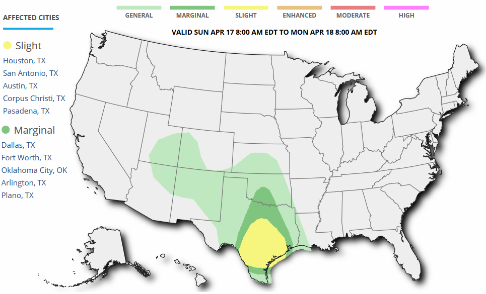
Severe Threat Sunday
Severe weather potential looks to continue yet into Sunday across parts of central and southern Texas.
...SUMMARY...
   SCATTERED STRONG TO SEVERE THUNDERSTORMS WITH LARGE HAIL...WIND
   DAMAGE AND AN ISOLATED TORNADO THREAT WILL BE POSSIBLE IN THE
   SOUTHERN PLAINS ON SUNDAY INTO SUNDAY NIGHT.
_____________________________________________
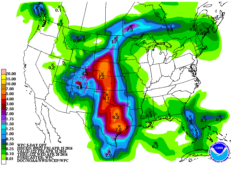
Heavy Rainfall and Potential Across the Central U.S.
As
the slow moving storm system churns east through Central U.S., heavy
rainfall will be possible across much of the Plains and Southern U.S..
Note that some areas over the next 5 days could see as much as 3" to 6"
or more! This could lead to flood concerns, which look to extend through
the weekend.
_______________________________________
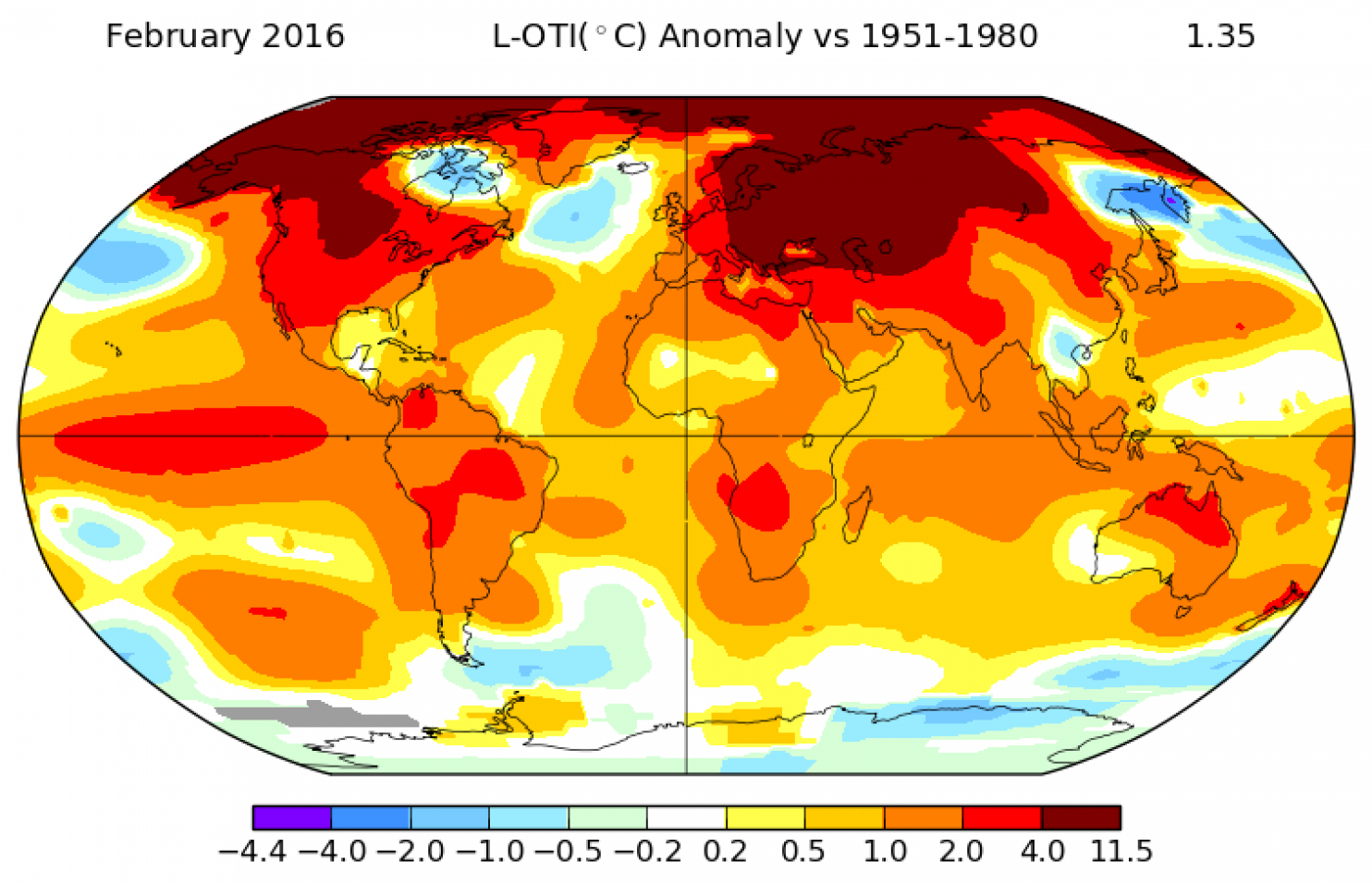
Temperature Anomaly So Far This Month
The
weather pattern has been pretty stagnant so far this month. The first
half of the month features a ridge of high pressure in the Western U.S.
with warmer than average temperatures and a trough in the Eastern U.S.
with temperatures running cooler than average.

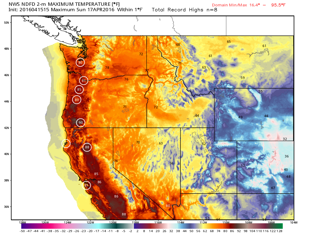
Record Warmth in the Pacific Northwest
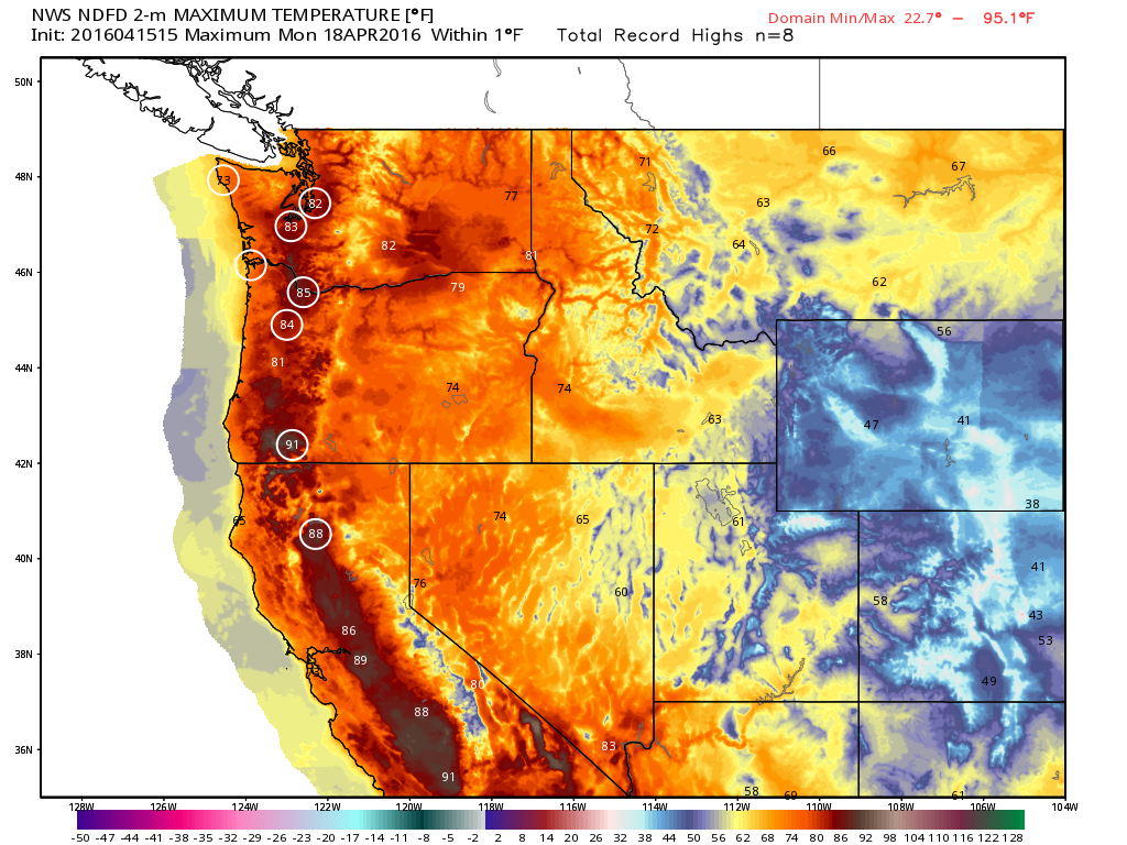
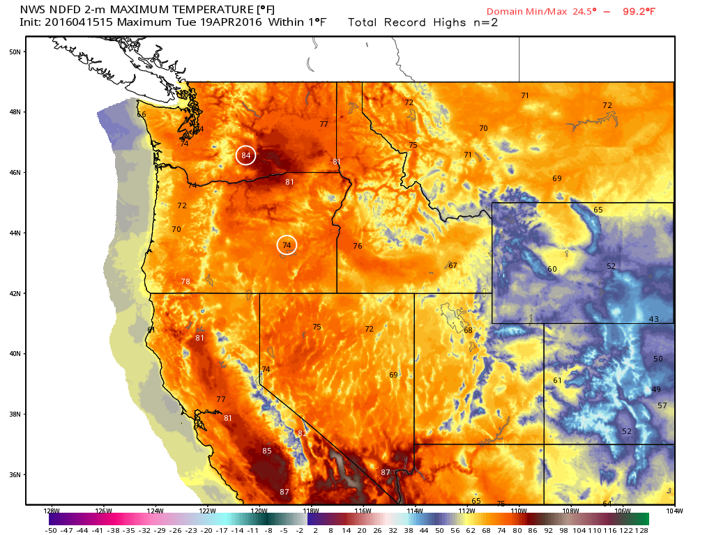
Several days of record warmth will be possible in the Pacific Northwest starting Sunday. The warmest day will be Sunday with highs reaching the 80s from California to Washington. The images below suggest potential record highs for the specific day.
Record Highs Possible Sunday
Record Highs Possible Monday
Record Highs Possible Tuesday
6 to 10 Day Temperature Outlook
According to NOAA's CPC, the extended forecast suggests continued warmth through next week. Much of the nation has a good chance at warmer than average temperatures.
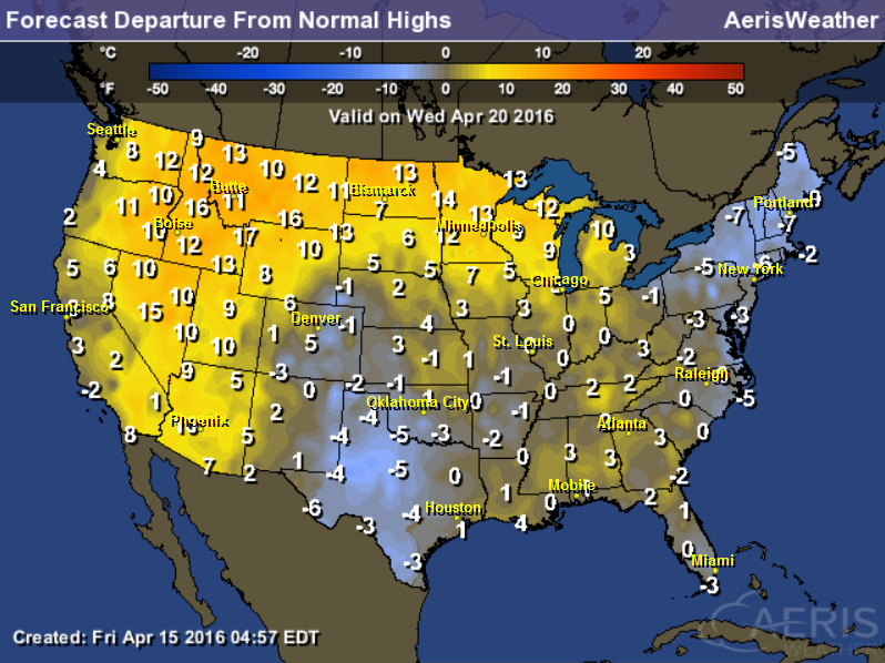
Highs Wednesday, April 20th
Here's a temperature outlook for Thursday, April 21st, which shows mild weather continuing across much of the nation. Note the near 70F highs across the Upper Midwest and Minnesota.
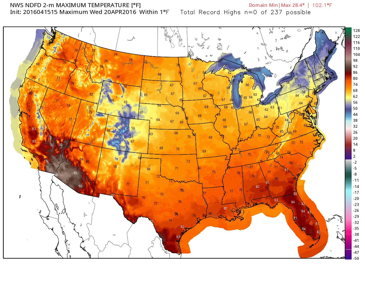
Highs From Average Wednesday, April 20th
High temperatures look to stay well above average across the Western U.S. and across the Upper Midwest by the middle of next week.
___________________________________________
NASA Smacks Down Climate Change Doubters in Facebook Discussion
"In many online forums involving climate change science, the discussions are frequently hijacked by doubters making the same tired, debunked arguments. On Tuesday, NASA was having none of it."
"When doubters began polluting a thread started by Bill Nye “The Science Guy” about his rejected attempt to place a bet about global warming, the Facebook account “NASA Climate Change” decided to pounce."
"When one doubter claimed NASA had confirmed fossil fuels “were actually cooling the planet,” NASA Climate Change fired back: “Do not misrepresent NASA. Fossil fuels are not cooling the planet.”"
See more fromt the Washington Post HERE:
________________________________________
Thanks for Checking in and have a great weekend ahead!
Twitter: TNelsonWX

No comments:
Post a Comment