April Fools!
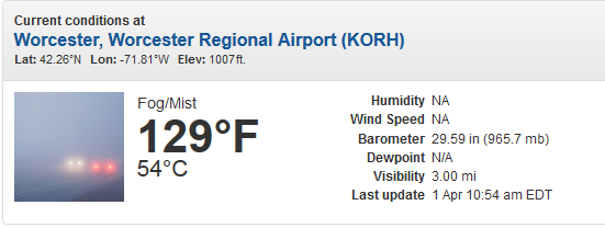 Obviously
the weather sensor out in Worcester, MA wasn't working quite properly
Friday morning, as it showed temperatures in the 100s. Was it just the
sensor playing an April Fools joke on us?
Obviously
the weather sensor out in Worcester, MA wasn't working quite properly
Friday morning, as it showed temperatures in the 100s. Was it just the
sensor playing an April Fools joke on us?
________________________________________________
Windy Friday Across The State
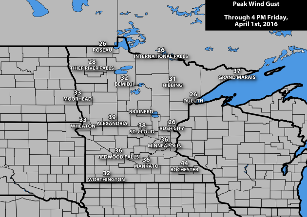 It was a blustery day across the state on Friday, with wind gusts (through 4 PM) topping 40 mph in some spots, including:
Rochester - 44 mph
Park Rapids - 43 mph
Flag Island - 41 mph
Olivia - 40 mph
Another blustery day is expected Saturday across the region - more on how high winds could go in a moment.
________________________________________________
March Was Wet and Warm Across Much Of Minnesota
This March will go down in the record books as a warm and wet one across the state of Minnesota, with numerous NWS climate site locations in the top ten of at least one of the lists.
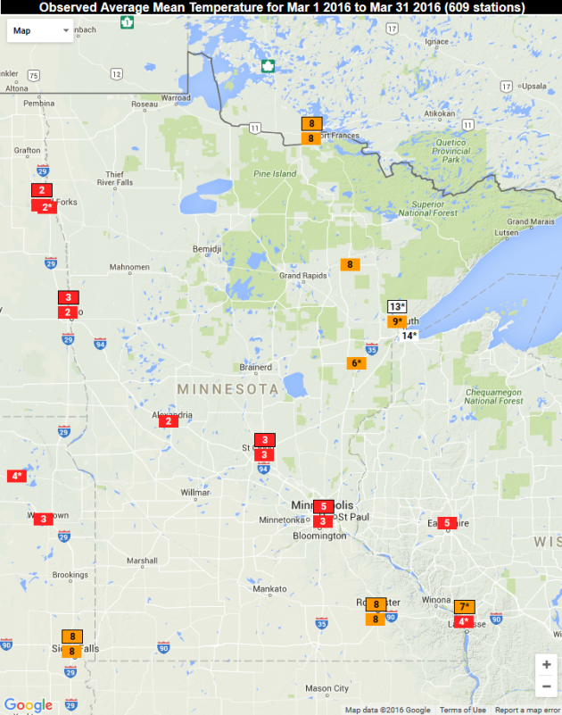 Average Temperature Ranking for the month of March. Graphic: Southeastern Regional Climate CenterStarting
off with looking at average temperature rankings across the state,
esentially every climate location (except Duluth) saw a top ten warmest
March on record. Breaking down the numbers:
Average Temperature Ranking for the month of March. Graphic: Southeastern Regional Climate CenterStarting
off with looking at average temperature rankings across the state,
esentially every climate location (except Duluth) saw a top ten warmest
March on record. Breaking down the numbers:
Twin Cities: 41.3°
St. Cloud: 38.3°
Duluth: 31.6°
International Falls: 29.2°
Rochester: 38.5°
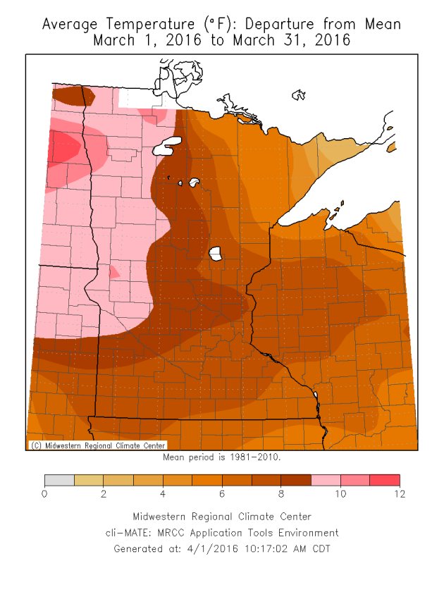 Average Temperature Departure From Average for the month of March. Graphic: Midwestern Regional Climate.The
entire state of Minnesota saw above average temperatures during the
month of March. The warmest areas were in west-central and northwest
Minnesota, which saw average temperatures 9 to 11 degrees above average.
According to climatologist Mark Seeley in his weekly WeatherTalk blog, "March
of 2016 will rank 4th warmest in Minnesota history back to 1895.
Further four of the top five warmest months of March in Minnesota have
occurred since 2000."
Average Temperature Departure From Average for the month of March. Graphic: Midwestern Regional Climate.The
entire state of Minnesota saw above average temperatures during the
month of March. The warmest areas were in west-central and northwest
Minnesota, which saw average temperatures 9 to 11 degrees above average.
According to climatologist Mark Seeley in his weekly WeatherTalk blog, "March
of 2016 will rank 4th warmest in Minnesota history back to 1895.
Further four of the top five warmest months of March in Minnesota have
occurred since 2000."
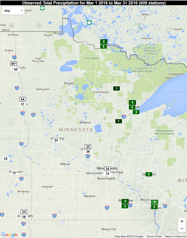 Precipitation Ranking for the month of March. Graphic: Southeastern Regional Climate Center
According to Mark Seeley Minnesota experienced the 4th warmest March since 1895. He writes "four of the top five warmest months of March in Minnesota have occurred since 2000." Ice is coming off area lakes 2-3 weeks ahead of schedule.
No big, beefy storms are brewing, but conditions may be ripe for 70s & severe storms in 2 weeks. After enjoying 40 mph winds and wind chills in the teens this morning (hello February!) temperatures mellow into the 50s Sunday. "Average" temperatures return next week; 40s & 50s likely. Occasional showers, but no weather drama.
 Forecast radar and satellite every three hours between 7 AM Saturday and 7 AM Sunday.
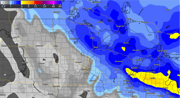 Snow Forecast through Sunday morning.
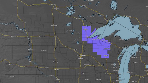

 Severe Threat Saturday.
Thanks for checking in and have a great weekend! Don't forget you can follow me on Twitter (@dkayserwx) or on Facebook (Meteorologist D.J. Kayser)!

________________________________________________
Windy Friday Across The State
Rochester - 44 mph
Park Rapids - 43 mph
Flag Island - 41 mph
Olivia - 40 mph
Another blustery day is expected Saturday across the region - more on how high winds could go in a moment.
________________________________________________
March Was Wet and Warm Across Much Of Minnesota
This March will go down in the record books as a warm and wet one across the state of Minnesota, with numerous NWS climate site locations in the top ten of at least one of the lists.
Twin Cities: 41.3°
St. Cloud: 38.3°
Duluth: 31.6°
International Falls: 29.2°
Rochester: 38.5°
Delving
into the precipitation numbers, three locations across the state saw a
top ten wettest March on record, all of them in eastern parts of the
state.
Twin Cities: 2.26"
St. Cloud: 1.50"
Duluth: 3.96"
International Falls: 2.71"
Rochester: 3.98"
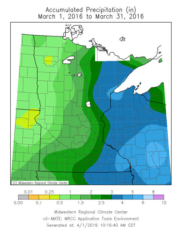 Statewide precipitation for the month of March. Graphic: Midwestern Regional Climate.The
heaviest precipitation across the state was in eastern portions, with
values decreasing as you headed west. According to Mark Seeley, this
March will rank as the 11th wettest on record.
Statewide precipitation for the month of March. Graphic: Midwestern Regional Climate.The
heaviest precipitation across the state was in eastern portions, with
values decreasing as you headed west. According to Mark Seeley, this
March will rank as the 11th wettest on record.
________________________________________________
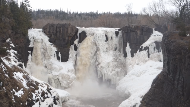
Image via screenshot of Minnesota State Parks and Trails video on Facebook
High Falls At Grand Portage State Park Nears Ice Out
Minnesota State Parks and Trails posted a video on Facebook from Thursday showing ice still on High Falls within Grand Portage State Park, but with a bit of flowing water as well. They are uncertain when they will completely ice out, so stay tuned!
________________________________________________
Twin Cities: 2.26"
St. Cloud: 1.50"
Duluth: 3.96"
International Falls: 2.71"
Rochester: 3.98"
________________________________________________
Image via screenshot of Minnesota State Parks and Trails video on Facebook
Minnesota State Parks and Trails posted a video on Facebook from Thursday showing ice still on High Falls within Grand Portage State Park, but with a bit of flowing water as well. They are uncertain when they will completely ice out, so stay tuned!
________________________________________________
February Relapse Today, Then a Springy Sunday
By Paul Douglas
"Storytelling
is the most powerful way to put ideas into the world today" wrote
Robert McAfee Brown. I'm at the 20th Annual Severe Storms & Doppler
Radar Conference in Des Moines, where as much time is being spent on
storytelling and communication as the science. A perfect forecast is
irrelevant if people don't take appropriate action when skies turn
violent. With social media there's a lot of noise out there - how do
"trusted sources" convince people to get up off the couch and head to
the basement? A work in progress.By Paul Douglas
According to Mark Seeley Minnesota experienced the 4th warmest March since 1895. He writes "four of the top five warmest months of March in Minnesota have occurred since 2000." Ice is coming off area lakes 2-3 weeks ahead of schedule.
No big, beefy storms are brewing, but conditions may be ripe for 70s & severe storms in 2 weeks. After enjoying 40 mph winds and wind chills in the teens this morning (hello February!) temperatures mellow into the 50s Sunday. "Average" temperatures return next week; 40s & 50s likely. Occasional showers, but no weather drama.
_______________________________________________
Extended Forecast for Minneapolis
SATURDAY: Gusty, feels like teens. High: 37. Low: 32. Chance of Precipitation: 10%. Wind: NW 15-35 mph.
SUNDAY: Some sun, milder breeze. High: 57. Low: 33. Chance of Precipitation: 20%. Wind: S 10-15 mph.
MONDAY: Patchy blue sky, turning cooler. High: 44. Low: 37. Chance of Precipitation: 0%. Wind: N 7-12 mph.
TUESDAY: More clouds, few showers likely. High: 47. Low: 35. Chance of Precipitation: 60%. Wind: S 10-20 mph.
WEDNESDAY: Breezy and gray, few sprinkles. High: 45. Low: 33. Chance of Precipitation: 40%. Wind: NW 10-20 mph.
THURSDAY: More clouds than sun, cool. High: 44. Low: 36. Chance of Precipitation: 10%. Wind: NW 10-15 mph.
FRIDAY: Warm front sparks a few showers. High: 53. Low: 41. Chance of Precipitation: 60%. Wind: SE 10-15 mph.
1920: The temperature falls to 8 degrees in Pipestone. The high the day before was 74.
Sunset: 7:43 PM
*Length Of Day: 12 hours, 51 minutes and 53 seconds
*Daylight Gained Since Yesterday: ~3mins & 7secs
*Next Sunrise That Is Before 6:30 AM: April 14th (6:29 am)
*Next Sunset That Is After 8 PM: April 16th (8:01 pm)
Saturday Minnesota Weather Outlook
SUNDAY: Some sun, milder breeze. High: 57. Low: 33. Chance of Precipitation: 20%. Wind: S 10-15 mph.
MONDAY: Patchy blue sky, turning cooler. High: 44. Low: 37. Chance of Precipitation: 0%. Wind: N 7-12 mph.
TUESDAY: More clouds, few showers likely. High: 47. Low: 35. Chance of Precipitation: 60%. Wind: S 10-20 mph.
WEDNESDAY: Breezy and gray, few sprinkles. High: 45. Low: 33. Chance of Precipitation: 40%. Wind: NW 10-20 mph.
THURSDAY: More clouds than sun, cool. High: 44. Low: 36. Chance of Precipitation: 10%. Wind: NW 10-15 mph.
FRIDAY: Warm front sparks a few showers. High: 53. Low: 41. Chance of Precipitation: 60%. Wind: SE 10-15 mph.
_______________________________________________
This Day in Weather History
April 2nd
2001:
Jumbo-sized snowflakes fall in east central Minnesota and west central
Wisconsin. 2.5 to 2.75 inch flakes measured in Maplewood.April 2nd
1920: The temperature falls to 8 degrees in Pipestone. The high the day before was 74.
_______________________________________________
Average Temperatures & Precipitation for Minneapolis
April 2nd
April 2nd
Average High: 51F (Record: 78F set in 1981)
Average Low: 31F (Record: 9F set in 1877)
Average Precipitation: 0.07" (Record: 1.06" set in 2006)
Average Snowfall: 0.2" (Record: 3.4" in 1920)
________________________________________________
Average Low: 31F (Record: 9F set in 1877)
Average Precipitation: 0.07" (Record: 1.06" set in 2006)
Average Snowfall: 0.2" (Record: 3.4" in 1920)
________________________________________________
Sunrise/Sunset Times for Minneapolis
April 2nd
Sunrise: 6:51 AMApril 2nd
Sunset: 7:43 PM
*Length Of Day: 12 hours, 51 minutes and 53 seconds
*Daylight Gained Since Yesterday: ~3mins & 7secs
*Next Sunrise That Is Before 6:30 AM: April 14th (6:29 am)
*Next Sunset That Is After 8 PM: April 16th (8:01 pm)
________________________________________________
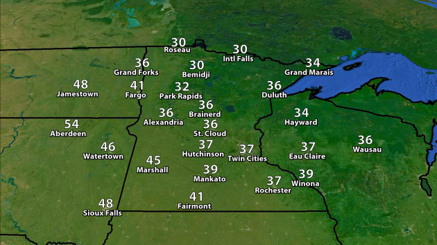
Highs
will remain cool across the state today, with some parts of northern
Minnesota barely making it into the 30s for highs. It'll also be a windy
day once again, with gusts in the 30 to 40 mph range at times from the
northwest, making it feel like the teens and 20s during the afternoon
here in the Twin Cities.
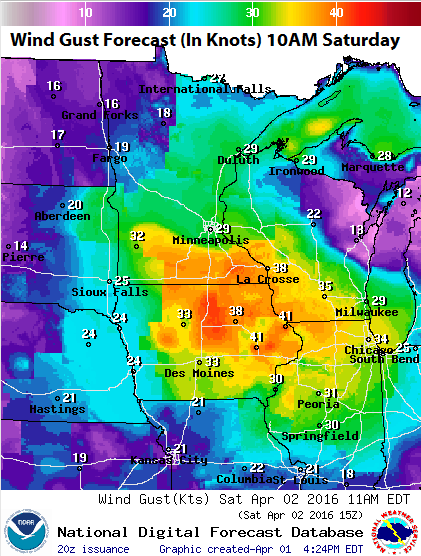
Wind
speeds will be up in the 35-45 mph range by the mid-morning hours,
slowly decreasing as we head toward the late afternoon hours. The
highest wind speeds during the day Saturday across the state will be in
parts of southern Minnesota.
Due
to the strong wind potential Saturday, especially to our south and west, a Wind Advisory has been issued by local NWS offices. Gusts in
these areas could be up to 45 mph during the day Saturday.
While
we will see mainly sunny skies here in the Twin Cities Saturday, the
first of a series of clippers will be moving out from parts of the
Arrowhead during the morning hours. A second clipper will move through
parts of northern Minnesota as we head toward Saturday Night, bringing
the potential of a few more inches of snow.
As
the clippers move through over the next 24-48 hours, parts of northern
Minnesota could see a total of 3-6 inches. The forecast above only accounts for snow through Sunday morning.
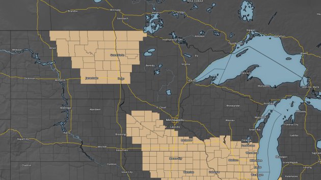
Due
to the amount of snow that could fall by Saturday morning (2-4"), a Winter
Weather Advisory was issued for the Saturday morning hours across
portions of northeast Minnesota and northern Wisconsin, including
Duluth.
_______________________________________________
Severe Weather In The South
Severe
weather has been battering parts of the southern U.S. over the past
couple days, with numerous reports of tornadoes, hail, wind and
flooding. This picture was from early Friday morning in Warner Robins,
GA (courtesy @WarnerRobinsPD on Twitter) which was under a tornado
warning at the time of the damage. An 83 mph wind gust was reported at
the Warner Robins AFB as the storm rolled through.
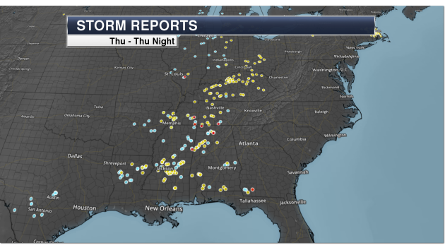
Here
was a look at the storm reports stepping back a day to Thursday and
Thursday Night. According to the SPC, there were four tornado reports,
154 wind reports and 71 hail reports.
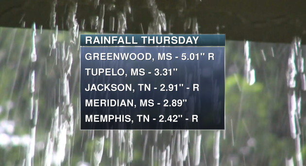
Heavy
rain has also been falling with these storms. Greenwood, MS along with
Jackson and Memphis, TN all saw rain records Thursday, with at least two
inches of rain falling.
________________________________________________
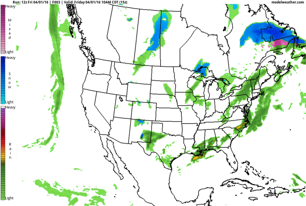
National Outlook
The
potential of severe weather will move south across portions of the Florida
peninsula on Saturday as the cold front
continues to drive south and east. Parts of the Great Lakes and the
Northeast will continue to see clipper after clipper bring the chance of
some snow to the regions. 3-6" of snow are possible for areas like Buffalo and Rochester in New York state Saturday afternoon and evening. New York City and Philadelphia are under a High Wind Watch Saturday Night into Sunday Morning due to winds up to 60 mph possible. Meanwhile, back out west a batch of moisture off the Pacific looks to
move into parts of the Northwest as we head into early Monday.
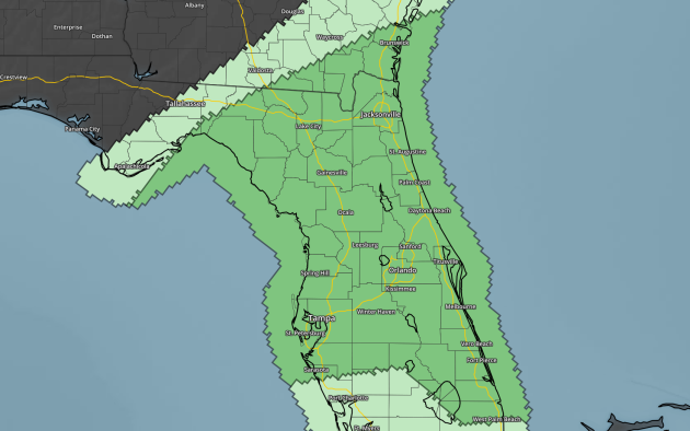
The
Storm Prediction Center has issued a Marginal Risk of severe weather
Saturday across portions of Georgia and Florida. Hail, strong winds and
maybe a tornado will be the main threats along with heavy rain.
_______________________________________________
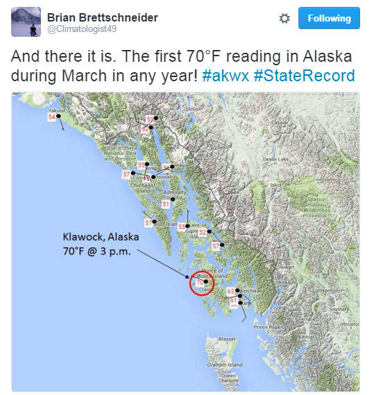
70 In March... In Alaska?
No city in Alaska has ever hit 70 degrees in the month of March - until Thursday. Read more from the Alaska Dispatch News: "The
temperature measured at Klawock Airport in Southeast Alaska hit 71
degrees, which University of Alaska Fairbanks climate researcher Brian
Brettschneider said is a record high for the state for the month of
March, in any year on record. Before
2016, Alaska temperatures in March hadn't hit the 70-degree mark for
any years on record. Brettschneider said the previous March record-high
temperature in Alaska was 69 degrees, recorded in Ketchikan on March 28,
1915."
_______________________________________________
- D.J. Kayser
No comments:
Post a Comment