71 F. average high on May 21.
74 F. high on May 21, 2015.
May 22, 2011: A strong EF-1 tornado with wind speeds up to 110 mph strikes north Minneapolis, causing extensive tree and structural damage. The tornado touched down in St. Louis Park and moved through north Minneapolis, lasting 14.25 miles before dissipating in Blaine after causing minor damage to the Anoka County Airport. The tornado reached a peak width of 1/2 mile.
May 22, 2001: Record cold high temperatures are set in over 30 cities in Minnesota, including a chilly 47 in the Twin Cities and 39 at Grand Rapids and Pine River. Half of an inch of snow falls at International Falls.
May 22, 1925: Temperatures take a nosedive from 100 to 32 degrees in 36 hours at New Ulm and Tracy.
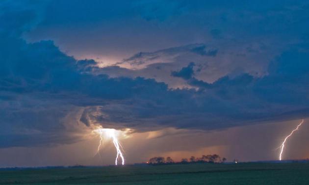
Severe Clear, But There's No Place for Complacency
What happened to a "robust severe weather season"? Coming out of the last jumbo El Nino in 1998 Minnesota was wracked with tornadoes and large hail. So far this year: 1 severe storm warning for the south metro.
Data suggests this is the second latest year on record with so few severe thunderstorm warnings in the Twin Cities. Not as quiet as 1997, when the first warnings weren't issued until June, but amazing nonetheless.
Careful not to let your guard down. Dr. Kenny Blumenfeld at the State Climatology Office tells me that in spite of a record-late start, 1997 brought an exceptionally-destructive severe outbreak in July; a dozen tornadoes, some significant, along with record rains. "It stayed pretty active for the rest of the summer" Blumenfeld added.
We all know it can change in the blink of an eye.
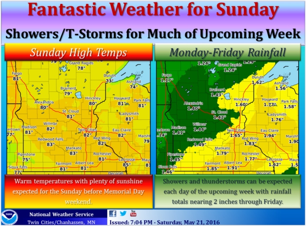
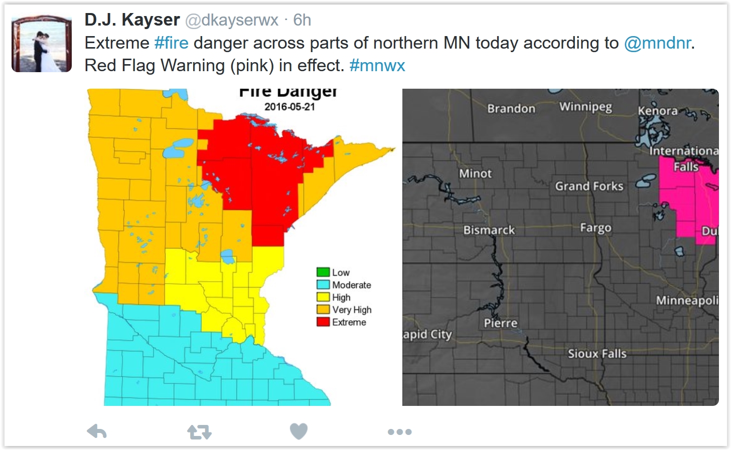
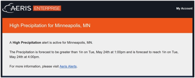
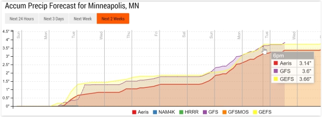
A lake-worth Sunday treats us to 80F with smoky sun (Canadian wildfires). Thundershowers arrive Monday, potentially heavy rain Wednesday with T-storms popping up for the holiday weekend. Next weekend looks warm/sticky with rumbles of thunder and highs near 80F. Could be worse.
No Place for Complacency. Here's an excerpt of an e-mail Dr. Kenny Blumenfeld sent me late last week, outlining a supernaturally quiet severe weather season, to date, in and around the Twin Cities - and the potential peril of letting our guard down: "The other night I stumbled upon something that may interest you: the MPX CWA has had one severe thunderstorm warning so far this year, which makes it the second latest we’ve been with so few severe thunderstorm warnings (note: not tornado warnings) since 1986. The first one in 1997 wasn't issued until June! Lest we make too much of this, it’s worth noting that despite its lateness, 1997 produced an exceptionally destructive severe weather and rainfall event on July from central MN into the Metro on July 1. That system produced over a dozen tornadoes, many of which were significant, and extreme straight-line winds, along with 100-year/1-hour rainfalls. It stayed pretty active for the rest of the summer, and we had a killer tornado near Onamia on Sep 18th. But, perhaps this is an interesting stat nonetheless..."
- Dr. Kenny Blumenfeld, Senior Climatologist, State Climatology Office, Minnesota DNR.
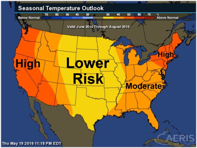
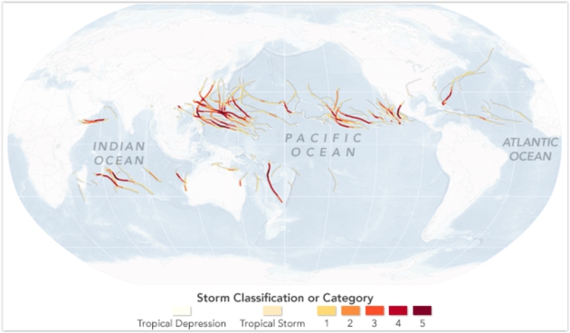
Map credit: Probability of warmer than average temperatures, June thru August, courtesy of NOAA Climate Prediction Center and AerisWeather.
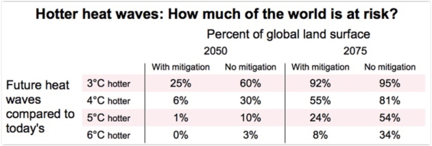
Graphic credit: "For large portions of the world's land surface, future heat waves with a 1-in-20 chance of occurring in any given year are projected to become more extreme than heat waves with the same chance of occurring today. Stringent efforts to mitigate human-produced carbon emissions would reduce the amount of land area at risk for these intense heat waves—defined as three days of exceptionally hot temperature."
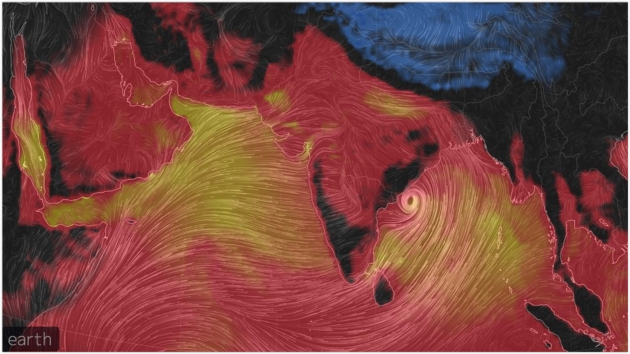
Map credit: "Misery Index showing temperatures plus dewpoint levels across India on May 19, 2016." Image: Earth Simulator.
* The BBC has more details on record heat in India here.

Pray for Shade: Heat Wave Sets a Record in India. The New York Times provides more perspective: "People weren’t frying eggs on the sidewalks in Phalodi during India’s
hottest day ever — in fact, it was so hot that many did not venture out
at all. Heat is a familiar part of life in Phalodi, in the deserts of
Rajasthan, so residents were following a familiar drill even before
temperatures soared to 123.8 degrees Fahrenheit on Thursday: When the
heat comes, stay indoors, chug buttermilk and, if you must go out, cover
your head and pray for shade. It is a drill that may prove ever more
necessary if temperatures continue to rise..."

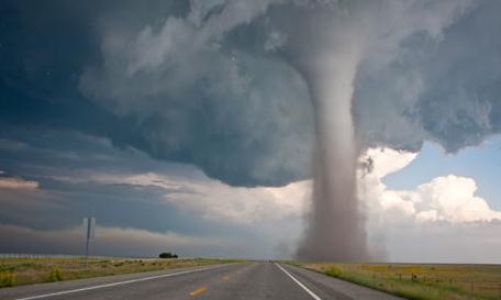
Remarkable Tornado Footage. Here's a link and story excerpt from For The Win: "In this terrifying footage captured on May 9th, a tornado rips through the towns of Katie and Wynnewood, Oklahoma..."

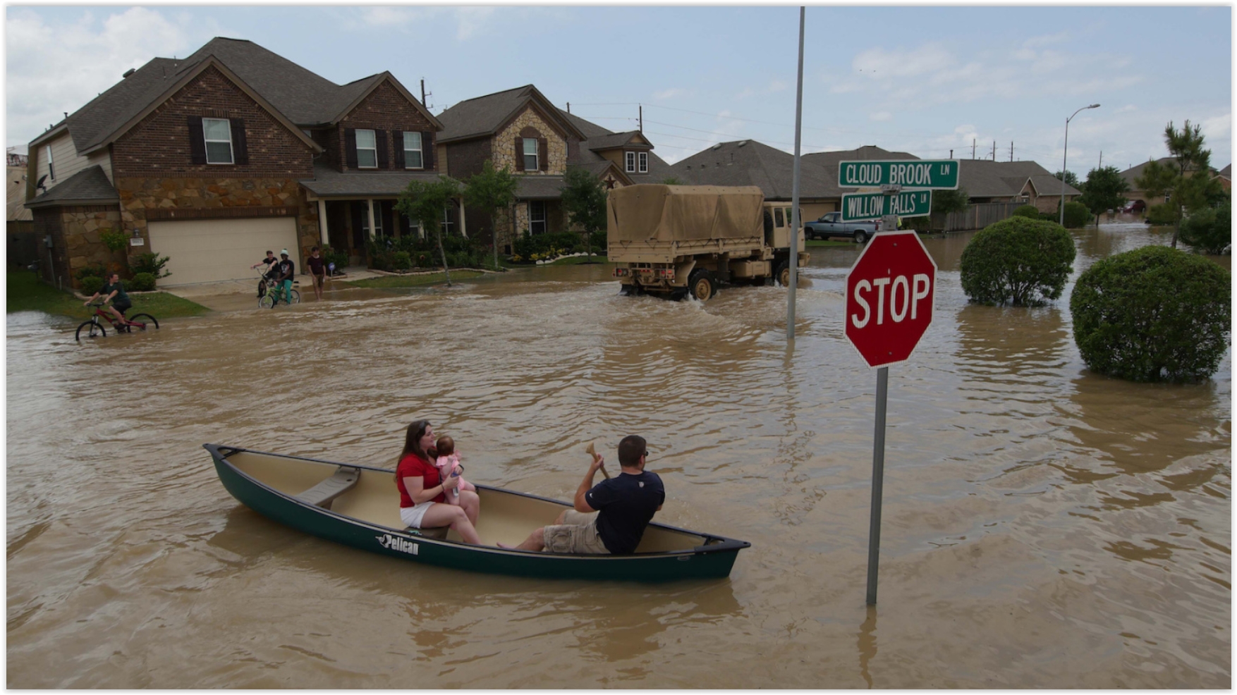
5 Surprising Ways Natural Disasters Can Hurt Your Finances. The old Boy Scout motto applies: "Be Prepared". Here's an excerpt of a story with some very good advice from U.S. News: "...If you've lost – or can't easily access – vital paperwork, from social security cards and birth certificates to insurance information, you could experience delays in getting your insurance claims processed, government financial assistance and more. That's why it's important to know where your documents are. If you live in an area prone to natural disasters, consider making copies of your most important documents and storing them electronically, says Chloe Demrovsky, executive director at Disaster Recovery Institute International, a nonprofit specializing in business continuity and health and disaster emergency management..."
File photo credit: Reuters, TPX Images.
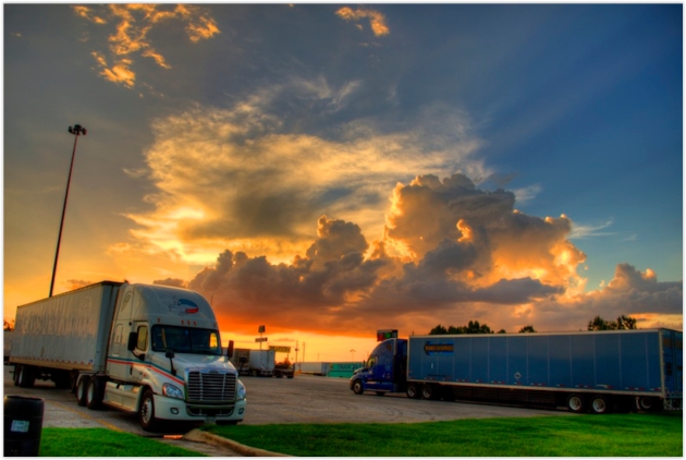
Photo credit: Overdrive Magazine.
“The
rule is pretty simple: Inside beats outside. Below ground beats above
ground. First floor beats upper floors. If you can get out of your
vehicle, and into a building, preferably below ground, that’s what you
should do,” said Keith Stammer, the longtime emergency management
director of Joplin, Mo., and no stranger to the devastation that can be
wrought by a massive tornado.
If no shelter is available, every emergency official interviewed said being outside of the vehicle in a low-lying area was still safer than staying in the cab of the truck, although they cautioned to make sure that the low-lying area wasn’t an immediate risk for flash flooding.
- See more at: http://www.landlinemag.com/Story.aspx?StoryID=31201#.Vz-awr4fgkc

- A shift away from commodity coverage. "The digital news marketplace nudges us away from covering incremental developments — readers can find those anywhere in a seemingly endless online landscape. Instead, it favors hard-hitting 'only-in-The New York Times' coverage: authoritative journalism and information readers can use to navigate their lives..."

Weathering the Storm of Change. These are especially unsettling, disruptive times due to a convergence of factors. I had a chance to talk about my personal experiences with 4 weather-technology companies and offered up a little advice to the Alexandria Area Economic Development Commission's Small Business Appreciation Lunch at the Alexandria Technical and Community College last Tuesday. Here's an excerpt from the Alexandria Echo Press: "During his presentation, Douglas shared tips for businesses and entrepreneurs:
• Ask yourself: Is your business storm proof? Try to anticipate change and plan for it.
• Timing is everything. Being too early is just as bad as being too late.
• Embrace mistakes. Learn from them. One of his favorite quotes: "Be wrong as fast as you can."
• Don't be afraid to explore new ideas, daydream and re-imagine..."

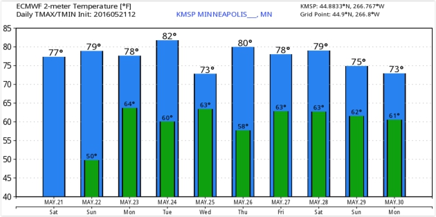
TODAY: Warm sun, breezy. Winds: S 10-20. High: 82
SUNDAY NIGHT: Partly cloudy and mild. Low: 63
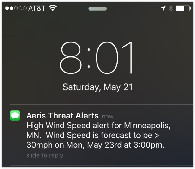
MONDAY: Humid, few showers, T-shower possible. Winds: S 10-20. High: 78
TUESDAY: Some sticky sun, isolated thunderstorm. Winds: S 7-12. Wake-up: 62. High: 82
WEDNESDAY: Heavier rain, few strong T-storms? Winds: E 10-15. Wake-up: 64. High: 72
THURSDAY: Drying out a little, peeks of murky sun. Winds: NW 7-12. Wake-up: 60. High: 76
FRIDAY: Sunny start, strong T-storms possible late. Winds: SE 10-15. Wake-up: 62. High: 79
SATURDAY: Unsettled, nagging thunder risk. Wake-up: 63. Winds: SW 8-13. High: near 80
Climate Stories...


Group of House Republicans Assail Climate Fraud Investigations. No company has a First Ammendment right to deceive or defraud their investors - that is what is under investigation. InsideClimate News has the details; here's an excerpt: "...The
irony of this letter is breathtaking, as its signatories appear to be
part of a multi-pronged media campaign funded by the fossil fuel
industry aimed at suppressing the free exchange of ideas among
scientists, academics, and responsible law enforcement. New York will
continue to work with and collaborate with its colleagues across the
country, and those with expertise in this area, to protect its citizens
from fraud," said Soufer. Ever since Smith gained control of the committee in 2013, its most conservative faction has aggressively questioned climate science and funding, including charging the scientists at the National Oceanic and Atmospheric Administration of misrepresenting climate data..."
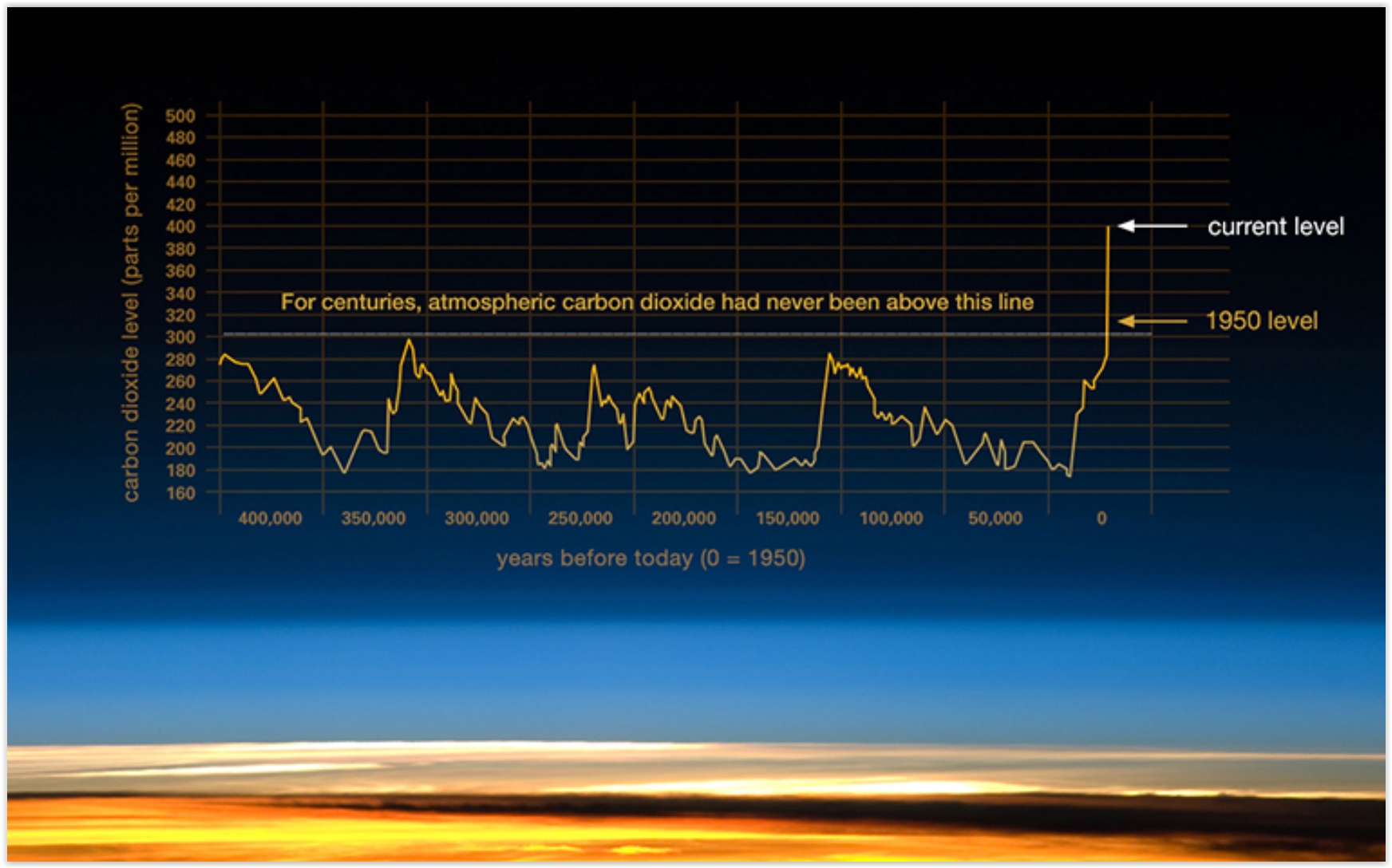
Carbon Dioxide's 400 ppm Milestone Shows Humans are Rewriting the Planet's History. Here's an excerpt of a post at The Guardian: "...So when was the last time the planet had CO2 levels like this, and what sort of a world was it? Dr David Etheridge, a principal research scientist at Australia’s CSIRO, told me: “We know [levels of CO2 in the atmosphere] from the air extracted directly from ice cores and we can go back to about 800,000 years ago. It is inconceivable that there would be any lasting concentration of CO2 much above about 300 parts per million in that record.” He says analysis of sea sediments can push our estimates of historic CO2 levels back even further – to about two million years. Those records also show today’s levels of CO2 are higher..." (Graphic credit: NASA).
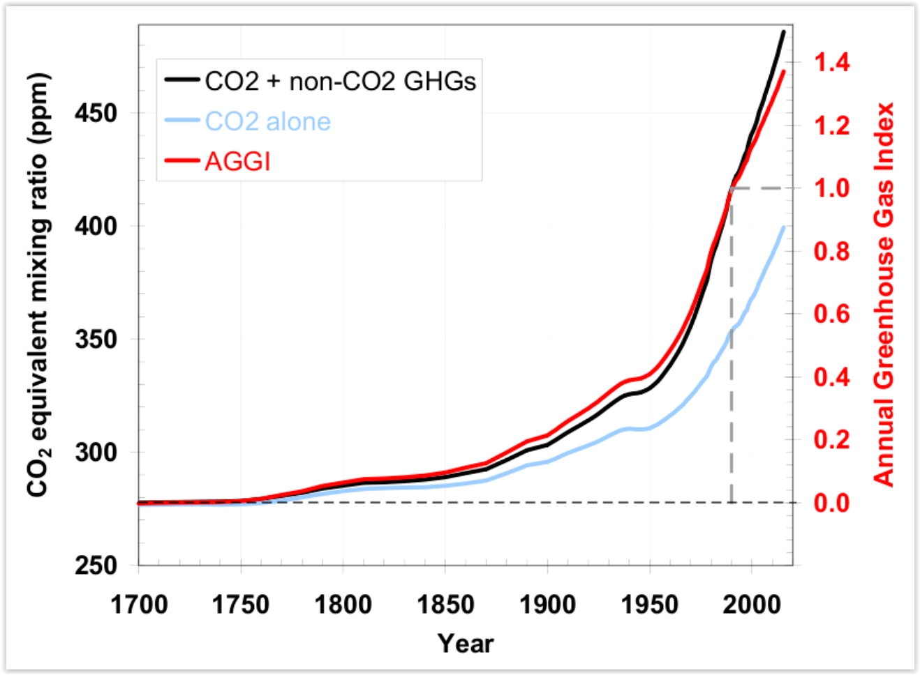
Far From Turning a Corner, Global CO2 Emissions Still Accelerating. InsideClimate News has an update: "The
level of carbon dioxide in the atmosphere is not just rising, it's
accelerating, and another potent greenhouse gas, methane showed a big
spike last year, according to the latest annual greenhouse gas index released by the National Oceanic and Atmospheric Administration.
CO2 emissions totaled between 35 and 40 billion tons in 2015, according
to several agencies. Some of that is absorbed by forests and oceans,
but those natural systems are being overwhelmed by the sheer volume of
new CO2. As a result, the inventory shows, the average global
concentration increased to 399 parts per million in 2015, a record jump
of almost 3 ppm from the year before..."
Graphic credit: "The greenhouse gas inventory shows an accelerated rise in concentrations in recent years." Credit: NOAA.
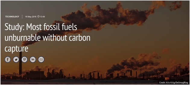
Study: Most Fossil Fuels Unburnable Without Carbon Capture. Here's the intro to a story at Carbon Brief: "The
majority of fossil fuel reserves are unburnable if the world is to
avoid dangerous climate change, but carbon capture and storage (CCS)
could “unlock” greater use, a new study concludes. The white paper, from Imperial’s Sustainable Gas Institute,
challenges previous findings that CCS makes little difference to the
quantity of fossil fuels that can be burned, within a 2C carbon budget..."
Photo credit: Kris Krug, DeSmogBlog.
Researchers Help Miami Community Plan For Sea Rise, Climate Change. Here's an excerpt from The Miami Herald: "...In a recent op-ed, Merleaux wrote about the project and explained environmental problems facing Miami, South Florida and the world. According to her findings, “scientists predict between 4-6 feet of sea level rise here by the end of the century. These changes will require people to make some very difficult decisions as they prioritize how to invest and what to protect.” Although she has only lived in Miami for six years, the mother of two said she is concerned for her family, neighborhood and the global community..."
No comments:
Post a Comment