52 F. high in the Twin Cities Saturday.
69 F. average high on May 14.
57 F. high temperature on May 14, 2015.
May 15, 1998:
Damaging tornadoes impact Minnesota. One tornado hits a flea market in
Albany, killing one person and injuring 30 others. 102 homes are
severely damaged in the northern Twin Cities due to another tornado.
May 15, 1969: Torrential rain occurs in Synnes Township, dumping 8 inches of rain in three hours.
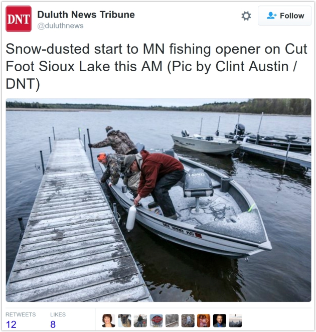
Saved By a Breeze - May Mellows This WeekWell
that was fun, as refreshingly unexpected as a cold slap across the
face. Yesterday may have been the coldest Minnesota Fishing Opener since
2004.
Freezing temperatures were reported across central and western counties
- a coating of snow delighted anglers over the Minnesota Arrowhead.
Once
again we're waking up to frosty temperatures, mainly north of the MSP
metro. The same gusty wind that carved out whitecaps on area lakes
yesterday kept the low layers of the atmosphere stirred up. That,
coupled with the urban heat island, prevented widespread frost damage in
the immediate Twin Cites.
The last few days were a vivid reminder
that the march into summer rarely goes in a straight line, but lukewarm
days are coming. A stray instability shower sprout
s Monday
afternoon; otherwise dry weather is the rule this week with highs in
the 60s - 70s by late week. Mother Nature may restore your faith in May
next weekend with mid-70s under a sunny, lake-worthy sky.
A sticky warm front may shove heavy T-storms into tow
n in 8 days; enjoy the quiet spell and a well-deserved warm front.
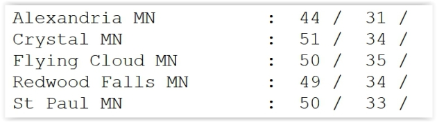
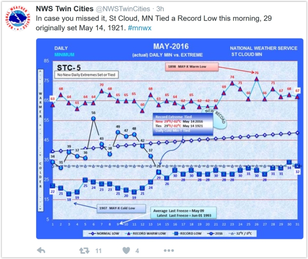
Saturday Morning Lows. St. Cloud tied a record Saturday morning at 29F, 34F at MSP International and Crystal but 33F St. Paul and 31F in Alexandria.
St. Cloud Record. Saturday's wake-up air temperature of 29F at St. Cloud tied the record set in 1921.
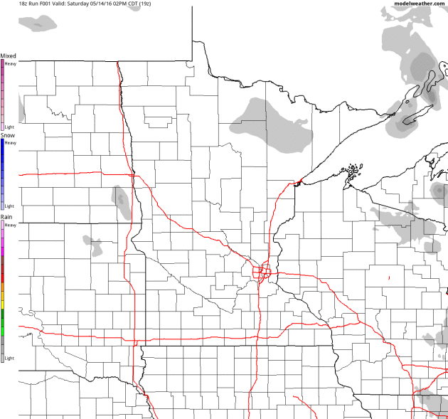
Late Showers Far Northern Minnesota.
A wrinkle of cold air rotating around a broad trough of low pressure
ignites a few instability showers over far northern counties by late
afternoon or evening - the same feature may spark a couple of showers in
the Twin Cities by Monday afternoon. 2-meter precipitation type: NOAA
and AerisWeather.
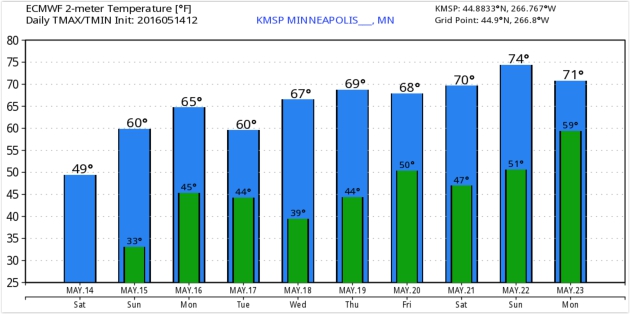
Suitable For Framing.
After a cool, wet week and October-like Fishing Opener temperatures
recover nicely this week; 70 degrees by late week as chilly air finally
retreats into Canada. Good riddance. Source: WeatherBell.
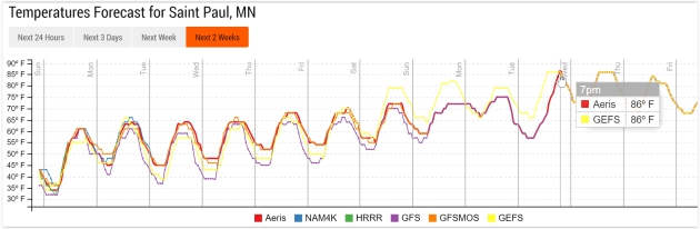
80s Early Next Week?
I wouldn't take it to the bank, not yet, but the trends are
encouraging. GFS guidance hints at low to mid 80s by early next week
(with a good chance of heavy T-storms). Source: Aeris Enterprise.
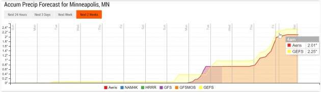
Heaviest Rains Pass South of Minnesota Next 10 Days.
GFS model guidance (accumulated rainfall) prints out excessive amounts
of rain from the Central and Southern Plains into the Mid South,
compounding the flooding woes in Texas and Louisiana.
Dry Week - Storm Potential Increases Again Next Week.
Any rainfall amounts from Monday PM showers should be light - dry
weather the rule into Sunday. But models suggest a heightened risk of
showers and T-storms, some potentially heavy, by next week.
Welcome Rains Arrive. Here's an excerpt of Mark Seeley's latest post at
Minnesota WeatherTalk: "
After
starting the month with 8 consecutive dry days, interspersed with some
record-setting high daily temperatures (90s F in many areas), and low
relative humidity (7-15 percent range) some widespread welcome rains
blanketed the state this week. Total amounts were generally less than an
inch in many northern and central counties, but many southern Minnesota
observers reported over 2 inches, including Pipestone, Worthington,
Albert Lea, Fairmont, New Ulm, St James, and Caledonia. A handful of
observers reported over three inches for the week including Windom,
Lakefield, and Sherburn (3.93”)..."
Photo credit: Mike Hall.
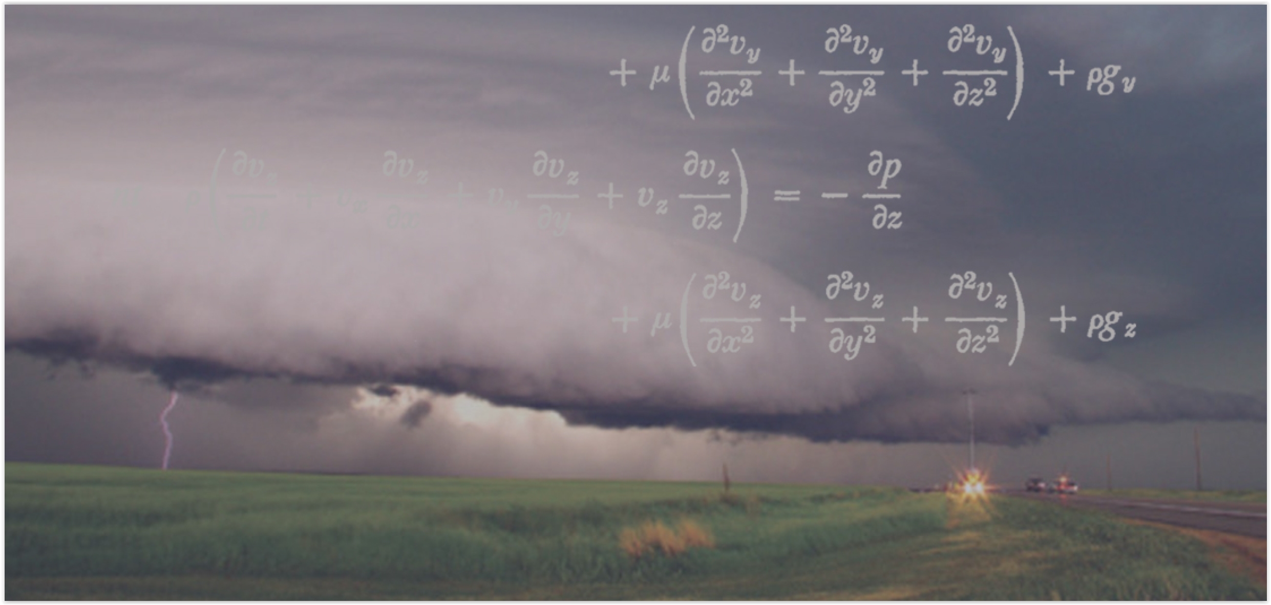
Weather Prediction: It's Math! Lot's and lot's of math - calculus that still gives me night-sweats. Here's an excerpt from
NOAA: "
Dutifully
processing 2.8 quadrillion mathematical calculations per second around
the clock, these computers — each about the size of a school bus — are
the nucleus of weather and climate forecasting in the United States and
the calculations they make are the foundation of NOAA’s life-saving
weather predictions. Every day, the supercomputers collect and organize
billions of earth observations, such as temperature, air pressure,
moisture, wind speed and water levels, which are critical to initialize
all numerical weather prediction models. All these observations are
represented by numbers..."
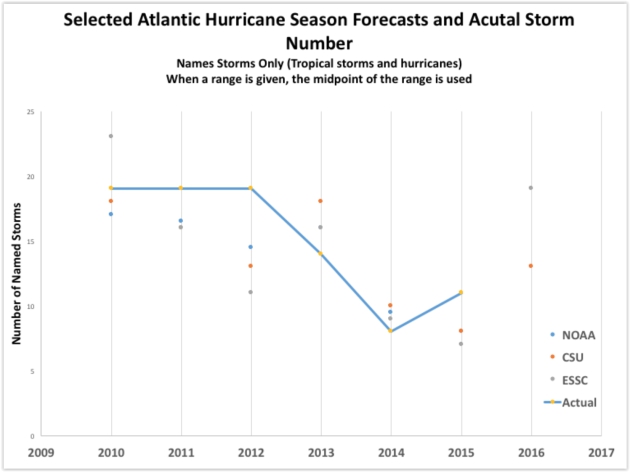
The 2016 Atlantic Hurricane Season. Scientist and writer Greg Laden has an interesting post at
scienceblogs.com; here's the intro: "
This
year’s Atlantic Hurricane season will be stronger, forecasts suggest,
than that of the previous two years, and stronger than the average year.
The Atlantic Hurricane Seasons starts on June 1st. But, there was a
hurricane that happened already, either late in last year’s season or
very early in this year’s season, called Alex. That hurricane had to go
somewhere, and I suppose the keepers of the records had already put
their spreadsheet to bed when Alex came along on January 7th, so that
storm gets counted as part of the season that will nominally start at
the beginning of next month..."
Image credit: "
The
following graphic shows the relationship between the median number of
named storms predicted each year by those three sources and the actual
number of named storms in the Atlantic."
Myths and Facts About Tornadoes. Some very good advice at
Livingston Daily: "...
Another
myth is that you should crawl up under an overpass while a tornado
passes. This is very dangerous. Again, debris is being hurled about —
even under the bridge. Do not try to outrun the tornado in your vehicle.
A tornado has the potential of traveling 60 mph, and they don’t follow a
road like your vehicle. If you see a tornado developing where you are
driving, the best thing to do is pull over and evacuate your vehicle.
Seek shelter in the nearest sturdy building or storm shelter. Do not
hide under your car. The wind could potentially roll your car over. If
there isn’t an available shelter, find the nearest ditch or low-lying
area and crouch low to the ground, covering your head with your arms.
Don’t forget, sturdy buildings are all around you. Fast-food
restaurants, banks, and churches may offer shelter and a safe place to
enter..."
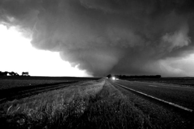
File photo credit: Aaron Shafer.
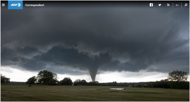
Twister Chasing in Tornado Alley. Josh Edelson at
AFP
takes us along for the frustrations, terror and temporary euphoria of
an ultimately successful tornado chase; here's an excerpt: "...
As
far as taking pictures, it was a challenging situation. I was soooo
excited to finally see one after all these days waiting and all of the
sudden I had to think about things like what lens to use, what aperture
setting, what shutter speed, the ISO, how to compose the shot. At one
point, I was shooting and I realized that for the past five minutes I
had been shooting in manual focus and I thought, “Damn, did I just blow
the whole thing?” (Luckily I didn’t). As I was shooting, I tried to also
just take it all in. It was just monstrous -- there was no end to it,
it just melded into the sky, ominous and otherworldly..."
Photo credit: AFP / Josh Edelson.
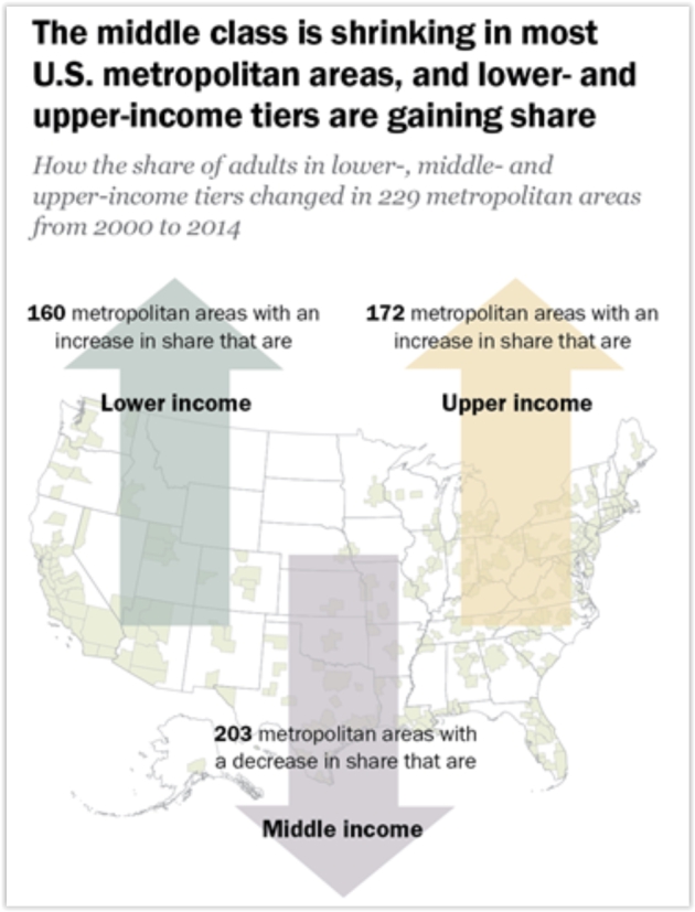
America's Shrinking Middle Class: A Close Look at Changes Within Metropolitan Areas. Why are we so angry? New findings from Pew Research Center offers strong clues: "The
American middle class is losing ground in metropolitan areas across the
country, affecting communities from Boston to Seattle and from Dallas
to Milwaukee. From 2000 to 2014 the share of adults living in
middle-income households fell in 203 of the 229 U.S. metropolitan areas
examined in a new Pew Research Center analysis of government data. The
decrease in the middle-class share was often substantial, measuring 6
percentage points or more in 53 metropolitan areas, compared with a
4-point drop nationally..."
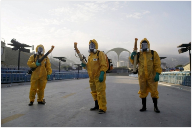
Public Health Professor: Because of Zika, Rio Olympics "Must Not Proceed". No sugar-coating here, as explained at
NPR: "
Amir
Attaran, a professor in the School of Public Health and the School of
Law at the University of Ottawa, isn't afraid to take a bold stand. He
has written a commentary
for the Harvard Public Health Review, published this week, with the
headline, "Why Public Health Concerns for Global Spread of Zika Virus
Means that Rio de Janeiro's 2016 Olympic Games Must Not Proceed." The
World Health Organization is soon expected to release a statement with
guidance on travel to the Olympics..."
Should the 2016 Summer Olympics Still Be Held in Rio?
With additional perspective (that makes me happy to watch the spectacle
on television, but wondering how I would feel if I had a son or
daughter participating in the games) here's an excerpt of an Op-Ed at
The Washington Post: "...
Still,
there are two reasons why I suspect that Attaran is not overreacting.
The first is that a big global gathering like the Olympics seems tailor
made to spread the disease. Normally when an epidemic breaks out, the
concern is that people will travel from the infected area to other
places to spread the disease, and whether other governments are
overreacting to that migration. Indeed, that’s the cause of the myriad
epidemiological freakouts that have occurred this century: SARS, H1N1,
Ebola, etc. This is a different question. This is all about whether it’s
a good idea to have a major global event in a city
that is in the middle of this kind of outbreak. This strikes me as a
different kind of debate. Is it really such a hot idea to have a
significant global gathering in the middle of a hot zone?..."
Photo credit: "
Municipal workers wait before spraying insecticide at Sambodrome in Rio de Janeiro on Jan. 26." (REUTERS/Pilar Olivares).
Scientists Can Now Make Lithium-Ion Batteries Last a Lifetime. Computerworld has the story; here's the intro: "Who
says playing around is a waste of time? Researchers at the University
of California at Irvine (UCI) said that's exactly what they were doing
when they discovered how to increase the tensile strength of nanowires
that could be used to make lithium-ion batteries last virtually forever.
Researchers have pursued using nanowires in batteries for years because
the filaments, thousands of times thinner than a human hair, are highly
conductive and have a large surface area for the storage and transfer
of electrons..."
Photo credit: "
University
of California doctoral student Mya Le Thai holds a nanowire device that
has the potential to enable hundreds of thousands of recharges in a
lithium-ion battery." Credit:
Steve Zylius/UCI
Try Not To Jiggle While Watching These Amazing Bladeless Wind Turbines. Is this the future of wind power? Here's an excerpt from upworthy.com: "...It's
called Bladeless, and it's a wind turbine with — you guessed it — no
blades.The bladeless turbines are massive poles jutting out of the
ground. Because they're thinner than a regular wind turbine and have no
blades, more of them can fit into a space, meaning more electricity can
be generated while taking up less real estate. So how does the bladeless
turbine generate power?..."
Image credit: "
Jiggle jiggle jiggle." GIF via
Vortex Bladeless/YouTube.
This Scientist Has Created Speakers that Spew Scents, Not Sounds. What about knitted socks? Here's another excerpt of a wonderfully head-scratching article at Atlas Obscura: "David
Edwards is obsessed with olfaction. The Harvard University professor
has spent the last five years building a library of digital smells. The
goal? To figure out a way to transmit those aromas through
technology—carrying and communicating scent memories through the air. Now, he has stored a selection of these scents on a “scent speaker” called Cyrano. The
device emits olfactory notes, which you can arrange into playlists on a
smartphone app. With a few bursts, a home stereo system in a New York
City apartment can evoke the scents of a Hawaiian vacation, or a
Christmas market in Germany..."
Photo credit: "Cyrano is David Edwards new invention to communicate through scent." (Photo: © Wayne E. Chinnock/Vapor Communications).
Find Out If Your Name Was Ahead of Its Time. How popular was your name when you were born? A calculator at TIME brings out the inner-narcissist in all of us: "...To find out how popular your name was
when you were born—and how it has fared since then—enter your gender,
birth year and first name into this interactive. We’ll tell you which of
eight categories your name fits into based on your birth year, like “trendsetter,” “Mr. or Ms. Popular,” or even a “snowflake”—a name that was never common..."
TODAY: Sunny and milder after a frosty start in some outlying suburbs. Winds: NW 10-15. High: 61
SUNDAY NIGHT: Clear and cool. Low: 47
MONDAY: Clouds increase, PM shower. Winds: NW 7-12. High: 63
TUESDAY: Bright sun returns, light winds. Winds: NE 7-12. Wake-up: 44. High: 64
WEDNESDAY: Sunny and spectacular. Winds: S 5-10. Wake-up: 49. High: 69
THURSDAY: Blue sky, mild breeze returns. Winds: S 10-20. Wake-up: 51. High: 72
FRIDAY: Partly sunny, lukewarm. Winds: S 8-13. Wake-up: 54. High: 73
SATURDAY: Plenty of sun, cabin-worthy. Winds: SE 8-13. Wake-up: 56. High: 75
Climate Stories...
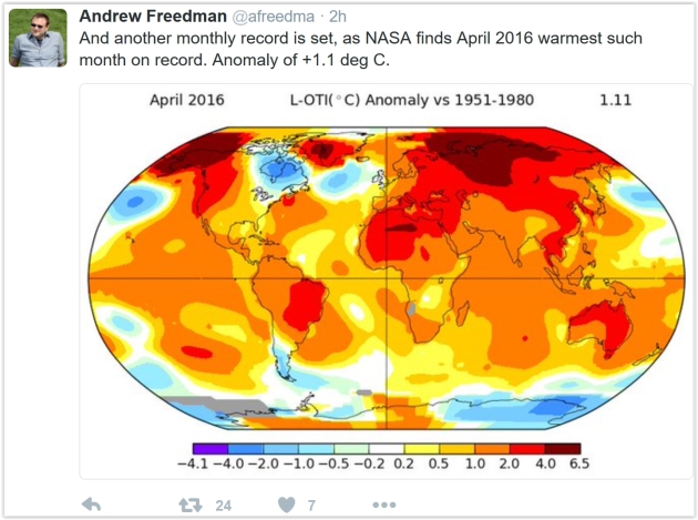
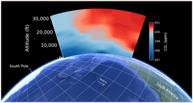
A CO2 Milestone in Earth's History. 400 ppm over Antarctica too? Here's an excerpt from
UCAR: "
Earth’s
atmosphere is crossing a major threshold, as high levels of carbon
dioxide (CO2)—the leading driver of recent climate change—are beginning
to extend even to the globe's most remote region. Scientists flying near
Antarctica this winter captured the moment with airborne CO2 sensors
during a field project to better understand the Southern Ocean's role in
global climate. This illustration shows the atmosphere near Antarctica
in January, just as air masses over the Southern Ocean began to exceed
400 parts per million of CO2. The 400 ppm level is regarded as a
milestone by climate scientists, as the last time concentrations of the
heat-trapping gas reached such a point was millions of years ago, when
temperatures and sea levels were far higher..."
Illustration credit: Eric Morgan, Scripps Institution of Oceanography.
A Brief History of Climate Science. If anyone asks the science dates back to Fourier in the 1820s. Here's an excerpt from climate scientist Ed Hawkins at
The Conversation: "...
What was missing however was an estimate of how much these gases could warm or cool the planet. Svante Arrhenius,
a Swedish chemist, provided the first numerical estimates of “climate
sensitivity” – defined as the temperature change corresponding to a
doubling of carbon dioxide in the atmosphere. He suggested a value
around 4°C in 1896. While the scientists continued to debate the causes
of the ice ages, the Earth was warming. From the 1920s onwards
meteorologists began to realise that the climate of various regions had
changed. Joseph Kincer
suggested in 1933 that temperatures in individual cities had been
rising. At the same time, others had started measuring carbon dioxide in
the atmosphere. But it took an amateur meteorologist to put the puzzle
together..."
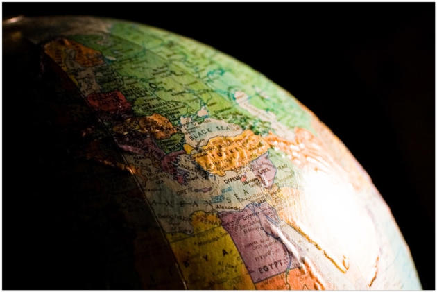
Image credit: "
The future of the globe used to look a lot brighter."
ToastyKen.
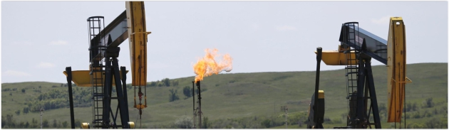
Obama Administration Issues New Rules on Methane Emissions from the Oil and Gas Industry. The rules only apply to new point sources, as explained at
VICE News: "
The
Obama administration issued new rules on Thursday for reducing
climate-warming methane emissions from the oil and natural gas sector,
continuing its string of executive branch actions aimed at addressing
climate change. The regulations cover only new or substantially modified
oil and gas facilities: wells, processors, storage facilities, and
pipelines. The administration says it will be up to the next president
to lead the charge on reining in emissions from existing sources. US
Environmental Protection Agency Administrator Gina McCarthy said the
rules highlight President Barack Obama's commitment to addressing
climate change, and limiting pollutants that compromise public health..."
Photo credit: Charles Rex Arbogast/AP.
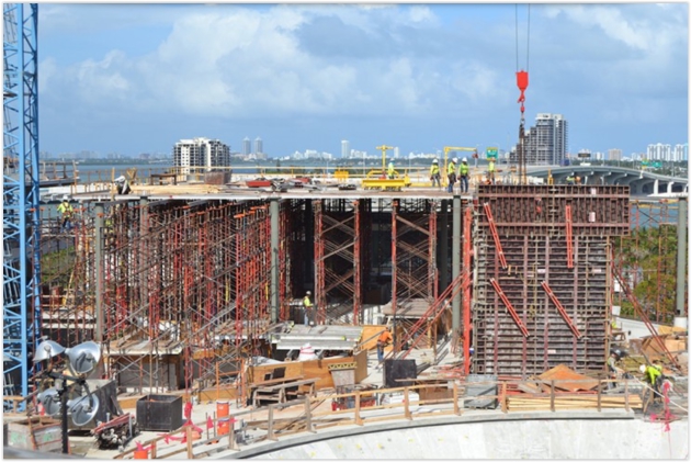
Just Because Sea Level Rise Threatens Miami Doesn't Mean the City Should Give Up. Here's a snippet of an Op-Ed at
Miami New Times: "...
We
know Miami (and, indeed, most of the southern half of Florida) is
particularly vulnerable to climate change. We do not, however, know
exactly when the effects will become untenable. There may be a
scientific consensus on man-influenced climate change and sea-level
rise, but there isn't scientific consensus on a timeline. In any event,
it seems most likely that Miami will continue to be a functioning city
that is home to millions of people for the next few immediate decades
(which translates to a large chunk of human life, if not longer)..."
Photo credit: Carolina del Busto.
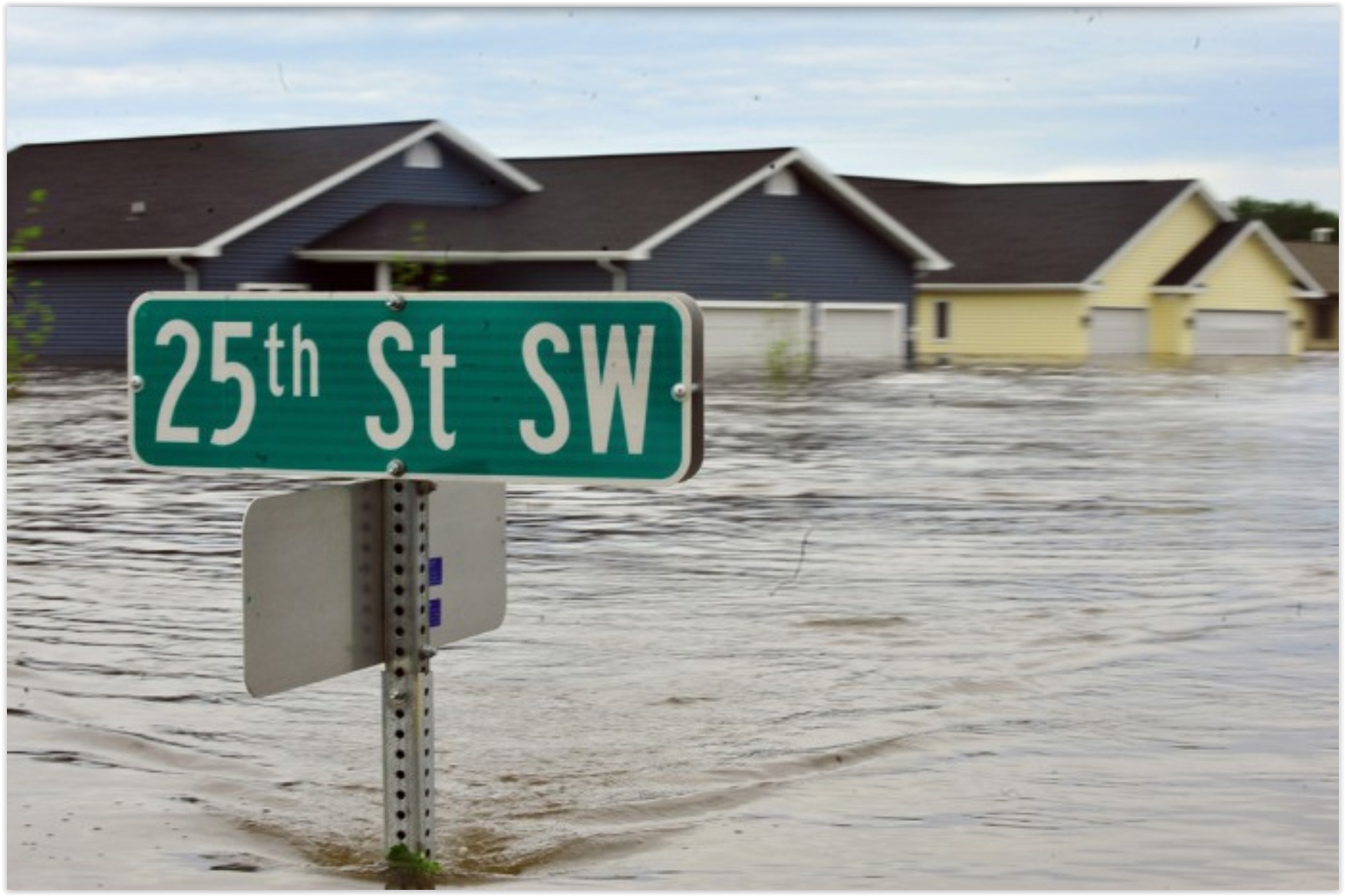 Freddie Mac Economist Warns of Housing Crisis Caused Sea Level Rise
.
New-Times Broward Palm Beach has the story; here's a link and excerpt: "...
In an April "Insight" report
by Freddie Mac, the government-sponsored home loan agency, its chief
economist warned of sea levels and flooding reaching a point where
properties becomes uninsurable and unmarketable, causing homeowners to
begin defaulting on their mortgages. This would instigate another
housing crisis—except this time, it'd be unlikely that housing prices
ever recover. Sean Becketti, Chief Economist, Freddie Mac said in a
statement: “In the housing crisis, a significant share of borrowers
continued to make their mortgage payments even though the values of
their homes were less than the balances of their mortgages. It is less
likely that borrowers will continue to make mortgage payments if their
homes are literally underwater. As a result, lenders, servicers and
mortgage insurers are likely to suffer large losses…"
Photo credit: DVIDSHUB via Wikipedia Commons.
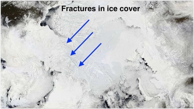
Fractures Seen in Rapidly Melting Sea Ice, and It's Only May. Andrew Freedman has the story at
Mashable; here's a clip: "
Even
accounting for the accelerating pace of Arctic climate change, sea ice
loss in the Far North is running well ahead of schedule. This may signal
a near record or record low sea ice extent to come in September.
Fractures in the ice cover are evident north of Greenland, which Mark
Serreze, the director of the National Snow and Ice Data Center in
Boulder, Colorado, told Mashable are "quite unusual" for this time of
year..."
How Scared or Hopeful Should We Be in a Warming World? The Conversation asks the rhetorical question; here's the intro: "
For
anyone who takes notice of the climate change debate, a mass of
often-contradictory information comes flooding into our lives. Some of
it prompts great alarm. The Great Barrier Reef is suffering severe
bleaching. Wild fires are consuming Alberta. Last year was the warmest
on record, and 15 of the 16 hottest years on record have occurred since
2001. Yet there are also some positive signs that the world is at last
getting serious about the threat. Global investment in renewable energy
last year exceeded investment in fossil energy for the first time. Coal
use in the United States is falling rapidly..."


No comments:
Post a Comment