93 F. high in the Twin Cities Saturday.
78 F. average high on June 11.
67 F. high on June 11, 2015.
June 12, 1917: The ice pack finally breaks up on Lake Superior near Duluth, one of the latest ever 'ice out' dates on record.
More Red Blobs on Doppler: Soggy into Thursday"Live
life for the moment, because everything else is uncertain" wrote Louis
Tomlinson. I don't want to sleepwalk through the rest of my life.
One of these days I'll enjoy a sunset, without feeling the need to photograph it.
One of these days I'll stop checking e-mail in a fishing boat.
One of these days I'll forget to pack my laptop and smartphone before leaving on a trip.
The extended outlook calls for a radical digital-disconnect.
Our
ration of quiet sunshine is history now; the approach of a sloppy
frontal boundary sparks showers and T-storms today. A few storms may
become severe over central and western Minnesota. More pulsating red
blobs on Doppler.
Friday's
swamp-like heat lurks just to our south this week; a wave of showers
and storms bubbling up along the northern edge of this sloppy boundary
results in significant rain
Tuesday and
Wednesday, over an inch possible.
I think I have the timing down: weekday puddles should give way to sunny 80s next weekend; even a shot at 90F a week from today.
Maybe I'll ignore all my technological distractions.
One of these days.
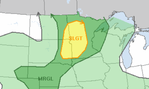
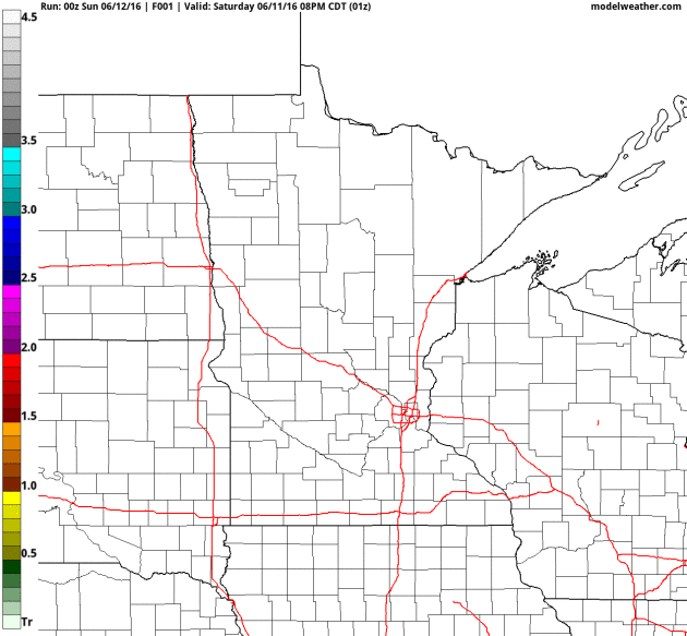
Slight Severe Thunderstorm Risk.
As dew points rise and wind shear aloft increases conditions may be
favorable for a few severe storms later today, especially western and
central Minnesota by late afternoon. According to NOAA SPC the primary
risk is damaging wind gusts.
Isolated 1-2" Rains.
NOAA's 4 km NAM prints out a band of 1-2" across central Minnesota.
That may be the exception, not the rule. Summertime convection is always
fickle: one-inch downpours for one town, while a few miles down the
road the sun is out and people are wondering what all the fuss is about.
60 hour accumulated rainfall: NOAA and AerisWeather.
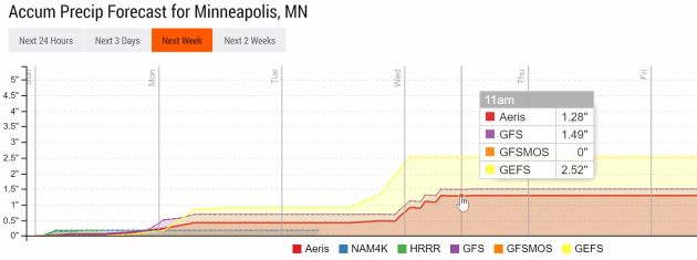
Soggy into Midweek.
One jolt of rain comes today from showers and T-storms. Steadier,
heavier rain is possible late Tuesday into Thursday morning when some
1"+ rainfall amounts are possible as a slow-moving storm tracks across
the state. Source: Aeris Enterprise.
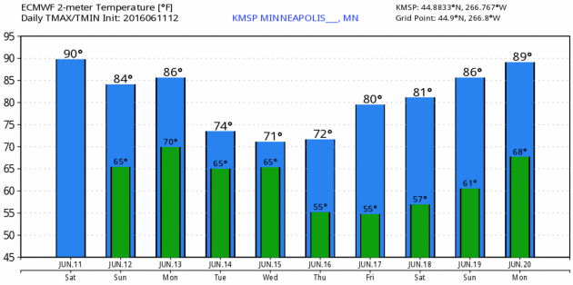
Midweek Cooling - Warming Up Again Next Weekend.
ECMWF guidance (above) shows a break from the heat by midweek, but a
southerly wind kicks in again by the end of the week as 80s return.
Graphic: WeatherBell.
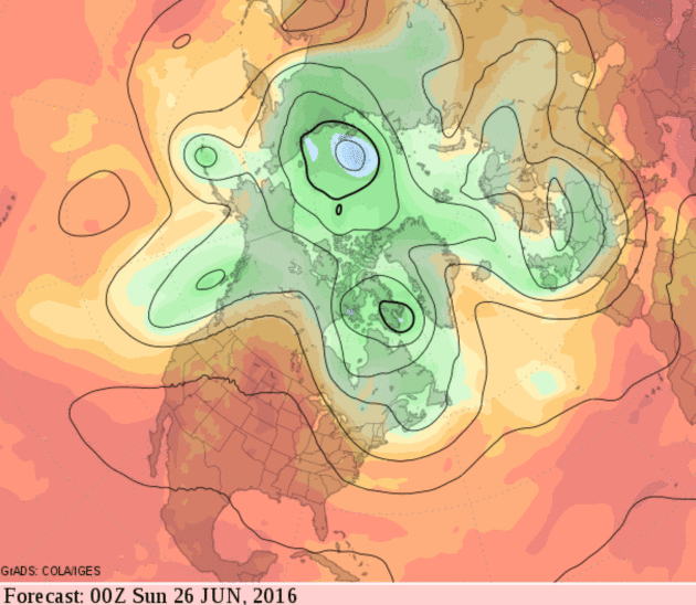
Late-June Warming Trend.
If the forecast for 500 mb winds (GFS) actually verifies 2 weeks from
now daytime highs will consistently be in the 80s with a few 90s
possible as a hot ridge of high pressure sets up over the central USA.
From Frost to Heat Advisories in Less Than One Week. Dr. Mark Seeley has details on the frost event that took place just 3-4 days ago up north in this week's edition of
Minnesota WeatherTalk; here's a clip: "
June
7 and 8 brought cold morning temperatures to many parts of the state,
especially northeastern counties. Many climate observers reported
morning lows in the 30s F, and several reported frost. A number of
climate stations also reported new record daily low temperatures. These
included:
June 7th 37F at Kabetogama and Littlefork
June 8th: 28F at Crane Lake; 29F at Hibbing and Orr; 30F at International Falls and Babbitt; and 37F at Sandstone.
Actually
frosts this time of year are not all that unusual in northern Minnesota
counties, with a 10 to 20 percent historical frequency during the 2nd
week of June..."
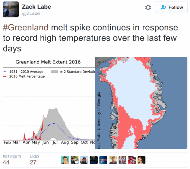
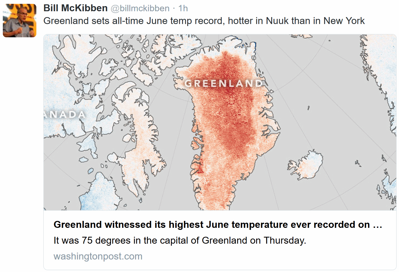 Warmest June Temperature on Record for Greenland
. Details via
The Capital Weather Gang.
Heat Soars to Record Levels Across West, Heads East. Here are a few interesting weather nuggets in a story at
WXshift: "...
Several
spots in the West set new high temperature records last week. Phoenix
is normally hot this time of year, with a normal high of 102°F (39°C),
but there were four consecutive days (June 3-6) when the high was more
than 110°F (43°C). Each of those four days brought a new record high,
with the temperature peaking at 115°F (46°C) on June 4. Even
traditionally cooler spots of the Pacific Northwest have been especially
hot. According to the National Weather Service in Seattle,
the average temperature for the first week in June this year has been
the second hottest since the 1890s. Similarly, the high of 84°F (29°C)
on June 7 marked the 14th day that was 80°F (26.7°C) or warmer this
year. The record for the most days at or above 80°F by the end of June
is 15, which was set just last year..."
Image credit: NOAA.
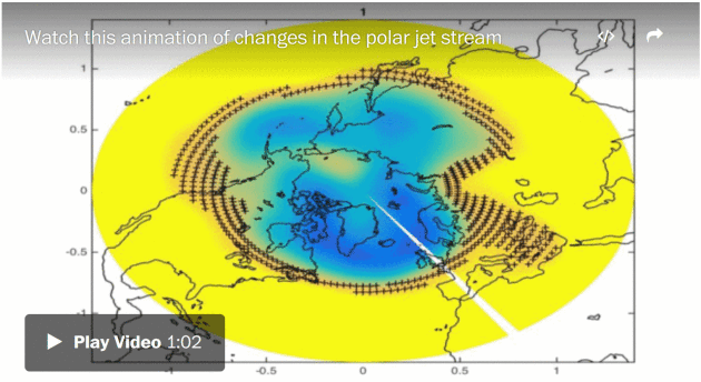
Weird Jet Stream Behavior Could Be Making Greenland's Melting Even Worse, Scientists Say. Here's an excerpt of a Chris Mooney story at The Washington Post: "...I
think we can start to connect these dots and say that increasing loss
of Arctic sea ice is leading to more blocking patterns, which are
contributing to the increasing surface melt on Greenland,” said Jennifer
Francis, the Rutgers University Arctic expert whose ideas about Arctic
melting distorting the jet stream have ignited one of the biggest
ongoing debates in climate science, and who is familiar with the new
study by Tedesco and his colleagues. “Of course, this is bad news for
sea-level rise and maybe also for the ocean circulation as the extra
meltwater appears to be partially responsible for the ‘Cool Blob’ south
of Iceland...”
* The new paper referenced in the previous story is
here.
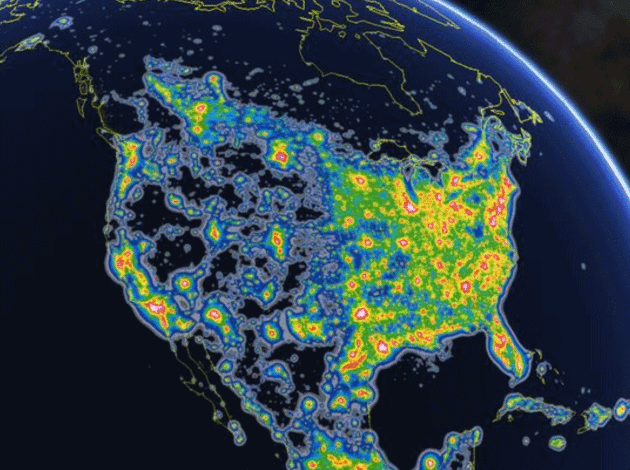
Study: Light Pollution Blocks Milky Way for Nearly 80% of Americans.
USA TODAY reports: "
Light
pollution now blocks the Milky Way galaxy in the night sky for nearly
80% of Americans and more than one-third of the world, according to a
study and global atlas released Friday. Overall, more than 99% of
Americans live under light-polluted skies, and some spots in the USA may
never again experience a true night thanks to the perpetual, artificial
light. The phenomenon isn't new: Lighting of homes, streets, highways
and bustling cities across the nation grew dramatically after World War
II, said Chris Elvidge, a scientist at the National Oceanic and
Atmospheric Administration’s (NOAA) National Center for Environmental
Information..."
Image credit: "
A light pollution map of North America shows that nearly the entire eastern U.S. is artificially brightened at night."
(Photo: Fabio Falchi)
 Air Pollution Now Major Contributor to Stroke, Global Study Finds
. Here's a summary of new findings reported at
The Guardian: "
Air
pollution has become a major contributor to stroke for the first time,
with unclean air now blamed for nearly one third of the years of healthy
life lost to the condition worldwide. In an unprecedented survey of
global risk factors for stroke, air pollution in the form of fine
particulate matter ranked seventh in terms of its impact on healthy
lifespan, while household air pollution from burning solid fuels ranked
eighth..."
 The World's Population is Very Slowly Backing Away from the Dangerous Coasts.
Although growth and development continues to accelerate, new research
suggests the growth in population is slowly spreading away from the
coasts, as highlighted at
Co.Exist: "...
As
of 2010, they found that about 1.9 billion people, or 27% of the
world’s population, lived on the 9% of the planet’s land that is near
the coast (defined as less than 100 kilometers from the shore at lower
than 100 meters elevation). Seventeen out of 30 of the world’s largest
cities are in this area, too. These population estimates come out
slightly higher than previous research done in the 1990s, so the authors
believe there is even more human pressure on coastal areas than we
realize..." (Photo credit: May S. Young, Flickr).
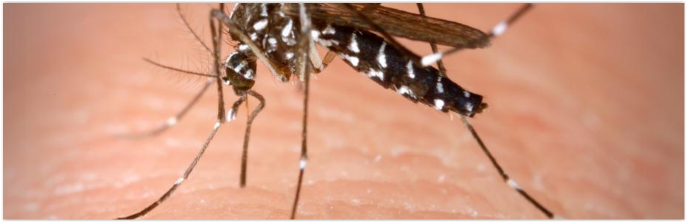
Delay Pregnancy in Areas With Zika, W.H.O. Suggests. Huh? Here's the intro to a New York Times story: "People living in areas where the Zika virus is circulating should consider delaying pregnancy to avoid having babies with birth defects, the World Health Organization has concluded. The advice affects millions of couples in 46 countries across Latin America and the Caribbean where Zika transmission is occurring or expected. According to a recent study,
more than five million babies are born each year in parts of the
Western Hemisphere where the mosquitoes known to spread the virus are
found..."
Image credit: Climate Nexus.
Every Company is a Technology Company. Amen to that.
Fortune has important perspective that rings true; here's an excerpt: "...
Herein,
as you’ll see, lies a lesson (or several). In today’s economy almost
every big company, even one selling dental drills, is on a journey of
digital transformation. Cloud and mobile computing, ubiquitous sensors
producing endless streams of data, and ever more intelligent algorithms
have created the potential to transform nearly every aspect of nearly
every business. Getting ahead in the digital journey can lead to outsize
success, as the Henry Schein story illustrates. Falling behind, in a
race with winner-take-most dynamics, can cause fatal disruption..."
 TODAY
TODAY: Sticky, few showers and T-storms. Winds: SE 10-20. High: 82
SUNDAY NIGHT: Muggy with showers and storms, locally heavy rain. Low: 67
MONDAY: Clouds and showers linger. Winds: NW 8-13. High: 81
TUESDAY: More showers and T-storms move in. Winds: E 10-15. Wake-up: 64. High: 76
WEDNESDAY: Showers and storms slowly taper. Winds: NW 10-20. Wake-up: 62. High: 72
THURSDAY: Partly sunny, drying out. Winds: NE 10-15. Wake-up: 58. High: 75
FRIDAY: Sunny and warmer. Winds: SE 5-10. Wake-up: 57. High: 82
SATURDAY: Sticky sun, feels like summer again! Winds: S 10-15. Wake-up: 62. High: 85
Climate Stories...
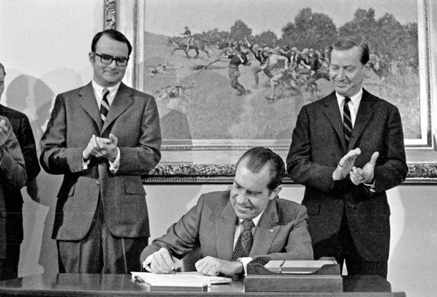
Dear Conservatives, You Can Go Green Again. If conservatives don't conserve - across the board - a major rebranding effort will soon be required. Here's an excerpt from
The New York Times: "...
Conservatives may complain about oil companies being shut out of the Arctic National Wildlife Refuge,
but most of the credit for protecting that habitat belongs to Dwight D.
Eisenhower, who also signed the nation’s first air pollution control
law. Richard M. Nixon, not otherwise a candidate for sainthood, changed
the way the nation lives, breathes and does business, establishing the
Environmental Protection Agency and enacting the Clean Air Act and the
Endangered Species Act, among other major environmental initiatives.
George H. W. Bush, finally, began to take conservation in a new
market-based direction, pushing through a cap-and-trade system in 1990
that enabled industry to reduce sulfur dioxide emissions, which causes
acid rain, far more quickly and cheaply than anyone imagined possible..."
Photo credit: "
President Richard M. Nixon signing pollution legislation." Credit Associated Press.
This Might Get the World to Finally Pay Attention to Climate Change. Gizmodo has the eye-opening report; here's an excerpt: "
Six
British warships stationed in the Persian Gulf are breaking down
because the water is too hot. This week, members of the British Navy testified to the UK’s Defence Committee that
their Type 45 destroyers keep losing power because of high ocean
temperatures. When the ships’ turbines get overheated, they can’t
generate as much energy, resulting in electrical failures. The makers of
the billion-dollar warships, including Rolls-Royce and BAE Systems
Maritime, claim that the ships were not designed to be used in that kind
of environment for an extended amount of time, although they are
supposedly engineered for a wide range of temperatures from sub-Arctic
to tropic..."
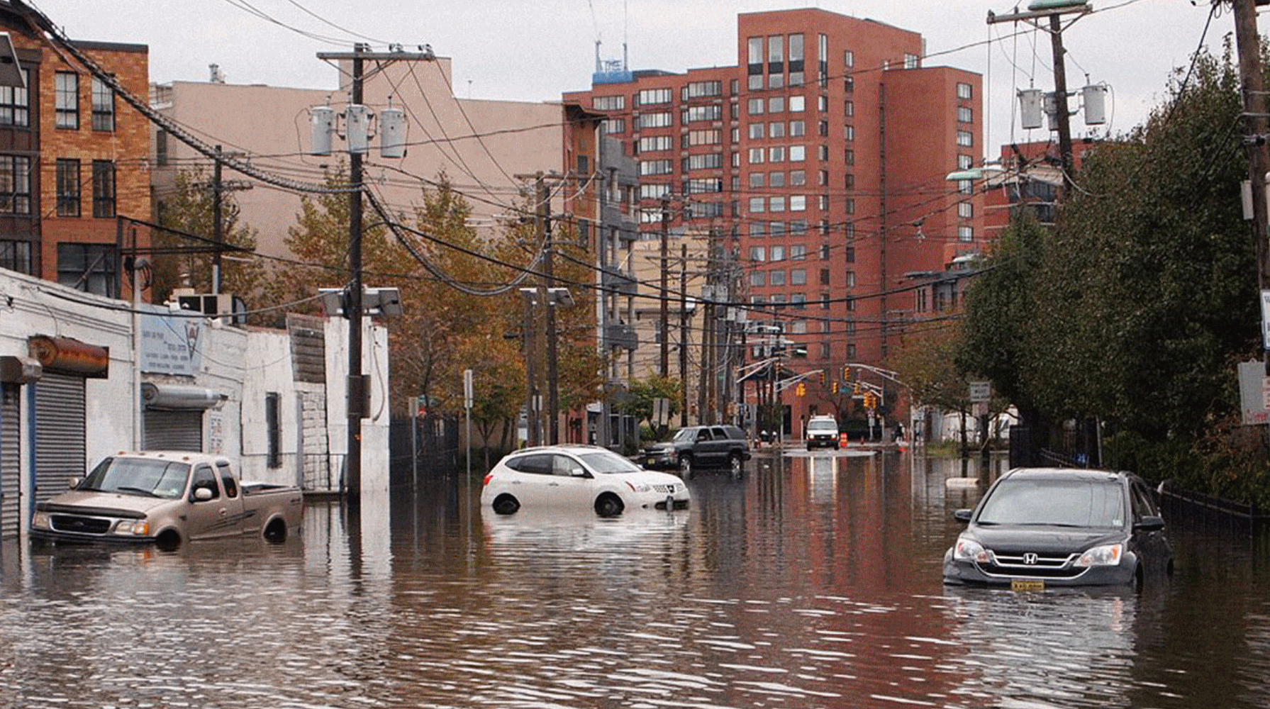
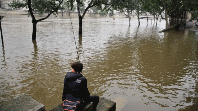
Paris Floods Were "Directly" Tied to Global Warming, Study Finds. Another
atmospheric fluke? Probably not, as the weather-dice are increasingly
loaded for freakish flood events. Here's an excerpt of an Andrew
Freedman analysis at
Mashable: "
The
water is still receding along the Seine and Loire Rivers in France,
with cleanup beginning in parts of Bavaria, but scientists are already
out with a study showing that global warming made the floods at the end
of May and early June far more likely compared to a climate that had not
warmed due to greenhouse gas emissions. The analysis, which is known as
an extreme event "attribution study," found that the probability of
three-day precipitation extremes in April through June increased by at
least 40% in France overall due to climate change, with about an 80%
increase in likelihood along the Seine River Basin and close to a 90%
increase in the Loire River Basin..."
Photo credit: "
A boy fishes in the Seine river during floods, in Paris, Sunday, June 5, 2016." Image: Thibault Camus/AP.
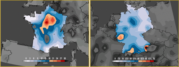
Historic May Rainfall Event Across Europe. Here is an excerpt of the report from Climate Central's
World Weather Attribution unit: "..
.Overall,
the probability of 3-day extreme rainfall in this season has increased
by at least 40 percent in France, with the best estimate of about 80
percent on the Seine and about 90 percent on the Loire. All four climate
model ensembles that simulated the statistical properties of the
extremes are in good overall agreement. Results for Germany were
inconclusive. Based on these different approaches — all of which are in
agreement — the team found that global warming increased the likelihood
of the heavy rains associated with the May 29 – 31 event in both the
Seine and the Loire River basins. Return Times: We find that the 3-day
precipitation in the Seine basin was very rare in April–June, with a
return time of roughly one in hundreds of years. The event was less
rare on the Loire, with a return time of roughly 1 in every 50 years..."
Map credit: "
Map
of mean rainfall (in mm) for the 3-day period from May 29 – 31, 2016
over France. b) Map shows 1-day maximum precipitation total (in mm) from
Jan. to June 5th, 2016 over Germany." Source: NOAA/NCEP/CPC.
* More perspective on severe weather attribution in a warming atmosphere from
The New York Times.


No comments:
Post a Comment