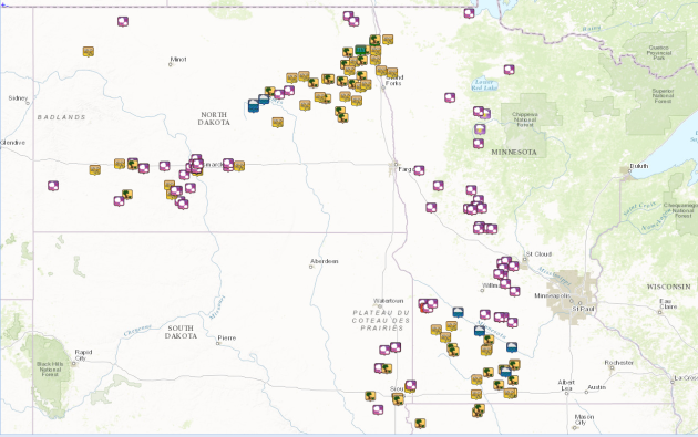
Wild Storms on Friday
Take
a look at the storm report map from late Thurdsay night through Friday
night. Interestingly, a line of storms started in western North Dakota
on Thursday night and moved through Bismarck, ND with up to 3.25"
diameter hail. It then moved into NW Minnesota with up to 80mph before
dropping almost straight south into SW Minnesota with a number of large
hail and damaging wind reports through the rest of the day Friday. Other
than a few light rain showers, the Twin Cities didn't see much of
anything.
...PORTIONS OF MT EWD TO NRN MN...
   SHOWERS AND SCATTERED THUNDERSTORMS MAY BE ONGOING AT THE START OF
   THE PERIOD OVER ERN PORTIONS OF THE RISK AREA -- I.E. PORTIONS OF
   THE DAKOTAS AND MN VICINITY -- INVOF THE TRAILING/W-E PORTION OF A
   CANADIAN COLD FRONT PROGGED TO HAVE SAGGED SWD INTO THE REGION.
   THIS CONVECTION COULD PERSIST AND/OR INCREASE INTO THE
   AFTERNOON...AS THE FRONT LINGERS AND HEATING OF THE MOIST BOUNDARY
   LAYER YIELDS MODERATE DESTABILIZATION.  GIVEN ENHANCED WSWLYS
   ALOFT...SOME RISK FOR ISOLATED SEVERE STORMS IS APPARENT -- THOUGH
   CONDITIONAL UPON THE PRESENCE OF CONVECTION WITHIN THE OTHERWISE
   WEAKLY FORCED/WEAKLY RIDGING ENVIRONMENT ACROSS THIS PORTION OF THE
   AREA DURING THE AFTERNOON.
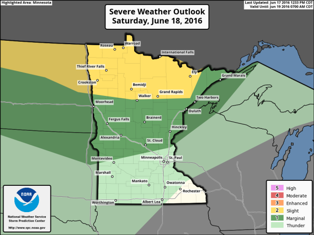
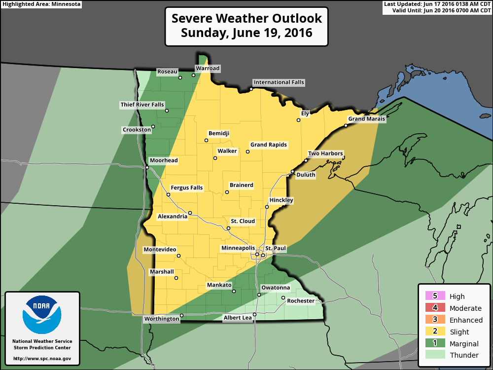
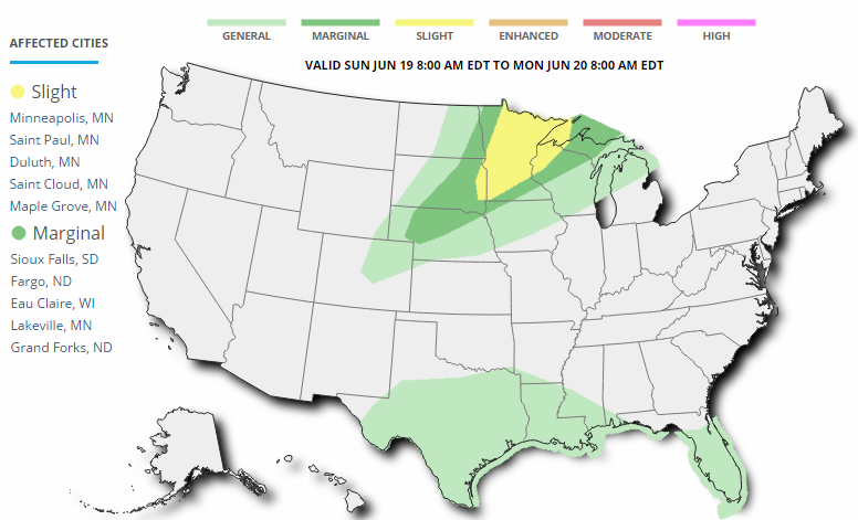
Severe Threat Sunday
...NRN PLAINS AND UPPER MS VALLEY...
   EARLY STORMS ARE EXPECTED TO BE ONGOING ACROSS NRN MN NEAR A SFC LOW
   WHICH WILL MOVE N OF THE CANADIAN BORDER BY AFTERNOON. THIS ACTIVITY
   MAY POSE A HAIL OR WIND THREAT. LATER IN THE DAY...A COLD FRONT WILL
   PUSH EWD...EXTENDING FROM CNTRL NEB INTO CNTRL MN BY 00Z. STRONG
   INSTABILITY IS FORECAST E OF THE FRONT...BUT THE MAIN LIFTING
   MECHANISM WILL BE N OF THE AREA. STILL...CONVERGENCE ALONG THE FRONT
   SHOULD RESULT IN AT LEAST ISOLATED SEVERE STORMS. STRONG MEAN WIND
   FIELDS AND THE LINEAR FORCING MECHANISM SUGGESTS A POSSIBLE LINE OF
   CELLS AND/OR A LINEAR MODE WITH WIND AND HAIL POSSIBLE.
_____________________________________
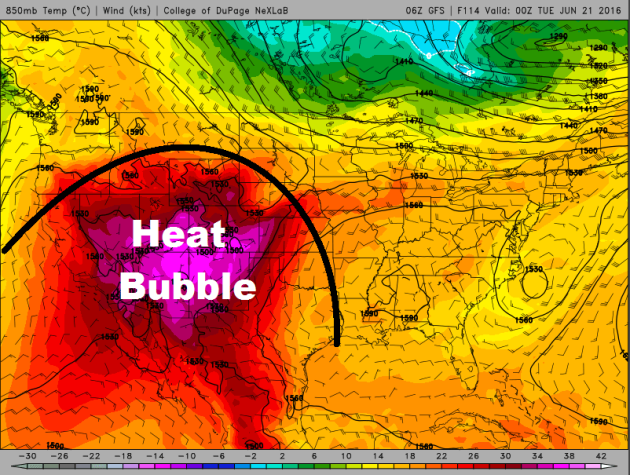
Excessive Heat Building in the Southwest
The
dome of hot weather will continue to build across the Southwestern part
of the nation with some spots nearing all-time record highs Sunday
and Monday.
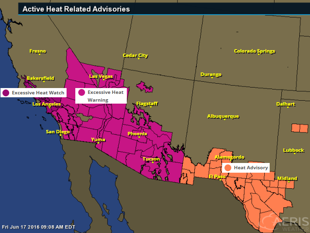
Excessive Heat Watches and Warnings
The
National Weather Service has issued a number of excessive heat watches
and warnings across the Southwest, which includes major cities like Los
Angeles, Las Vegas, Phoenix, Tucson and Yuma.
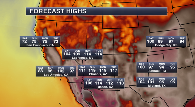
Potential High Temperatures & Stats
Phoenix, AZ
-
Highs will approach 120 on both Sunday and Monday. Phoenix has only had
a high of 120 or higher three times in their recorded history (since
1895).
- The last time Phoenix hit 120 or higher was back on July 28, 1995 when the thermometer hit 121.
- Whether the temperature touches 120 or not, record highs are likely. The current record high each day between Saturday and Tuesday is 115.
- The last time Phoenix hit 120 or higher was back on July 28, 1995 when the thermometer hit 121.
- Whether the temperature touches 120 or not, record highs are likely. The current record high each day between Saturday and Tuesday is 115.
Tucson, AZ
-
We are calling for a forecast high of 114 on Sunday. Only seven times
in Tucson recorded history (since 1894) has the city seen a high of 114
or higher – the last time occurring on July 28, 1995 when it also
reached 114.
- The all-time record in Tucson history is 117 set back on June 26, 1990.
- Record highs over the weekend and into next week are 113 Saturday, 112 Sunday, 110 Monday and 112 Tuesday.
- The all-time record in Tucson history is 117 set back on June 26, 1990.
- Record highs over the weekend and into next week are 113 Saturday, 112 Sunday, 110 Monday and 112 Tuesday.
Las Vegas, NV
-
Las Vegas is no stranger this type of higher heat in the forecast,
reaching a temperature of 115 or higher 55 times since 1937. The last
time Las Vegas saw a high of 115 or higher was back on July 2, 2013.
- The warmest high ever in Las Vegas history is 117 reached three times in their history. The most recent occurrence was back on June 30, 2013.
- Our forecast has Las Vegas reaching 114 both Monday and Tuesday next week.
- Record highs this weekend into next week are 115 Saturday, 114 Sunday, 113 Monday and 111 Tuesday.
Los Angeles, CA
- Even Los Angeles will get in on the heat this week into early next week, reaching at least the mid 90s Sunday through Tuesday.
- We could even see highs in downtown Los Angeles break the triple-digit mark next Monday. Down toward LAX, highs Monday will be near 90, which could break the record for the day of 86.
- We could even see highs in downtown Los Angeles break the triple-digit mark next Monday. Down toward LAX, highs Monday will be near 90, which could break the record for the day of 86.
(Image and stats courtesy: DJ Kayser @DKayserWX)
Grandma's Marathon - Hot and Sticky for Dad's Day
By Todd Nelson, filling in for Douglas.
Somewhat unsettled weather takes us into the last weekend of Spring 2016 as the summer solstice arrives on Monday at 5:34pm CDT. With that said, it'll feel very much like summer this Father's Day weekend with high temps on Sunday warming into the 90s and tropical dewpoints nearing 70 degrees. It'll be a sweat box for sure, hope you can find some A/C!
Scattered showers and storms will have no problem developing on the northern periphery of this hot dome through the weekend, so have a plan 'B' if skies look threatening. A few strong storms fire in northern MN on Saturday, while most of the state sees an increasing strong thunder risk late Sunday.
___________________________
Extended Forecast
FRIDAY NIGHT: Mostly cloudy. Winds: SSE 5-10. Low: 67.
SATURDAY: Feels like summer. More storms N. Winds: SSW 5-10. High: 86
SATURDAY NIGHT: Partly cloudy with a few stray storms. Winds: S 5. Low: 68
SUNDAY: Hot & sticky Father's Day. Heavy storms late (some severe?). Winds: SSW 10-20. Wake-up: 68. High: 92
MONDAY: Summer begins. Less muggy, stray storm. Winds: WNW 10-20. Wake-up: 62. High: 80
TUESDAY: Beautiful! Low humidity and bright sun. Winds: NW 5-10. Wake-up: 59. High: 76
WEDNESDAY: Few clouds, fresh breeze. Winds: NNE 5. Wake-up: 57. High: 76
THURSDAY: A touch warmer. Still mostly dry. Winds: SW 5. Wake-up: 60. High: 80.
FRIDAY: Humidity returns. Spotty PM thunder? Winds: S 5-15. Wake-up: 60. High: 80
______________________________
______________________________
This Day in Weather History
June 18th
1939: A deadly tornado hits Anoka. 9 fatalities and over 200 injuries are reported.June 18th
1850: Territorial Governor Ramsey reports that about halfway between Ft. Ripley and Ft. Snelling on the Mississippi a severe hail storm occurred in the evening. One or two hailstones picked up were as large as hen’s eggs and he thought he saw one about the size of a 'musket ball.'
_______________________________
Average High/Low for Minneapolis
June 18th
June 18th
Average High: 80F (Record: 98F set in 1953)
Average Low: 60F (Record: 39F set in 1876)
________________________________
Average Low: 60F (Record: 39F set in 1876)
________________________________
Sunrise/Sunset Times for Minneapolis
June 18th
June 18th
Sunrise: 5:26am
Sunset: 9:02pm
Sunset: 9:02pm
*Daylight gained since yesterday: ~11seconds
*Daylight gained since Winter Solstice (December 22nd): ~6hours and 51mins
__________________________________
*Daylight gained since Winter Solstice (December 22nd): ~6hours and 51mins
__________________________________
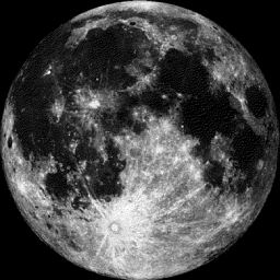
Moon Phase for June 18th at Midnight
1.2 Days Until Full (Strawberry) Moon
1.2 Days Until Full (Strawberry) Moon
____________________________________
Extended Outlook
More
Heat on the way? Here's the extended forecast depicted from the ECMWF
model, which suggests another hot front arriving on Father's Day Sunday
with high temperatures getting to near 90F! However, it doesn't appear
to last too long as highs much of next week look to settle into the
low/mid 80s.
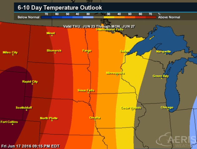
6 to 10 Day Temperature Outlook
According
to NOAA's CPC, the 6 to 10 day temperature outlook suggests above
average temperatures returning to the Midwest from June 23rd -
27th. Side note; the Summer Solstice is Monday, June 20th!
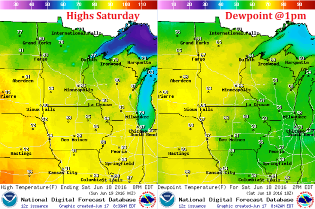
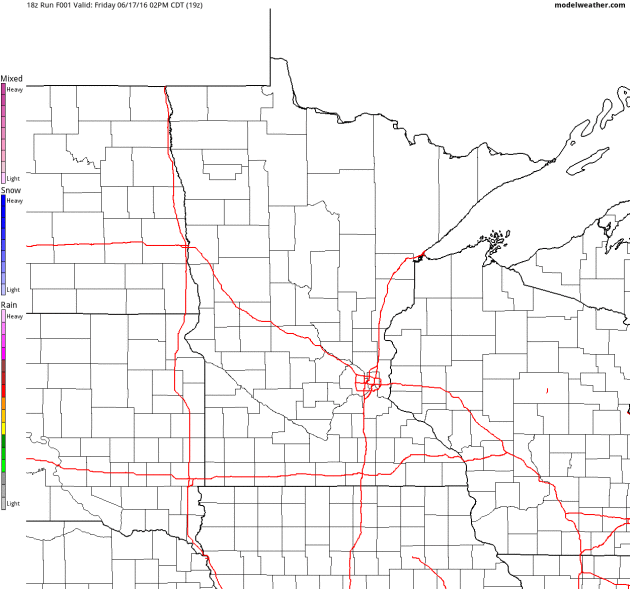
Saturday Weather Outlook
Temperatures
on Saturday will be a bit warmer than they were on Friday across much
of the state. Note that some mid to upper 80s will be found across the
southern half of the state, while muggy dewpoints return and slide up
into the 60s across much of the state.
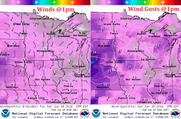
Saturday Weather Outlook
A light southerly wind will continue across the state on Saturday with stronger winds found across the Dakotas.
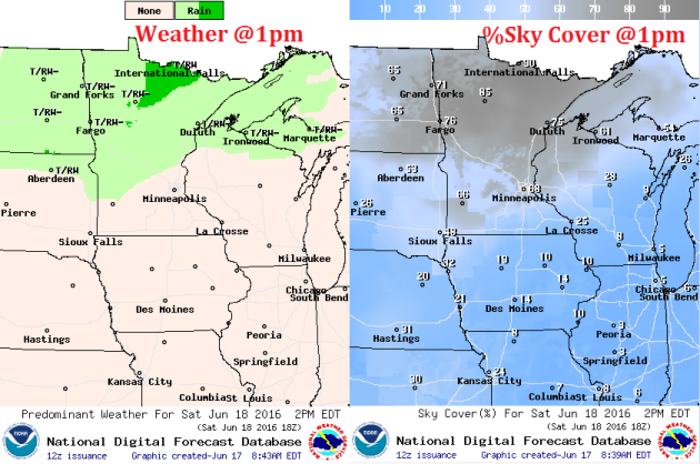
Saturday Weather Outlook
Scattered
showers and storms will be found across the northern half of the state
on Saturday, while areas across the southern half of the appear to be
quiter with more sunshine.
Simulated Radar
The
simulated radar through PM Sunday suggests ongoing showers and storms
across the northern half of the state on Saturday with a better chance
of storms across the rest of the state on Sunday.
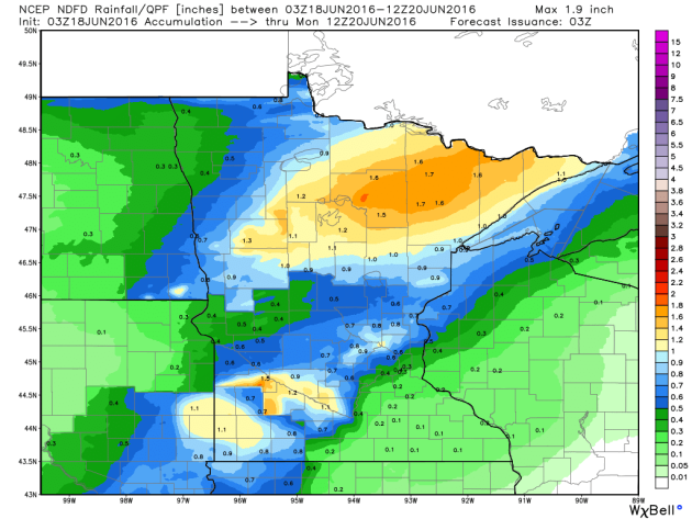
Rainfall Potential
Rainfall
potential through AM Monday suggests heavier rainfall across western
and northern Minnesota . This heavier rainfall potential will be
associated with scattered showers and storms that will be on and off
through the weekend.
___________________________________
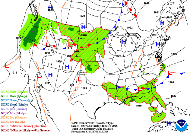
National Weather Outlook
A
storm system moving into the Western U.S. that brought snow to parts of
the northern Sierra Nevada range will wash out a bit through early
weekend. As this happens, dangerous heat begins develop in the Southwest
through early next week. Meanwhile, scattered showers and storms will
be possible across parts of the Midwest through the early weekend.
Severe Threat Saturday
...SUMMARY...
   THUNDERSTORMS CAPABLE OF PRODUCING VERY LARGE HAIL AND STRONG WIND
   GUSTS ARE POSSIBLE LATE SATURDAY AFTERNOON INTO SATURDAY NIGHT FROM
   NORTHERN MONTANA ACROSS NORTH DAKOTA...AND ACROSS PARTS OF NORTHERN
   MINNESOTA DURING THE DAY. A FEW STRONG STORMS CANNOT BE RULED OUT
   OVER LOUISIANA AND SOUTHERN MISSISSIPPI DURING THE DAY.

   ...SYNOPSIS...
   GRADUAL DEAMPLIFICATION OF THE LARGE-SCALE PATTERN IS PROGGED ACROSS
   THE U.S. THIS PERIOD...AS A TROUGH CONTINUES TO EXIT THE E COAST AND
   PROGRESS INTO THE WRN ATLANTIC.  AS THIS OCCURS...BROAD/FLAT RIDGING
   WILL EXPAND TO ENCOMPASS MUCH OF THE COUNTRY...EVEN TO THE EXTENT OF
   HINDERING THE INLAND ADVANCE OF AN UPPER LOW OFF THE PAC NW COAST AT
   THE START OF THE PERIOD.  BY THE END OF THE PERIOD...THIS LOW IS
   PROGGED TO HAVE BEEN SHUNTED NEWD TO THE WA/NRN ID/SRN BRITISH
   COLUMBIA VICINITY...WHILE A BROAD ZONE OF ENHANCED WSWLY FLOW /ON
   THE NRN SIDE OF THE FLAT U.S. RIDGE/ EXTENDS FROM THE NWRN U.S.
   ENEWD ACROSS THE U.S./CANADA BORDER REGION AND INTO QUEBEC/ONTARIO.

   AT THE SURFACE...A COLD FRONT IS EXPECTED TO HAVE SAGGED SWD INTO
   THE NRN PLAINS VICINITY...BUT SHOULD BEGIN RETREATING NWD AS A
   DEVELOPING SURFACE CYCLONE SHIFTS EWD ACROSS MT DURING THE DAY IN
   RESPONSE TO THE AFOREMENTIONED PAC NW UPPER SYSTEM.  AS THIS LOW
   ADVANCES ENEWD THROUGH THE SECOND HALF OF THE PERIOD...A TRAILING
   COLD FRONT WILL ADVANCE SEWD ACROSS THE INTERMOUNTAIN W...WITH THE
   LOW AND NRN PORTION OF THE FRONT REACHING THE NRN PLAINS HIGH PLAINS
   BY THE END OF THE PERIOD.
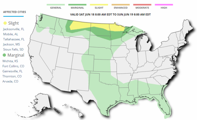
Severe Threat Sunday
...SUMMARY...
   SCATTERED SEVERE STORMS ARE POSSIBLE SUNDAY FROM THE EASTERN DAKOTAS
   ACROSS MUCH OF MINNESOTA AND INTO NORTHWEST WISCONSIN WITH HAIL AND
   WIND EXPECTED.

   ...SYNOPSIS...
   A STRONG BUT LOW-AMPLITUDE SHORTWAVE TROUGH WILL SKIRT THE NRN
   PLAINS ON SUNDAY WITH SURFACE LOW MOVING FROM ND INTO ONTARIO AND A
   COLD FRONT EXTENDING SWWD INTO THE NRN PLAINS AND UPPER MS VALLEY.
   THIS FRONT WILL PROVIDE A FOCUS FOR A FEW SEVERE STORMS...SUPPORTED
   BY STRONG WIND FIELDS ALOFT AND AMPLE MOISTURE AND INSTABILITY.
   MEANWHILE...AN UPPER HIGH WILL REMAIN OVER THE FOUR CORNERS
   STATES...WITH GENERAL THUNDERSTORMS ALONG THE GULF COAST S OF THE
   RIDGE.
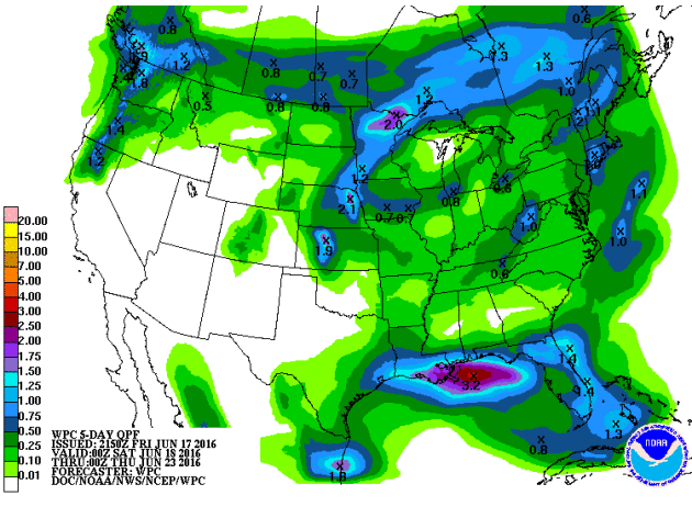
5 Day Rainfall Potential
According
to NOAA'S WPC, the 5 day rainfall forecast suggests heavier pockets of
rain across parts of the northern tier of the nation through the
Mid-Atlantic states and into the Southeastern U.S.. Keep in mind that
with thunderstorm activity, some locations could see 1" to 2"+ through
the end of the weekend.
__________________________________
"Kerry tours Arctic Circle to see climate change impact"
NY-ALESUND,
Norway — U.S. Secretary of State John Kerry on Thursday visited
Norway’s extreme north, viewing areas where climate change has melted
ice and opened new sea lanes. Trailed by staff and journalists in small
Zodiac-type inflatable boats, Kerry and Norway’s foreign minister
motored in an Arctic scientific vessel from a research station in
Ny-Alesund, the world’s northernmost civilian settlement. The short
cruise took Kerry and his delegation across the iceberg strewn
Kongsifjorden (King’s Bay Fjord), where puffins and other Arctic birds
skirted the waters, to the Blomstrand Glacier. The glacier has receded
significantly in the past 25 years to 30 years, with summer temperatures
that can now be 8 degrees and 11 degrees higher than they once were,
according to Jan-Gunnar Winther, the director of the Norwegian Polar
Institute, who guided Kerry and Foreign Minister Borge Brende.
(U.S.
Secretary of State John Kerry (L) stands with Norwegian Foreign
Minister Borge Brende as he boards his plane in Oslo for a trip to view
the Blomstrand Glacier, and areas impacted by climate change in Norway’s
extreme north, June 16, 2016. Photo by Evan Vucci/Pool/Reuters)

________________________________________
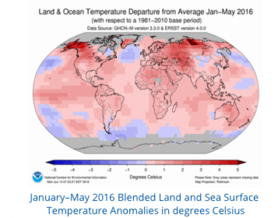
"May 2016 sets new records"
Global
temperature records were broken yet again in May 2016, according to
data just released by NASA, and the US National Oceanic and Atmospheric
Administration, which also reported that it was the hottest (northern
hemisphere) spring on record. The year to date is also the hottest on
record. NOAA reported that the
atmospheric concentration of carbon dioxide, which is driving global
warming, passed 400 parts per million on 23 May at the South Pole – the
last place on earth to breach the milestone.
After five consecutive record months it comes to no surprise that the average global land and ocean surface temperature for January–May 2016 resulted in the warmest such period on record across the world's land and ocean surfaces, at 1.08°C (1.94°F) above the 20th century average of 13.1°C (55.5°F), surpassing the previous record set in 2015 by 0.24°C (0.43°F), according to NOAA
The heat has been especially pronounced in the Arctic, resulting in a very early onset of the annual melting of Arctic sea ice and the Greenland ice sheet. Snow cover in the northern hemisphere was exceptionally low.
“The rapid changes in the Arctic are of particular concern. What happens in the Arctic affects the rest of the globe. The question is will the rate of change continue? Will it accelerate? We are in uncharted territory.”
Read more from the World Meteorological Organization HERE:
________________________________________Race to save hidden treasures under threat from climate change
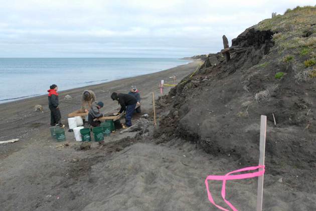
Thousands of ancient treasures that have been unearthed by climate change could soon be lost to humankind forever, as they are eroded by weathering and eaten by pests. The crisis is so extreme that some archaeologists are urging colleagues to abandon their current field sites and focus instead on these newly exposed relics before they vanish. Rising seas, raging storms, melting ice and forest fires are revealing artefacts that have much to tell us about our history on Earth – from sunken shipwrecks in Svalbard to the ancient waste dumps filled with bones, shoes and carvings emerging all over the Arctic and further south, including in Scotland. “This material is like the library of Alexandria. It is incredibly valuable and it’s on fire now,” George Hambrecht, an anthropologist at the University of Maryland, College Park, told New Scientist at the Anthropology, Weather and Climate Change conference held in London last month.
Read more from Newscientist.com HERE:
 _________________________________________
After five consecutive record months it comes to no surprise that the average global land and ocean surface temperature for January–May 2016 resulted in the warmest such period on record across the world's land and ocean surfaces, at 1.08°C (1.94°F) above the 20th century average of 13.1°C (55.5°F), surpassing the previous record set in 2015 by 0.24°C (0.43°F), according to NOAA
The heat has been especially pronounced in the Arctic, resulting in a very early onset of the annual melting of Arctic sea ice and the Greenland ice sheet. Snow cover in the northern hemisphere was exceptionally low.
“The rapid changes in the Arctic are of particular concern. What happens in the Arctic affects the rest of the globe. The question is will the rate of change continue? Will it accelerate? We are in uncharted territory.”
Read more from the World Meteorological Organization HERE:
________________________________________Race to save hidden treasures under threat from climate change
Thousands of ancient treasures that have been unearthed by climate change could soon be lost to humankind forever, as they are eroded by weathering and eaten by pests. The crisis is so extreme that some archaeologists are urging colleagues to abandon their current field sites and focus instead on these newly exposed relics before they vanish. Rising seas, raging storms, melting ice and forest fires are revealing artefacts that have much to tell us about our history on Earth – from sunken shipwrecks in Svalbard to the ancient waste dumps filled with bones, shoes and carvings emerging all over the Arctic and further south, including in Scotland. “This material is like the library of Alexandria. It is incredibly valuable and it’s on fire now,” George Hambrecht, an anthropologist at the University of Maryland, College Park, told New Scientist at the Anthropology, Weather and Climate Change conference held in London last month.
Read more from Newscientist.com HERE:
Thanks for checking in and don't forget to follow me on Twitter @TNelsonWX

No comments:
Post a Comment