52 mph peak wind in the metro Monday morning.
71 F. high yesterday at KMSP
76 F. average high on June 6 in the Twin Cities.
79 F. high on June 6, 2015.
June 7, 1939: Grapefruit-sized hail falls in Rock County, killing hundreds of farm animals near Hills.
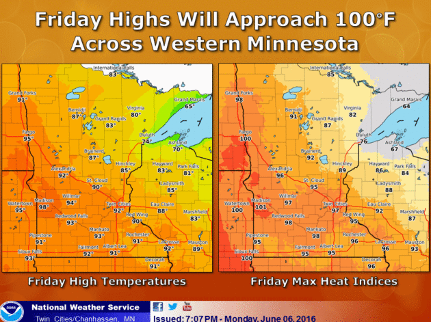
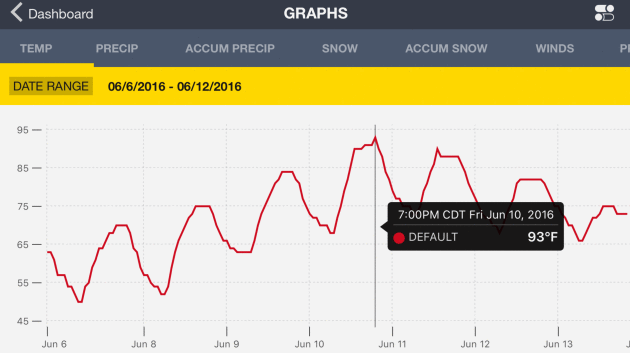
The Dog Days of June Arrive by Late Week
"Ah, summer, what power you have to make us suffer and like it" said Russel Baker.
"Ah, summer, what power you have to make us suffer and like it" said Russel Baker.
It's hard to imagine this morning, but by late week we could be looking at Heat Advisories, even an Excessive Heat Warning.
All hyperbole and exaggeration aside, it may feel 50 degrees warmer by Friday
afternoon, as the same heat bubble that has tormented Phoenix and the
Desert Southwest expands into Minnesota. Models suggest highs in the
90-95F range Friday, with a dew point in the 70s. That could create a Heat Index close to 100F. Like turning on a light switch: instant summer.
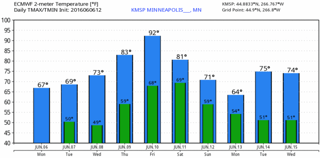
ECMWF guidance hints at a wind shift Saturday,
as a northeast breeze of Canadian heritage takes the edge off some of
the heat. But any relief will probably be temporary. A persistent bubble
of hot high pressure sets up over the central USA, meaning a streak of
80s, with a few 90s thrown in for good measure.
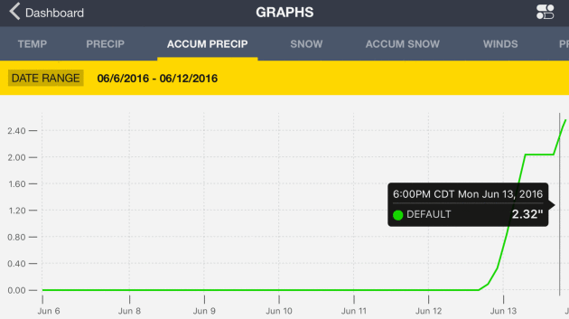
The leading edge of this free sauna may set off a stray thundershower early Thursday, with more T-storms flaring up Sunday and Monday.
Going way out on a limb: by next week you may be praying for a cooling shower.

Reviewing Heat-Related Terminology.
Thanks to the Twin Cities office of the National Weather Service for
passing along some timely reminders. The terminology below will become
increasingly relevant as the week goes on - I wouldn't be surprised to
see a Heat Advisory or Excessive Heat Watch issued on Friday:
Excessive Heat Watch (Usually issued 2-4 days ahead of time) : Forecast Conditions are favorable for the heat index to meet or exceed 100 degrees (Hennepin/Ramsey counties) or 105 (the remainder of central and south central MN and west central WI)
Excessive Heat Warning (Usually issued 1-2 days ahead of time when confidence is 80% or higher): Heat index values are forecast to reach 100 degrees Hennepin/Ramsey counties) or 105 (the remainder of central and south central MN and west central WI)
Heat Advisory: Heat index values are forecast to reach 95 degrees (Hennepin/Ramsey counties) or 100 for the remainder of central and south central MN and west central WI.
Dueling models....
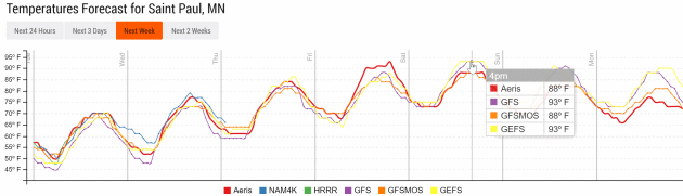

On the other hand...
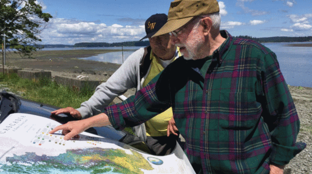
Photo credit: "David McCloskey, right, points out a feature of his map of Cascadia to a vistor at Nisqually Reach, on the southern shore of Puget Sound." (William Yardley / Los Angeles Times)
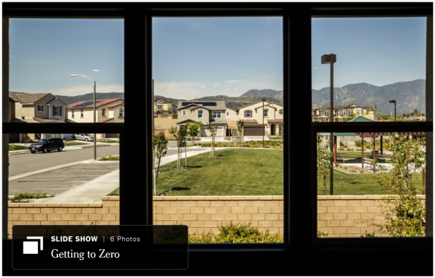
A Suburban Experiment Aims for Free Energy. Yes, free has a nice ring. Here's the intro to a New York Times story: "At
first glance, Anthony and Vanessa Genau’s home in a subdivision beneath
the San Gabriel Mountains here is like any other gracious new suburban
dwelling, with an open-plan living space, granite countertops and
stainless steel appliances. But, along with 19 other cream, taupe and
rust stucco houses that cradle the landscaped playgrounds here, it is
actually something else: a large-scale testing ground for an energy
system of the very near future. With a combination of rooftop solar
panels, smart thermostats, advanced water heaters and other
high-efficiency features, the homes are all built with a similar goal:
to make at least as much energy as they use over a year..."
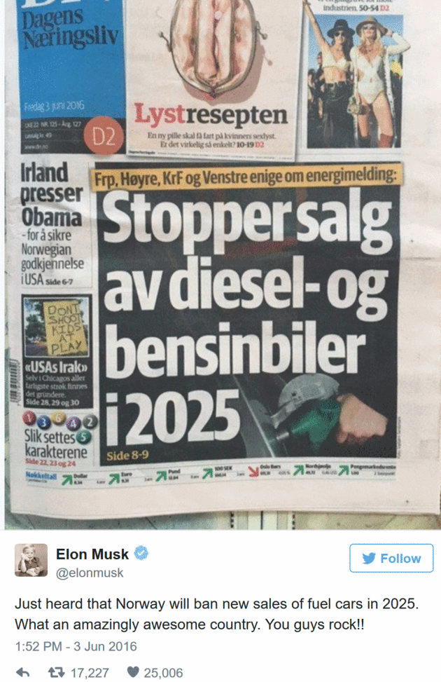
Norway Moves Towards Banning Gas-Burning Cars by 2025. Fortune reports; here's the intro: "Norway’s Dagens Næringsliv newspaper reports
that four of the country’s major parties have reached agreement on a
proposal to ban the sale of new gasoline and diesel-powered cars
starting in 2025. The proposal is not yet law, but one interested party
celebrated a little early...."

Drew Houston of Dropbox: Figure Out The Things You Don't Know. It's a pretty long list. Here's an excerpt of an interesting interview at The New York Times: "...Culture
always starts out as the sort of bizarre average of the founders’
personalities. But a couple of years ago, we decided to define our
values and make our culture explicit. There are a lot of ways to think
about it, but one of them is, how do you build something that sustains
excellence over a long period of time? Or to put it another way, it
seems that most companies, most organisms, decay as they get older and
bigger, and so how do you inoculate your company from the most common
things that tend to go wrong?..."

Take a Ride on 10 of the World's Most Mind-Blowing Elevators. Atlas Obscura takes a look at some of the more unique/obscure elevators on the planet; here's an excerpt: "...Whether
it's the gothic ironwork of Brazil's Santa Justa Lift or the futuristic
pods of the Mercedes-Benz Museum or the Aquadom lift that carries
riders straight through a massive aquarium, some elevators are so
amazing, they become destinations in and of themselves. Take a look at
10 of the world's most amazing elevators. We'll hold the door for you..."
Photo credit: Jim Woddward/CC BY 2.0

TODAY: Sunny and pleasant. Winds: NW 10-15. High: 71
TUESDAY NIGHT: Clear, still cool for early June. Low: 53
WEDNESDAY: Partly sunny and warmer. Winds: SE 5-10. High: 77
THURSDAY: Early thunder risk, then sticky sun. Winds: SE 7-12. Wake-up: 62. High: 84
FRIDAY: Sizzling sun, heat index near 100? Dew point: low 70s. Winds: S 10-15. Wake-up: 71. High: 93
SATURDAY: Wind shift, slight cooler, less humid. Winds: NE 10-15. Wake-up: 74. High: 87
SUNDAY: Sticky again, growing thunder risk. Winds: SE 10-15. Wake-up: 70. High: 84
MONDAY: Early T-storms, some may be heavy. Winds: N 8-13. Wake-up: 71. High: 82
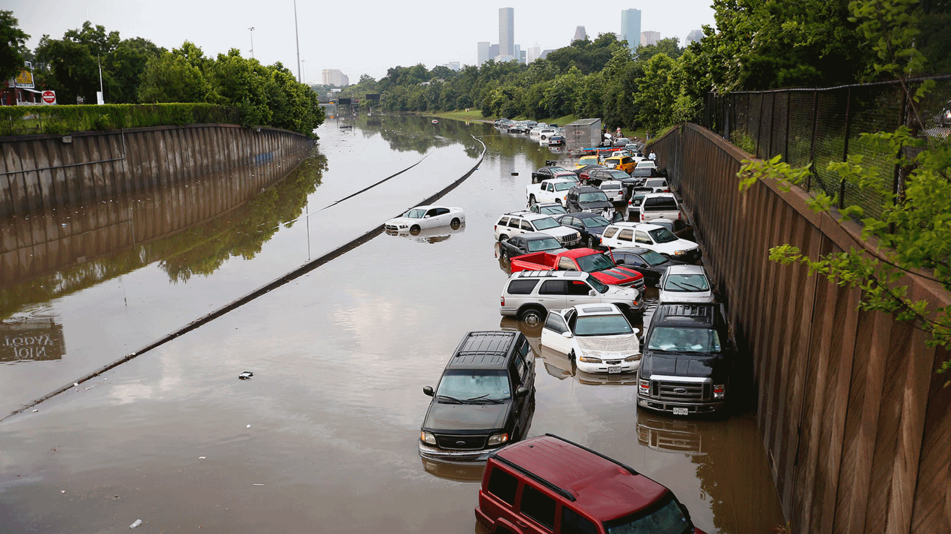
Historic Deluge Hits Texas. Houston, You Have a Problem. Here's an excerpt of an Eric Holthaus post at Slate: "...It’s impossible to know exactly how much climate change factors into the likelihood of these specific events, but it’s certain that it has. Hotter hots, drier droughts, and heavier rains have long been predicted as a consequence of rising greenhouse gas levels that speed up our planet’s water cycle and intensify many already extreme weather events. (The lingering effects of a record-setting El Niño is also likely playing a part in the recent Texas floods. And, it’s not just Texas: Over the past several days, major floods have also hit Paris and other parts of Europe, Sri Lanka, and Ethiopia.) Texas has seen some of the most drastic change in the United States, with Houston registering a 167 percent increase in the biggest downpours since the 1950s..." (2015 file photo: weather.com).
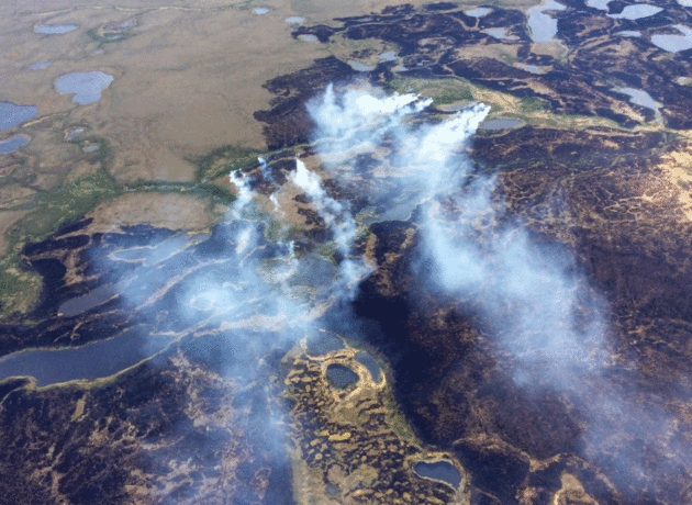
Photo credit: "In this June 2015 photo, smoke rises from the Bogus Creek Fire, one of two fires then burning in the Yukon Delta National Wildlife Refuge in southwest Alaska." (Matt Snyder/Alaska Division of Forestry via Associated Press).


Meteorologist Don Paul: How I Learned Manmade Climate Change Is The Real Deal. Here's an excerpt of Don's Op-Ed at The Buffalo News: "...When climate models are run, they can be initialized with different data sets and different levels of greenhouse gas in particular. To a model, when these models are run with the carbon dioxide level of the year approximately 1900 (around 297 ppm rather than the current 403 ppm), and natural warming (not man-made) forces are maxed up, the globe would have shown slight cooling through the end of the 20th century. Left to so-called normal cyclic changes, even with other warming mechanisms in nature pumped up, no other explanation can be found for warming that has been ongoing at different rates over recent decades..."
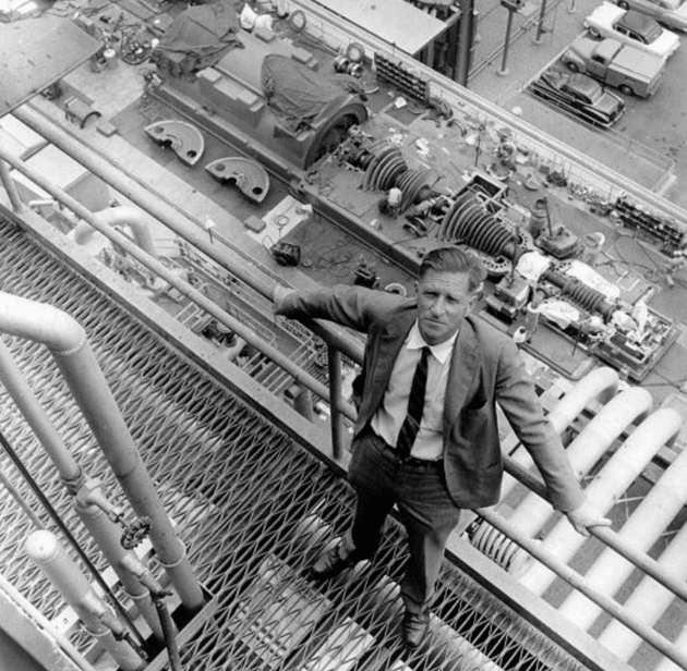
Photo credit above: "Caltech scientist Arie Haagen-Smit (pictured) discovered in the early 1950s that oil was the cause of the dangerous smog shrouding L.A. Industry then conducted its own research to discredit Haagen-Smit's findings and manufacture doubt around the link between oil and smog. It continues to fight attempts to tighten smog regulation." Photo courtesy of the California Institute of Technology.


No comments:
Post a Comment