Ducks!

Had
to include this picture in the blog of four ducks (Psyducks?) I took
out at Lake George in St. Cloud early in the day on Sunday.
_______________________________________________
90 Degree Day Check
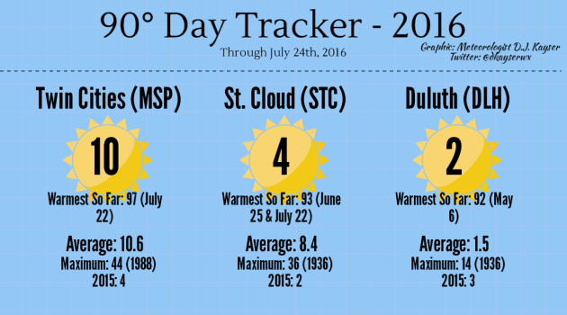
After
our stretch of heat over the past week, I thought it would be a good
time to take a look at the number of 90 degree days that certain cities
have seen across the state. Here in the Twin Cities we added three days
to the tracker over the past week, bringing our yearly number to 10 and
pretty well on par for average for the entire year. St. Cloud added two
days bringing their total up to four. Meanwhile, Duluth saw one 90
degree day last week (Friday), bringing their total above average for
the year.
_______________________________________________
One Inch Rain Days This Year
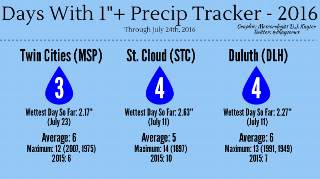
Meanwhile,
after heavy rain moved through the region on Saturday, I thought it
would also be a good time to pull out the days with 1"+ rainfall
tracker. Duluth and St. Cloud have both seen four days so far this year
with over an inch of rain - the largest of which both occurred July 11.
Meanwhile, the Twin Cities has seen three days with 1"+ of rain so far
this year, the heaviest one occurring last Saturday.
_______________________________________________
A Welcome Break from the Heat Wave This Week
By Paul Douglas
By Paul Douglas
Growing
up I played cello and bass guitar; I also learned how to write music.
I'm composing a "Sonata for Chainsaws and Sump Pumps" in honor of
Minnesota's crazy summer. 100-mph winds in Duluth; another 1 in 1,000
year flood from the Brainerd Lakes to northwest Wisconsin. Some towns
have been drenched with over 2 month's worth of rain in the last 2
weeks.
With all the bad news I'm afraid to
turn on CNN. With the recent treadmill of flooding thunderstorms I'm
afraid to turn on the Doppler. No wonder we're all freaked out.
Mother
Nature shows her benevolent side today as a bubble of high pressure
drifts overhead. That should be good for blue sky and mid-80s with a dew
point near 60F. Downright tolerable. A weak wave of low pressure kicks
up a few T-showers Tuesday night into Thursday, but skies should clear Friday
with comfortable upper 70s by late week. The weekend looks fine with
low 80s and a curious absence of monsoon rains. Models bring hotter air
into town next week; even a run of 90s by the second week of August.
Note to self: it's going to be a long, hot, sweaty summer.
_______________________________________________
Extended Forecast for Minneapolis
MONDAY: Warm sunshine. High 87. Low 68. Chance of precipitation 0%. Wind NW 5-10 mph.
TUESDAY: Sticky sun, nighttime T-storm. High 88. Low 70. Chance of precipitation 30%. Wind SW 8-13 mph.
WEDNESDAY: More numerous showers, T-storms. High 83. Low 68. Chance of precipitation 60%. Wind SW 8-13 mph.
THURSDAY: Leftover showers, cooler breeze. High 78. Low 64. Chance of precipitation 50%. Wind NE 8-13 mph.
FRIDAY: Partly sunny, fairly comfortable. High 80. Low 62. Chance of precipitation 20%. Wind NW 10-15 mph.
SATURDAY: Bright sun, light winds. Soak it up. High 81. Low 64. Chance of precipitation 10%. Wind E 5-10 mph.
SUNDAY: Partly sunny, a bit warmer. High 84. Low 68. Chance of precipitation 10%. Wind S 10-20 mph.
_______________________________________________
This Day in Weather History
July 25th
2000: An F4 tornado hits the town of Granite Falls. One person is killed and there is 20 million dollars in damage.July 25th
1915: Frost hits northeastern Minnesota.
Sunset: 8:47 PM
*Length Of Day: 14 hours, 55 minutes and 49 seconds
*Daylight Lost Since Yesterday: ~2 mins & 8 secs
*Next Sunrise That Is Before 6 AM: August 3rd (6:01 AM)
*Next Sunset That Is Before 8:30 PM: August 8th (8:29 PM)
Monday And Beyond Minnesota Weather Outlook
_______________________________________________
Average Temperatures & Precipitation for Minneapolis
July 25th
July 25th
Average High: 83F (Record: 99F set in 1999)
Average Low: 64F (Record: 50F set in 1891)
Average Precipitation: 0.13" (Record: 2.07" set in 1878)
________________________________________________
Average Low: 64F (Record: 50F set in 1891)
Average Precipitation: 0.13" (Record: 2.07" set in 1878)
________________________________________________
Sunrise/Sunset Times for Minneapolis
July 25th
Sunrise: 5:51 AMJuly 25th
Sunset: 8:47 PM
*Length Of Day: 14 hours, 55 minutes and 49 seconds
*Daylight Lost Since Yesterday: ~2 mins & 8 secs
*Next Sunrise That Is Before 6 AM: August 3rd (6:01 AM)
*Next Sunset That Is Before 8:30 PM: August 8th (8:29 PM)
________________________________________________
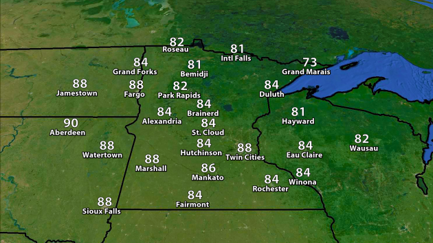
Monday temperatures will be a few degrees warmer versus Sunday across the Twin Cities, reaching the upper 80s.
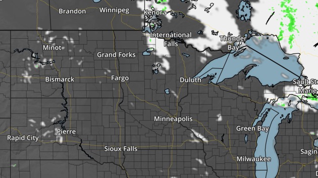
NAM 4km forecast precipitation and cloud cover for 1 PM Monday.
Another
nice day is expected across the state of Minnesota Monday with mainly
sunny skies. A few showers and thunderstorms will be possible across
northern Minnesota Monday night.
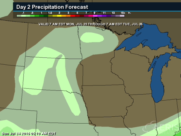
Rainfall with those storms across northern Minnesota is expected to be less than a half an inch Monday night.
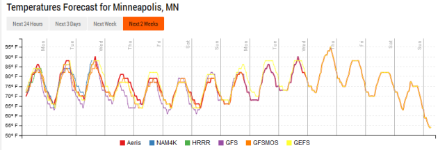
Looking
at the temperature trend, we continue to see that little cool down late
this week across the Twin Cities, but the potential looms for another
warm up next week.
________________________________________________
Monday National Forecast Outlook
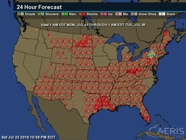
Scattered
storms will be possible across a good portion of the nation Monday. The
strongest are expected to be from the Northeast into the Ohio Valley,
and in parts of the northern/central Plains. In those areas, storms
could be capable of hail and wind.
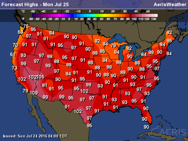
Highs
Monday will continue to climb across parts of the nation, with some
areas of the Northeast potentially approaching records. The record in
Philadelphia for the 25th is 96, and the forecast is calling for a high
around 98. Highs will also be quite warm out west, with parts of
Washington state reaching the mid 90s. The coolest weather across the
nation will be along the Pacific coast, with highs only in the 60s and
70s.
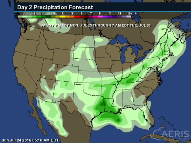
Rain
will be heaviest from the Northeast, through the Ohio Valley and into
the south. Rainfall totals in these areas could be on the order of at
least 1 inch in spots.
Washington D.C. 100 Degree Days
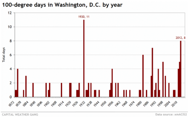
While
100 degrees has been hit before in Washington, D.C., it is actually not
all that common. In fact, the last 100 degree day was back in 2012. Here's more from the Capital Weather Gang: "It’s
been a while since Washington last hit 100 degrees. After amassing an
incredible 17 days with high temperatures of at least 100 from 2010 to
2012, the city has witnessed zero since. Hitting 100 degrees in
Washington is less common than you might think. That sweltering
three-year stretch (from 2010 to 2012) was basically unheard of in the
record prior. We often go a few years between 100-degree readings."
________________________________________________
Thanks for checking in and have a great Monday! Don't forget you can follow me on Twitter (@dkayserwx) or on Facebook (Meteorologist D.J. Kayser)!-D.J. Kayser

No comments:
Post a Comment