Reports of Tornadoes and Damaging Winds Tuesday
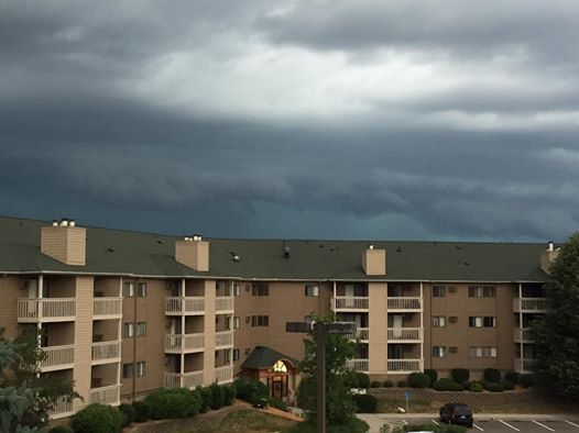
Shelf cloud on the leading edge of the storms Tuesday evening. Image: Nikky Lehtola
Severe
storms swept through the metro (as well as other parts of central and
southern Minnesota) late Tuesday afternoon into the evening, leaving a
swath of damage with them. Above was what was seen as the storms came in
- a shelf cloud. Thanks to my friend (and fellow meteorologist) Nikky
Lehtola for the photo. Numerous trees were reported down across the
region and thousands were without power. There was even flash flooding
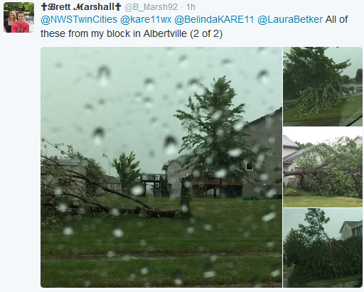
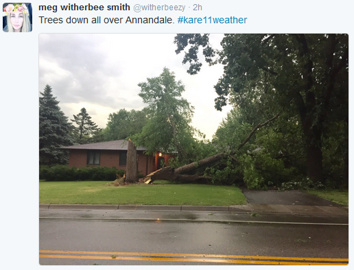
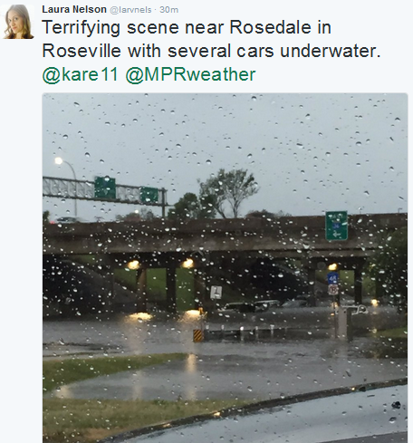
within the Twin Cities metro. Here are some screenshots of photos posted
on social media of damage:
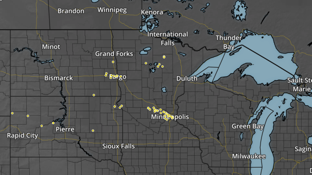
Wind gust/damage reports over the past 24 hours ending 7:20 pm July 5th. Note: reports near Fargo are from Monday evening.
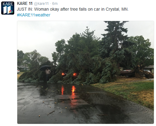
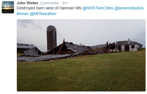
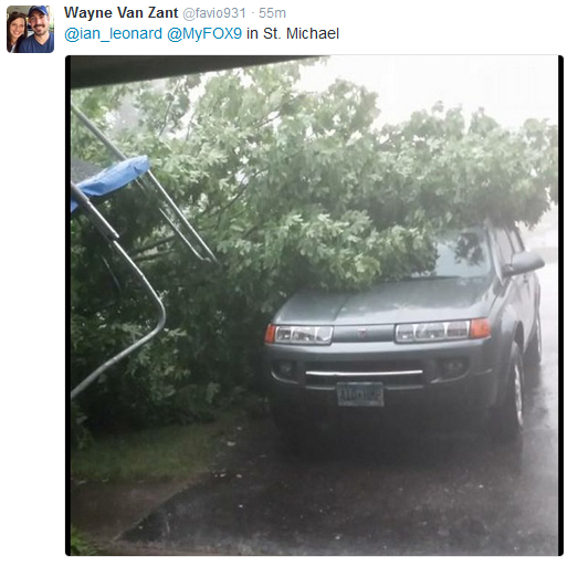
As
you can see from the photos above, there were numerous downed trees due
to the strong winds that came through with the storms, as well as some
building destroyed and siding removed off houses. Here were some of the
peak wind gusts that had come in as of 7:30 PM:
- 3 SSW South Haven - 71 mph
- Kimball - 70 mph
- 1 E Zemple - 70 mph
- 1 N Paynesville - 69 mph
- 2 ESE St. Paul - 67 mph
- 1 WNW Maple Grove - 64 mph
- 1 S Eden Prairie - 61 mph
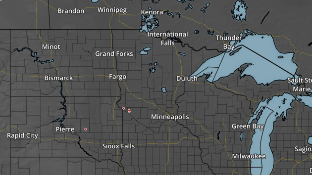
Tornado/funnel cloud reports over the past 24 hours ending 7:20 pm July 5th.
There
were also a few reports of funnel clouds and tornadoes, mainly out in
western Minnesota with the handful of tornado warnings that were issued
across the region. There were two reports of a tornado on the ground
north and northeast of Appleton around 3 PM Tuesday.
_______________________________________________
Heavy Rain Tuesday
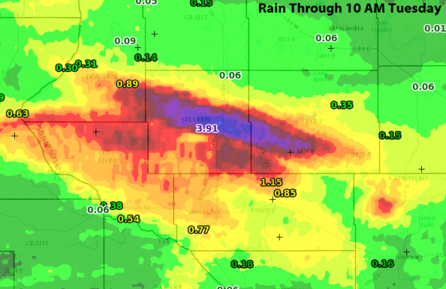
The
other big weather story across Minnesota Tuesday was the heavy rain
that fell in spots. We'll start off in the morning hours, when storms
brought the Morris area between 3-5"+ of rain. Officially at the Morris
airport they picked up 3.91" of rain Monday Night/Tuesday Morning, but
other areas in and around Morris received more:
- Morris 1 SSE: 5.23"
- Morris COOP: 4.51"
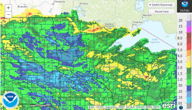
Rain over the past 14 days through Tuesday morning.As you can see, though, many areas of the state need the rain. Most of the Twin Cities has seen less than an inch of rain over the past 14 days, with some of the closest 2" amounts occurring in far southern Minnesota, north of Pine City or out where the rain fell near Morris Monday Night. The only areas that have seen above average rain in the 14 days ending Tuesday morning was out in west-central Minnesota and in far northern Minnesota.
_______________________________________________
Vacation Optional - Fewer Blobs on Doppler Today
By Paul Douglas
Vacation? I don't need no stinking vacation. "Honey, you said the sun would be out by 3 pm. What happened?" Shrug. "Wait, I thought the storms wouldn't arrive until after 7 pm. How did that happen?" my wife demanded. Deep sigh. "You promised a nice lake day! I can't have all these people in my cabin. I'm very disappointed." Stand in line. Hey, I'm OFF. Can't we just be surprised, like everyone else? Meteorologists are on, 24/7 - even when they don't want to be.
Vacation? I don't need no stinking vacation. "Honey, you said the sun would be out by 3 pm. What happened?" Shrug. "Wait, I thought the storms wouldn't arrive until after 7 pm. How did that happen?" my wife demanded. Deep sigh. "You promised a nice lake day! I can't have all these people in my cabin. I'm very disappointed." Stand in line. Hey, I'm OFF. Can't we just be surprised, like everyone else? Meteorologists are on, 24/7 - even when they don't want to be.
Yesterday's
snarling swarm of storms is pushing east. We should salvage a drier,
quieter day today with mid to upper 80s. Typical for early July. The
next wrinkle of low pressure sparks showers and storms Thursday into part of Friday before skies clear in time for another better-than-average weekend.
Expect 70s for highs on Friday and Saturday; 80s make for a better lake-day on Sunday.
Blast-furnace heat passes just south of Minnesota the next couple of
weeks; sizzling near-misses capable of igniting a few more rounds of
storms.
And to my dear wife: feel free to check the new Aeris Pulse app, created just for you!
_______________________________________________
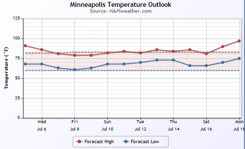
Extended Forecast for Minneapolis
WEDNESDAY: Sunnier and drier. High 87. Low 69. Chance of precipitation 10%. Winds NE 5-10 mph.
THURSDAY: More showers and T-storms. High 83. Low 64. Chance of precipitation 70%. Winds E 8-13 mph.
FRIDAY: Breezy & cooler. Leftover showers. High 76. Low 58. Chance of precipitation 40%. Winds NW 15-25 mph.
SATURDAY: Bright sun, comfortable humidity. High 79. Low 64. Chance of precipitation 0%. Winds E 5-10 mph.
SUNDAY: Sunny and warmer. High 83. Low 70. Chance of precipitation 10%. Winds SE 10-20 mph.
MONDAY: Sticky sun, PM T-storms. High 88. Low 71. Chance of precipitation 50%. Winds S 10-20 mph.
TUESDAY: Few more storms, then slow clearing. High 84. Low 70. Chance of precipitation 40%. Wind SW 5-10 mph.
_______________________________________________
This Day in Weather History
July 6th
Wednesday And Beyond Minnesota Weather Outlook
July 6th
1936: A high of 104 degrees is recorded at Minneapolis.
_______________________________________________
Average Temperatures & Precipitation for Minneapolis
July 6th
Average High: 84F (Record: 104F set in 1936)
Average Low: 64F (Record: 49F set in 19472)
Average Precipitation: 0.12" (Record: 2.83" set in 2015)
________________________________________________
Sunrise/Sunset Times for Minneapolis
July 6th
Sunrise: 5:34 AM
Sunset: 9:02 PM
*Length Of Day: 15 hours, 27 minutes and 46 seconds
*Daylight Lost Since Yesterday: ~1 mins & 5 secs
*Next Sunrise That Is Before 6 AM: August 3rd (6:01 AM)
*Next Sunset That Is Before 9 PM: July 11th (8:59 PM)
________________________________________________
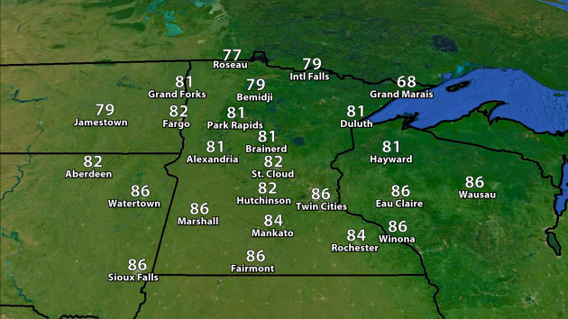
Highs
Wednesday will be a touch cooler across the region, with mid 80s
expected across southern Minnesota during the afternoon hours. Upper 70s
are expected to be found across far northern Minnesota, and with fog
and wind off the lake Grand Marais may not make it out of the 60s.
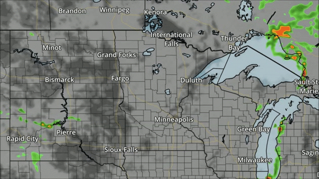
NAM forecast precipitation and clouds every three hours between 7 AM Wednesday and 7 AM Thursday.
We'll
see a mix of clouds and sun across much of the state of Minnesota
Wednesday, with chances of rain increasing Wednesday Night.
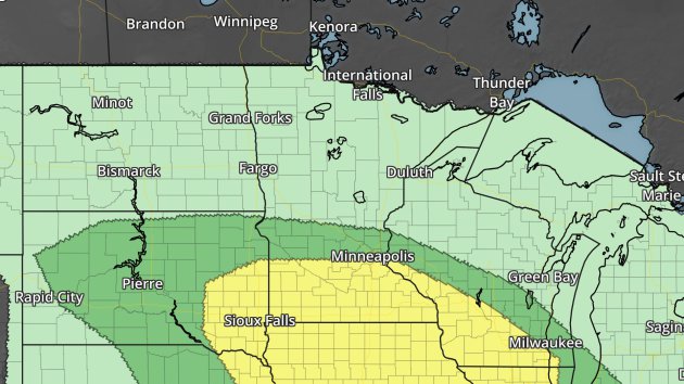
Severe risk Thursday. Dark green - marginal threat. Yellow - slight threat.
Skipping
ahead to Thursday, severe weather will be possible over southern
Minnesota where there is a slight severe risk in effect. Large hail and
damaging winds would be the main concerns.
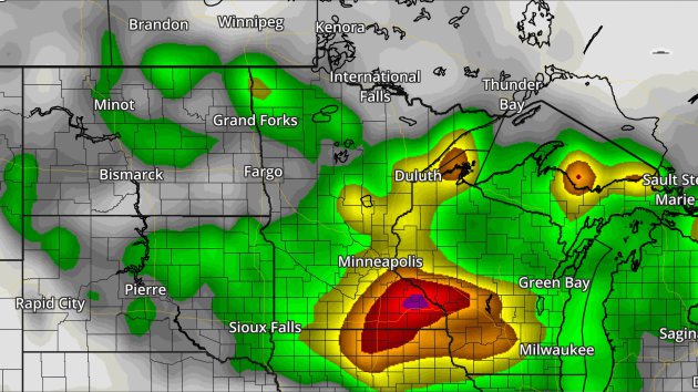
GFS rainfall forecast Tuesday through Saturday morning. Green = 1"+, yellow = 2"+, orange = 3"+, red = 4"+. Image: AerisWeather.
The
storms Thursday will also bring the potential of another 1"+ to the
region. Rainfall totals this week (through Saturday) could total over 3"
in spots of Minnesota and the upper Midwest.
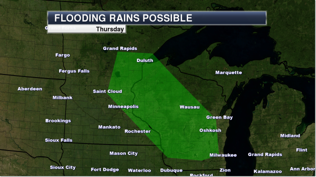
The
Weather Prediction Center has highlighted an area across central
Minnesota (including the Twin Cities) Thursday where rainfall amounts
could exceed flash flood guidance with the incoming storms.
________________________________________________
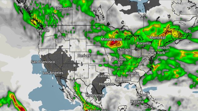
National Forecast Outlook And Stories
NAM forecast precipitation and clouds every three hours between 7 AM Wednesday and 7 AM Thursday.
Some
strong to severe storms are possible Wednesday across the Ohio Valley
with a line of storms expected to form. Elsewhere, we'll be watching
showers and storms across the northern Rockies into the North Central
United States. A cool front will be working into the Northwest late
Wednesday Night, bringing the chance of showers to places like Seattle
by Thursday.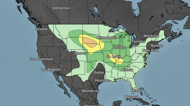
Severe risk Wednesday. Dark green - marginal threat. Yellow - slight threat. Orange - enhanced threat.
Large hail, damaging winds and a few tornadoes are possible Wednesday afternoon and evening across parts of southern/western South Dakota and northern Nebraska. Storms will be most likely after 4 PM MT in these regions and could pack a punch like the storms did in our region Tuesday.
GFS rainfall forecast through Sunday morning. Green = 1"+, yellow = 2"+, orange = 3"+, red = 4"+. Image: AerisWeather.
The
heaviest rain from Tuesday through Sunday morning across the nation
will be across parts of the North Central, Northeast and Ohio/Tennessee
River Valleys, with at least 1-2" of rain expected in many of these
areas.
Iowa Rainfall
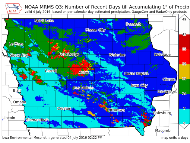
Image: Iowa Environmental Mesonet.Taking a look at our friends to the south, in parts of the state the lack of rain is becoming an issue. In some areas, it's taken a whole month to accumulate an inch of rain, particularly northwest of the Ames area. More from the Iowa Environmental Mesonet: "Rainfall has been difficult to come by for parts of Iowa this summer. The featured map displays the number of days prior to Monday before an inch of precipitation is accumulated. This is computed for each pixel within the NOAA MRMS Q3 precipitation product. This map nicely highlights the very dry conditions that have persisted especially to the north and west of Ames. The orange color represents four to five weeks of time over which only an inch has accumulated. There is some hope for heavy rainfall this week, but the heat will be back in a big way as well."
Beautiful Thunderstorm Picture

________________________________________________
Thanks for checking in and have a great Wednesday! Don't forget you can follow me on Twitter (@dkayserwx) or on Facebook (Meteorologist D.J. Kayser)!-D.J. Kayser

No comments:
Post a Comment