78 F. average high on August 29.
74 F. high on August 29, 2015.
August 30, 1977: Flooding occurs on the southwest side of the Twin Cities, with MSP Airport getting 7.28 inches of rain in 4 1/2 hours.

Slight Cooling - Tropics Heating Up Rapidly
Life is random. So are career choices. If it wasn't for a tropical storm named Agnes in 1972 I might have a real job right now. The storm stalled over my boyhood home in Pennsylvania, flooding our lower level, leaving my mother distraught. It was traumatizing.
Life is random. So are career choices. If it wasn't for a tropical storm named Agnes in 1972 I might have a real job right now. The storm stalled over my boyhood home in Pennsylvania, flooding our lower level, leaving my mother distraught. It was traumatizing.
I
installed a network of river gauges; soliciting volunteers on their CB
radio to report flooding. Then I checked out every book I could find on
storms at the local library. Remember libraries? A tropical storm nudged
me into meteorology. Thanks a lot Agnes.
Tampa
and much of Florida may experience serious flooding this week as a new
tropical storm approaches. Water temperatures in the Gulf of Mexico are
like bathwater: close to 90F. The deeper and warmer the water, the
greater the potential for rapid strengthening.
Our
weather looks benign with a slight cooling trend this week; back down
to average. The sun should be out as we enjoy a welcome dry spell today
into Saturday, before showers and storms return next Sunday.
Many meteorologists can trace their careers back to a specific storm. It beats working for a living.
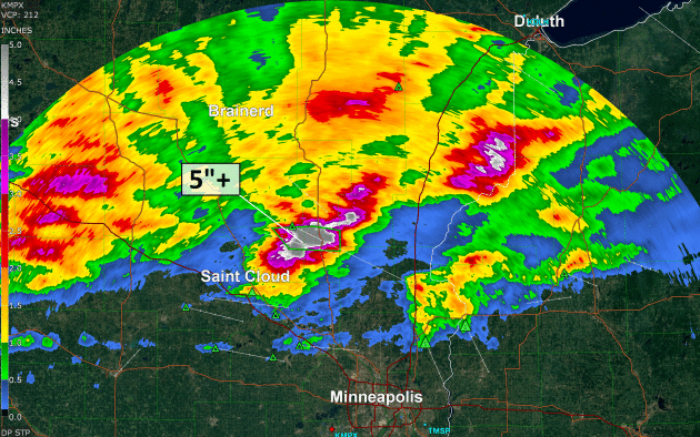
Flash Flooding Overnight.
NOAA Doppler radar rainfall estimates topped 5" from northeast of St.
Cloud to the Mille Lacs area; that's about 6 weeks worth of rain falling
in under 4-5 hours. Much of central and northern Minnesota received
1-2" rains from Monday's cool frontal passage.
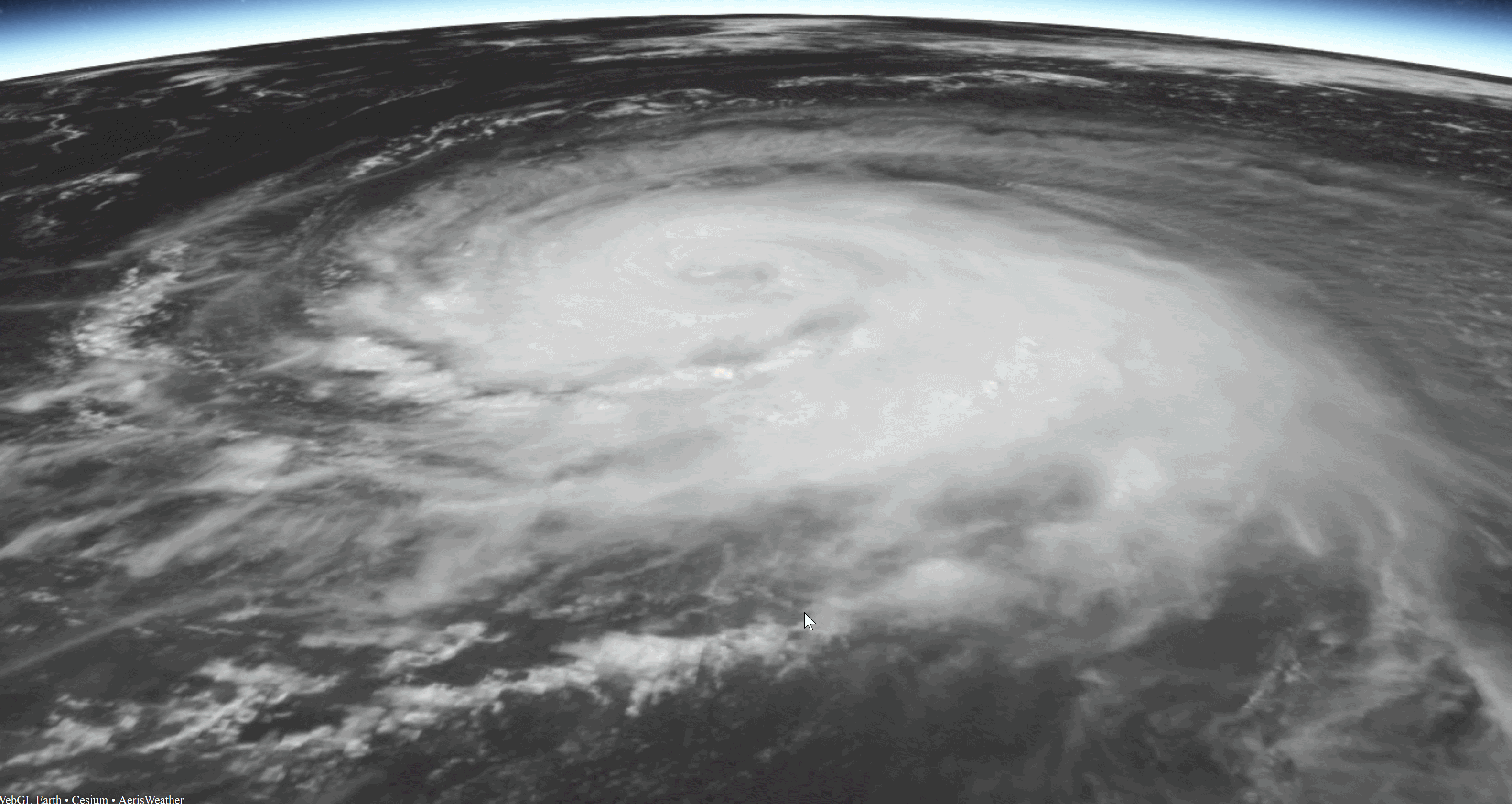
Gaston.
Hurricane Gaston was packing 105 mph sustained winds when this
(visible) image was taken late this afternoon. Gaston is in the
mid-Atlantic and not a risk to Bermuda or the USA. Imagery: NOAA, with a
3-D overlay provided by Aeris AMP.
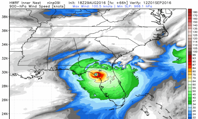
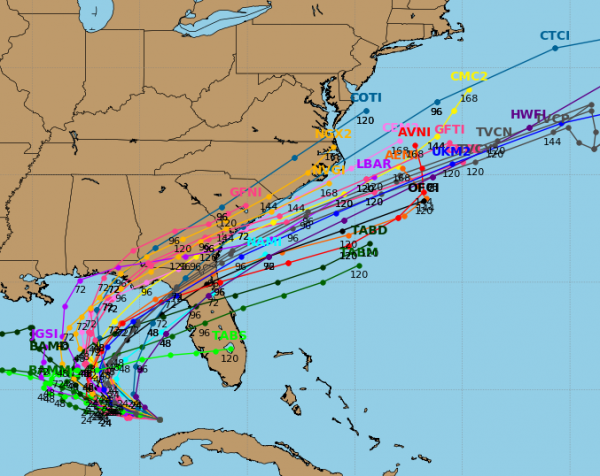
Best Case Scenario for Florida?
Models are now fairly consistent pulling a strong tropical storm or
weak Category 1 hurricane into the Big Bend region of Florida, with the
eye coming ashore well north of Tampa over lightly populated territory.
There may still be a significant storm surge, especially if it coincides
with high tide, but with any luck Tampa will be spared widespread and
major flooding. HWRF model output: NOAA and WeatherBell.
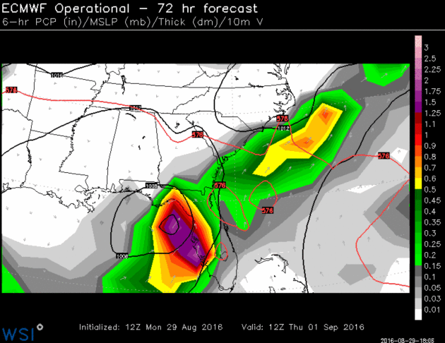
European Model.
We're always happy when NOAA models agree with the ECMWF, the fabled
"Euro", and that seems to be the case now. European guidance pulls a
tropical storm into the Big Bend region of Florida by Thursday morning.
Much of Florida, especially the Gulf Coast and Panhandle, will pick up
5-10" rainfall amounts, with as much as 15" possible in some towns.

* We continue to watch two tropical depressions this morning that look to impact parts of the U.S. over the next few days.
* Tropical Depression Eight, off the Carolina coast, will make a quick approach to the Carolinas later this week before being pushing back out into the Atlantic by a cold front. A Tropical Storm Watch has been issued from Cape Lookout to Oregon Inlet, NC.
* Tropical Depression Nine, in the Gulf of Mexico, will attempt to strengthen into a tropical storm over the next 24-48 hours, eventually swinging to the northeast and making a likely landfall in Florida.
* We are also keeping an eye on Hurricanes Lester and Madeline in the Pacific as they could impact the Hawaiian Islands late this week.

Image credit: Aeris AMP.

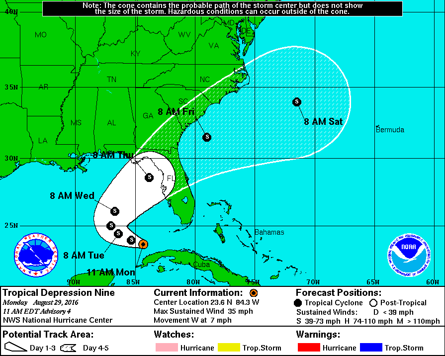


Summary: We continue to watch two systems in the Atlantic that could have an impact on the mainland of the U.S. as we head into the middle of this week. The first, Tropical Depression Eight, looks to brush the Outer Banks with strong winds and higher surf before being pushed back into the Atlantic. The second, and of greater concern, is Tropical Depression Nine, which could make landfall Thursday in Florida as a Tropical Storm. We will also be keeping an eye on two hurricanes – Madeline and Lester – that could approach Hawaii late this week.
Meteorologist D.J. Kayser, AerisWeather
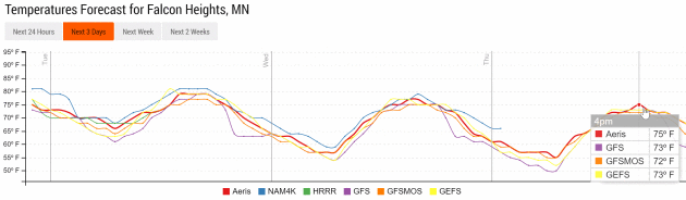
Cooling Trend.
After a hot and steamy Monday north winds begin to cool us back down in
the coming days. Expect mid-70s with sunshine and low humidity if
you're heading to the State Fair Wednesday and Thursday. Temperature
trend: Aeris Enterprise.
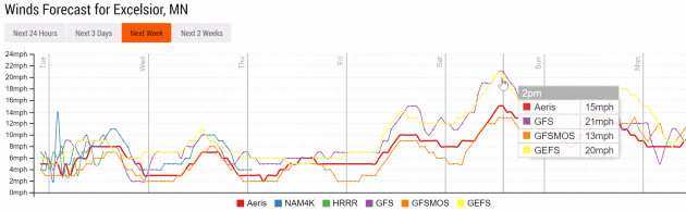
Light Winds Until Saturday.
Expect a welcome spell of dry weather from today into Saturday with
generally light winds the next 4 days. A tightening pressure gradient
may whip up sustained winds over 20 mph by Saturday and Sunday.
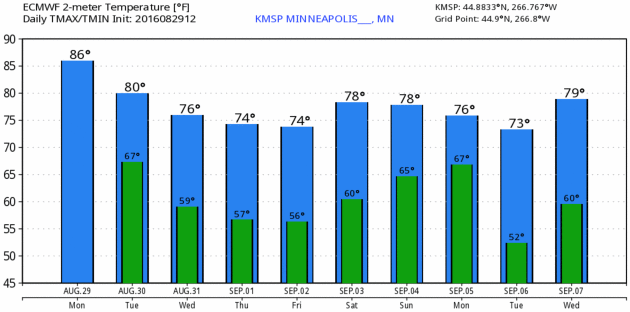
Nice To Be Average.
That's my motto and I use it proudly. Temperatures will actually run a
few degrees below average by midweek before rebounding close to 80F next
weekend. You didn't really think we'd have a hot, dry, sunny Labor Day
weekend, did you? MSP Meteogram: ECMWF and WeatherBell.
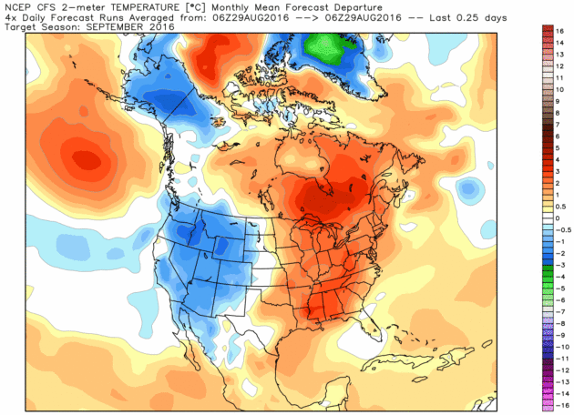
September Outlook.
I know, a forecast of "warmer than average" is truly shocking. How many
months have we been warmer than normal, worldwide? Something like 15
months now. The west is forecast to cool down, but a warm bias is
forecast to linger from Minnesota to the East Coast. NOAA CFSv2 (Climate
Forecast System) outlook courtesy of WeatherBell.

Historic August Flood Caused by "Seemingly Innocuous" Disturbance, Louisiana's Climatologist Says. Here's an excerpt of a story at Baton Rouge Business Report that caught my eye: "...To be classified as a 1,000-year flood event, 21.3 inches of rainfall is required, Keim says. Some areas in the Baton Rouge area far exceeded that. Watson received a whopping 31.39 inches of rain. The Brownfields area saw 26.8 inches, and Denham Springs had 25.5 inches. Keim says nine recording stations exceeded the 1,000-year flood mark. It was the heaviest rainfall on record in the history of Louisiana. “Not only did we beat the record—we crushed it,” Keim says. A flood of this magnitude originating from a small tropical wave is very unusual, Keim says, but the high moisture in the atmosphere from the Gulf of Mexico and the high humidity enabled the system. It was able to take the moisture in the atmosphere and bring it to the ground, he says..."
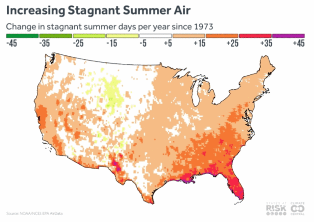
Map credit: "Projections of stagnant air days under continued heat-trapping gas emissions and warming show future increases in the number of these days in both the growing western U.S. and the highly populated eastern areas. As global temperatures warm, the difference between temperatures at the poles and the equator are decreasing, and this is projected to influence the jet stream, bringing an overall decrease in storm tracks through the midlatitudes (including areas over the continental U.S.) and decreasing windiness. The result could be longer spans of stagnant air hanging over U.S. regions."

Counties With Pro-Nuclear Agenda Making Slower Progress on Climate Change. Clean Technica explains: "...The
new study, published in the journal Climate Policy and authored by
researchers at the University of Sussex and the Vienna School of
International Studies, showed that progress towards reducing carbon
emissions and increasing renewable energy sources has been higher in
countries without nuclear energy or in countries with plans to reduce
their existing nuclear capacity. On the flip-side, countries with
nuclear energy or those intending to hold onto their nuclear capacity
are making slower progress, and have been lagging behind in implementing
wind, solar, and hydropower technologies for the purpose of reducing
carbon emissions. The authors of the study note that “it’s difficult to
show a causal link” between the two factors, but nevertheless “the study
casts significant doubts on nuclear energy as the answer to combating
climate change...”

Iowa Utilities Board Approves Huge Wind Energy Project. Some staggering statistics and projects for renewables south of the border, courtesy of AP and KCRG.com: "The Iowa Utilities Board has approved a wind turbine operation it says will be the nation's largest wind energy project. Des Moines-based MidAmerican Energy is behind the planned $3.6 billion wind turbine operation that will generate up to 2,000 megawatts of electricity. MidAmerican Energy said that is enough 800,000 homes and the project will see 85 percent of the company's Iowa customer needs met through wind energy by 2020..."
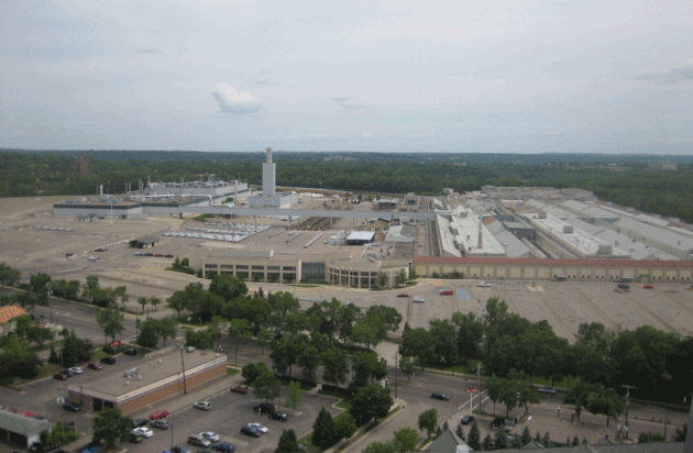
Photo credit: "The site of this former Ford assembly plant, now demolished, is among three locations around the Twin Cities being eyed for net zero (or close to it) development."


TODAY: Damp start, then clearing skies, cooler, drier breeze by afternoon. Winds: N 8-13. High: 80
TUESDAY NIGHT: Partly cloudy, more comfortable. Low: 59
WEDNESDAY: Plenty of sunshine, quite comfortable. Winds: N 5-10. High: 78
THURSDAY: Blue sky, not complaining one bit. Winds: E 5-10. Wake-up: 56. High: 76
FRIDAY: Sunny and milder. A lake-worthy day. Winds: S 10-15. Wake-up: 58. High: 79
SATURDAY: Sunshine much of the day, lukewarm. Winds: S 10-20. Wake-up: 61. High: near 80
SUNDAY: Sticky, few showers and T-storms. Winds: S 10-20. Wake-up: 63. High: 82
LABOR DAY: Stormy start, then slow clearing. Winds: NW 10-15. Wake-up: 64. High: 80
Climate Stories...


Grasping Climate Change. Phil Plait explains why it's so hard for our brains to grasp at Slate: "And that is the true evil of climate change. It’s slow, and patient. It’s everywhere, but takes its time. It operates every day, but its effects don’t manifest for decades. Weather changes every day, every hour, and that noise washes out the signal of climate change. Unless, that is, we too are patient, and keep our eyes on the long view. When we do, we see the trend, not the bumps and wiggles. This short, one-minute video frames it the best way I have ever seen: as a person walking a dog: If we watch the trend, and not the wiggles, we see the impact of humanity on our planet. The temperature trend is actually quite clear now. And that trend is up..." (File photo: Santiago Borja).

File photo: Nati Harnik, Associated Press.
No comments:
Post a Comment