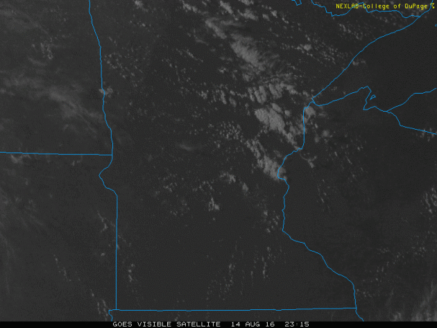
Monday Clouds...
Monday started off on a sunny note, but quickly clouded over as a blob of clouds pushed into the region. This is a view of the cloud mass that worked into the state early Monday. Some spots even saw a little rain as this feature moved in.
More Sticky Air & Storms, Then a Cool Breeze
Buzzzz - By now, the call of late summer cicadas are in full swing, have you heard them? Old adage states that when you hear the first cicada, there is only 6 weeks until frost! Keep in mind that the average first frost date (32 degrees) in the Twin Cities is on October 8th. I actually heard my first cicada of the season this weekend. So, if the old lore is true, we may see a light frost in the northern burbs the last week of September. What could go wrong?
In the meantime, this week will feature another surge of warm and muggy air with highs in the mid to upper 80s and dew points in the mid to upper 60s. Scattered showers and storms break out Tuesday and once again later this week, some of which could be a little on the strong side with locally heavy downpours.
Post front Friday, we'll get our first taste of early fall weather as highs dip into the 70s this weekend and into early next week. I could even see a few locations up north dipping into the 30s for overnight lows!
MN State Fair countdown is on. Only 9 days left!
_______________________________
Extended Forecast
MONDAY NIGHT: Clouds increase, T-shower late. Low: 65. Winds: SSE 5mph.
TUESDAY: Sticky again, few T-storms likely. Winds: SSW 5-10. High: 82
TUESDAY NIGHT: Showers and storms early, then clouds. Winds: SSW 5. Low: 66
WEDNESDAY: Lingering AM puddle. Bright PM Sun. Winds: NW 5. High: 85
THURSDAY: Warm & muggy, thunder overnight. Winds: SSE 5-10. Wake-up: 67. High: near 90
FRIDAY: T-showers with locally heavy rain. Winds: WNW 10-15. Wake-up: 68. High: 82
SATURDAY: Cooler breezy, afternoon rumble?. Winds: N 5-10. Wake-up: 60. High: 73
SUNDAY: More sun. Refreshing. Winds: W 5. Wake-up: 55. High: 74
MONDAY: Isolated afternoon T-shower. Winds: SSW 10-15. Wake-up: 56. High: 74.
__________________________________
__________________________________
This Day in Weather History
August 16th
August 16th
1981: Chilly temperatures are felt across Minnesota. Tower reports a low of 33 degrees.
___________________________________
___________________________________
Average High/Low for Minneapolis
August 16th
August 16th
Average High: 81F (Record: 99F set in 1988)
Average Low: 62F (Record: 47F set in 1962)
____________________________________
Average Low: 62F (Record: 47F set in 1962)
____________________________________
Sunrise/Sunset Times for Minneapolis
August 16th
August 16th
Sunrise: 6:17am
Sunset: 8:16pm
Sunset: 8:16pm
*Daylight Lost Since Yesterday: ~2mins & 47secs
*Daylight Lost Since Summer Solstice (June 20th): ~1hour & 36mins
____________________________________
*Daylight Lost Since Summer Solstice (June 20th): ~1hour & 36mins
____________________________________
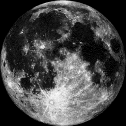
Moon Phase for August 16th at Midnight
1.1 Days Until Full Sturgeon Moon
1.1 Days Until Full Sturgeon Moon
"Aug. 18, 4:27 a.m. CDT — The Full Sturgeon Moon, when that large fish of the Great Lakes and other major bodies of water like Lake Champlain is most readily caught. A few tribes knew it as the Full Red Moon because the moon rises looking reddish through sultry haze, or as the Green Corn Moon orGrain Moon."
________________________________________
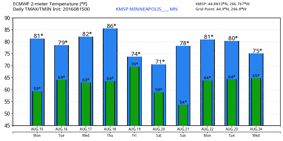
Extended Outlook
Here's the extended outlook through the middle part of next week. Note that temps look to warm a little through the week ahead back to above average levels before a fairly stout cold front plows in late this week/weekend. Temperatures look to quickly dip to below average levels for a few days with highs in the 70s and low in the 50s. There may even be a few spots in northern Minnesota that see overnight lows in the 30s!
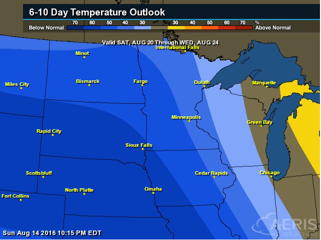
6 to 10 Day Temperature Outlook
According to NOAA's CPC, the 6 to 10 day temperature outlook suggests cooler than average temperatures settling in across much of the Midwest and Central U.S. from August 20th to 24th. This will be our first real bout of cooler temps, which may even be a little reminiscent of early fall-like weather!
___________________________________
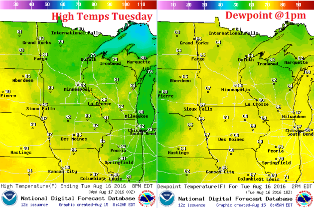
Tuesday Weather Outlook
High temperatures on Tuesday will be near average across the state, but it'll feel a little bit more sticky with dew points a little higher than they've been over the past few days.
Tuesday Weather Outlook
Winds will also not be an issue, but a light southerly breeze will help to continue ushering in warm and slightly more muggy air, which will peak later this week.
Tuesday Weather Outlook
As an impulse of energy works through the Upper Midwest, scattered showers and storms will push through. Some of the storms could be a little on the strong side with locally heavy downpours possible as well.
________________________________
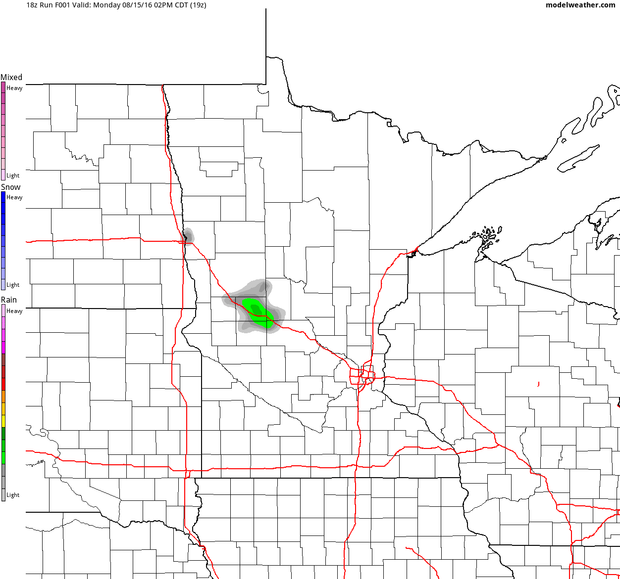
Simulated Radar
The simulated radar through Wednesday night, which shows scattered showers and storms working through the region through PM Tuesday. Some of the storms could be a little on the strong side Tuesday afternoon with locally heavy downpours.
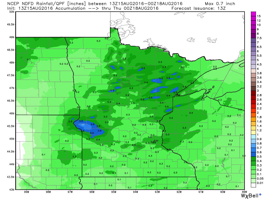
Rainfall Potential
The rainfall potential through PM Wednesday suggests pockets of heavier as scattered showers and storms develop. Not everyone will see rainfall, but some could see locally heavy amounts where the storms develop.
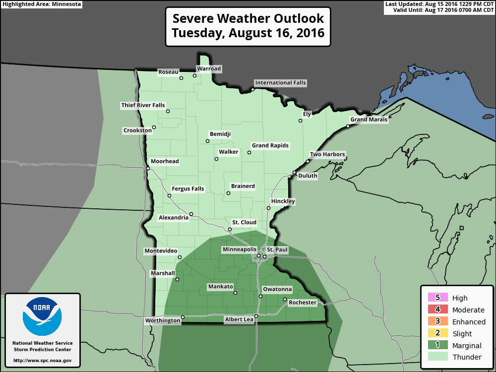
Severe Threat Tuesday
...UPPER MS VALLEY... MODERATE INSTABILITY IS EXPECTED IN THIS REGION DOWNSTREAM FROM A LOW-AMPLITUDE SHORTWAVE TROUGH THAT WILL MOVE THROUGH THIS AREA DURING THE AFTERNOON. THIS REGION WILL RESIDE ALONG ERN FRINGE OF STEEPER LAPSE RATE PLUME...BUT ONLY MODEST WINDS ALOFT AND VERTICAL SHEAR WILL ACCOMPANY THE MID-LEVEL WAVE. THUNDERSTORMS ARE EXPECTED TO REDEVELOP AS THE BOUNDARY LAYER DESTABILIZES. VERTICAL SHEAR FROM 25-30 KT AND MLCAPE GENERALLY AROUND 2000 J/KG WILL SUPPORT POTENTIAL FOR A FEW MULTICELL STORMS TO PRODUCE LARGE HAIL AND ISOLATED DOWNBURST WINDS FROM MID AFTERNOON THROUGH EARLY EVENING.
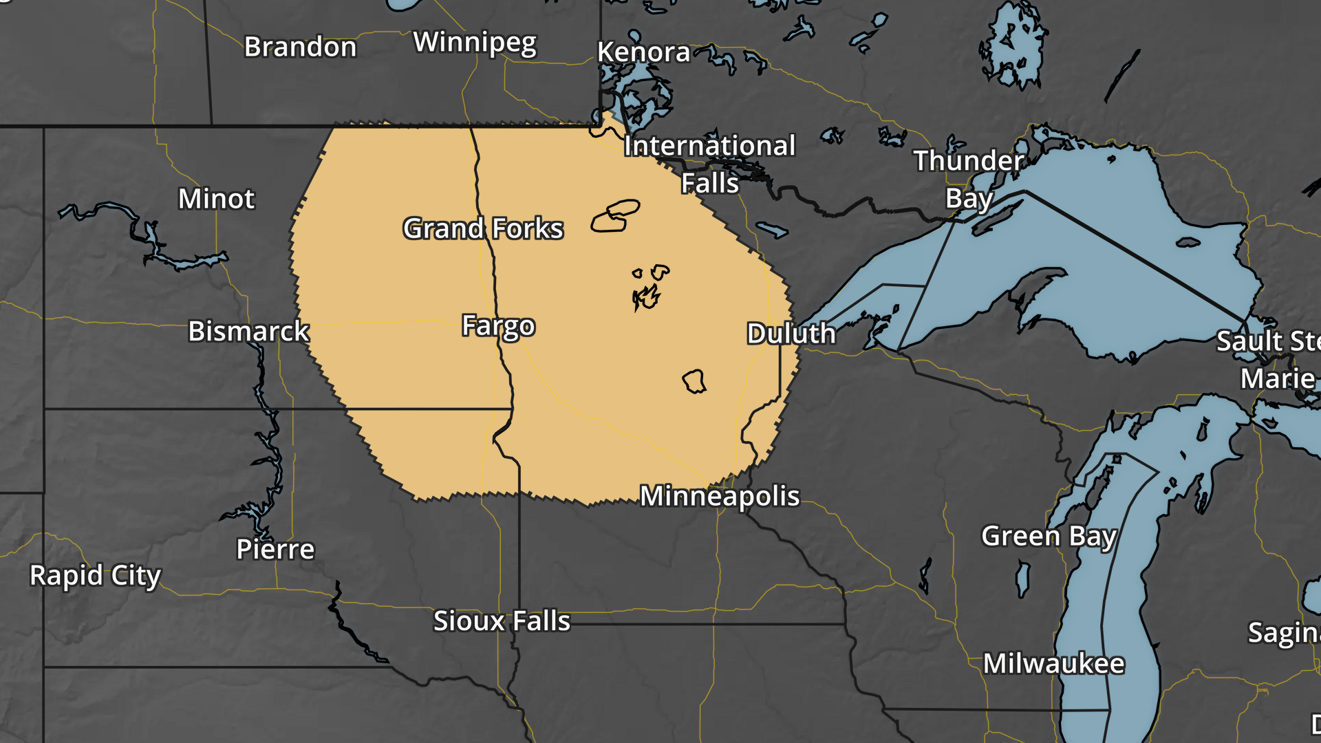
Severe Threat Thursday
THE 00Z ECMWF/GFS ARE IN GENERAL AGREEMENT WITH A LARGE-SCALE TROUGH DEVELOPING ACROSS WESTERN CANADA ON DAY 3/WED AND ARE IN SOMEWHAT BETTER AGREEMENT WITH THIS TROUGH AS IT ADVANCES INTO THE NORTHERN HIGH PLAINS...DAKOTAS/MN TO UPPER GREAT LAKES REGION ON DAY 4/THU. EACH MODEL CONTINUES TO SUGGEST ONE OR TWO WEAK MIDLEVEL IMPULSES WILL TRACK EAST ACROSS THE DAKOTAS WITHIN THE WEST-SOUTHWEST FLOW ALONG THE LEADING PERIPHERY OF THE APPROACHING LARGE-SCALE TROUGH. FORCING FOR ASCENT ATTENDANT TO THESE IMPULSES AND HEIGHT FALLS WITH THE WESTERN CANADA TROUGH SHOULD SUPPORT THUNDERSTORM DEVELOPMENT ACROSS THE NORTH-CENTRAL STATES THURSDAY AFTERNOON AND EVENING. THE STRONGEST STORMS AND POTENTIAL FOR SEVERE STORMS SHOULD BE ACROSS EASTERN ND/NORTHWEST MN...WHERE CAPE/SHEAR PARAMETER SPACE WILL BE MOST FAVORABLE TO SUPPORT A 15-PERCENT SEVERE-WEATHER PROBABILITY AREA. THE POTENTIAL CONTINUES FOR UPSCALE GROWTH THURSDAY NIGHT TO EARLY FRIDAY MORNING ACROSS NORTHERN/CENTRAL MN TOWARD FAR NORTHWEST WI WITHIN INCREASING WAA ALONG A STRENGTHENING SOUTHWESTERLY LLJ INTO THIS REGION. MODERATE ELEVATED INSTABILITY COULD PROVE FAVORABLE FOR AN ISOLATED SEVERE-WEATHER THREAT INTO THE OVERNIGHT.
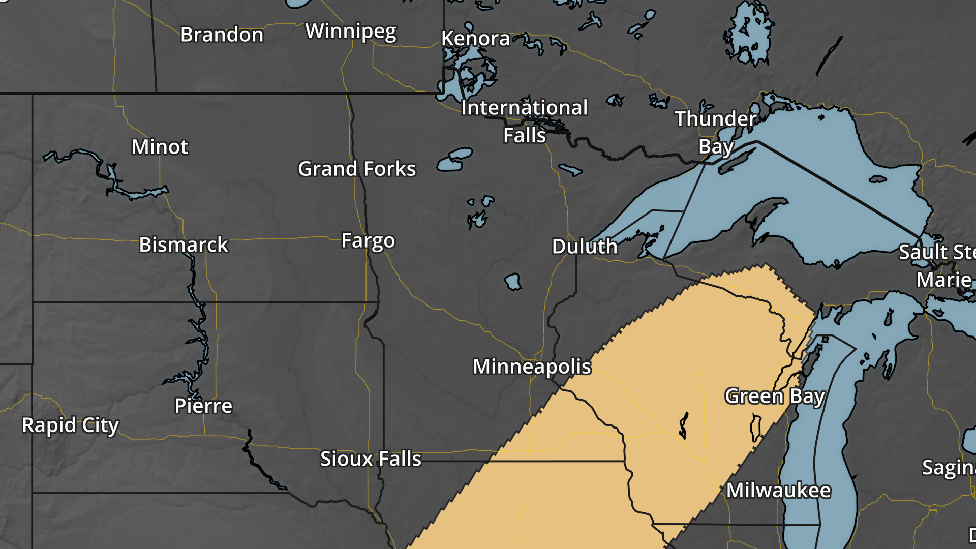
Severe Threat Friday
...DAY 5/FRI... CONSENSUS OF THE 00Z ECMWF/GFS CONTINUES TO SHOW AMPLIFICATION OF THE LARGE-SCALE TROUGH AS IT BECOMES NEUTRALLY ORIENTED ACROSS THE NORTH-CENTRAL STATES INTO THE CENTRAL PLAINS AND MID MS VALLEY ON FRIDAY. MEDIUM RANGE MODELS CONTINUE TO SUGGEST SHOWERS AND STORMS WILL DEVELOP ALONG THE COLD FRONT AS IT ADVANCES THROUGH THE UPPER MS VALLEY AND CENTRAL PLAINS. THIS OUTLOOK IS MAINTAINING A 15-PERCENT SEVERE RISK AREA...THOUGH HAS NARROWED IT SOME BASED ON THE TIMING OF THE COLD FRONT THROUGH THE PEAK HEATING. DESPITE MODEST LAPSE RATES...A VERY MOIST WARM SECTOR WILL CONTRIBUTE TO MODERATE INSTABILITY...THOUGH STRONGER BULK SHEAR MAY TEND TO LAG THE COLD FRONT. HOWEVER...GIVEN THE POTENTIAL FOR SUFFICIENT BULK SHEAR NEAR THE FRONT...A SEVERE WEATHER THREAT REMAINS WARRANTED.
____________________________________
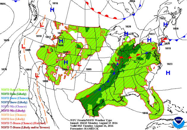
National Weather Outlook
The national weather outlook keeps scattered storms and heavy rain across the Lower Mississippi Valley through parts of Ohio Valley and the Northeast over the next few days. Another, weaker system, will slide across the northern tier of the nation through the early week time frame with a few strong storms and pockets of heavy rainfall.
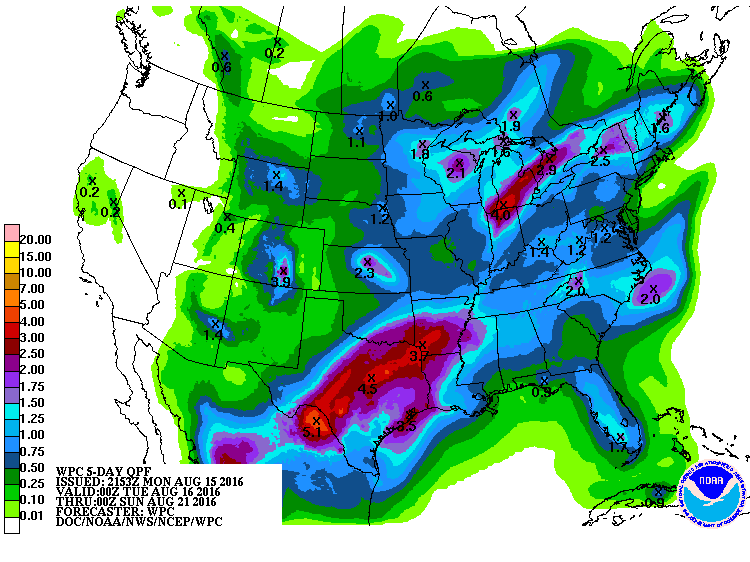
5 Day Precipitation
According to NOAA's WPC, the 5 day precipitation outlook still suggests heavy rainfall across the southern U.S., where some 3" to 4"+ will be possible. There will also be heavy rainfall and flooding potential across the Great Lakes Region. Meanwhile, the Western U.S. looks to stay fairly dry.
____________________________________
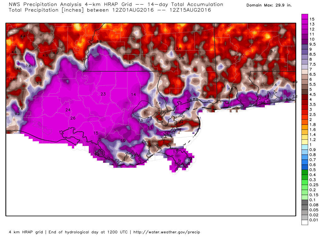
14 Day Rainfall in Louisiana
The radar estimated rainfall over the last 14 days suggests widespread 1ft. to 2ft. rainfall amounts across much of the southern part of the state. Even parts of Mississippi and Alabama have seen some significant amounts.
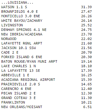
Here's a look at some of the actual amounts reported. Note the 31" amount in Watson, LA!! Many locations have seen double digit tallies since the event began.
________________________________________
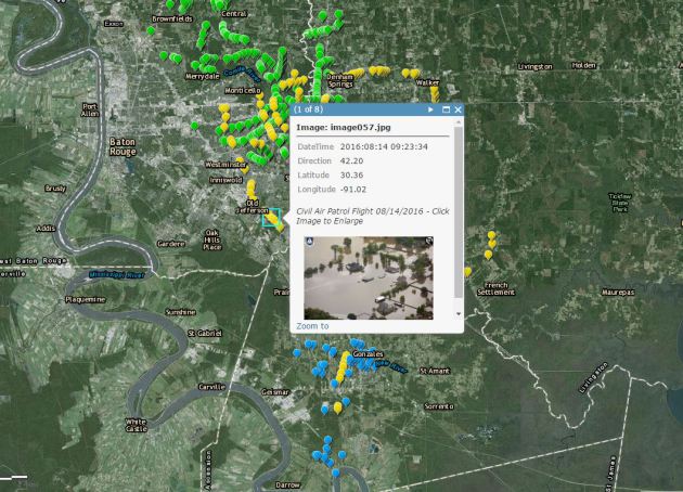
Aerial Flood Pictures from Louisiana
What does the widespread flooding look like from above? Take a look at the interactive map link below from the Civil Air Patrol. These are pretty amazing pictures...
Impact of the Louisiana Flooding
If you haven't seen this incredible video from WAFB, it's worth watching. Unreal honestly...
"BATON ROUGE, LA (WAFB) - A woman survived a near-drowning in Louisiana floodwater thanks to some men on a boat who arrived at the perfect time, and it was captured on a dramatic video. The woman's convertible was about two-thirds submerged and she can be heard asking for help. "Oh my God, I'm drowning," the woman can be heard saying from inside the car. Three men pull up in a boat and try to break a window on the car to free the woman, but they aren't successful. The car keeps sinking and one of the men jumps out of the boat onto the car and starts to tear through the convertible's fabric roof. It's only after the car is fully submerged that the woman is pulled to safety."
"A woman and her dog were pulled to safety just as the car they were in sank. (Source: WAFB)

____________________________________________________
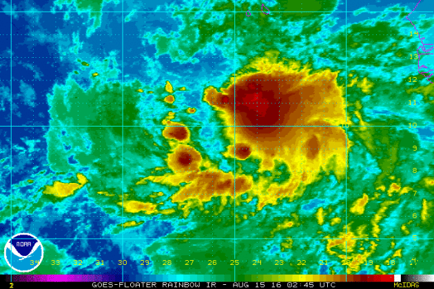
Tropical Update
This is Invest 98L in the Atlantic Basin. NOAA's NHC suggests that this wave off the western tip of Africa has a moderate chance of tropical development within the next 5 days.
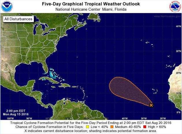
5 Day Tropical Outlook
According to NOAA's HPC, there is a wave off the western tip of Africa that has a moderate chance of tropical development within the next 5 days. The latest forecast suggests that the wave will lift northwest through the central Atlantic basin.
_________________________________________
"How Rio's Climate Will Impact Olympic Running Records"
"World — and Olympic — records have been falling left and right in the Rio de Janeiro Games, and it’s fair to expect that track and field will be a ripe spot for more smashing records. But a surprising number of factors impact a race that have absolutely nothing to do with an athlete’s abilities or training: track surface, running shoes, starting blocks … and weather. Here’s how Rio’s tropical climate will influence the runners, from the 100 meter to the marathon."
Temperature
"Hot weather is a problem for endurance runners. The ideal race temperature will depend on a lot of things, but one analysis of data from nearly two million marathoners pegs it at between about 40 and 50 degrees Fahrenheit. It’s wintertime in Rio right now, so temperatures aren’t expected to be scorching, but it’s still a pretty hot place. The 5:30 a.m. start times for the races (men this Sunday, women next Sunday) will help, but expect temperatures at least in the 70s, which will put a damper on record-shattering hopes. The Olympics so far have also been bright at sunny, which is great for spectators but hard on endurance runners. Sunny hot weather affects performance more than heat on its own. The opposite is true for sprinters. Hot weather actually improves performance, because warm air is lighter and exerts less drag on the runners. Sprinters don’t have to worry about overheating in a 10-second race, but overcoming wind resistance costs 100-meter athletes like Usain Bolt more that 90 percent of total energy expended. A 36-degree rise in temperature relieves air pressure almost as much as gaining 2,000 feet of altitude, and that makes a big difference in a race that’s decided by hundredths of seconds."
"Usain Bolt of Jamaica runs to win the 'Mano a Mano' Men's 100m challenge at Copacabana beach on August 17, 2014 in Rio de Janeiro, Brazil."

_______________________________________
"Climate change could limit sites for Summer Games, study warns"
"The weather’s been pretty warm for the Summer Olympics in Rio de Janeiro, but just wait a few decades — the rising heat and humidity from climate change could put the Games in jeopardy, and San Francisco could become one of the few cities where conditions will be suitable for hosting them, warns a group of physicians led by a UC Berkeley researcher. “The climate could be so bad in 70 years that the Games will change forever,” said Kirk Smith, a professor of public health at UC Berkeley. “They might hold the Summer Games indoors, but can you imagine running an indoor marathon?” Smith led a group of U.S. and New Zealand specialists who published a commentary Friday in the British medical journal the Lancet, warning that the most conservative models of climate change predict that by 2085 only three cities in North America, including San Francisco, will be cool enough to hold the Summer Games. The others are Calgary, Alberta, and Vancouver, British Columbia, the researchers said. The dangers of engaging in endurance sports in hot weather are well known. Smith pointed out that one runner died and 300 were treated for nausea, heart palpitations and other problems during the 2007 Chicago Marathon, when temperatures hit the upper 80s. Ironically, race organizers had hoped that a successful marathon would boost the city’s chances of hosting the 2016 Summer Olympics. Instead, Smith noted, “they had to call off the race,” with thousands of runners still on the course."

_____________________________________
Thanks for checking in and have a great rest of your week! Don't forget to follow me on Twitter @TNelsonWX

No comments:
Post a Comment