Under Water...
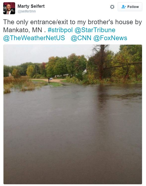
The heavy rain event that unfolded across the southern half of the state earlier this week left many areas under water. Here's a picture from Mankato, MN from @seifertmn.
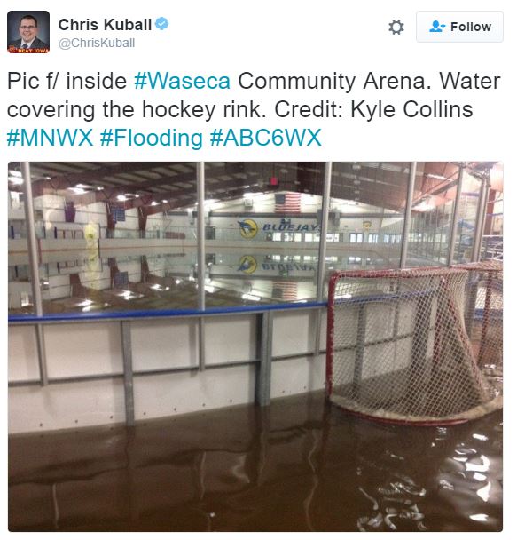
Take a look at this picture from inside the Waseca Community Arena, which shows water covering the hockey rink! Note that there were reports of nearly 10" to 14" of rain around Waseca!
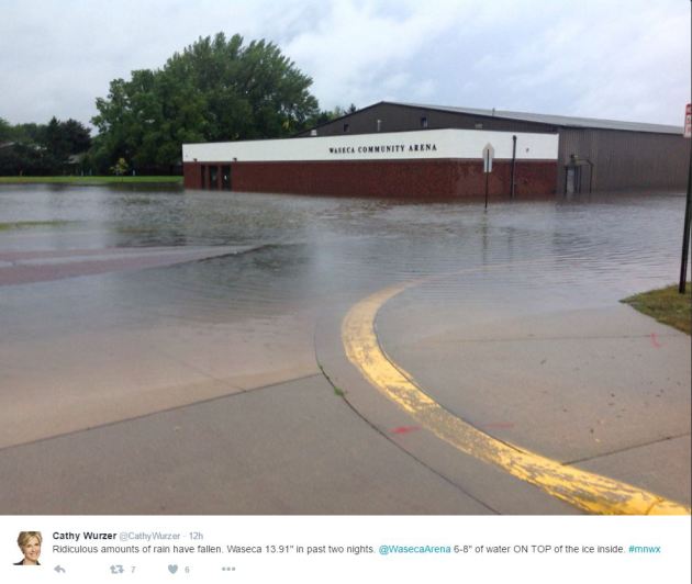
Here's another one from outside the Waseca Community Arena!
Record Flood Stage at the North Fork Zumbro River Near Wanamingo
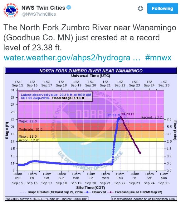
So much rain fell that the Zumbro River near Wanamingo saw a record flood stage at 10am Thursday! Interestingly, note how quickly the river came up! In about 12 hours, the river jumped nearly 12 feet, which is pretty incredible! It also poses major safety concerns as well.
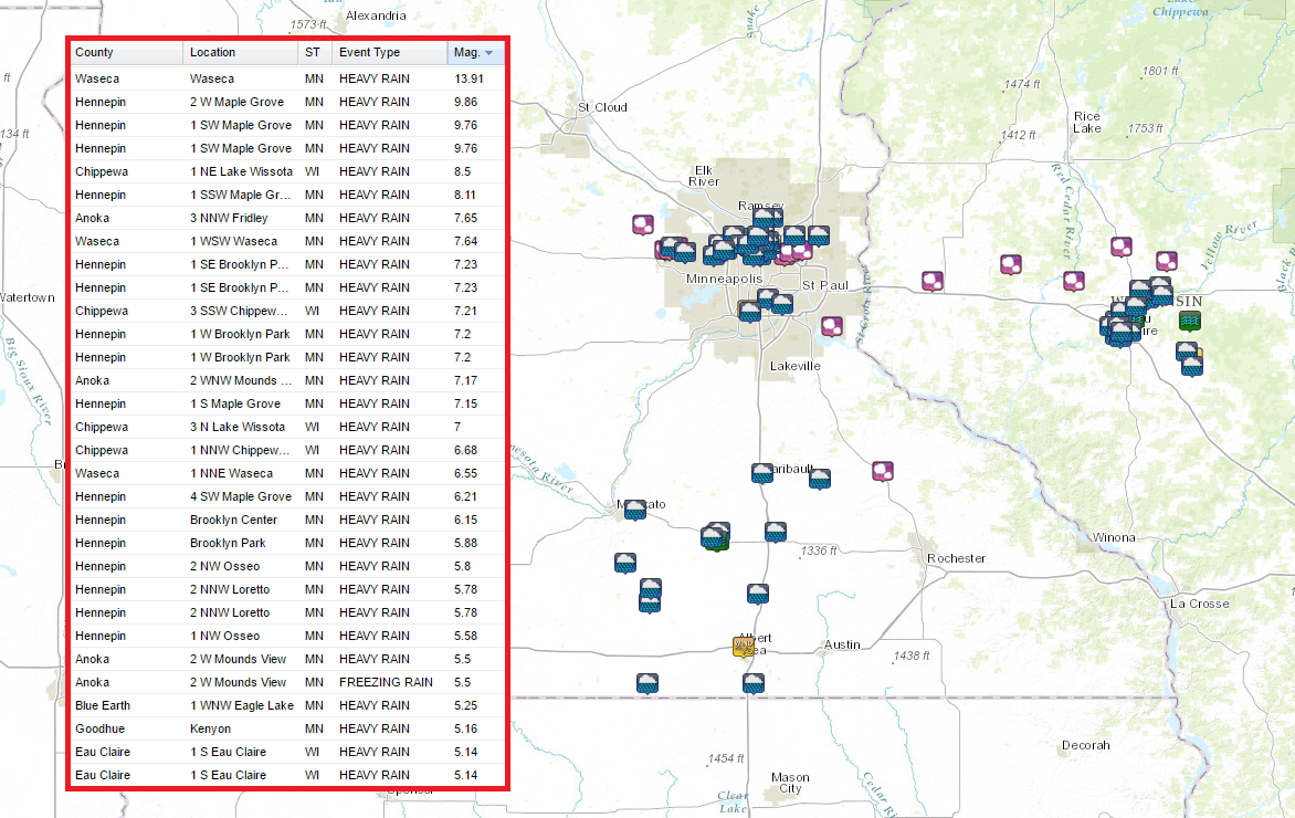
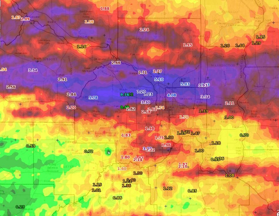
How Much Rain Fell?
Take a look at the impressive rainfall tallies from the event earlier this week. Note the near 14" tally in Waseca and the near 10" tally in Maple Grove!
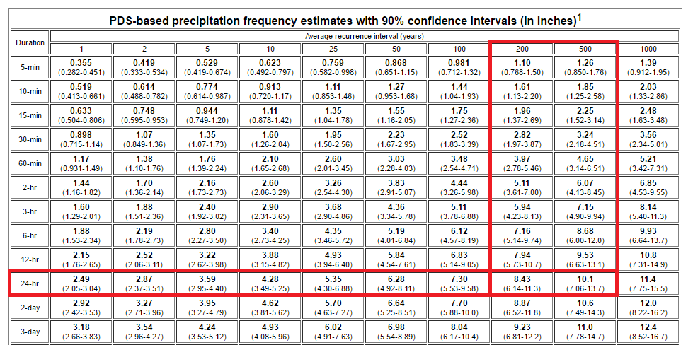
200 to 500 Year Flood?
According to NOAA's ATLAS, the 9.86" of rain that fell in Maple grove within a 24 hour period may be a 200 to near 500 year flood event. Regardless of how many year flood event it is, to see near 10" of rain within that short amount of time, it's pretty impressive!
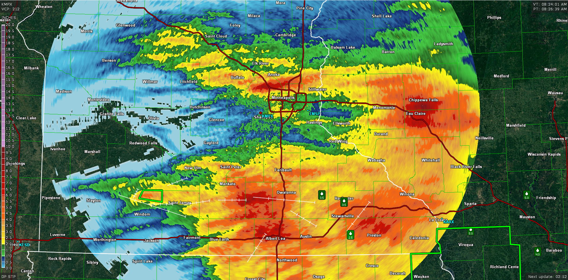
Radar Estimated Rainfall
This is the radar estimated rainfall, which shows the heaviest rainfall across parts of the northern Twin Cities Metro and also across southern Minnesota and western Wisconsin.
A closer view of the Twin Cities shows a fairly large band of 6" to near 10" amounts on the north and northwest side of the Twin Cities. This is where numerous reports of flooded roads, stranded motorists and flooded basements were reported.
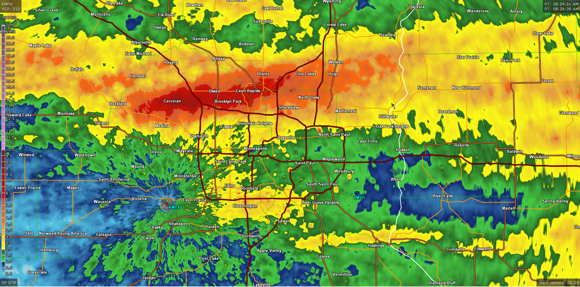
An even closer look across the northern Twin Cities metro shows some or the amounts that fells during the heavy rain earlier this week. Note the 9.76" tally in north-central Hennepin county near the I-94/694 split.
Flooding Rain Event - PM Wednesday
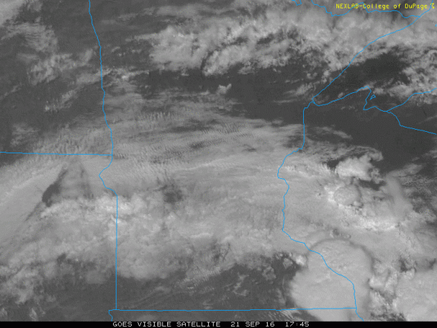
This is what the visible satellite image looked like as the flooding rain event got underway late Wednesday. Note the large clouds blowing up just before sunset over parts of eastern Minnesota and western Wisconsin. This activity continued for much of the night, which helped to promote long duration heavy rain over some of the same areas hour after hour...
Flooding Rain Event
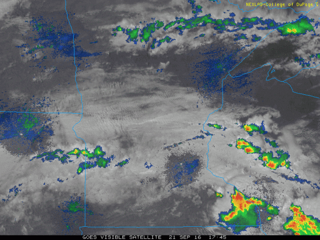
This is the same loop as above, but now shows the composite radar. Note the line of intense thunderstorms that developed on the northern side the Twin Cities metro. This is the band that produced widespread 6" to near 10" amounts in the areas mentioned above!
______________________________________
Fall Color Update
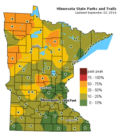
According to the MN DNR, we are well on our way in the fall color department with some 50% to 75% color being reported across parts of Central and Northwestern Minnesota. Keep in mind that the average peak for the Twin Cities is generally late September to mid October.
___________________________________________________
2016 - Wettest start to the year on record
We seem to be able to count on heavy rain this year as much as we can count on a Brian Dozier home run. In other words, it is happening a lot!
A moist wind in the lower part of the atmosphere helped fuel record rainfall earlier this week across the southern half of the state. Reports of flooded streets, basements and even water rescues made headlines as nearly 14 inches of rain fell in Waseca over a 48 hour period. Widespread 6 to nearly 10 inches fall across the northern metro in 12 hours, which according to NOAA's ATLAS, is considered to be between a 200 and 500 year flood event!
The Twin Cities Weather Service reports that Minneapolis has seen 30.81" of rain from January 1st to September 21st, which is the wettest such period on record. Would it surprise you to know that there's more rain on the way for the weekend? Good grief.
There may be a few spotty t-showers later Friday, but there is a much better chance of scattered storms later Saturday. The slow moving storm keeps cool showers in place through early next week.
___________________________________________________
Extended Weather Outlook
THURSDAY NIGHT: Still unsettled, another T-shower. Winds: ENE 5-10. Low: 60
FRIDAY: More showers, possible thunder - cool, damp breeze. Winds: ESE 10-15. High: 66
FRIDAY NIGHT: Slight chance of a shower or storm. Winds: SE 10. Low: 60
SATURDAY: Warm sunshine, T-storms arrive late. Winds: SE 10-20. High: 75
SUNDAY: Breezy with a few spits of PM rain. Winds: WSW 10-20. Wake-up: 58. High: 69
MONDAY: Octoberish. Gray skies and showery. Winds: WSW 7-12. Wake-up: 50. High: 62
TUESDAY: Drab clouds, more showers. Winds: WNW 5-15. Wake-up: 49. High: 62
WEDNESDAY: Lingering AM shower, slow PM clearing. Winds: SW 5-10. Wake-up: 48. High: 65
THURSDAY: Finally some sun. Winds: SSE 5-10. Wake-up: 50. High: 67.
_______________________________
_______________________________
This Day in Weather History
September 23rd
September 23rd
1995: 0.2 inches of snow falls in the St. Cloud area.
1985: Early snow falls over portions of Minnesota and western Wisconsin. Just under a half inch (0.4) is recorded at MSP Airport, mostly during the afternoon.
1937: From summer to winter. The temperature was 101 at Wheaton. Then a cold front came through causing the mercury to tumble below freezing.
________________________________
________________________________
Average High/Low for Minneapolis
September 23rd
September 23rd
Average High: 69F (Record: 90F set in 1937)
Average Low: 49F (Record: 30F set in 1983)
_________________________________
Average Low: 49F (Record: 30F set in 1983)
_________________________________
Sunrise/Sunset Times for Minneapolis
September 23rd
September 23rd
Sunrise: 7:02am
Sunset: 7:07pm
Sunset: 7:07pm
*Daylight Lost Since Yesterday: ~3mins & 6sec
*Daylight Lost Since Summer Solstice: ~3hours and 32mins
__________________________________
*Daylight Lost Since Summer Solstice: ~3hours and 32mins
__________________________________
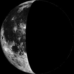
Moon Phase for September 23rd
0.9 Days After Last Quarter
0.9 Days After Last Quarter
___________________________________
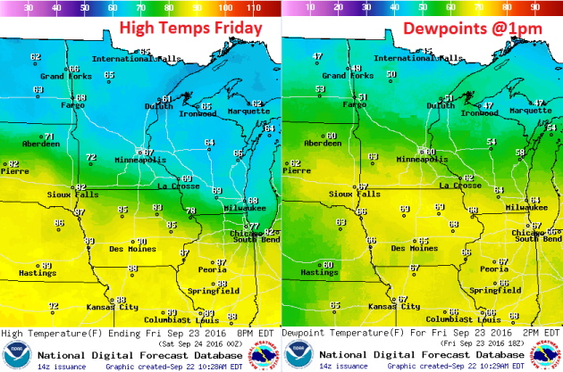
Weather Outlook Friday
The stalled frontal boundary that brought us heavier rain early this week will sag south a bit on Friday allowing cooler temperatures to settle south along with it. Note the widespread 60s for high temperatures across the state with dewpoints still hovering in the somewhat muggier category (60s) across much of southern Minnesota.
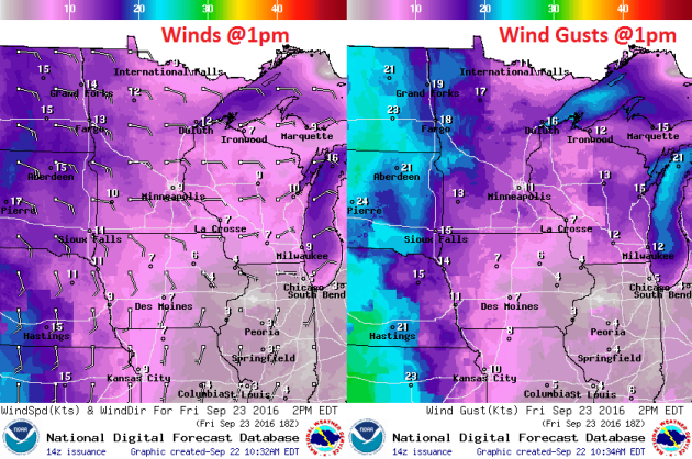
Weather Outlook Friday
Winds will continue to pick up out of the east as an area of low pressure approaches from the west. This storm system will help to tighten up the pressure gradient and allow winds to increase over the next couple/few days.
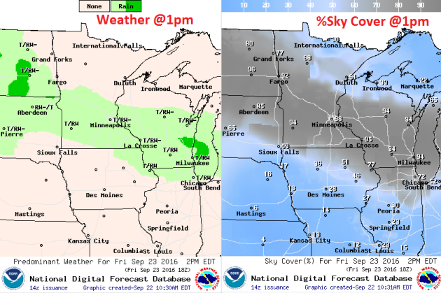
Weather Outlook Friday
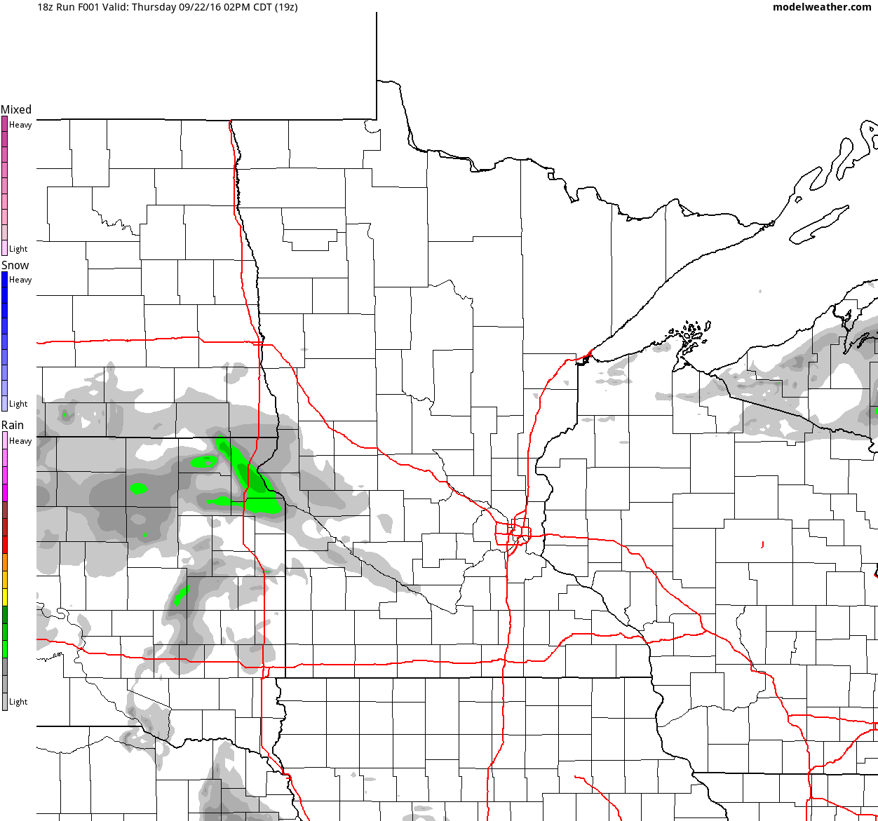
Although Friday doesn't look like a complete washout, there could be some spotty afternoon/evening storms that develop across parts of central and southern Minnesota. This will also keep clouds in place over much of the state with the exception of those in the Arrowhead.
Simulated Radar
The simulated radar from PM Thursday to Sunday suggests unsettled weather continuing across the state as our next storm system approaches from the west. This first chance of spotty storms will be with us on Friday, but the next best chance moves in late Saturday through early AM Sunday.
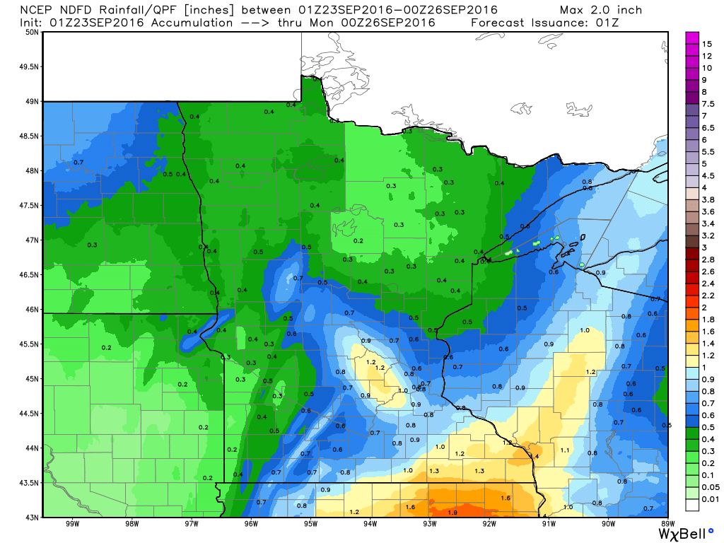
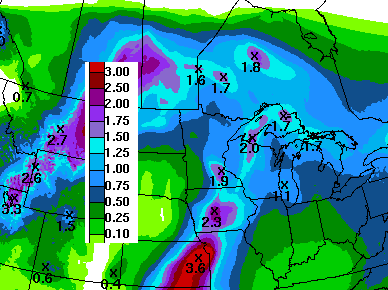
Rainfall Potential
Rainfall potential through PM Sunday suggests another round of potentially heavier rainfall tallies across southern Minnesota and into Wisconsin. The setup this time doesn't look near as heavy as the last round earlier this week, but there still could be some 1"+ amounts across the southeastern part of the state.
__________________________________________
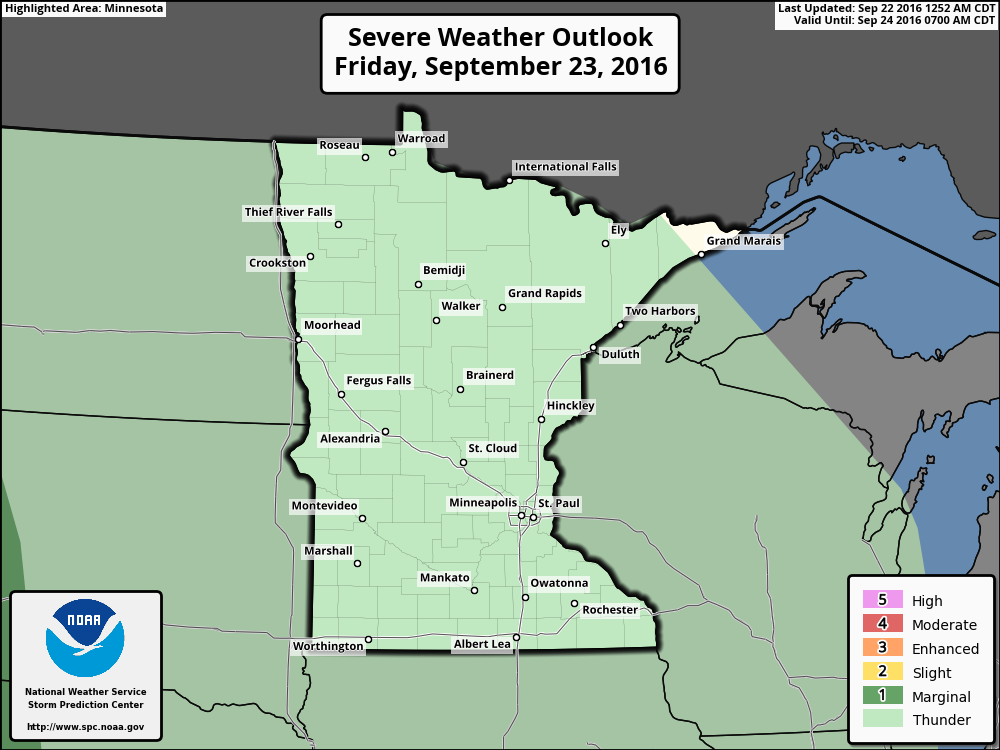
Severe Threat Friday
Although there isn't a severe weather concern on Friday, there still is a general thunderstorm threat, which could lead to a few areas of locally heavy rain across parts of the state later Friday.
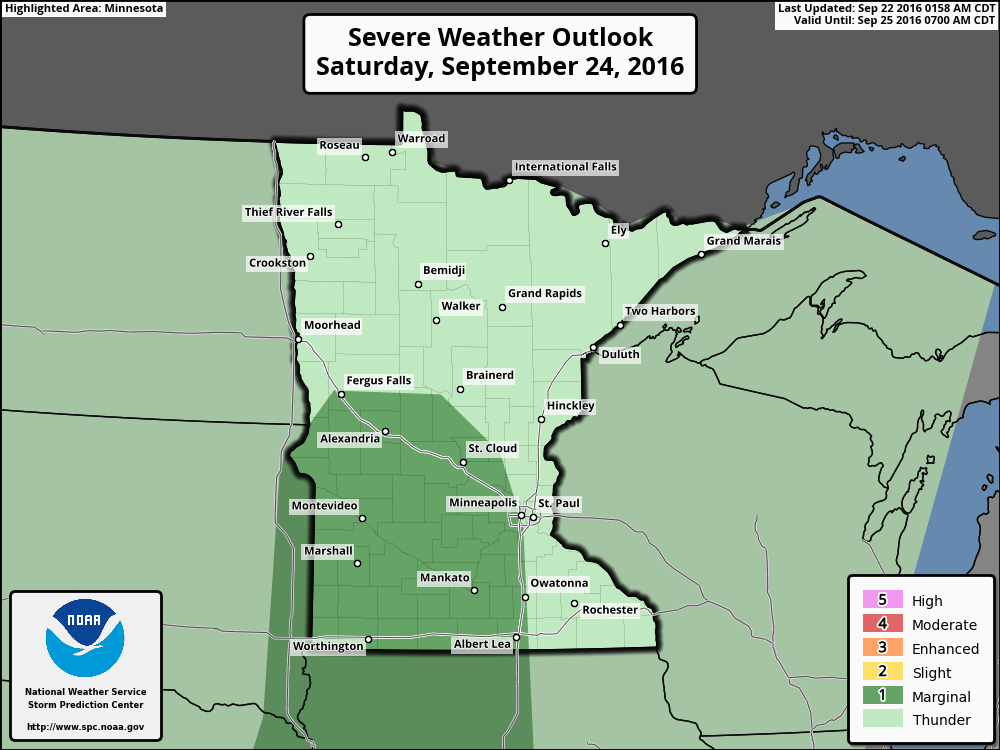
Severe Threat Saturday
...SRN PLAINS NNEWD INTO CNTRL MN... SFC DEWPOINTS IN THE 60S-70S F WILL ADVECT NNEWD ACROSS THE PLAINS TOWARDS THE UPPER MS VALLEY...AHEAD OF A COLD FRONT WHICH IS FORECAST TO EXTEND FROM THE FAR ERN DAKOTAS SSEWD ACROSS CNTRL KS INTO THE ERN TX PANHANDLE AT 24/18Z. SUFFICIENT HEATING SHOULD OCCUR TO SUPPORT MODERATE DESTABILIZATION AHEAD OF THE FRONT...AND WIDESPREAD TSTM DEVELOPMENT IS LIKELY TO OCCUR EARLY-MID AFTERNOON ALONG THE FRONT. A SUBSTANTIAL MERIDIONAL COMPONENT TO THE FLOW ACROSS THE CNTRL CONUS WILL SUPPORT QUICK EVOLUTION INTO AN EWD MOVING FRONTAL LINE...WITH THE POTENTIAL FOR STRONG WIND GUSTS...BUT HEAVY RAIN MAY BE THE DOMINANT THREAT. ONE RELATIVE EXCEPTION WHERE A CONDITIONALLY HIGHER SVR THREAT MAY EXIST IS ACROSS PARTS OF ERN NEB/NRN KS ALONG TRAILING PORTION OF THE STRONG NRN PLAINS MIDLEVEL SPEED MAX. THE RELATIVELY STRONGER FORCING FOR ASCENT AND TROPOSPHERIC WIND FIELDS MAY SUPPORT A BETTER THREAT FOR STRONG TO SVR CONVECTIVE WIND GUSTS...BUT CONFIDENCE IN THIS THREAT REMAINS TOO LOW FOR SLIGHT RISK DELINEATION IN THIS OUTLOOK.
7 Day Rainfall Outlook
According to NOAA's HPC, the 7 day rainfall forecast through the end of next week suggests more heavy rain across parts of the Upper Midwest, which could be up to 1" to 2"+ in some locations.
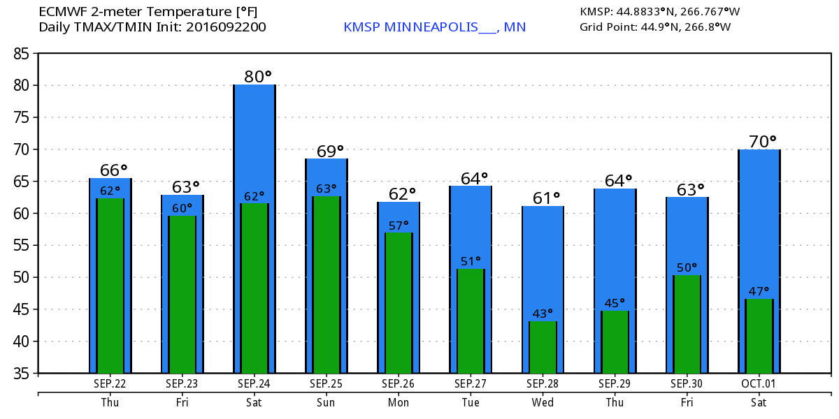
Extended Weather Outlook
The extended temperature outlook over the next 10 days suggests cooler than average temperatures through the end of the week, but a near 80F high temperature could be in our future on Saturday ahead a cold front that will bring us thunderstorms late Saturday. In the wake of the storm system, temperatures look to fall back into the 60s once again through much of next week.
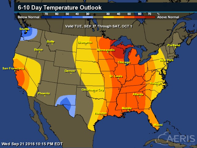
6 to 10 Day Temp Outlook
According to NOAA's Climate Prediction Center, warmer than average temperatures may sneak back into the Upper Midwest has we get closer to the end of the month/early part of October. However, next week looks a littler cooler and could require some longer sleeves.

6 to 10 Day Temp Outlook
Here's the national temperature outlook from September 27th to October 1st, which shows a blob of warmer than average temperatures from the Great Lakes to the Gulf Coast States.
__________________________________________
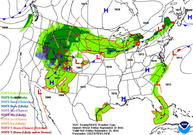
National Weather Outlook
Areas of heavy rain over the Upper Midwest begin to fade as another storm system moves into the region later Saturday. This is the same storm that is bringing snow the the Mountains out west. Some of the storms that develop on Saturday could be a little on the stronger side across parts of the Central U.S..
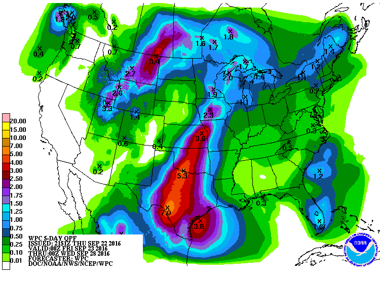
Precipitation Outlook
According to NOAA's WPC, the 5 day precipitation forecast shows heavy rain concerns across the Central U.S. and across parts of the Intermountain west and High Plains. Some areas here could see up to 2" to 4"+, which could lead to areas of additional flooding.
__________________________________________
KARL
This was the view of Tropical Storm Karl from Thursday evening. Karl regained tropical storm status after being downgraded to a depression earlier this week. The good news is that Karl poses no threat to the Lower 48, but could brush Bermuda with some tropical weather conditions.
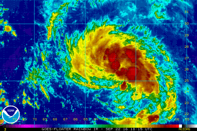
Tracking KARL
Tropical Storm Warnings have been issued for Bermuda as Karl makes a close encounter Friday into Saturday before moving into the north-central Atlantic.

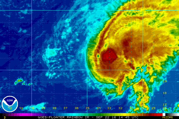
Tropical Storm Lisa
As of PM Thursday, Lisa was still a tropical storm, but the forecast track is not favorable for Lisa to pose any threats to the Lower 48.
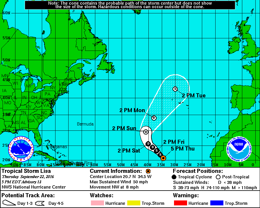
Tracking Lisa
Lisa will likely be downgraded to a depression by the weekend as it continues to lift north-northeast through the Central Atlantic.
__________________________________
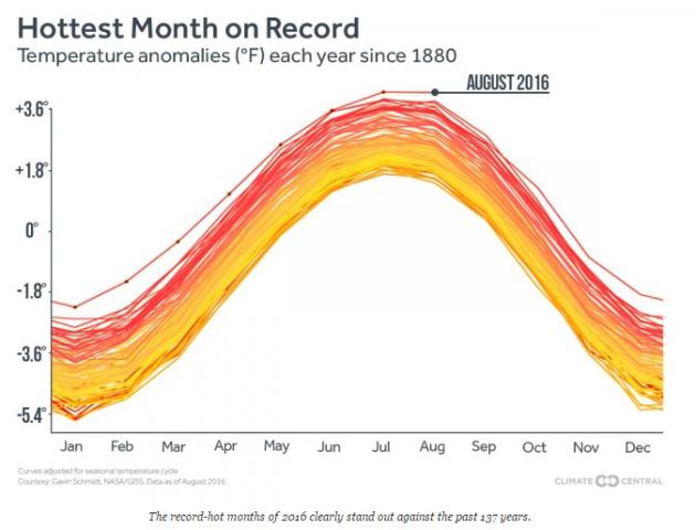
"Streak of Record-Hot Temps Adds Another Month"
"The unprecedented streak of record-hot months that the world has experienced over more than a year just tacked on one more month: Data released Tuesday by the National Oceanic and Atmospheric Administration showed last month was easily the hottest August on record. That makes 16 straight record-hot months, unparalleled in NOAA’s 137 years of record-keeping. The previous record streak was only 10 months, set in 1944. NASA’s data, released earlier, also said August was record hot, not to mention tying for the hottest month the planet has ever recorded."
_____________________________________
Thanks for checking in and have a great end of the week and weekend ahead!
Don't forget to follow me on Twitter @TNelsonWX
Don't forget to follow me on Twitter @TNelsonWX

No comments:
Post a Comment