Tracking HERMINE
Here's a look at Hurricane Hermine as it neared the Florida coastline PM Thursday. Outer bands began whipping the state early Thursday, some of which produced severe weather with tornadoes and locally heavy rain. Interestingly, HERMINE was the first hurricane to affect the state since Hurricane Wilma in 2005, 11 years ago.

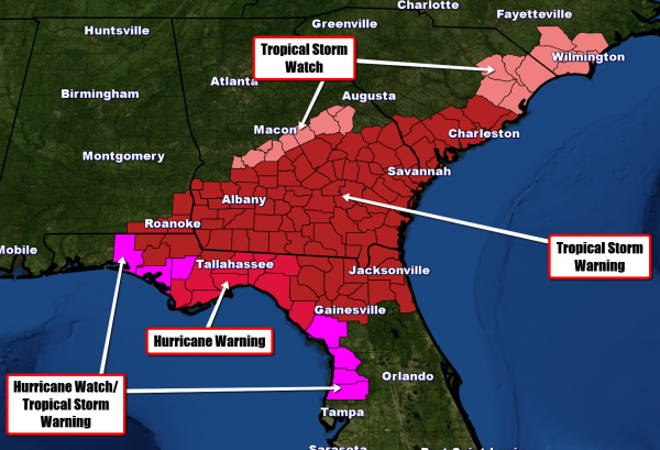
Topical Warnings
Tropical Warnings have been posted from the Panhandle of Florida to the Carolinas in advance of Hermine, which will make landfall Thursday night/early Friday morning with sustained winds around hurricane force and locally higher gusts. Storm surge up to 10ft.+ and flooding rains will be another major issues as Hermine continues to lift northeast through the end of the week/weekend.
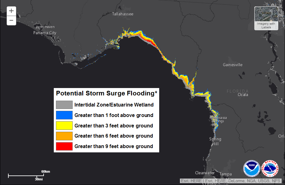
Storm Surge
The storm surge will initially be one of the main concerns Thursday night/early Friday morning as Hermine slams the Florida coast. Some spots could see up to 9ft.+ surge closer to where the eye makes landfall before fading as Hermine slides northeast during the day Friday.
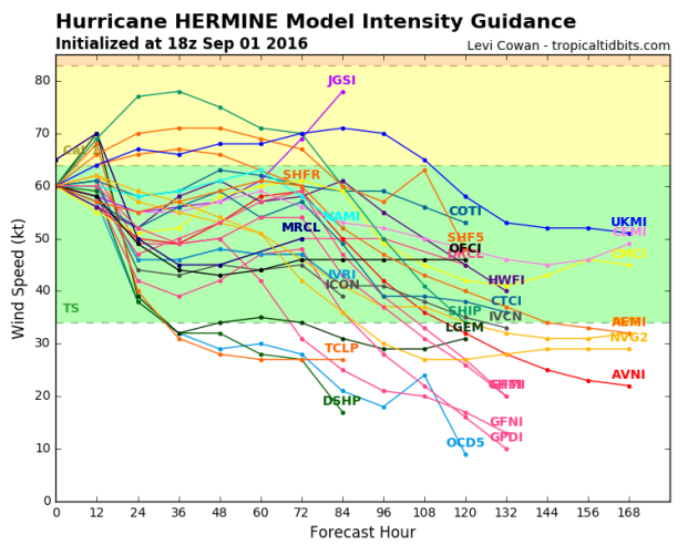
Intensity Model
The forecast intensity for Hermine suggests an overall diminishment in intensity over the next several days. The consensus here shows a fairly quick decrease to Tropical Storm strength over the next several days, only a few remain at or near hurricane strength.
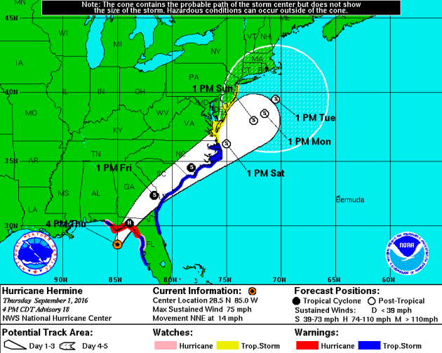
Tracking HERMINE
The forecast track from NOAA's NHC suggests that Hermine will fall back to Tropical Storm status after landfall on Friday. However, note that it may remain at Tropical Storm status through early Saturday as it hugs the Carolina coast. Gusty winds will persist here, but heavy rain will likely be one of the primary concerns and tropical moisture soaks the area. Note that the track slows a bit as we head into the weekend/early next week. If Hermine decides to sit off the Northeast/New England coast, heavy rain and a strong surf could be issues for folks along the coast through the middle part of next week.
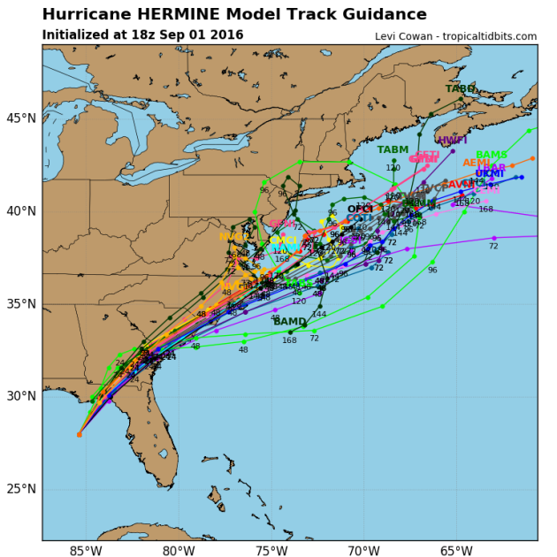
Spaghetti Plots
This is always an interesting graphic, the spaghetti plots, which show a number of different 'possible' tracks that Hermine could take according to a slew of different computer models. Note that the forecast seems pretty consistent as it moves over South Carolina, but begins to deviate considerably from then on. The good news is that the main consensus is that it will move out over the open waters of the Atlantic and not into the Northeast late week/early next week, though stayed tuned!
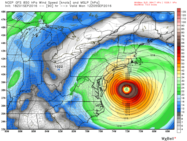
Tracking HERMINE
Here's a forecast view of Hermine early Monday morning, which shows a nearly stationary storm just off the Eastern Seaboard. This could complicate things a bit for folks along the coast through the middle part of next week with prolonged gusty winds, high coastal surf and heavy rain chances.
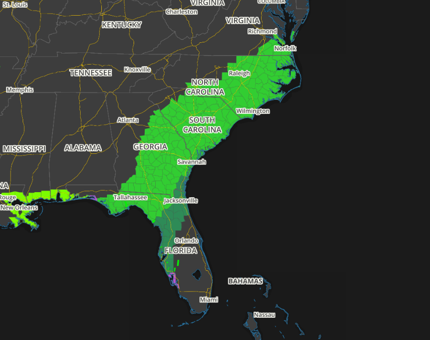
Flash Flood Concerns
Due to heavy rainfall chances, the National Weather Service has issued Flash Flood watches across a wide area from Florida to Virginia where several inches of rain could soak the region through the weekend.
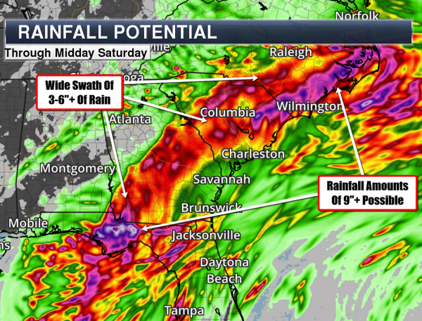
Heavy Rain Potential
One of the main concerns with this particular storm will be the significant rain chances through the next several days. some models suggests as much as 3" to 9"+, which could lead to widespread flooding from Florida to the Carolinas.
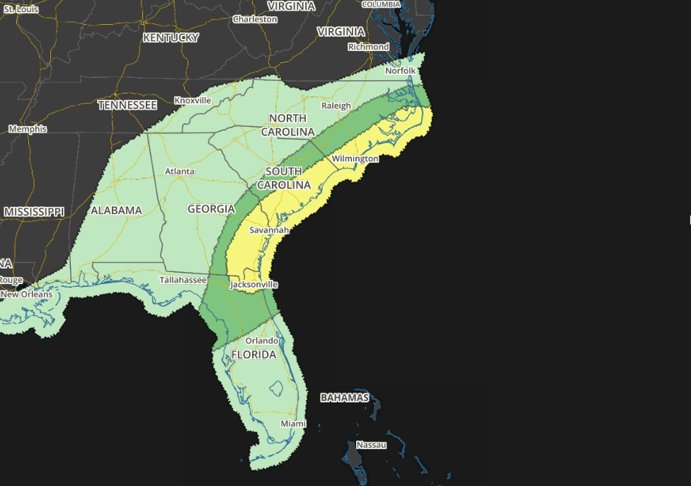
Severe Threat Friday
As Hermine slides northeast along the Eastern Seaboard, severe thunderstorms may accompany some the individual cells associated with the outer bands spiraling around the main are of circulation. Take a look at the severe threat on Friday and Saturday as issued from NOAA's SPC.
...SOUTHEAST... SOME ADJUSTMENTS TO THE CATEGORICAL AND PROBABILISTIC LINES HAVE BEEN MADE TO ACCOUNT FOR THE LATEST FORECAST TRACK. THE CENTER OF HERMINE APPEARS LIKELY TO REACH PORTIONS OF SOUTH CENTRAL/SOUTHEAST GEORGIA BY 12Z FRIDAY...BEFORE CONTINUING MORE RAPIDLY NORTHEASTWARD ALONG A TRACK NEAR OR JUST INLAND OF MUCH OF THE COASTAL CAROLINAS BY 12Z SATURDAY. AS IS TYPICALLY THE CASE WITH MOST TROPICAL SYSTEMS...THE EXTENT OF TORNADO POTENTIAL REMAINS UNCLEAR. HOWEVER...LARGE CLOCKWISE CURVED LOW-LEVEL HODOGRAPHS WITHIN THE FRONT RIGHT QUADRANT RELATIVE TO THE CENTER OF THE NORTHEASTWARD ACCELERATING TROPICAL CYCLONE WILL CERTAINLY BE CONDUCIVE TO THE RISK FOR TORNADOES IN THE PRESENCE OF HIGH BOUNDARY LAYER MOISTURE CONTENT. IT IS POSSIBLE THAT THIS RISK MAY BE MAXIMIZED AFTER DAYBREAK INTO MIDDAY FRIDAY ACROSS PARTS OF SOUTHEAST GEORGIA/ADJACENT NORTHEAST FLORIDA INTO COASTAL SOUTHERN SOUTH CAROLINA...AS AT LEAST WEAK INSOLATION BOOSTS BOUNDARY LAYER BUOYANCY.
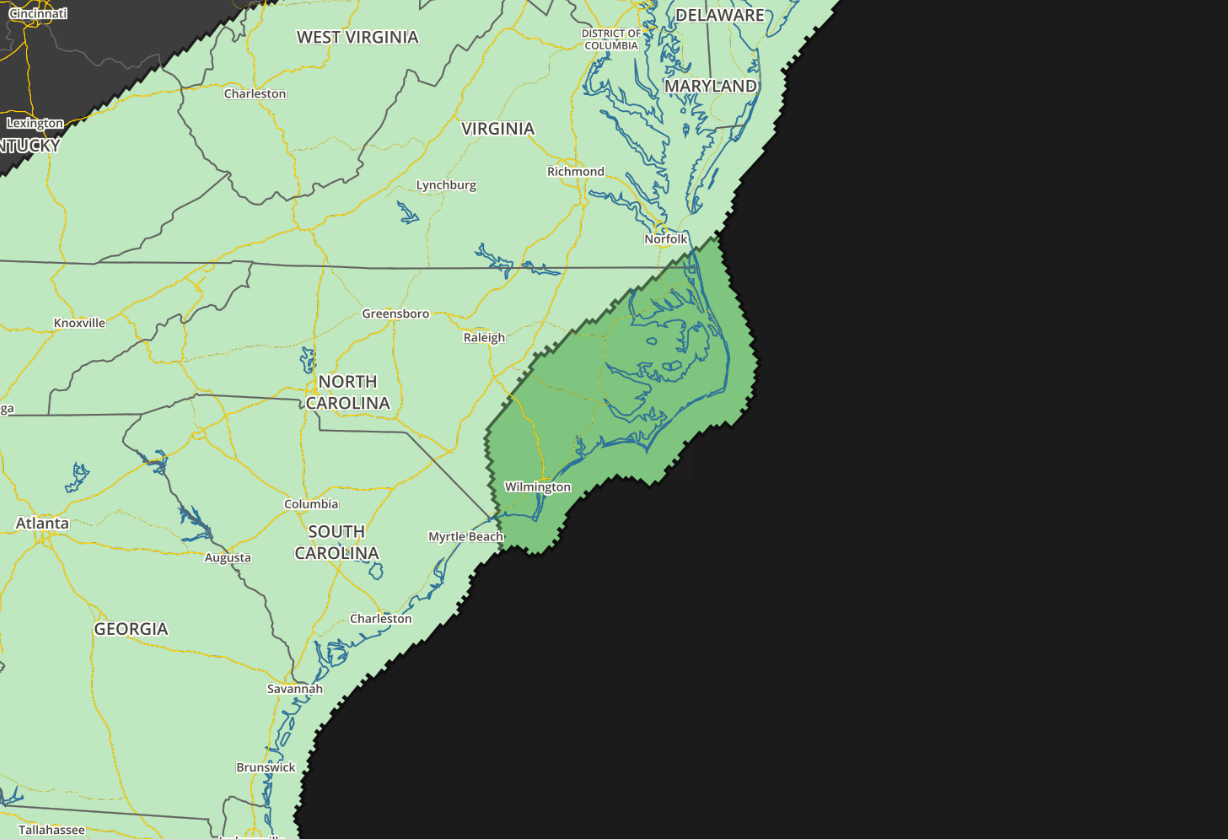
Severe Threat Saturday
...ERN NC... THE NATIONAL HURRICANE CENTER IS FORECASTING HERMINE TO BECOME A HURRICANE AND MOVE INLAND ACROSS FLORIDA AROUND 06Z ON FRIDAY...WEAKENING TO A TROPICAL STORM DURING THE DAY ON FRIDAY. BY 12Z/SATURDAY...THE CENTER OF HERMINE IS FORECAST TO BE IN SRN NC. NHC IS FORECASTING HERMINE TO BECOME EXTRA-TROPICAL ON SATURDAY WITH RAINBANDS TO THE EAST OF THE CENTER SPREADING NEWD ACROSS FAR ERN SC AND ERN NC. FORECAST SOUNDINGS IN ERN NC ON SATURDAY SHOW SFC DEWPOINTS IN THE MID 70S F...PRECIPITABLE WATERS NEAR 2.60 INCHES...SUBSTANTIAL DIRECTIONAL SHEAR IN THE LOW-LEVELS AND 0-1 KM SHEAR OF 30 TO 40 KT. THIS WOULD BE SUPPORTIVE OF AT LEAST A MARGINAL TORNADO THREAT WITH ROTATING STORMS TO THE NORTHEAST AND EAST OF HERMINE'S CENTER. ALTHOUGH THERE IS SOME UNCERTAINTY CONCERNING THE EXACT TRACK AND TIMING OF HERMINE...CONFIDENCE IS GREAT ENOUGH TO INTRODUCE A MARGINAL SEVERE THREAT ACROSS ERN NC VALID MAINLY FOR SATURDAY MORNING.
___________________________________________________
Prolonged Sunshine Turns To Scattered Storms
By Todd Nelson
By Todd Nelson
September 2nd? Seriously? What happened to summer? Don't get me wrong, I am a fan of all the seasons here in Minnesota, but I am not ready for all the months that end in 'ber' quite yet.
September, October and November mark the 3 months of meteorological fall. We have now surpassed the warmest 3 months, on average, for the northern hemisphere or meteorological summer: June, July and August. At this point, I am almost praying for a frost to take care of the swarming skeeter population that has flourished in the very wet July and August. Get this, Minneapolis saw nearly 13 inches of rain, which is 4.57 inches above average during that time period.
The extended forecast from late weekend into next week calls for another potentially substantial blob of heavy rain close to home as HERMINE in the southeast slows the weather pattern across the country. Our prolonged sunshine will last through Saturday and then turns unsettled with several shots of scattered storms and heavy pockets of rain.
In the meantime, keep the DEET handy!
____________________________
____________________________
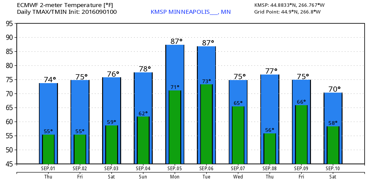
Extended Weather Outlook
THURSDAY NIGHT: Clear and comfortable. Winds: Light. Low: 55.
FRIDAY: Bright sun and beautiful. Winds: SE 7-12. High: 76
FRIDAY NIGHT: Partly cloudy, still quiet. Winds: SE 5-10. Low: 60.
SATURDAY: Sunniest, driest day of the holiday weekend. Winds: S 10-15. High: 78
SUNDAY: Warm and more humid. Spotty PM storms develop. Winds: SE 10-15. Wake-up: 61. High: 78
LABOR DAY: Unsettled. Wetter day of the Holiday weekend. Winds: S 7-12. Wake-up: 65. High: 80
TUESDAY: Scattered T-showers with heavier downpours. Winds: NE 5-10. Wake-up: 65. High: 78
WEDNESDAY: More showers and storms. Winds: SSW 5-10. Wake-up: 64. High: 80
THURSDAY: Lingering rumble. Drier PM. Winds: N 5-10. Wake-up: 64. High: 78.
_______________________________
_______________________________
This Day in Weather History
September 2nd
September 2nd
1996: Approximately 8 inches of rain falls over a 2 1/2 hour period in the Mankato area resulting in flash flooding. Numerous roads are closed, basements flooded, and $100,000 of damage results from a lightning strike in Lehiller.
1992: Severe weather affects several counties in the western parts of the County Warning Area. Several tornadoes are reported, along with 3/4 inch hail and damaging winds, as the system passes through Pope, Swift, Stearns, Kandiyohi, Meeker, Brown and Renville Counties.
1975: Severe weather rolls through Stevens, Swift, Kandiyohi, and Meeker counties. 1.5 inch Hail is reported in Stevens and Swift. An F1 tornado also occurs in Swift. An hour later, another F1 Tornado was reported in Kandiyohi County while 69 knot winds occurred in Meeker County. Damages were estimated at $50,000 for the two tornadoes that touched down.
1937: Strong thunderstorms bring heavy rainfall to northern Minnesota, with 4.61 inches of rain dumped on Pokegama. Flooding was reported in Duluth.
________________________________
________________________________
Average High/Low for Minneapolis
September 2nd
September 2nd
Average High: 77F (Record: 97F set in 1937)
Average Low: 58F (Record: 42F set in 1974)
_________________________________
Average Low: 58F (Record: 42F set in 1974)
_________________________________
Sunrise/Sunset Times for Minneapolis
September 2nd
September 2nd
Sunrise: 6:37am
Sunset: 7:47pm
Sunset: 7:47pm
*Daylight Lost Since Yesterday: ~3mins & 1sec
*Daylight Lost Since Summer Solstice: ~2hours and 24mins
__________________________________
*Daylight Lost Since Summer Solstice: ~2hours and 24mins
__________________________________
Moon Phase for September 2nd at Midnight
1.9 Days Since New Moon
1.9 Days Since New Moon

_____________________________________
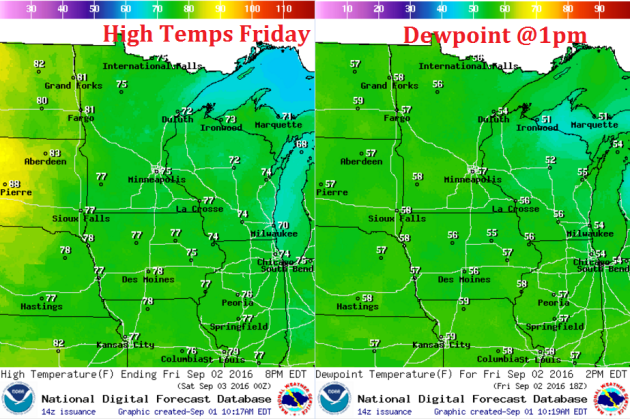
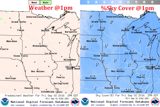
Weather Outlook Friday
High temperatures on Friday near near average and very similar to what we had on Thursday! With dewpoints in the 50s and highs in the 70s, Friday will be another beautiful early September day. Enjoy!
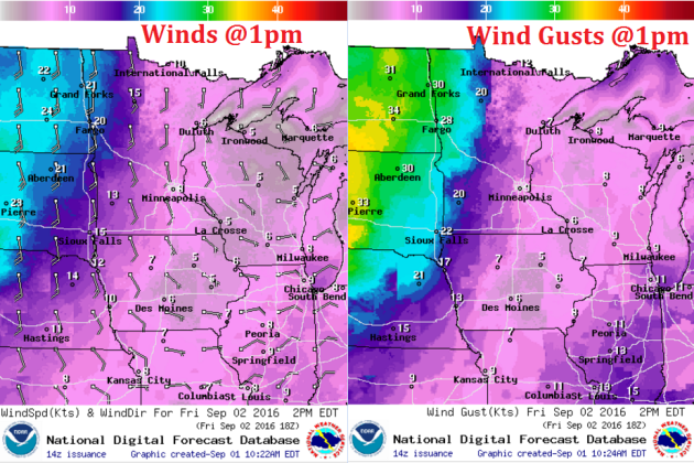
Weather Outlook Friday
An area of high pressure will wedge itself over the Great Lakes over the next few days allowing sunshine and light winds to persist there. Note that winds will be considerably stronger across far western and the Dakotas as the pressure gradient tightens between the high pressure over the Great Lakes and a trough of low pressure in the Pacific Northwest.
Weather Outlook
Friday will be another very nice day with only a few fair weather cumulus clouds developing during the day. Most of these clouds will melt away as we lose the daytime heating late in the afternoon/evening.
Simulated Radar
The simulated radar from PM Thursday to PM Saturday suggests quiet conditions persisting through Friday and for much of Saturday, however, it appears that a few spotty showers/storms may start to develop and spread through the regions as we approach the late weekend timeframe.
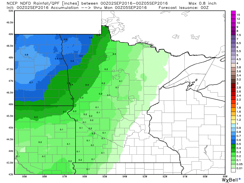
Rainfall Potential
Here's the rainfall potential through PM Sunday, which suggests a little moisture starting to move into the western part of the state by late weekend. Note that rainfall tallies don't appear to be all that impressive, however, more substantial rainfall could move in as we head into next week.
__________________________________________
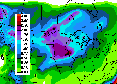
7 Day Rainfall Outlook
The sunny, dry, comfortable weather as of late certainly has been a treat. Enjoy it while you can because unsettled and wetter weather returns late weekend into next week. According to NOAA's WPC, the 7 day rainfall forecast suggests fairly widespread 1" to 2"+ rainfall through the end of next week.
Extended Weather Outlook
The extended temperature outlook through the first full week of September suggests a bit of a warm up early/mid next week with muggier dewpoints accompanying the brief warm up. However, it appears that it won't last too long as readings settle back to near normal levels by the end of the week.
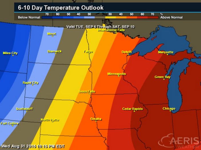
6 to 10 Day Temp Outlook
According to NOAA's CPC, the 6 to 10 day temperature outlook suggests a fairly decent chance of warmer than normal conditions settling in around the Great Lakes Region during the first full week of September. A bigger blob of cooler air will settle in across the Northwestern part of the country, which may drift our way as we approach the 2nd weekend of the month.
___________________________________________
National Weather Outlook
The national weather outlook shows Hermine lifting northeast along the coast, which in turn will have impacts across the rest of the nation. Tropical systems tend to have ripple effects on other weather systems, so things don't move along as quickly as they otherwise would. High pressure will linger a little longer across the Great Lakes and unsettled, wetter weather will linger across the Plains over the next few days as Hermine creates a traffic jam in the East.
Precipitation Outlook
According to NOAA's WPC, the 5 day forecast suggests heavier rain continuing along the Eastern Seaboard as Hermine lifts northeast along the coast. Meanwhile, dry weather persists in the Great Lakes and Ohio Valley as high pressure dominates. Persistent showers and storms will find themselves through the Intermountain-west and into the Midwest through early next week.
______________________________________
Lester in the Pacific
Here's a view of Hurricane Lester in the Central Pacific Ocean, which will be bearing down on the Hawaiian Islands as we head into the weekend. As of PM Thursday, Lester was a category 3 hurricane with sustained winds of 120mph with a very defined eyewall; see below.
Tracking Lester
According to NOAA's CPHC, Lester will make a very close call with the Hawaiian Islands, but still bring some fairly significant impacts to those areas. Hurricane Watches have been posted for The Big Island and Maui.
_________________________
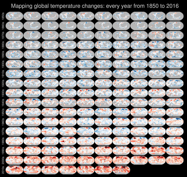
"How Quickly Climate Change Is Accelerating, in 167 Maps"
"WHEN IT COMES to explaining climate change, it helps to have clear, convincing evidence on hand. Ed Hawkins, a climate scientist at the University of Reading with a knack for data-visualization, specializes in precisely this kind of evidence. Perhaps you’ve seen his work. His “Spiraling global temperatures” animation, which depicts a rainbow-colored record of global temperatures coiling outward at an accelerating pace, went viral back in May. It even made an(unexpected) appearance at the Olympic Opening Ceremonies in Rio. His latest visualization, “Mapping global temperature changes,” is less abstract, but conveys a similar sense of urgency. The infographic combines 167 global temperature maps—one for every year from 1850 to 2016—into a single chart. Those maps (Robinson1 projections, for those wondering) come from HadCRUT4, a gridded, color-coded dataset of global surface temperatures produced by the Met Office Hadley Centre for Climate Change. If you hover your cursor over the visualization at the top of this post, you’ll see that each map is divided into pixels colored varying shades of red and blue. Blue signifies cooler temperatures (relative to a 1961-1990 reference period) and red warmer ones. If a cell is grey, it indicates there was insufficient data to determine its color for that year."
_________________________________________
"Natural Gas Emissions to Surpass Those of Coal in 2016"
"The U.S. is expected to reach a major carbon emissions milestone this year: For the first time, carbon dioxide emissions from burning natural gas for electricity in the U.S. are set to surpass those from burning coal — the globe’s chief climate polluter. Emissions from burning natural gas are expected to be 10 percent greater than those from coal in 2016, as electric companies rely more on power plants that run on natural gas than those that run on coal, according to U.S. Department of Energy data. In 2015, the U.S. used about 81 percent more natural gas than coal for electricity, but because coal contains more carbon than natural gas does, emissions from burning both were about the same. Natural gas consumption is expected to continue rising, however, and the EIA expects the U.S. will emit about 1.5 billion metric tons of carbon dioxide from natural gas in 2016, compared to about 1.4 billion metric tons from coal."
See more from Climate Central HERE:
See more from Climate Central HERE:
The H.F. Lee natural gas power plant near Goldsboro, N.C. Credit: Duke Energy/flickr

"One Glorious Map Shows the Future of Animal Migrations"
"The natural world is under siege by climate change. Rising temperatures are pushing plants and animals outside their current range. To keep pace with climate change, species will need a path to follow northward or up in elevation, minimally interrupted by human development. This map shows that path (well, paths actually) in the most beautiful way possible. It uses the dreamy Earth wind map for inspiration. But rather than using temperature, wind and sea level pressure data, Dan Majka, a web developer at The Nature Conservancy, used data from two studies to show all the feasible paths that mammals, birds and amphibians can use to find their way to a more suitable climate as their habitat becomes too hot. The map doesn’t show specific species (you’re not going to be able to find the grizzly bear path, for example), but rather shows the general patterns scientists expect animals to follow as the world warms. The visualization is stunning, but also hopeful. It shows that despite the challenges of climate change and increased urbanization, there are still pathways for the natural world to deal with those threats. Zoomed out, it’s clear that the Appalachians are a crucial funnel for climate-induced migration. They’re smack dab in one of the most developed parts of the country and represent some of the last wild land in the eastern U.S. “Much of the land outside of the mountain range is developed or in agriculture,” Brad McRae, an ecologist with the Nature Conservancy, said. “So as species ranges shift north, the Appalachians are providing some of the least-developed routes for movement. They also provide some climate relief due to their high elevation.”"
See more from Climate Central HERE:
"A map showing the different pathways wildlife could use to migrate northward or higher in elevation as the climate warms.Credit: The Nature Conservancy"
___________________________________________
Thanks for checking in and have a great end of your week and weekend ahead!
Don't forget to follow me on Twitter @TNelsonWX
Don't forget to follow me on Twitter @TNelsonWX

No comments:
Post a Comment