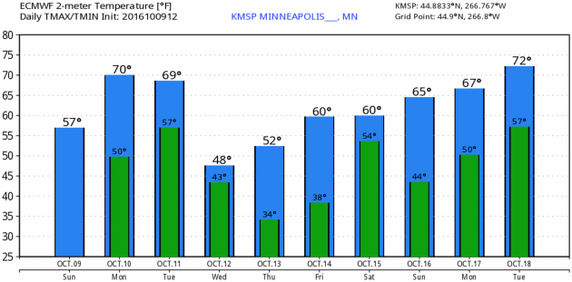
TODAY: Mild wind, late shower? Winds: S 15-25. High: near 70
MONDAY NIGHT: Patchy clouds, passing shower (best chance south/east of MSP). Low: 54
TUESDAY: Clouds increase, few showers. Winds: SW 8-13. High: 66
WEDNESDAY: Steadier rain tapers, turning cooler. Winds: NW 10-20. Wake-up: 45. High: 53
THURSDAY: Frosty start, cool-blue sky. Winds: SE 5-10. Wake-up: 35. High: 57
FRIDAY: Partly sunny, milder breeze. Winds: S 10-15. Wake-up: 43. High: 62
SATURDAY: Early sun, few showers possible late. Winds: S 10-20. Wake-up: 53. High: 69
SUNDAY: Mix of clouds and sun, cooler. Winds: E 5-10. Wake-up: 58. High: 63
Delayed Harvests - Recovering from a Wet September
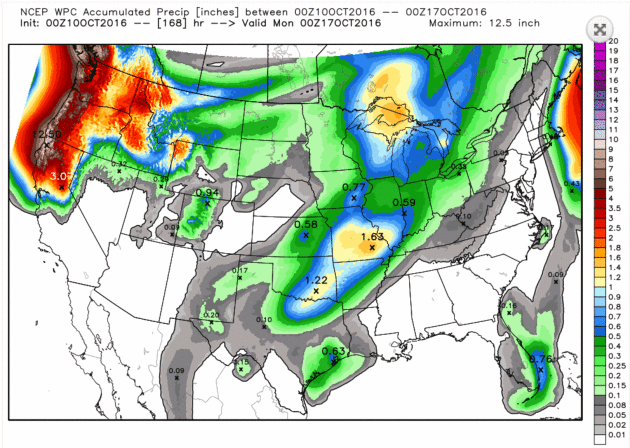
Statewide it was the 10th wettest September since 1895, according to the Minnesota Climate Office. But that's an average; some towns in southern Minnesota picked up 4-5 times more rain than average.
I'm hearing from frustrated farmers, including Kevin Busch down in Worthington. "We have water standing everywhere. It seems like we will have absolutely no chance of harvesting until the ground freezes or we get a 1-2 week period of NO rain. Is this even possible?" Busch asked. Gazing at the maps I'm not so sure.
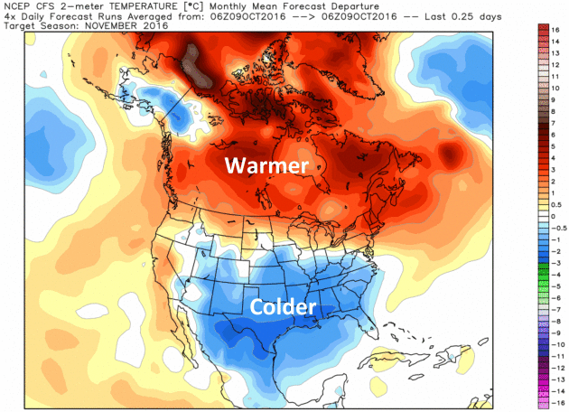
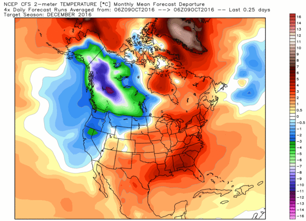
2016 will almost certainly be one of the 3 wettest years on record across Minnesota. This milder, wetter bias should spill into the winter months - but a broader warming trend could favor a mix of snow, ice and even rain in the months to come.
That said, winter hasn't been cancelled. If we ever skip winter the planet will have much bigger problems.
A few quick shots of colder air are brewing, but I don't see prolonged spells of numbing weather. The chance of showers increases tonight into Wednesday. After a frosty Thursday morning temperatures mellow to near 70F by late week.
Wearing a jacket over your shorts? Welcome to October.

Range Is All The Rage in Paris, as Electic Cars Steal the Show. The New York Times reports: "For perhaps the first time at a major international auto salon, the stars of the Paris Motor Show are electric cars.
The 2016 show, open to the public through Oct. 16, also has the usual
sampling of futuristic designs and prototypes. And of course there are
some conventional new models soon to hit dealer showrooms. But this show
may end up being best remembered as a tipping point for an electric car
revolution poised to challenge the automobile industry’s
internal-combustion status quo — although some of the excitement is
still speculative, of course..."
Photo credit: "The Paris Motor Show runs through Oct. 16." Credit Michel Euler/Associated Press.
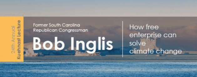
24th Annual Kuehnast Lecture at University of Minnesota on Wednesday.
I'm looking forward to introducing one of my heroes, Rep. Bob Inglis
from South Carolina, who is leading the effort to find a conservative
solution to climate change. Here's an excerpt from Dr. Mark Seeley at WeatherTalk: "...The 24th Annual Kuehnast Endowment Lecture
will take place on Wednesday, October 12th at 2pm in the University of
Minnesota St Paul Campus Student Center Theater. Our topic this year is
“Climate Change and the American Free Enterprise System.” Our speakers
are Paul Douglas, former Twin Cities broadcast meteorologist and
President of Aeris Weather; and Bob Inglis, former South Carolina
Republican Congressman and founder of RepublicEn.org, which is centered
on conservative principles and a free-enterprise solution to climate
change. This program is free and open to the public."
* More details on the Kuehnast Lecture Series and how you can participate here.
Climate Stories....

Photo credit: Shutterstock.
A Military View on Climate Change: It's Eroding Our National Security and We Should Prepare for It. A friend of mine, fellow Penn Stater Admiral David Titley (retired) has the story for The Center for Climate and Security; here's the intro: "In this presidential election year we have heard much about some issues, such as immigration and trade, and less about others. For example, climate change was discussed for an estimated 82 seconds in the first presidential debate last week, and for just 37 minutes in all presidential and vice presidential debates since the year 2000. Many observers think climate change deserves more attention. They might be surprised to learn that U.S. military leaders and defense planners agree. The armed forces have been studying climate change for years from a perspective that rarely is mentioned in the news: as a national security threat. And they agree that it poses serious risks..."
No comments:
Post a Comment