Lingering Snow in the Northeast
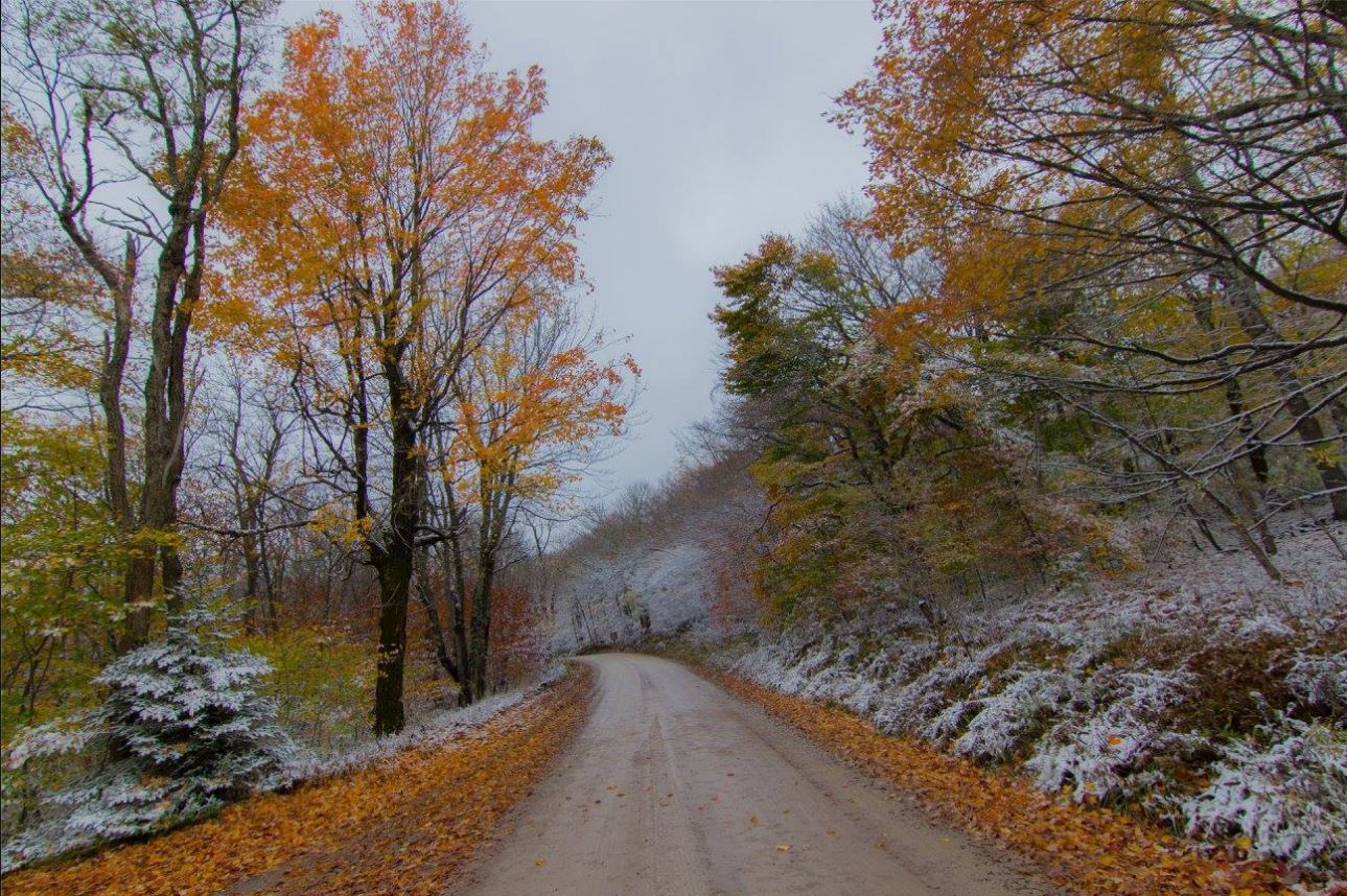
What a beautiful picture from the National Weather Service out of Charleston West Virginia. Here's what they had to say: "Fall foliage and snow scene taken by one of our own forecasters Sunday, along the South Fork of Red Creek, in the mountains northeast of Elkins, West Virginia."
Lingering Snowfall in the Northeast
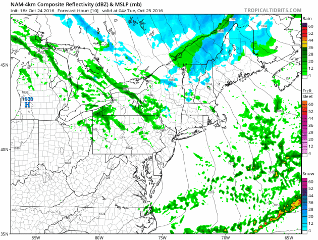
A large storm system swirling in eastern Canada will continue to keep scattered rain and snow showers in the forecast through the middle part of the work week. However, note the next blob of moisture moving in from the west, the may help to add to the snowfall tallies across parts of the Northeast through the end of the week.
Additional Snowfall
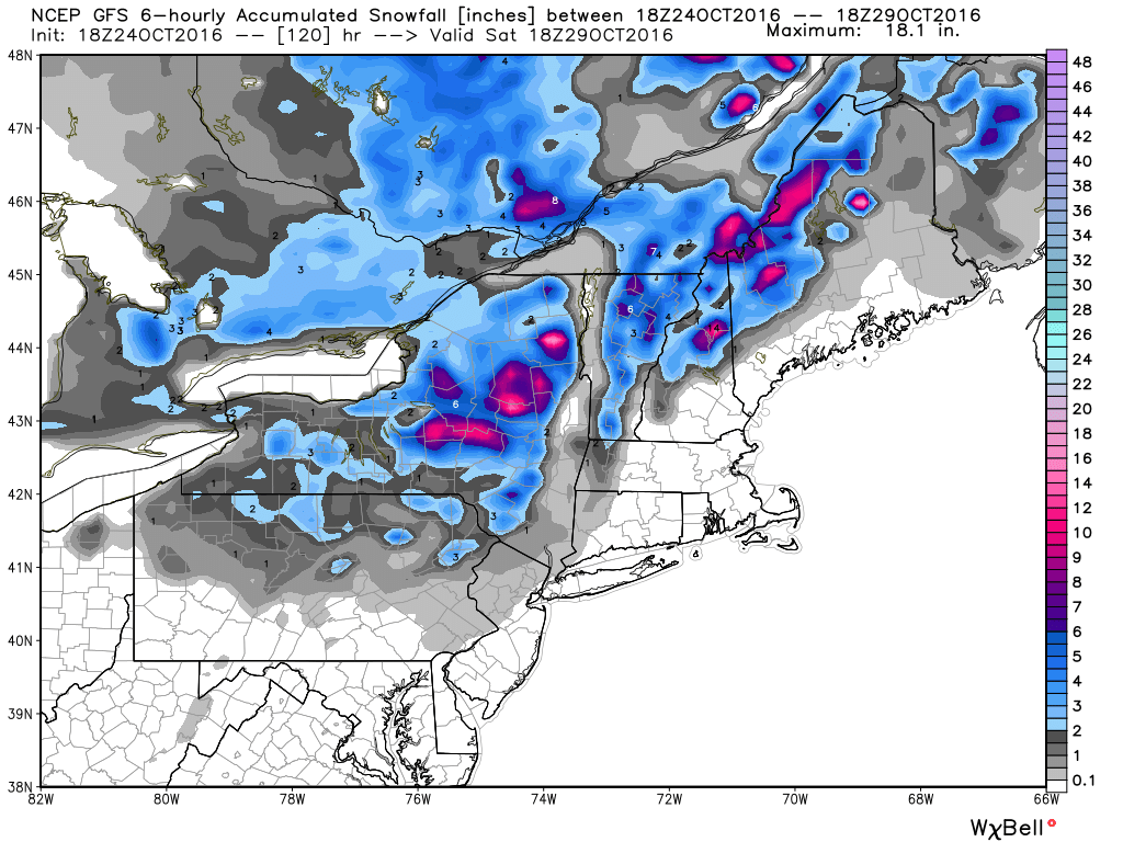
Much of the snow from the weekend has tapered, but another surge of moisture will push in by the end of the week/weekend ahead with enough lingering cold air to turn it into additional snowfall across the far north and high elevations!
Colder Than Average in the Northeast
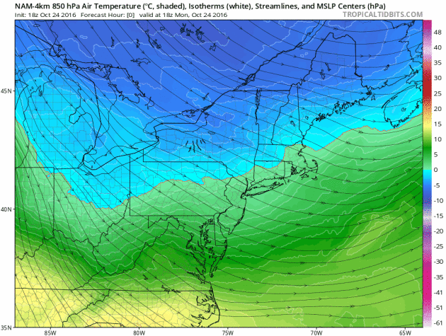
Temps will remain quite chilly across the Northeast over the next several days as the trough of low pressure continues to cycle down colder Canadian.
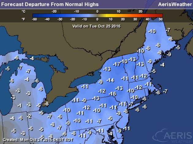
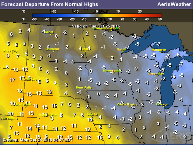
 Highs From Average in the Northeast Tuesday
High temperatures on Tuesday will be running nearly 10F to 15F below average. It appears that temps will remain cooler than average for much of the week before getting closer to average by Saturday.
 _____________________________________________________________________________
What a beautiful picture from the National Weather Service out of Charleston West Virginia. Here's what they had to say: "Fall foliage and snow scene taken by one of our own forecasters Sunday, along the South Fork of Red Creek, in the mountains northeast of Elkins, West Virginia."
Lingering Snowfall in the Northeast
A large storm system swirling in eastern Canada will continue to keep scattered rain and snow showers in the forecast through the middle part of the work week. However, note the next blob of moisture moving in from the west, the may help to add to the snowfall tallies across parts of the Northeast through the end of the week.
Additional Snowfall
Much of the snow from the weekend has tapered, but another surge of moisture will push in by the end of the week/weekend ahead with enough lingering cold air to turn it into additional snowfall across the far north and high elevations!
Colder Than Average in the Northeast
Temps will remain quite chilly across the Northeast over the next several days as the trough of low pressure continues to cycle down colder Canadian.
High temperatures on Tuesday will be running nearly 10F to 15F below average. It appears that temps will remain cooler than average for much of the week before getting closer to average by Saturday.
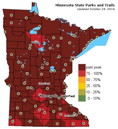
Fall Color Update
Colors are fading fast across the state with many locations already reporting past peak conditions. There are still a few spots across the southern part of the state that are currently peaking!
___________________________________________________
Wet Leaf Alert! Steady Rains Develop PM TuesdayOne of my favorite memories as a kid was jumping into a big fat pile of freshly raked fluffy leaves. It never got old getting lost in that rusty colored heap of crunchy, musty smelling foliage. The one thing I hated, though, was how slimy they seemed to get after a steady October rain.
Wet leaf puddles will be bountiful later Tuesday as a waterlogged storm system blows in from the west. Latest model runs suggest nearly 1 inch of rain or more across the southern part of the state by midday Wednesday. I could even see a few wet snowflakes mixing in across the Arrowhead and northern Wisconsin by early Wednesday morning.
Drier winds return later this week and turn out of the south, which will help to push the mercury up to near 60 degrees Friday. Unfortunately, it'll be short lived. Another cold front slaps us with brisk winds on Saturday. A few more flakes will be possible up north this weekend and most across the state could see frost Sunday morning.
Weather maps are slowly starting to change, but nothing major is brewing just yet.
___________________________________________________
Extended Weather Outlook
MONDAY NIGHT: Increasing clouds. Winds: E 5. Low: 38.
TUESDAY: Steady PM rains develop, heavier in southern Minnesota. Winds: ESE 10-15. High: 50
TUESDAY NIGHT: Scattered showers. Winds: ESE 10-15. Low: 42.
WEDNESDAY: Showers early, lingering PM puddles. Winds: NNE 5-10. High: 50
THURSDAY: Filtered sunshine. A little warmer. Winds: S5-10. Wake-up: 40. High: 57
FRIDAY: Winds pick up. Clouds increase late. Winds: WNW 10-20. Wake-up: 45. High: 60.
SATURDAY: Chilly breeze. A few AM flurries up north? Winds: N 5-15. Wake-up: 41. High: 49.
SUNDAY: Frosty start for most. Afternoon sun. Winds: SSE 5-10. Wake-up: 35. High: 52.
Halloween Monday: Spooktacular. More wind. Few showers? Winds: SSE 10-15. Wake-up: 39. High: 55.
_______________________________
_______________________________
This Day in Weather History
October 25th
1887: Albert Lea sets a record low of -6 degrees F.October 25th
1830: A 'heat wave' hits Ft. Snelling. The high temperature reached 80.
________________________________
Average High/Low for Minneapolis
October 25th
Average High: 54F (Record: 82F set in 1989)
Average Low: 37F (Record: 12F set in 1887)
_________________________________
Average Low: 37F (Record: 12F set in 1887)
_________________________________
Sunrise/Sunset Times for Minneapolis
October 25th
October 25th
Sunrise: 7:42am
Sunset: 6:11pm
Sunset: 6:11pm
*Daylight Lost Since Yesterday: ~2mins & 54sec
*Daylight Lost Since Summer Solstice: ~5hours and 9mins
______________________________________________________________________
*Daylight Lost Since Summer Solstice: ~5hours and 9mins
______________________________________________________________________
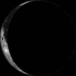
Moon Phase for October 24th at Midnight
2.5 Days After Last Quarter
2.5 Days After Last Quarter
Weather Outlook Tuesday
High temperatures on Tuesday will be running at or slightly below average across much of the state ahead of a storm system that will bring scattered rain showers PM Tuesday - Wednesday.
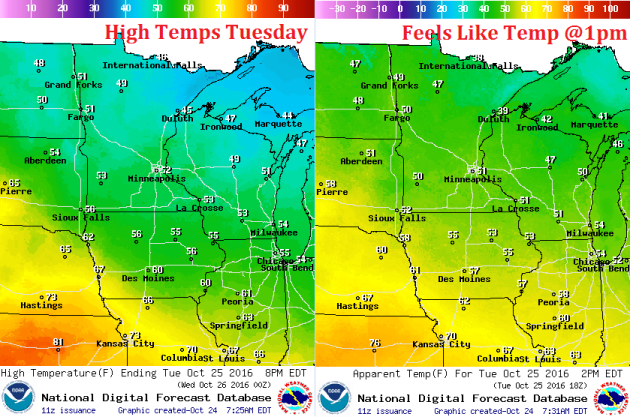
High Temperatures From Average Tuesday
Here's a look at high temps from average on Tuesday, which shows readings at or slightly below average across much of the state.
Weather Outlook Tuesday
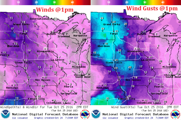
After a relatively quiet day Monday, winds will start to pick up across the region on Tuesday as our next storm system approaches from the west. Some wind gusts could approach 20mph+ across the western part of the state.
Weather Outlook Tuesday
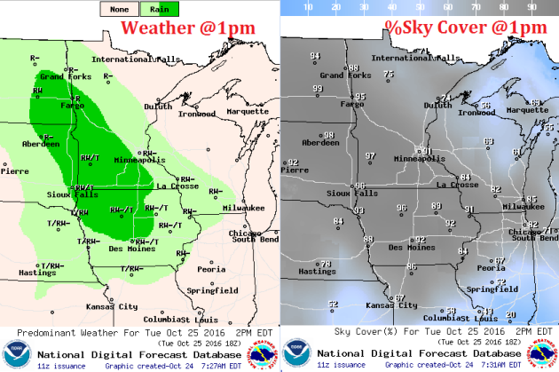
After a sunny Monday, clouds increase Tuesday in advance of scattered rain showers that will push through the region PM Tuesday - Wednesday. Some of the rain could be heavy across the southern half of the state through midweek.!
___________________________________________________________
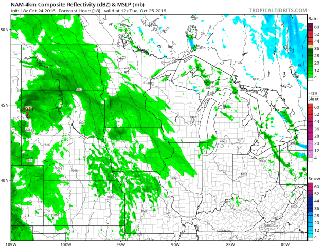
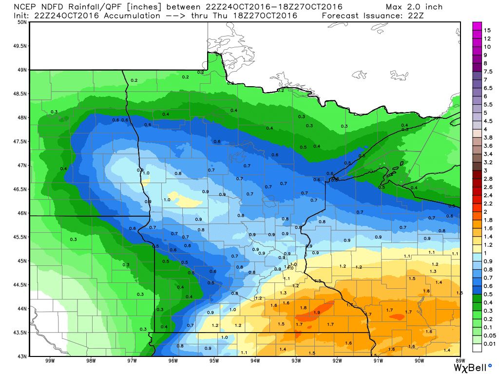
PM Tuesday - Wednesday Rain Potential
Here's our next storm system that will move through parts of the Midwest PM Tuesday - Wednesday. Note that the center of the storm looks to stay well south of Minnesota, which may help to limit heavy rain chances across the northern half of the state. The heaviest rain will likely be found across extreme southern Minnesota, northern Iowa and into southern Wisconsin.
Rainfall Potential
The next batch of rain will start to move in across the southern half of the state PM Tuesday. According to latest model runs, some spots could see as much as 1" to 2" across southeastern MN by mid/late week.
________________________________________
Extended Weather Outlook
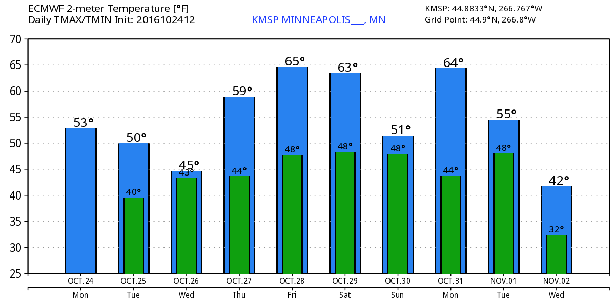
The extended temperature outlook over the next 10 days suggests a gradual cooling trend over the next few days before bottoming out in the mid 40s mid week. As we approach next weekend, temperatures look to rebound back into the upper 50s to near 60F, which will be above average once again.
Warm Temperatures Return to Midwest
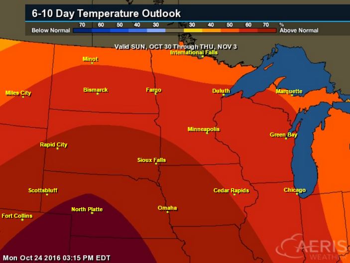
According to NOAA's CPC, the 6 to 10 day temperature outlook suggests warmer than average temperatures continuing across much of the Upper Midwest as we approach the end of the month. It may be a mild Halloween this year... stay tuned!
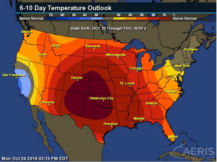
Here's the national temperature outlook from October 30th - November 3rd, which shows warmer than average conditions across much of the nation.
__________________________________________
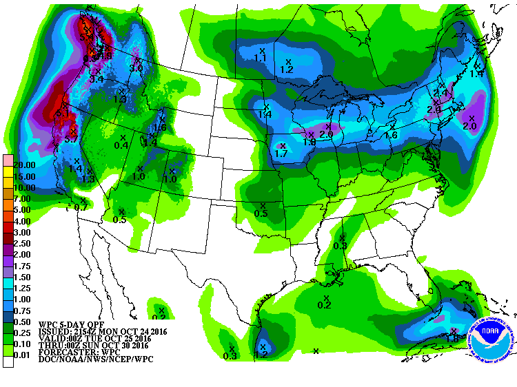
National Weather Outlook
A large storm system in eastern Canada will begin to subside over the next couple of days, but cool temps will linger there. Meanwhile, a storm system will push through the Central U.S. with pockets of heavy rainfall and isolated strong storms. A series of storms will batter the West Coast with heavy rainfall and gusty winds.
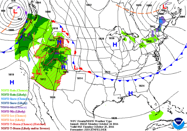
Precipitation Outlook
According to NOAA's WPC, heavier rainfall will be found from parts of the Upper Midwest to the Northeast. The heaviest rainfall will be found along the West Coast wil some 3" to 6"+ rainfall tallies there.
 ______________________________________________
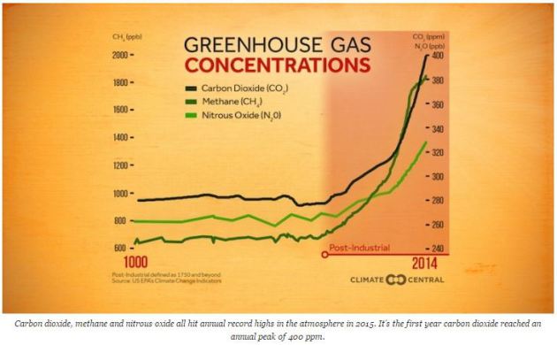
"Carbon Dioxide Passed Critical Threshold in 2015"
"On Monday, the World Meteorological Organization released another reminder of the planetary predicament we’re in: The earth’s atmosphere permanently passed the 400 parts per million (ppm) threshold last year. It’s the first year in human history where carbon dioxide levels have reached the symbolic milestone for an entire year. But it certainly won’t be the last as humans continue to treat the atmosphere as a waste dump for carbon pollution. You might have heard that the world reached the 400 ppm milestone permanently this September. And it did, according to data collected at Mauna Loa Observatory, which is considered the gold standard for carbon dioxide monitoring. But it’s not the only place in the world where scientists are monitoring carbon dioxide. The WMO monitors a network of 123 stations from pole to pole. And because carbon dioxide doesn’t mix evenly in the atmosphere, some have been well above 400 ppm for awhile while others have only reached the plateau for a few months a year recently. Average them together over the year and voila, you have a recipe for a more complete snapshot of the entire atmosphere."
____________________________________________________________________
Thanks for checking in and don't forget to follow me on Twitter @TNelsonWX
No comments:
Post a Comment