54 F. maximum temperature on Saturday in the Twin Cities.
43 F. average high temperature on November 12.
45 F. high on November 12, 2015.
November 13, 1986: Lakes are frozen over throughout much of the state, reaching as far south as Winona.
November 13, 1938: A snowstorm develops across northern Minnesota. The barometer falls to 29.31 inches in Duluth.
November 13, 1933: The first Great Dust Bowl Storm occurs. The sky darkened from Minnesota and Wisconsin to New York State.
Typical for North Texas - 222 Day Growing Season at MSP?I'm
an old Eagle Scout; if it wasn't for weather merit badge and a tropical
storm named Agnes I might have a real job right now. Why weather? The
intellectual challenge of predicting the future and a secondary
challenge of communicating weather; framing the story differently for
each unique audience and need.
Increasingly, the expression
"average weather" is losing its meaning. 30-year climate numbers are
being nudged by a warmer, wetter, more volatile climate system. Much of
Minnesota has experienced a first frost, but not the downtowns, close-in
suburbs or MSP International Airport, where official temperature
records are kept.
This year the first sub-freezing low should come
next Sunday morning,
November 20. That implies a 222-day
growing season
in 2016. That's average for the northern suburbs of Dallas, Texas. On
paper the Twin Cities have an average frost-free growing season of 154
days. Right.
Expect 60s today, showers
Tuesday, then a windblown soaking rain
Friday, ending as snow flurries late. By next weekend you'll need a heavy jacket again.
Minnesotans wear heavy jackets in November, right?
 Warmest First 10 Days of November
. So says Dr. Mark Seeley in this week's installment of
Minnesota WeatherTalk: "
The
remarkable warmth so far this month is record-setting. For example in
the Twin Cities, the average temperature for the first ten days of
November is 53.7. This is nearly 14F above normal and surpasses the
other warm first ten days of November which occurred in 1975, 2001, and
2015. This pattern is holding true at a number of locations around the
state, including International Falls where the first ten days of
November are average close to 46F also about 14F above normal. This too
surpasses the other warmest Novembers of 1964, 1975, and 2015. So far
this month 32 daily high temperature records have been set within the
Minnesota Cooperative Weather Observer Network across the state,
including a remarkable reading of 78F at Mora..."
Unseasonable Warmth Lingers Over Northern Hemisphere.
At some point a weak to moderate La Nina phase of ENSO may cool things
down, but I'm still struck by how much warm air there is, especially
across Canada and the Arctic, where temperatures today are forecast to
be 6-8F warmer than average. Temperature anomaly valid midday today
courtesy of Climate Reanalyzer.
Shift In Jet Stream Pattern.
Powerful "zonal" (west to east) winds have dammed the coldest air well
to our north in recent weeks, just a few tentative blips of cold,
Canadian air. NOAA's GFS model shows a buckling of steering winds,
allowing much colder air to pour south of the border by next weekend.
Animation: Climate Reanalyzer.
Weather Models Looking More Like Winter.
Winter is late this year, but it's still coming. It may be shorter than
usual, but I wouldn't write off snow and cold just yet. NOAA's GFS
10-day snowfall product hints at plowable amounts of snow from the
mountains of Wyoming to the Dakotas and Minnesota's Red River Valley. I
wouldn't get too excited yet - it pays to be skeptical (when it comes
to snow). Source: WeatherBell.
Reality Check Brewing.
ECMWF (European) guidance shows temperatures 15-25F warmer than average
into Friday, when a major full latitude storm will produce a soaking
rain; cold exhaust on the backside of this cyclone will pump much colder
air southward - showers may end as flurries late Friday night. Source:
WeatherBell.
 Aeris Weather Briefings
:
Issued Saturday morning, November 12, 2016
* Dozens of large, uncontained wildfires continue to blaze in the Southeast
* Mandatory evacuations in Chimney Rock and Lake Lure communities in North Carolina
* State of Emergency declared in Tennessee
* Poor air quality will continue this weekend
* Exceptionally dry conditions are expected to continue
Graphic credit
above: "The Rough Ridge fire in north Georgia has spread over 10,000
acres. Here are some photos taken of this incredible wildfire, courtesy
of InciWeb. Please continue to take fire danger very seriously,
especially given the worsening drought conditions."
Atlanta office of the National Weather Service.
 Tracking Fires From Space
.
An extended period of dry weather post Hurricane Matthew has resulted
in extreme drought conditions across the Southeast. The exceptionally
dry conditions along with stronger winds in recent weeks have allowed
for explosive fire conditions--dozens of large wildfires (Incident 1
& 2) continue to burn in the Appalachians. The map below shows the #
of active, large wildfires currently in progress. Credit:
NASA
Largest Wildfires.
North Carolina remains one of the hardest hit states with thousands of
acres charred by wildfires. The Chimney Rock and Lake Lure communities
are now under evacuation orders due to the Party Rock Fire. The largest
wildfire in the state is the Tellico Fire, which has burned over 8,000
acres and was roughly 23% contained
Friday night. The Rough Ridge fire in northern Georgia has charred over 10,000 acres and remained 20% contained as of
Friday night. Hundreds of firefights from across the country are currently battling the blazes.
Smoke Worsening Air Quality.
Air quality remains low for the Southeast. Smoke will continue to
reduce air quality over the weekend. In Kentucky, a state that has also
been hit hard recently with wildfires, the state Department for Public
Health this week issued a smoke inhalation advisory.
Drought Worsening.
The lack of precipitation has worsened in recent months, which has
resulted in extreme to exceptional drought conditions developing across
the Southeast. Rainfall remains painfull below average. Many areas are
seeing deficits of well over 12" for the year as seen in the map below.
Little to No Relief in Sight.
Unfortunately, little improvement is expected in the long-term forecast
regarding precipitation. The 6 - 10 day precipitation outlook is
highlighting a moderate to high chance of drier than average conditions
for many of the impacted areas (shown below).
Summary: Exceptionally
dry conditions have resulted in incredibly volatile conditions for
wildfires. Extreme/Exceptional drought conditions are in progress.
Dozens of wildfires have erupted across the Southeast in recent weeks.
Type 1 and Type 2 firefighters continue to battle the largest
blazes--many of which remain uncontained. Little relief is in sight as
the forecast looks to stay generally dry thanks to high pressure
overhead. This will result in a continued stretch of arid weather. Not
much look in the long-range forecast either as models are trending
towards drier than average conditions.
Susie Martin, Meteorologist, AerisWeather
La Nina Arrives, Likely to Exacerbate Southern Drought. Most (but not all) La Nina cooling phases in the Pacific result in drier winters for the southern USA. Here's an excerpt from
Climate Central: "
La
Niña is here. But unlike the El Niño that preceded it, this climate
event is expected to be weak and short-lived, the National Oceanic and
Atmospheric Administration said
Thursday. But that doesn’t mean the U.S. won’t see some of the typical
impacts of a La Niña; forecasters expect it to tilt the odds in favor of
warmer, drier conditions across the already drought-stricken southern
portions of the country and wetter, cooler conditions across some of the
northern regions. “The weak La Niña is likely to contribute to
persisting or developing drought across much of the southern U.S. this
winter," Mike Halpert, deputy director of NOAA’s Climate Prediction Center, said in a statement..."
Map credit:
U.S. Drought Monitor.
Very Poor Air Quality.
EPA's AQI
(Air Quality Index) shows unhealthy air resulting from wildfire smoke
across much of the southeast, a pall of haze spreading across Alabama
and Georgia into the Carolinas.
Police: Wannabe Weatherman Set Fire to Gain Facebook Views. This takes sick to a whole new level; courtesy of
wtop.com: "
A
wannabe weatherman was jailed for arson after admitting he started a
wildfire to draw attention to his selfie videos on Facebook, his town’s
police chief said Friday. Meanwhile, a Georgia sheriff appealed for help
identifying the driver of a dark blue SUV last seen where other
wildfires began. And in North Carolina, authorities suspect arson in
more than 20 wildfires burning in a national forest..."
Photo credit: "Smoke
from the Party Rock fire near Lake Lure spreads as emergency services
and the N.C. Forest Service work to contain the blaze Wednesday, Nov. 9,
2016 at Lake Lure, N.C. Unseasonably warm dry weather has deepened a
drought that's igniting forest fires across the southeastern U.S." (Abigail Margulis/The Asheville Citizen-Times via AP).
Tornado-Free November. Here's an interesting nugget from CNN and
ourquadcities.com: "
Severe
weather is often associated with spring, but fall is a second deadly
season for tornadoes, especially for Gulf Coast states. There hasn't
been a single tornado to date this month in the country. Last year 99
tornadoes occurred in November. On average, the month sees 58 tornadoes,
most occurring in Texas, which averages nine in November..."
North America is Flooded in Warmth and There Is No Sign of Real Winter. Here's an excerpt of a summary from Jason Samenow at
Capital Weather Gang: "...
Vancouver set a record high just two days before CBC News reported,
and said much of British Columbia had been “extraordinarily warm” in
November. Many areas of Canada which normally have snow at this time of
year have bare ground. As Canada is the source region for cold air over
the Lower 48, it’s no surprise snow is lacking there as well. Snow
covers a mere 0.4 percent of the Lower 48 states — the smallest area on
record for Nov. 10 (dating to 2003). On average, about 10 percent of
the nation has snow on the ground as of this date..."
Map credit:
"U.S. snow cover on Nov. 10, 2016." (NOAA).
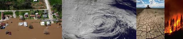
Why Extreme Weather Is The New Normal. Here's the intro to a story at theweek.com: "This
year, the U.S. has had 12 billion-dollar disaster events — floods,
wildfires, hurricanes, severe storms, and droughts that each caused more
than $1 billion worth of damage. Adjusted for inflation, there were on
average only about two such events a year in the 1980s, five a year in
the 1990s and 2000s, and almost 11 a year between 2010 and 2015. The
flooding in Louisiana in August was the country's eighth
"once-in-every-500-years" weather event in a little over 12 months.
Wildfires in California and other parts of the West grew at a rate of
90,000 acres a year between 1984 and 2011; in Alaska, four of the 10
worst fire seasons on record have occurred since 2004. The U.N. has
calculated that the number of severe storms, floods, and heat waves
worldwide is five times greater than it was in 1970; the World Bank
estimates that extreme weather today affects 170 million people a year,
up from 60 million three decades ago..."
 Weather Photo of the Week
. Check out this haboob, triggered by thunderstorm downdrafts kicking up a wall of windblown sand and dust. More details via
Capital Weather Gang.
Photo credit:
Chopperguy photographer Jerry Ferguson and Pilot Andrew Park.
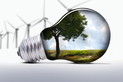
Trump Insider: New Administration Won't Attack Renewable Energy. I hope this isn't just wishful thinking. Here's a clip from a story at
Utility Dive: "...
Energy
is not one of the top five agenda items” on Trump’s to-do list when he
takes office in January, according to a major Trump financial
contributor who said he is a member of the transition team and spoke on
the condition of anonymity. The top issues on that agenda are tax
reform, immigration, reforming health care (Obamacare), infrastructure,
and trade. “Everything with renewables continues; the credits will
remain in place,” he said..."
Best Places To Watch 2017 Eclipse. If you're an astronomy buff it's not too early to plan ahead for next August. Here's an excerpt from
EarthSky: "
The foremost criterion for selecting a site is the weather.
Any location along the path of totality from Oregon to South Carolina
can enjoy good weather on eclipse day, but the western half of the
United States, especially from the Willamette Valley of Oregon to the
Nebraska Sandhills, will enjoy the very best weather odds. You can watch
the weather forecasts starting a week before eclipse day to judge
whether you can strike for a spot close to home or drive further afield.
Wherever you go, every eclipse viewer should have a plan for mobility. Even in the sunniest locations, you don’t want to be caught under a cloud during the precious two minutes of totality...."
The Tiny Kentucky Town That Eclipse Fans Are Obsessing Over. Interested in hearing more about the total eclipse of the sun next summer? Check out this story at
Atlas Obscura: "
Go ahead. Try to book a hotel room online in Hopkinsville, Kentucky,
for the third weekend in August next summer. You can’t. The rooms
appear to be booked solid from August 19th through August 22th. And the
same goes for hotels and motels in nearby Cadiz, Hardin, Oak Grove, or
any other interchange along Interstate 24. Demand is so high that you
have to personally call to make a reservation, and be willing to pay
between $400 to $800 a night. You could say the stars have aligned for
Hopkinsville. Or, more precisely, the Earth, sun and moon will be
perfected aligned. Next summer will be the first time a total solar
eclipse—when the moon completely blocks out the sun—can be witnessed in
the continental United States since 1979..."
File image: NASA.
 The Joys of Pumpkin Spice
.
It's been an interesting week, and nothing calms the nerves like
pumpkin spice...and talking guinea pigs. Thanks to HLN, FLUFF and
YouTube. I predict you're going to like this clip.


 TODAY
TODAY: Mild sunshine. Wow. Winds: SW 8-13. High: 62
SUNDAY NIGHT: A few clouds, still quiet. Low: 42
MONDAY: Partly sunny, a bit cooler. Winds: NW 7-12. High: 54
TUESDAY: Few passing rain showers. Winds: W 10-15. Wake-up: 43. High: 57
WEDNESDAY: Dim sun, honeymoon continues. Winds: S 10-15. Wake-up: 40. High: near 60
THURSDAY: Clouds increase and thicken. Winds: E 10-20. Wake-up: 50. High: 59
FRIDAY: Windswept rain, turning colder late. Winds: SE 15-25. Wake-up: 52. High: 60, then falling sharply
SATURDAY: Gusty, windy, feels like November. Winds: NW 10-20. Wake-up: 36. High: 41
Climate Stories
Caring for Creation: Community Conversation and Book Release November 15 at Minnehaha Academy.
If you're interested in this topic (and most everyone should be) I hope
you'll consider coming out next Tuesday evening, November 15, to
Minnehaha Academy to hear co-author of "
Caring for Creation"
Mitch Hescox and me discuss why climate awareness and a push toward
clean energy are essential, and why people of faith should pay attention
to the trends. Going in this direction will save us money, clean up the
air, and prevent our kids and grandkids from having to deal with a
worst-case climate scenario: "
Minnehaha Academy Welcomes
Meteorologist Paul Douglas and Evangelical Environmental Network
Director Mitch Hescox for a Compelling Climate Change Conversation and
Book Release Event. Join us for this not-to-be-missed community
conversation and book release event about climate change and the
Biblical call for Christians to care about the earth.
In this free evening conversation, you’ll learn:
- Why Christians should lead the charge for caring for God’s creation.
- How climate change goes beyond politics and affects the health, economy, and stability of future generations.
- Tips to help your family and those around you care for the earth..."
 This Year The Antarctic Has Suddenly Started to Disappear
. Co.Exist has the story; here's the intro: "
The
Arctic is melting. We know that already. But now we're in worse
trouble, because the Antarctic is disappearing too. By studying 36 years
of satellite images, researchers have spotted the worrying trend.
Until now, they thought that the Antarctic ice sheet was actually
growing, but that has changed. The Arctic consists of a sea surrounded
by land, and this stops its ice from drifting away every summer. The
Antarctic is the opposite—land surrounded by water—so most of it melts
every year. But every winter it refreezes, covering almost 7 million square miles with sea ice..." (File image: NASA).
Climate Change Risk is "Serious", Exxon Mobil Executive Says. Here's an excerpt from
The Houston Chronicle: "
Two
days after Donald Trump won the White House, Exxon Mobil official
Suzanne McCarron made clear the oil giant's position on climate change.
In a tweet Thursday, she wrote, "The Paris agreement is an important
step forward by governments in addressing the serious risks of
#ClimateChange." Trump made waves on the campaign trail vowing to
"cancel" U.S. involvement in the pact, which was agreed to by close to
200 world leaders in Paris almost 12 months ago. And since Trump's
victory in Tuesday's election, Republicans have cheered a quick end for
President Barack Obama's efforts to reduce greenhouse gas emissions. But
it doesn't look like Exxon Mobil, a steady GOP donor, is on board..."
What Trump Can - And Can't - Do All By Himself on Climate. Here's an excerpt from an analysis at
Science Magazine: "...
Despite the vulnerability of many of his own properties
to sea level rise, on the campaign trail President-elect Donald Trump
stuck with Republican orthodoxy in questioning human-driven climate
change, and criticizing the steps the Obama administration has taken to
combat it. Trump has promised to "cancel" the Paris agreement, the
recently adopted global deal to curb global warming, and to curb climate
regulations from the Environmental Protection Agency (EPA), including
the Clean Power Plan to cut emissions from coal-fired power plants,
during his first 100 days in office..."
Record Hot Years Could Be The "New Normal" by 2025. So reports
Huffington Post: "
Following in the blistering footsteps of 2014 and 2015, this year is on track
to be the warmest on record. And we probably need to get accustomed to
this sweltering heat. If carbon emissions continue to rise at their
current rate, these record hot years will be the “new normal” by 2025, new research shows. Even if we take action to curb emissions, the damage has already been done, warns the study, published Friday in the Bulletin of American Meteorological Society. Human activities have already ensured that the global annual average temperature of 2015 will be the norm “no later than 2040,” the researchers said..."
Michael Bloomberg Has a Plan To Shift The Conversation on Climate Change.
Business Insider reports: "...
Bloomberg
and Pope firmly believe that fixing those flaws will allow the entire
global economy to grow. When they researched current technologies and
initiatives that could address some of the biggest environmental
problems, Pope says they “found that each one had a pretty attractive
set of solutions and that collectively, solving climate will make a lot
of money for the world.” That wasn’t true 20 years ago, when solar and
wind power were vastly more expensive, electric cars were not yet a
reality, it was difficult to monitor and track illegal deforestation,
and far less was known about how to make agriculture more sustainable.
The world’s approach, according to Bloomberg and Pope, is still stuck in
that era..."


No comments:
Post a Comment