Twin Cities Climate Stat Pack From November 5th (through 7 PM)
High Saturday: 73 (Sets new November 5th record - previous: 71 in 2001)
Low Saturday Morning: 43
Precipitation: 0.00"
Rainfall since January 1st: 35.20" (+7.22" from average)
Snowfall: 0"
Snowfall since September 1st: 0" (-1.4" from average)
Other cities that saw records tied/fall Saturday:
- St. Cloud: 72 (tied record also set in 1975)
- Duluth: 70 (previous record: 68 in 1975)
- Rochester: 71 (previous record: 70 in 1893)
- Fargo, ND: 72 (previous record: 70 in 1975)
- Eau Claire, WI: 72 (previous record: 68 in 1975 and 1924)
______________________________
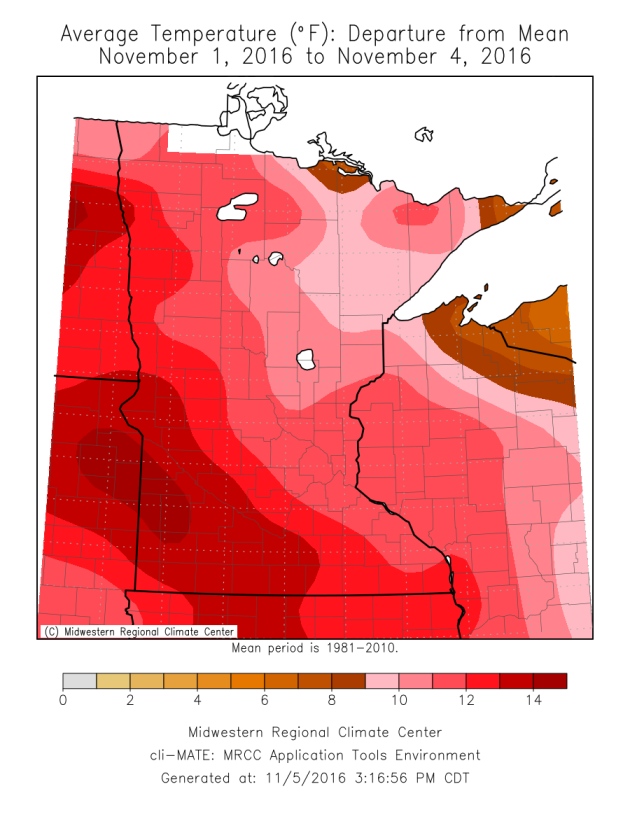
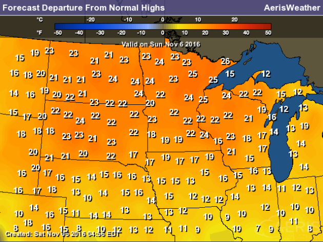
I went walking around a local lake Friday, and the first through that popped in my mind was, "this is great September weather." Too bad it is November. Climatologist Mark Seeley has more on the warm start to the month in his weekly WeatherTalk blog: "Most climate stations in the state are reporting daily temperatures that range from 8 to 15 degrees F above normal for the first few days of November. This pattern is expected to persist well into the month, and may approach the record warmest first half of November which dates back to 2001 That year was the only time the Twin Cities saw daily temperatures average above 50°F for the whole first half of November. Everybody is asking when the other shoe will drop. Perhaps not until the 16th or 17th."
______________________________
149 Days At/Above 70 This Year In The Twin Cities
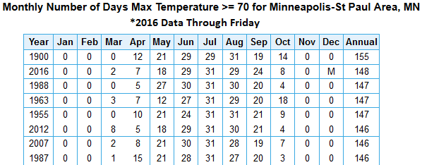
Saturday's high of 73 marked the 149th day at or above 70 degrees so far in 2016. That's the second most we've ever seen in the Twin Cities, only behind 1900 which saw 155 days. While the current forecast won't have us breaking that record, there is another record from 1900 we will break over the next few days. That was the year of the latest first 32 degree reading on record, set on November 7th. We've yet to hit 32 this fall in the Twin Cities, and the forecast would have our first one at least a week away at the minimum.
______________________________
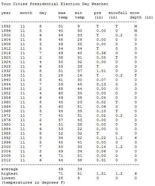
Twin Cities Election Day Weather
Tuesday is Election Day! The Minnesota Climatology Office
put together some past Presidential Election Day Weather for the Twin
Cities. The warmest was back in 2008 with a high of 71. Highs this year
will be in the upper 50s with mainly sunny skies. Here's a quick look at
past Presidential Election Day Weather for the Twin Cities:
______________________________
Recent Warm Temperatures Delaying Fall Fertilizer Application
______________________________
Turn Back The Clocks - Still Feels Like September
By D.J. Kayser, filling in for Paul Douglas
I hope you remembered to turn back your clock overnight as we reentered standard time at 2 AM early this morning. This may be a bright spot to you early risers! Today's sunrise is at 6:59 AM - the first sunrise before 7 AM since September 20th. However, enjoy this pre-7 AM sunrise while it lasts - today is also the last sunrise before 7 AM until we reach February 24th.
The bad part about shifting back to standard time? The return of the really early sunset. Just a few days ago we saw our first sunset before 6 PM of the fall, but as of today our sunset is now before 5 PM and keeps getting earlier until early December. It's just one of the downsides as we head into the winter season.
Even though we turned back the clocks, it's still going to feel more like late September as we head through the day today. Highs will climb to near 70 with mainly sunny skies. While temps will be cooler heading into the work week, we will still be above average for this time of year. Continue to enjoy the warmth while it lasts!
______________________________
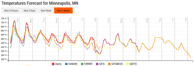
Extended Forecast for Minneapolis
SUNDAY: One more day near 70. Mainly sunny. High 68. Low 48. Chance of precipitation 0%. Wind S 5-10 mph.
MONDAY: Chance of an afternoon shower. High 61. Low 45. Chance of precipitation 20%. Wind S 5-10 mph.
TUESDAY: Some passing clouds for Election Day. High 57. Low 42. Chance of precipitation 0%. Wind N 3-7 mph.
WEDNESDAY: Another fine November day. Partly cloudy skies. High 59. Low 44. Chance of precipitation 0%. Wind SW 3-7 mph.
THURSDAY: A dry cool front passes through. Sunny skies. High 58. Low 44. Chance of precipitation 0%. Wind W 5-10 mph.
FRIDAY: Cooler weather for Veterans Day. Partly cloudy. High 51. Low 38. Chance of precipitation 10%. Wind N 5-10 mph.
SATURDAY: Morning clouds. Afternoon sunshine. High 49. Low 39. Chance of precipitation 10%. Wind SW 5-10 mph.
______________________________
This Day in Weather History
November 6th
1993: Heavy lake effect snow falls over the eastern portion of Lake of the Woods. 3-4 inches around Baudette.November 6th
1947: A snowstorm moves through Minnesota with high winds, causing a million dollars in damage.
______________________________
Average Temperatures & Precipitation for Minneapolis
November 6th
November 6th
Average High: 47F (Record: 73F set in 1893)
Average Low: 31F (Record: 0F set in 1991)
Average Precipitation: 0.06" (Record: 1.54" set in 2000)
Average Snow: 0.2" (Record: 1.6" in 1933)
______________________________
Average Low: 31F (Record: 0F set in 1991)
Average Precipitation: 0.06" (Record: 1.54" set in 2000)
Average Snow: 0.2" (Record: 1.6" in 1933)
______________________________
Sunrise/Sunset Times for Minneapolis
November 6th
Sunrise: 6:59 AMNovember 6th
Sunset: 4:54 PM
*Length Of Day: 9 hours, 54 minutes and 40 seconds
*Daylight Lost Since Yesterday: ~2 minutes and 39 seconds
*Next Sunrise That Is After 7 AM: November 7th (7:01 am)
*Earliest Sunset Of The Year: December 9th (4:31 pm)
______________________________
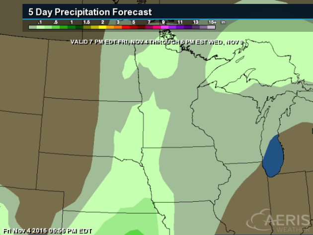
Minnesota Weather Outlook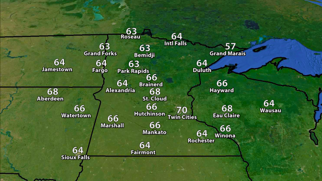
______________________________
National Weather Stories
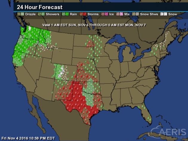
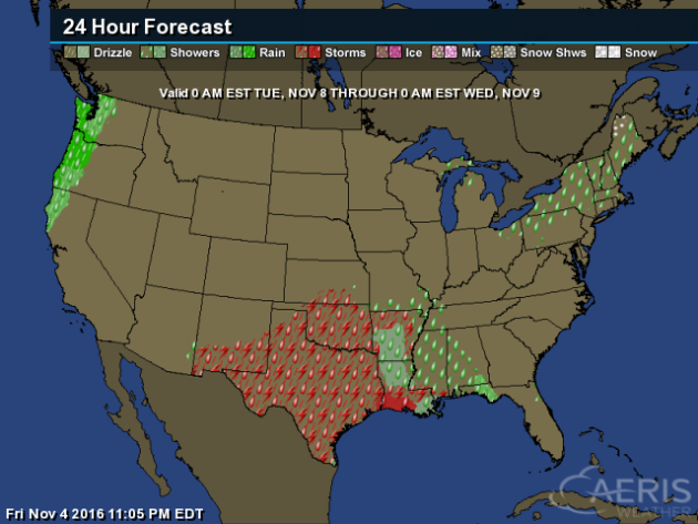
As
we head into Sunday, heavy rain will be possible across the Pacific
Northwest as another front moves onshore. Showers and storms will be
possible across the mid-section of the country, with even some mountain
snow possible in the Colorado Rockies. Parts of northern New England
could see some rain and snow, while some showers pop across Florida.
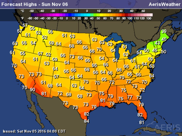
New
England will once again be the cool spot of the nation Sunday with
highs only in the 30s and 40s, meanwhile 70s will stretch as far north
as the upper Midwest. 90s will be possible in parts of the Desert
Southwest.
Election Day Forecast

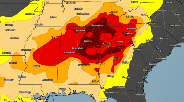
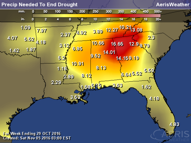
Southeast Drought Continues
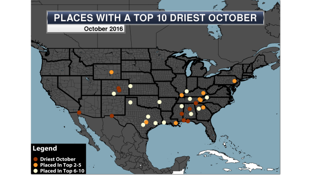
- Birmingham, AL – 0.00″ (driest October on record)
- Colorado Springs, CO – 0.00″ (driest October on record)
- El Paso, TX – 0.00″ (driest October on record)
- Mobile, AL – 0.00″ (driest October on record) – only the second overall month on record with no precipitation falling
- Pensacola, FL – 0.00″ (driest October on record)
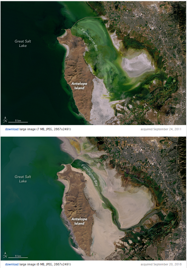
The Great Salt Lake Is Drying Up
______________________________
Thanks for checking in and have a great Sunday! Don't forget to follow me on Twitter (@dkayserwx) and like me on Facebook (Meteorologist D.J. Kayser)!
- D.J. Kayser

No comments:
Post a Comment