1" snow on the ground at MSP International Airport.
36 F. high yesterday in the Twin Cities.
24 F. average high on December 28.
23 F. high on December 28, 2015.
December 29, 1999: Minneapolis soars to a high temperature of 53 degrees.
Living in a Land of Low Weather Expectations
You move to San Diego because you want consistently lukewarm, sunny weather. Florida is balmy much of the year, but a miserable sauna during the summer. Arizona? A fine choice, if you don't mind living in a DESERT.
Minnesota? We're relieved if the mosquitoes are small, if the hail is only pea-size or less - and December temperatures reach freezing. Yesterday, with bright sun, light winds and mid-30s it felt pretty good out there. Admit it.
2016 was the wettest year on record for the Twin Cities. Accurate, reliable data goes back to 1871. Every month was milder than average, and in spite of -20F a few Sundays ago this month should be no exception. We end 2016 on a relatively mild note, with 30s into Monday.
Models hint at a few inches of snow, possibly plowable, Monday into Tuesday, followed by single-digit highs and subzero lows the latter half of next week. Pretty typical for January. Next month may be partial payback for a 9-month boating season in 2016. Partly Nanook.
But no drama is brewing for New Year's weekend festivities. It can always be worse. Trust me.
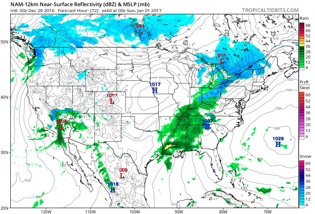
New Year's Eve Map. The map above shows 12 KM NAM guidance valid 7 PM Saturday evening. Rain is likely over the Mid South and Ohio River Valley with a little wet snow for Columbus, Cleveland and Buffalo. More heavy showers push across southern California with a rain/snow mix pushing ashore over Washington State. Otherwise the weather looks quiet and seasonably chilly Saturday night.
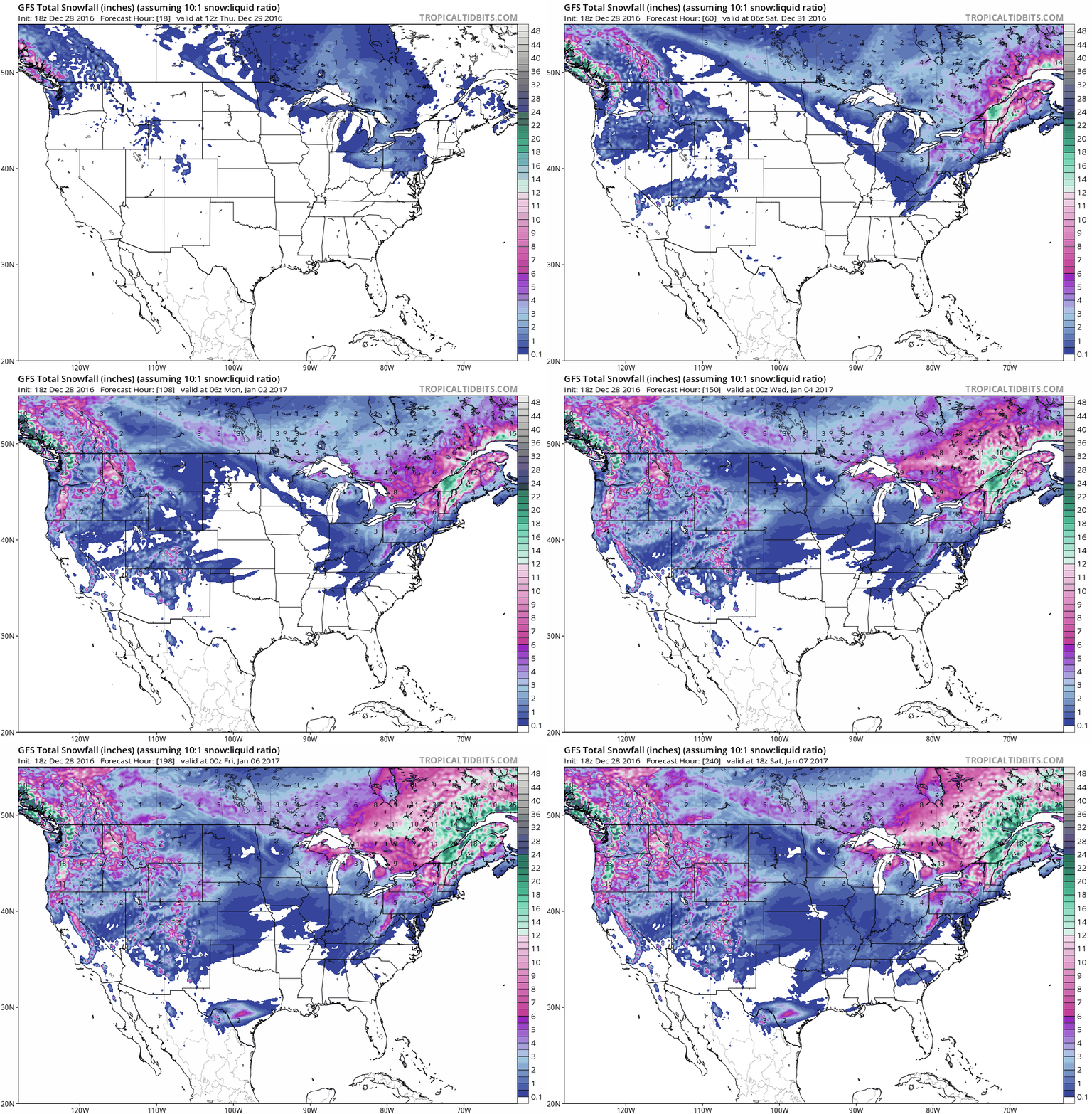
10-Day Snowfall Forecast. This is GFS data, showing the heavy snow falling on interior New England today (Boston may see wind gusts over 50 mph); lake effect downwind of the Great Lakes, and more heavy snow from the Pacific Northwest into the highest peaks of the Rockies. Accumulating snow for San Antonio, Texas by January 5-6? At this point I wouldn't rule anything out. Source: Tropicaltidbits.com.
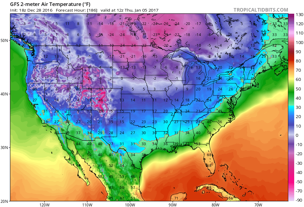
One Week From Today. Although not as harsh as December 18, when the Twin Cities woke up to -20F, temperatures will be very January-like the latter half of next week with subzero lows for the northern Plains and Upper Mississippi Valley. The rest of the USA: chilly, but certainly not ridiculously cold.
The Dangers of Hypothermia. A slow drop in body temperature, hypothermia can be fatal if not caught in time. NOAA has good advice on symptoms and prevention: "When
your body temperature sinks below 96°F, you have hypothermia, a serious
health hazard that occurs when body temperature is lowered to much. Get
medical attention immediately. Move the victim inside to a heated
location and begin warming the center of the body first. If the person
is unconscious, administer CPR. Hypothermia can occur in temperatures as
warm as 60°F, particularly in water or with if you are outside a long
time and not dressed for the weather. Of the approximately 1,300 people
the CDCP lists as being killed by hypothermia each year, most are
seniors, according to the National Institute of Aging, but some are
children and young adults. Everyone needs to be careful. Some medicines,
problems with circulation, and certain illnesses may reduce your
ability to resist hypothermia. As you age, your body becomes less
efficient at letting you know when you are too cold. In addition, older
people tend not to shiver effectively, one of the ways the body warms
itself up. Remember these tips to help prevent hypothermia:
- Dress in layers
- Wrap up well when going outside in the cold.
- Avoid breezes and drafts indoors.
- Eat nutritious food and wear warm clothes to ward off winter chill.
- Wear a warm hat in the winter.
- Eat hot foods and drink warm drinks several times during the day.
- If you live alone, ask a family member of neighbor to check on you daily or have a camera installed that a family member can view on their computer.
- Ask your doctor if any medicine you're taking increases your risk of hypothermia. Drugs that may cause a problem include barbiturates, benzodiazepines, chlorpromazine, reserpine, and tricyclic antidepressants..."
File photo: NOAA.
Map credit: "This is the NOAA GFS Ensemble. It’s an average of many model runs, and the ECMWF Model run in the UK is also showing much the same. This adds confidence to the forecast. Note the rising pressures over Greenland as well. This would correspond to a slight negative in the NAO."
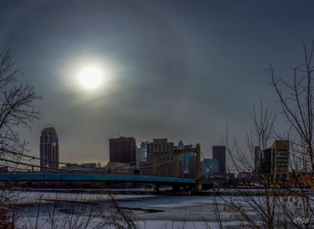
Good News on a Depressing Topic.
So maybe SAD (Seasonal Affective Disorder) isn't "settled science"? Is
it all in our heads? Here's an except of an interesting story at The Buffalo News: "...A
recent study in the Journal of Clinical Psychological Science, if it
continues to stand up to peer review, essentially debunks SAD as a real
condition. Scientific American magazine outlines some of the study’s
findings and other evidence. The investigators in the study did not
initially question the acceptance of SAD as a real condition, and they
did expect to find a correlation of more occurrences at higher
latitudes. In other words, they went in to their work expecting to learn
more about SAD, rather than to raise questions about its validity.
Instead, what they and the Centers for Disease Control and Prevention
found (the CDC had done a large, detailed phone survey) was quite to the
contrary of what had been widely accepted for three decades..."
Study Finds Seasonal Affective Disorder Doesn't Exist. Here's a summary of recent research at Scientific American.
Photo credit above: Steve Burns.
Map credit: 1059 preliminary tornadoes in 2016, according to NOAA SPC.
Severe Thunderstorms Down Under. Check out a severe thunderstorm warning; a 60 minutes "Nowcast" issued for Melbourne, Australia, last night. The graphics come from the Australia Bureau of Meteorology.
Photo credit: "Fuel tanks are seen after floodwaters rose because of Hurricane Matthew in Lumberton, N.C." (Chris Keane/Reuters)
Doppler radar loop: Hurricane Matthew on October 6, 2016.
A Celebration of Clouds: From Space, Earth Has an Elegant Atmosphere. Here's an excerpt of a good read at NASA's Earth Observatory: "Earth has been referred to as "the blue planet” due to its abundance of water. "The cloudy planet” would be equally appropriate. At any given time, about two-thirds of Earth’s surface is covered by these masses of water and ice particles suspended in the atmosphere. Clouds can be a nuisance for scientists trying to use satellites to observe features on the surface—such as volcanic eruptions, floods, or phytoplankton blooms. But for some scientists, clouds are exactly what they want to see. Clouds help make the weather and affect Earth’s climate, and they can make a difference in the success or failure of efforts to simulate both. (Correctly representing clouds in climate models, it turns out, is really hard to do). But sometimes, clouds manifest in such a way that they simply inspire awe..."
Image credit: "Nearly 70 percent of Earth's surface is covered by clouds at any given time. While cloud cover can obscure the surface and frustrate satellite imagery of land and sea, clouds offer a beautiful glimpse of our atmosphere and its processes." (NASA Earth Observatory image by Joshua Stevens, using Blue Marble imagery.)
When Robots Take Jobs, Workers Deserve Compensation.
Technology will save us? Government will provide a safety net when
entire industries are disrupted? Or is this a matter of personal
responsibility - learning new skills to remain perpetually employable?
Here's an excerpt from Financial Times: "...Stressing
that technology was not destiny, the report argued it was too soon to
abandon the possibility of near-full employment. “The issue is not that
automation will render the vast majority of the population
unemployable,” wrote Jason Furman, chair of the Council of Economic
Advisers. “Instead, it is that workers will either lack the skills or
the ability to successfully match with the good, high paying jobs
created by automation...”
Up In The Air: Meet the Man Who Flies Around the World For Free.
Fascinating, and on some level, a bit sad. What kind of life is this? I
like to fly, but this sounds like aviation purgatory. Here's an excerpt
from RollingStone: "...One
of the fundamental steps a Hobbyist can take is choosing an airline to
compete for top-tier loyalty status; Schlappig chose United. Nothing was
free up front — the object of the game was a return on investment. A
Hobbyist doesn't spend unless he can get the same or greater value in
return. It took Schlappig about a year to master the dozens of
convoluted techniques, exploiting mistakes in ticketing algorithms and
learning the ins and outs of the frequent-flyer programs airlines had
created after deregulation in the late 1970s. The second leg of the game
is credit cards — collecting and canceling as many as possible, and
deploying a series of tricks to reap the reward points that
bank-and-airline-card partnerships would virtually give away. As he
delved deeper, Schlappig learned about a third level, a closely guarded
practice called Manufacture Spend, where Hobbyists harness the power of
the multitudes of credit cards in their pockets..."
Photo credit: "Ben Schlappig is a master of flying around the world — at no cost to himself." Bryan Derballa.
TODAY: Gusty, few flakes in the air. Winds: NW 15-30. High: 30 (20s most of the daylight hours)
THURSDAY NIGHT: Lingering clouds, cold wind. Low: 17
FRIDAY: More clouds than sun. Winds: S 7-12. High: 32
NEW YEAR'S EVE: Windy, turning colder. Slow clearing. Winds: NW 10-20. Wake-up: 19. High: 26
NEW YEAR'S DAY: Partly sunny, good travel day. Winds: S 10-15. Wake-up: 18. High: 34
MONDAY: Wet snow or mix develops. Winds: E 10-15. Wake-up: 26. High: 33
TUESDAY: Few inches of snow? Slick roads. Winds: N 10-20. Wake-up: 17. High: near 20 (falling)
WEDNESDAY: Flurries taper - feels like -15F. Winds: NW 10-15. Wake-up: 3. High: 8
Climate Stories...

Graphic credit: "An Arctic iceberg, pictured in 2015. This year, ice coverage has reached record lows for the early northern winter." AWeith/Wikimedia Commons, CC BY
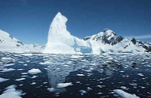
Global Warming 2016: Arctic Spin. Here's an excerpt of a long post on worrying trends at the top of the world: "...Nobody who knows Arctic sea ice was surprised by this. It has been on the decline, overall, for decades, so it’s no surprise that this year’s levels would be at or near their lowest. It’s part and parcel of the ongoing trend of the loss of sea ice in the Arctic. Nor was it a surprise that, even with an ongoing trend, it wasn’t always at its lowest-ever. Most everything in nature, including sea ice, doesn’t just follow a trend, it also constantly fluctuates. Added to the overall tendency, there are ups and downs and downs and ups that make it different from day to day, month to month, even year to year. But over the long haul, the fluctuations — even though they never stop — never really get anywhere. What does, what keeps on going and accumulates until we can’t ignore it any more, is the trend — and for sea ice in the Arctic, that means there’s less and less of it..."
Image credit: "The disappearance of Lake Poopó has not only destroyed the livelihoods of hundreds of fishing families, but also added to a new category of climate refugees." Josh Haner/The New York Times
Map credit: Climate Reanalyzer.
Photo credit: "Waves crash over a sea wall at Naval Base Ventura County." Courtesy of Naval Base Ventura County.
No comments:
Post a Comment