Twin Cities Climate Stat Pack From December 10th (through 6 PM)
High Saturday: 12
Low Saturday Morning: 4
Precipitation: 0.04"
Precipitation since January 1st: 38.35" (+8.48" from average)
Snowfall: 0.8"
Snowfall since September 1st: 5.5" (-8.5" from average)
______________________________
Get Ready To Bundle Up! Cold Blast This Week
Have you gotten your parka out of the closet yet this winter? If not, you may want to find it - and fast!
Saturday saw daytime highs only in the teens here in the Twin Cities, the coldest high we've seen so far this season. The previous coldest had been 20 on Friday. However, we are going to wish for highs in the teens and 20s by the middle of next week.
After a snowy Sunday, with weekend total snow accumulations of 4"+ in the Twin Cities, an Arctic front will slide through the region during the beginning of the week. This will help push south the coldest air we've seen so far this season across the upper Midwest. Highs later this week will only be in the single digits above zero in the Twin Cities, and likely not make it above zero at times across northern Minnesota. We'll also see our first subzero lows since mid-February.
There are also signs that we could see an additional push of cold air next weekend, extending the bitter cold into the week leading up to Christmas. It looks like winter has finally arrived in Minnesota.
______________________________
Extended Forecast for Minneapolis
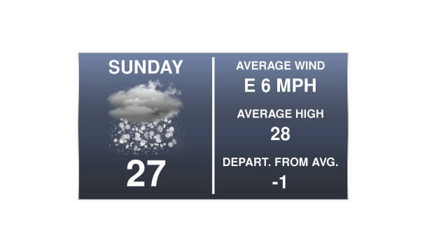
SUNDAY: Snow slowly tapers off. High 25. Low 10. Chance of precipitation 100%. Wind NE 5-10 mph.
MONDAY: Slight PM snow chance. Mainly cloudy. High 15. Low -1. Chance of precipitation 20%. Wind SW 3-5 mph.
TUESDAY: Bitter cold starts to settle in. High 6. Low -3. Chance of precipitation 0%. Wind W 5-10 mph.
WEDNESDAY: Coldest day this week. High 3. Low -6. Chance of precipitation 0%. Wind W 10-15 mph.
THURSDAY: Arctic sunshine continues. High 7. Low -3. Chance of precipitation 0%. Wind W 10-15 mph.
FRIDAY: Snow chances on the increase. High 7. Low -1. Chance of precipitation 40%. Wind W 3-5 mph.
SATURDAY: Lingering snow, especially in the AM. High 10. Low -7. Chance of precipitation 30%. Wind N 10-15 mph.
______________________________
This Day in Weather History
December 11th
2010: A blizzard hits much of southern Minnesota. Minneapolis saw a December record 16.3 inches of snow in one calendar day and much of the metro area saw between 15 and 20 inches of snow.
1983: Nine cars fall through the ice at the same time on Buffalo Lake in central Minnesota. There was only 5 to 6 inches of ice on the lake.
1979: The temperature drops in Roseville from 48 degrees at 2 pm to zero by dawn of the following day.
1916: Montevideo has its fifty-second consecutive day with no precipitation.
______________________________
Average Temperatures & Precipitation for Minneapolis
December 11th
Average High: 28F (Record: 56F set in 1913)
Average Low: 14F (Record: -14F set in 1972)
Average Precipitation: 0.04" (Record: 1.16" set in 2010)
Average Snow: 0.4" (Record: 16.3" in 2010)
______________________________
Sunrise/Sunset Times for Minneapolis
December 11th
Sunrise: 7:42 AM
Sunset: 4:32 PM
*Length Of Day: 8 hours, 49 minutes and 55 seconds
*Daylight Lost Since Yesterday: ~0 minutes and 48 seconds
*Latest Sunrise Of The Year: December 27th – January 8th (7:51 am)
*Next Sunset At/After 5 PM: January 17th (5:00 pm)
______________________________
Minnesota Weather Outlook
 Snow
will be lingering across Minnesota as we head into Sunday across the
region, with highs in the mid/upper 20s across the Twin Cities. Highs
will only be in the teens across northern Minnesota.
Snow
will be lingering across Minnesota as we head into Sunday across the
region, with highs in the mid/upper 20s across the Twin Cities. Highs
will only be in the teens across northern Minnesota.
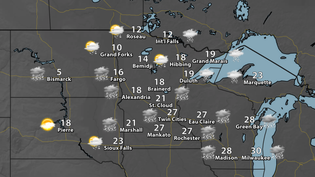
 Here's
the forecast for the Twin Cities Sunday. Highs will be around average
for this time of the year, with winds out of the east.
Here's
the forecast for the Twin Cities Sunday. Highs will be around average
for this time of the year, with winds out of the east.
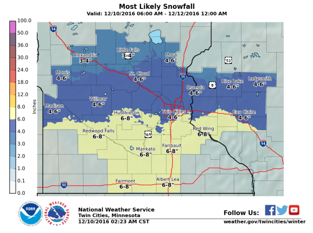 Snow
totals across southern Minnesota will be in the 4-8" range, with totals
approaching 4-6" across the Twin Cities. This is TOTAL snow between
Saturday and Sunday, not a Sunday-only total.
Snow
totals across southern Minnesota will be in the 4-8" range, with totals
approaching 4-6" across the Twin Cities. This is TOTAL snow between
Saturday and Sunday, not a Sunday-only total.
Because of the snow expected, Winter Weather Advisories (in purple) are in effect for southern Minnesota through Sunday evening, including here in the Twin Cities.
 After
the snow... here comes the cold. These are highs for Wednesday across
Minnesota - parts of central and southern Minnesota will barely make it
into the single digits above zero during the day. Meanwhile, across much
of northern Minnesota, highs will remain below zero.
After
the snow... here comes the cold. These are highs for Wednesday across
Minnesota - parts of central and southern Minnesota will barely make it
into the single digits above zero during the day. Meanwhile, across much
of northern Minnesota, highs will remain below zero.
 You
can see the nose dive we take in temperatures by the middle of next
week. Make sure you enjoy the near-average day Sunday while it lasts!
Another little warm up is currently pegged in the models for late this
week/early next weekend, before another cold blast works in for the
beginning of the week right before Christmas. The good news, looking
long-long term, is that the models are hinting at another warm up in
time for Christmas. Only time will tell.
You
can see the nose dive we take in temperatures by the middle of next
week. Make sure you enjoy the near-average day Sunday while it lasts!
Another little warm up is currently pegged in the models for late this
week/early next weekend, before another cold blast works in for the
beginning of the week right before Christmas. The good news, looking
long-long term, is that the models are hinting at another warm up in
time for Christmas. Only time will tell.
______________________________
National Weather Outlook
84 Hour Forecast
As we head through Sunday and into early next week, a snowstorm that will bring areas like Chicago, Milwaukee and Detroit the potential of at least six inches of snow will be moving east. Places like Boston and New York City could pick up a few inches of snow Sunday Night into Monday morning before changing over to rain. Another batch of light snow could be possible across the Great Lakes early next week, followed by more lake effect snow toward the middle and end of the week. Out west, a stream of moisture will be flowing onshore across northern California and into Nevada and Utah by Tuesday, and continue through the middle of the week. Significant mountain snow will be possible.
 Heavy Snow Through Monday Plains To Northeast
Starting with the event ongoing Sunday and into Monday from the Midwest to Great Lakes, a long duration snow will finally come to an end Sunday evening across areas such as Chicago, Milwaukee and the Twin Cities. The system will continue to head east Sunday Night into Monday, bringing with it some accumulating snow across the Northeast, including the potential of a few inches of snow in Boston and New York City before changing over to rain during the day Monday. Here's a look at expected overall snow totals for the Milwaukee, Chicago, Detroit, Boston and New York City metros:
Milwaukee Area Forecast:
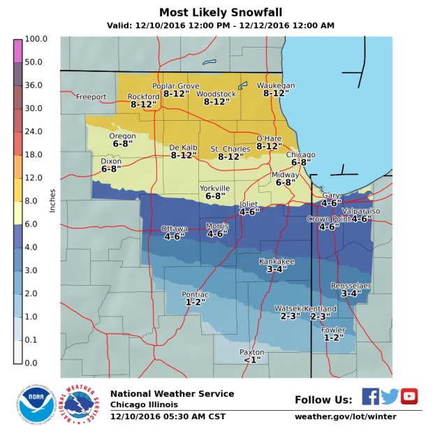
 Chicago Area Forecast:
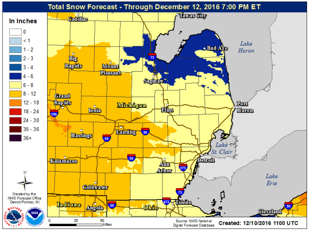
 Detroit Area Forecast:
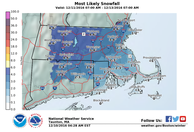
 Boston Area Forecast:
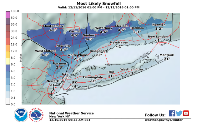
 New York City Area Forecast:
 Snow Potential Over The Next 10 Days
After this snowstorm moves through the Northeast, another batch of snow will move through early in the week, bringing with it some light snow totals across the upper Midwest and Great Lakes. After that, with the cold air in place, the lake effect machine will start up once again during the middle of the week, bringing heavy snow to the favored Great Lakes snowbelts. Significant western mountain snow will be possible into the middle of next week from California to Colorado and Wyoming with a moist Pacific plume. The models are hinting at another storm system late next week which could bring another shovelable/plowable snow to parts of the Midwest.
 Five Day Precipitation Outlook
Parts of the Great Lakes could pick up over an inch of moisture through Thursday, mainly coming in the form of snow. Meanwhile, parts of the eastern U.S. could pick up over an inch of much needed precipitation. Heavy amounts of precipitation are also expected out west, with the potential of a few inches of rain for the Bay Area and (once again) heavy mountain snow.
 Ready For Winter To Settle In?
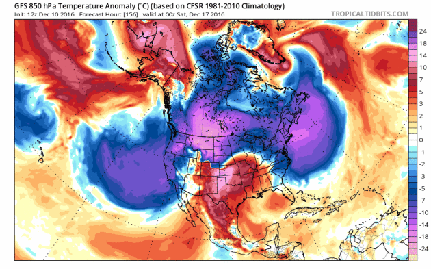
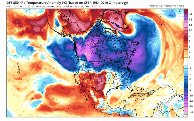 The
coldest air of the season (at least so far) is getting ready to plunge
south as we head into the work week behind an Arctic front. This will
bring temperatures that are a good 10-25 degrees or greater below
average to parts of the upper Midwest by Tuesday and Wednesday. This
animation above shows 850 mb temperature anomalies from Sunday, December
11th through Saturday, December 17th, with a large batch of colder than
average air moving into the upper Midwest, then eventually toward the
east coast.
The
coldest air of the season (at least so far) is getting ready to plunge
south as we head into the work week behind an Arctic front. This will
bring temperatures that are a good 10-25 degrees or greater below
average to parts of the upper Midwest by Tuesday and Wednesday. This
animation above shows 850 mb temperature anomalies from Sunday, December
11th through Saturday, December 17th, with a large batch of colder than
average air moving into the upper Midwest, then eventually toward the
east coast.
Bitterly Cold Highs Wednesday
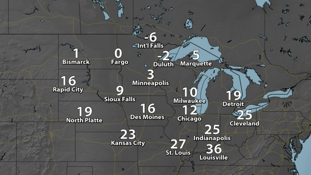 These
are actual forecast HIGHS for Wednesday across the upper Midwest. Parts
of Minnesota and North Dakota will not make it above zero for the
entire day. Meanwhile, temperatures will struggle to reach the teens in
Milwaukee and Chicago, where they should have a nice layer of snow on
the ground by them helping to keep temperatures cooler.
These
are actual forecast HIGHS for Wednesday across the upper Midwest. Parts
of Minnesota and North Dakota will not make it above zero for the
entire day. Meanwhile, temperatures will struggle to reach the teens in
Milwaukee and Chicago, where they should have a nice layer of snow on
the ground by them helping to keep temperatures cooler.
Departure From Average Temperatures Wednesday
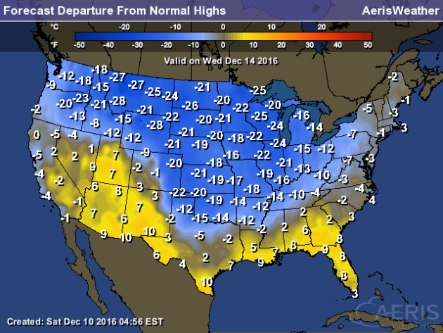 Highs
Wednesday will be a good 10-25 degrees below average for this time of
year as far south as northern Texas, Oklahoma and Arkansas. This cold
weather will continue to push east toward the end of the week.
Highs
Wednesday will be a good 10-25 degrees below average for this time of
year as far south as northern Texas, Oklahoma and Arkansas. This cold
weather will continue to push east toward the end of the week.
Forecast Wind Chills Late This Week
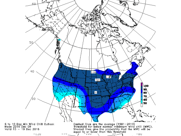 Brrr!
This chart shows the coldest wind chill expected between the 15th and
19th of this month (in the dashed lines) as well as where that ranks vs.
climatology this time of year (in the shading). Minimum wind chills for
that time period will be far below the climatological average - even in
the 90th percentile as far south as Dallas.
Brrr!
This chart shows the coldest wind chill expected between the 15th and
19th of this month (in the dashed lines) as well as where that ranks vs.
climatology this time of year (in the shading). Minimum wind chills for
that time period will be far below the climatological average - even in
the 90th percentile as far south as Dallas.
Coldest Wind Chills
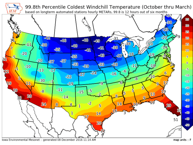 With the upcoming cold, the Iowa Environmental Mesonet put together this map of "the temperature at which we'd expect to see 12 hours of wind chill at that level or colder"
during the selected months. Even as far south as northern Texas we can
see wind chills dip into the single digits below zero during the coldest
parts of the winter. Read more about this map from the IEM by clicking here.
With the upcoming cold, the Iowa Environmental Mesonet put together this map of "the temperature at which we'd expect to see 12 hours of wind chill at that level or colder"
during the selected months. Even as far south as northern Texas we can
see wind chills dip into the single digits below zero during the coldest
parts of the winter. Read more about this map from the IEM by clicking here.
Another Cold Blast The Week Before Christmas?
 There
are hints in the models that another cold blast could work south out of
Canada just in time for next weekend and the week before Christmas,
plunging temperatures once again across a good portion of the country.
We will have to keep our eye on this as we head through the next few
days... and to see how long it will last.
There
are hints in the models that another cold blast could work south out of
Canada just in time for next weekend and the week before Christmas,
plunging temperatures once again across a good portion of the country.
We will have to keep our eye on this as we head through the next few
days... and to see how long it will last.
______________________________
 Colliding Clouds
It’s the weekend, and I know you want to relax. So why not watch a couple clouds crash into each other? This is part of Mitchell F. Chan’s new art piece which you can view in person in Toronto, but only until January 7th. Find out more in this Gizmodo article written by Andrew Liszewski.
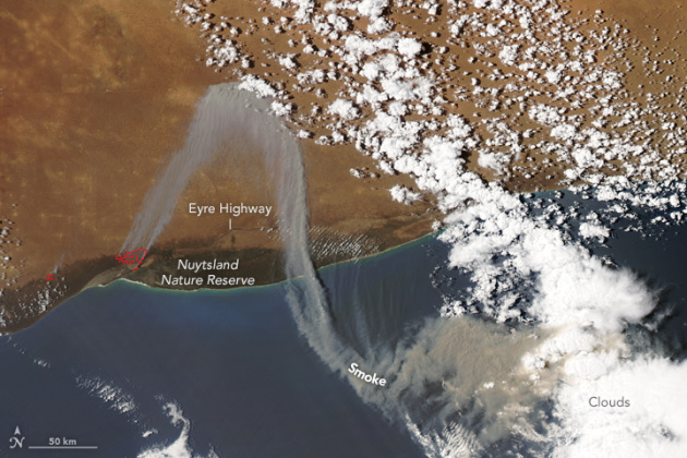 Zigzagging Smoke Over Australia
I always find it interesting what we can see on satellite. This picture above (courtesy of NASA) shows the Cocklebiddy fire on December 7th across western Australia. You can see the smoke plume zigzagging across the region. This fire did shut down the Eyre Highway for a time. Click to read more from NASA about this image.
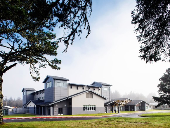
(Photo: Pete Eckert)A Gym Built To Withstand A Tsunami
One day a tsunami will hit the Pacific Northwest. It’s bound to happen. Westport, WA has taken some steps in order to prepare for one by building an elementary gymnasium that can protect 1,000 people. WIRED has a fascinating story on how they decided to build the structure – and still make it look friendly to elementary school kids: “We tried to employ anything we could to make it more relatable to an elementary school student who is four feet tall,” says Brian Ho, associate at TCF Architecture. That’s no mean feat for a structure surrounded by steel columns, clad in concrete masonry and metal walls, topped by a six-inch-thick steel-and-concrete roof, and anchored by concrete piles that extend 55-feet into the sandy earth.”
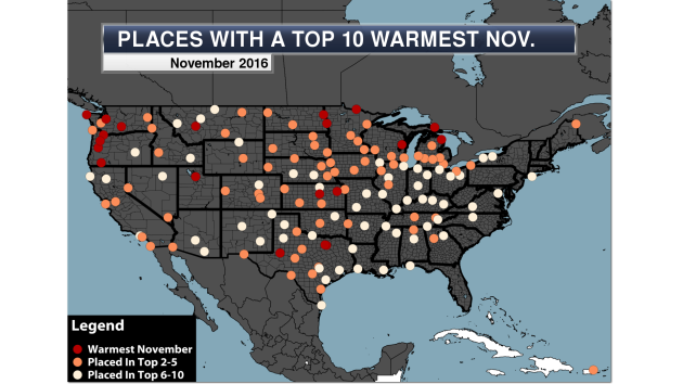 Another Warm Month Across The County
Are we done sweltering yet? 2016 saw the second warmest November on record for the lower 48, with three states seeing their warmest November on record (Washington, Idaho and North Dakota). Meanwhile, 20 long term NWS climate locations saw their warmest November on record, and 154 total sites saw a top ten warmest. Click to read more from AerisWeather.
 Boston Preparing For Climate Change
On Thursday, the City of Boston released a comprehensive study on how climate change would affect the city, including proposed solutions on how to adapt to our ever changing climate. The report states that Boston has seen 21 events since 1991 that were declared either federal or state disasters, and that the number of events are likely to increase in the future. You can read the whole report on the Climate Ready Boston website.
 Clean Energy To Make Your iPhone?
Your next iPhone (okay… maybe your second or third next iPhone) could be at least partially made with wind power. AppleInsider has an article stating that Apple has signed a deal to bring clean wind power to its Chinese suppliers. This is a change for Apple, who has primarily relied on solar power in the past for clean power. More from the AppleInsider article: “The (South China Morning) Post didn't indicate which Apple suppliers would benefit from the arrangement, or how much power Apple is hoping to supply. Recently, however, Lens Technology said it would fully power its glass production with renewable sources by the end of 2018, doing so partly through wind farms in Hunan province.”
______________________________
Thanks for checking in and have a great Sunday! Don't forget to follow me on Twitter (@dkayserwx) and like me on Facebook (Meteorologist D.J. Kayser)!
- D.J. Kayser

High Saturday: 12
Low Saturday Morning: 4
Precipitation: 0.04"
Precipitation since January 1st: 38.35" (+8.48" from average)
Snowfall: 0.8"
Snowfall since September 1st: 5.5" (-8.5" from average)
______________________________
Get Ready To Bundle Up! Cold Blast This Week
Have you gotten your parka out of the closet yet this winter? If not, you may want to find it - and fast!
Saturday saw daytime highs only in the teens here in the Twin Cities, the coldest high we've seen so far this season. The previous coldest had been 20 on Friday. However, we are going to wish for highs in the teens and 20s by the middle of next week.
After a snowy Sunday, with weekend total snow accumulations of 4"+ in the Twin Cities, an Arctic front will slide through the region during the beginning of the week. This will help push south the coldest air we've seen so far this season across the upper Midwest. Highs later this week will only be in the single digits above zero in the Twin Cities, and likely not make it above zero at times across northern Minnesota. We'll also see our first subzero lows since mid-February.
There are also signs that we could see an additional push of cold air next weekend, extending the bitter cold into the week leading up to Christmas. It looks like winter has finally arrived in Minnesota.
______________________________
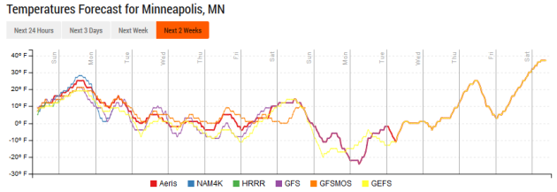
Extended Forecast for Minneapolis
SUNDAY: Snow slowly tapers off. High 25. Low 10. Chance of precipitation 100%. Wind NE 5-10 mph.
MONDAY: Slight PM snow chance. Mainly cloudy. High 15. Low -1. Chance of precipitation 20%. Wind SW 3-5 mph.
TUESDAY: Bitter cold starts to settle in. High 6. Low -3. Chance of precipitation 0%. Wind W 5-10 mph.
WEDNESDAY: Coldest day this week. High 3. Low -6. Chance of precipitation 0%. Wind W 10-15 mph.
THURSDAY: Arctic sunshine continues. High 7. Low -3. Chance of precipitation 0%. Wind W 10-15 mph.
FRIDAY: Snow chances on the increase. High 7. Low -1. Chance of precipitation 40%. Wind W 3-5 mph.
SATURDAY: Lingering snow, especially in the AM. High 10. Low -7. Chance of precipitation 30%. Wind N 10-15 mph.
______________________________
This Day in Weather History
December 11th
2010: A blizzard hits much of southern Minnesota. Minneapolis saw a December record 16.3 inches of snow in one calendar day and much of the metro area saw between 15 and 20 inches of snow.
1983: Nine cars fall through the ice at the same time on Buffalo Lake in central Minnesota. There was only 5 to 6 inches of ice on the lake.
1979: The temperature drops in Roseville from 48 degrees at 2 pm to zero by dawn of the following day.
1916: Montevideo has its fifty-second consecutive day with no precipitation.
______________________________
Average Temperatures & Precipitation for Minneapolis
December 11th
Average High: 28F (Record: 56F set in 1913)
Average Low: 14F (Record: -14F set in 1972)
Average Precipitation: 0.04" (Record: 1.16" set in 2010)
Average Snow: 0.4" (Record: 16.3" in 2010)
______________________________
Sunrise/Sunset Times for Minneapolis
December 11th
Sunrise: 7:42 AM
Sunset: 4:32 PM
*Length Of Day: 8 hours, 49 minutes and 55 seconds
*Daylight Lost Since Yesterday: ~0 minutes and 48 seconds
*Latest Sunrise Of The Year: December 27th – January 8th (7:51 am)
*Next Sunset At/After 5 PM: January 17th (5:00 pm)
______________________________
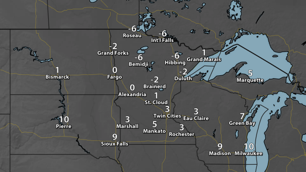
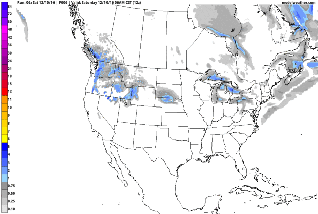
Minnesota Weather Outlook
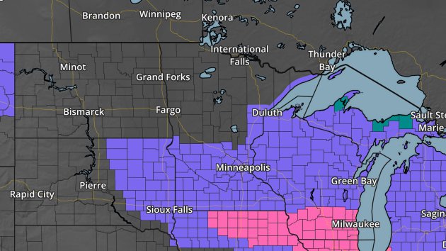
Because of the snow expected, Winter Weather Advisories (in purple) are in effect for southern Minnesota through Sunday evening, including here in the Twin Cities.
After
the snow... here comes the cold. These are highs for Wednesday across
Minnesota - parts of central and southern Minnesota will barely make it
into the single digits above zero during the day. Meanwhile, across much
of northern Minnesota, highs will remain below zero.______________________________
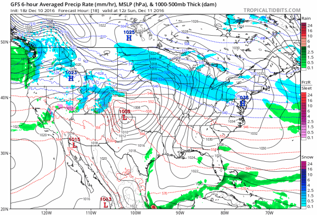
National Weather Outlook
84 Hour Forecast
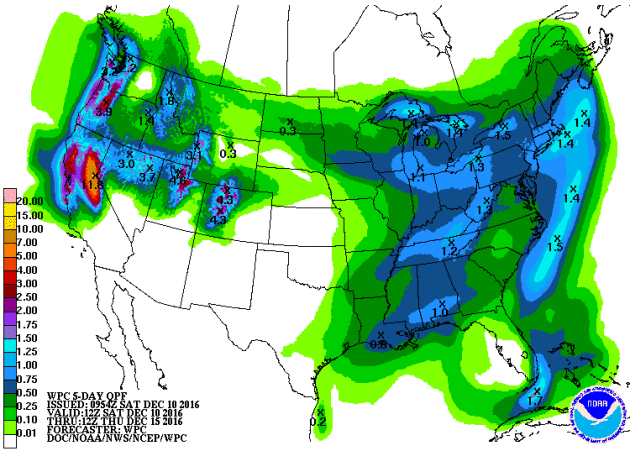
As we head through Sunday and into early next week, a snowstorm that will bring areas like Chicago, Milwaukee and Detroit the potential of at least six inches of snow will be moving east. Places like Boston and New York City could pick up a few inches of snow Sunday Night into Monday morning before changing over to rain. Another batch of light snow could be possible across the Great Lakes early next week, followed by more lake effect snow toward the middle and end of the week. Out west, a stream of moisture will be flowing onshore across northern California and into Nevada and Utah by Tuesday, and continue through the middle of the week. Significant mountain snow will be possible.
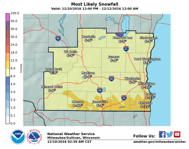
Starting with the event ongoing Sunday and into Monday from the Midwest to Great Lakes, a long duration snow will finally come to an end Sunday evening across areas such as Chicago, Milwaukee and the Twin Cities. The system will continue to head east Sunday Night into Monday, bringing with it some accumulating snow across the Northeast, including the potential of a few inches of snow in Boston and New York City before changing over to rain during the day Monday. Here's a look at expected overall snow totals for the Milwaukee, Chicago, Detroit, Boston and New York City metros:
Milwaukee Area Forecast:
After this snowstorm moves through the Northeast, another batch of snow will move through early in the week, bringing with it some light snow totals across the upper Midwest and Great Lakes. After that, with the cold air in place, the lake effect machine will start up once again during the middle of the week, bringing heavy snow to the favored Great Lakes snowbelts. Significant western mountain snow will be possible into the middle of next week from California to Colorado and Wyoming with a moist Pacific plume. The models are hinting at another storm system late next week which could bring another shovelable/plowable snow to parts of the Midwest.
Parts of the Great Lakes could pick up over an inch of moisture through Thursday, mainly coming in the form of snow. Meanwhile, parts of the eastern U.S. could pick up over an inch of much needed precipitation. Heavy amounts of precipitation are also expected out west, with the potential of a few inches of rain for the Bay Area and (once again) heavy mountain snow.
Bitterly Cold Highs Wednesday
Departure From Average Temperatures Wednesday
Forecast Wind Chills Late This Week
Coldest Wind Chills
Another Cold Blast The Week Before Christmas?
______________________________
It’s the weekend, and I know you want to relax. So why not watch a couple clouds crash into each other? This is part of Mitchell F. Chan’s new art piece which you can view in person in Toronto, but only until January 7th. Find out more in this Gizmodo article written by Andrew Liszewski.
I always find it interesting what we can see on satellite. This picture above (courtesy of NASA) shows the Cocklebiddy fire on December 7th across western Australia. You can see the smoke plume zigzagging across the region. This fire did shut down the Eyre Highway for a time. Click to read more from NASA about this image.
(Photo: Pete Eckert)A Gym Built To Withstand A Tsunami
One day a tsunami will hit the Pacific Northwest. It’s bound to happen. Westport, WA has taken some steps in order to prepare for one by building an elementary gymnasium that can protect 1,000 people. WIRED has a fascinating story on how they decided to build the structure – and still make it look friendly to elementary school kids: “We tried to employ anything we could to make it more relatable to an elementary school student who is four feet tall,” says Brian Ho, associate at TCF Architecture. That’s no mean feat for a structure surrounded by steel columns, clad in concrete masonry and metal walls, topped by a six-inch-thick steel-and-concrete roof, and anchored by concrete piles that extend 55-feet into the sandy earth.”
Are we done sweltering yet? 2016 saw the second warmest November on record for the lower 48, with three states seeing their warmest November on record (Washington, Idaho and North Dakota). Meanwhile, 20 long term NWS climate locations saw their warmest November on record, and 154 total sites saw a top ten warmest. Click to read more from AerisWeather.
On Thursday, the City of Boston released a comprehensive study on how climate change would affect the city, including proposed solutions on how to adapt to our ever changing climate. The report states that Boston has seen 21 events since 1991 that were declared either federal or state disasters, and that the number of events are likely to increase in the future. You can read the whole report on the Climate Ready Boston website.
Your next iPhone (okay… maybe your second or third next iPhone) could be at least partially made with wind power. AppleInsider has an article stating that Apple has signed a deal to bring clean wind power to its Chinese suppliers. This is a change for Apple, who has primarily relied on solar power in the past for clean power. More from the AppleInsider article: “The (South China Morning) Post didn't indicate which Apple suppliers would benefit from the arrangement, or how much power Apple is hoping to supply. Recently, however, Lens Technology said it would fully power its glass production with renewable sources by the end of 2018, doing so partly through wind farms in Hunan province.”
______________________________
Thanks for checking in and have a great Sunday! Don't forget to follow me on Twitter (@dkayserwx) and like me on Facebook (Meteorologist D.J. Kayser)!
- D.J. Kayser
You might qualify for a new government solar energy program.
ReplyDeleteDetermine if you're qualified now!